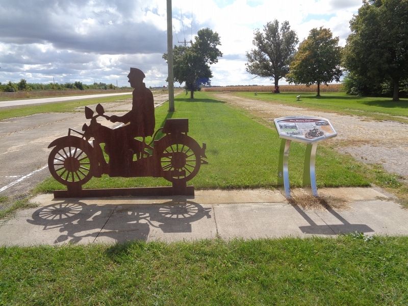
The Illinois State Police was formed in 1922 to protect motorists.
Twenty officers patrolled the state on surplus World War I Harley-Davidson motorcycles. Radio-equipped cycles revolutionized communications in the 1930s. The ISP shifted . . . — — Map (db m158810) HM
Designed by Bill Diaz of Pontiac, Illinois, the "Atlanta: Midway on Illinois' Mother Road" mural captures the spirit of Atlanta's place on Rt. 66. Located approximately 150 miles from both Chicago and St. Louis, Atlanta occupies a central spot in . . . — — Map (db m160819) HM
In its early days, weekly dances and bingo nights accompanied the blue-plate specials served at the Palms Grill Café. The "Grill" was also Atlanta's Greyhound bus-stop. You just turned the light on above the door if you wanted the bus to pick you . . . — — Map (db m160588) HM
During the heyday of Rt. 66, travelers passed hundreds of signs, murals, and other forms of roadside advertising, each hoping to grab its share of attention. Among the more famous of these stood the fiberglass giants created during the 1960s by . . . — — Map (db m160586) HM
As a respite for Rt. 66 travelers and other visitors, the City of Atlanta invites you to relax and enjoy the Atlanta Route 66 Park.
This Information Booth is here to provide you with information about sites to see and things to do in . . . — — Map (db m162544) HM
Atlanta boomed when Route 66 was built in the 1920s.
It didn't last. By 1947 the busy road was rebuilt to bypass town to the east. New businesses flourished on the bypass only to fail again when I-55 replaced the Mother Road in 1977. . . . — — Map (db m162545) HM
Operated for over 54 years by Ernest L. Edwards, Jr. & Family
Home of the celebrated Pig Hip Sandwich - baked fresh pork with tomato & lettuce on a toasted bun with the secret sauce
The Pig Hip Restaurant Museum with Ernie's fine personal . . . — — Map (db m156868) HM
Downtown businesses thrived when Route 66 ran through Elkhart. In 1938, The House by the Side of the Road cafe had an unforgettable customer when actress Shirley Temple stopped for lunch. Afterward, owner J. Smith put a cardboard likeness of the . . . — — Map (db m156874) HM
(front:)
Route 66, the Mother Road, is an American icon that symbolizes romance and freedom of the open road. Born in 1926, Route 66 was one of the first numbered U.S. highways, journeying 2,500 miles from Chicago to Los Angeles. Today, . . . — — Map (db m158187) HM
Abraham Lincoln practiced law here from 1840-1847. This site is located on the original alignment of Route 66 through Lincoln, Illinois. Free admission. — — Map (db m156851) HM
Route 66 promised travelers fun and adventure along the road. The Railsplitter Covered Wagon honors Abraham Lincoln in the only town named for him before he became president. It holds the Guinness World Record as the largest covered wagon and . . . — — Map (db m159307) HM
The Mill opened in 1929 on the original alignment of Route 66, it became famous as a sandwich stand and then a Bar/Restaurant. The Mill is now being restored as a museum. Open by appointment. — — Map (db m156855) HM
A Family Business - The Early Years
Vince Schwenoha opened the Tropics in 1950, naming it in remembrance of his military tour of duty spent in Hawaii. In 1951, Lewis Lee Johnson came to Lincoln from Macomb, Illinois as a meat cutter with . . . — — Map (db m159304) HM
The Coliseum Ballroom on Route 66 was a hopping place on Saturday nights. Benld's ballroom boasted the biggest dance floor between Chicago and St. Louis. People gathered from throughout the region to dance to big bands such as Duke Ellington, . . . — — Map (db m157936) HM
Route 66, the Mother Road, is an American icon that symbolizes romance and freedom of the open road. Born in 1926, Route 66 was one of the first numbered U.S. highways, journeying 2,500 miles from Chicago to Los Angeles. Today, you can still "get . . . — — Map (db m144544) HM
The first hard road connecting Chicago and St. Louis passed through the heart of Carlinville. In 1926, Route 66 opened from Chicago to Los Angeles and followed Route 4 through Illinois. The “Mother Road” Circled the Carlinville Square . . . — — Map (db m144482) HM
This is the second oldest building on the Square. It was built in 1854 and was also the first building on the Square to be three stories tall.
In 1924, Greek immigrant Pete Adam opened the Ariston Restaurant here. Business boomed two years . . . — — Map (db m144480) HM
(2332 E. Side Square)
A hallmark of Route 66 in Illinois, the Ariston Café was originally established in Carlinville in 1924.
Continue to Trail 1 or Trail 2 to Site 4. Continue east down East Main Street to 210 East Main . . . — — Map (db m229837) HM
Russell Soulsby built this station in 1926 with his father, Henry
He ran it with his sister Ola until 1991. For its 65 years of operation; they only sold Shell gasoline. — — Map (db m138433) HM
You are traveling on one of the most famous roads in the world. On September 25, 2005, Illinois Route 66 was designated as a National Scenic Byway by the U.S. Department of Transportation. — — Map (db m144781) HM
Electrified interurban railways were the rage in the early 1900s before Route 66. They offered clean and efficient service, an advantage over locomotives and horses. The Illinois Traction System connected residents in towns like Staunton to . . . — — Map (db m188715) HM
Miserable wages and working conditions in coal mines made conflict between miners and coal companies inevitable in the 1890s. The battle that erupted here immortalized Virden in the history of labor rights. On October 12, 1898, eight miners, four . . . — — Map (db m149885) HM
Route 66, the Mother Road, is an American icon that symbolizes romance and freedom of the open road. Born in 1926, Route 66 was one of the first numbered U.S. highways, journeying 2,500 miles from Chicago to Los Angeles. Today, you can still "get . . . — — Map (db m144542) HM
For nearly four decades, this charming brick building served as a bustling automobile service station on America's most iconic highway, US Route 66 - which ran right past this location through the heart of Edwardsville. Travelers and locals by the . . . — — Map (db m228142) HM
Route 66, the Mother Road, is an American icon that symbolizes romance and freedom of the open road. Born in 1926, Route 66 was one of the first numbered U.S. highways, journeying 2,500 miles from Chicago to Los Angeles. Today, you can still "get . . . — — Map (db m144521) HM
It Began with Four Cars
Cassens Transport began in 1931 when Albert and Arnold hauld four new cars from Detroit to their father George's dealership in Hamel. By 1941, Cassens had a fleet of 35 car transporters operating from its terminal . . . — — Map (db m144481) HM
From Chicago to Los Angeles, Route 66 was routed over the streets of cities and towns both large and small. Thus its nickname "The Main Street of America." In Illinois, the first state to have all of Route 66 paved, the infamous highway was routed . . . — — Map (db m139428) HM
(front:)
Route 66, the Mother Road, is an American icon that symbolizes romance and freedom of the open road. Born in 1926, Route 66 was one of the first numbered U.S. highways, journeying 2,500 miles from Chicago to Los Angeles. Today, . . . — — Map (db m158214) HM
Illinois Route 66 was dangerous. Curves, crossroads, and bridge abutments doomed many speeding motorists, giving rise to the nickname, "Bloody 66." After World War II, curves were straightened, towns bypassed, and four lanes built to improve . . . — — Map (db m57555) HM
Having a Picnic.
By the 1920s the automobile picnic outing had become a national phenomenon. Cars allowed people to escape from crowded cities, and rural residents also took advantage of the increased mobility furnished by the . . . — — Map (db m163357) HM
This original section of Historic Route 66 was dedicated in 1926. The alignment was first known as Route 4. Memory Lane is open to drive on during Lexington's annual Route 66 reunion, car show/parade and other special Route 66 events.
We invite . . . — — Map (db m163090) HM
In 1926, construction began on a 2,448-mile highway from Chicago to Santa Monica, California. Route 66 reflected the increased use of motorized vehicles. The road, which cut diagonally across Illinois, passed through Lexington. Sleek restaurants, . . . — — Map (db m157028) HM
Illinois' oldest truck stop, the Dixie Trucker's Home offered Southern hospitality for weary Route 66 travelers. J.P. Walters and his son-in-law John Geske opened the Dixie in 1928 in the corner of a mechanic's garage. Route 66's first truckers . . . — — Map (db m156953) HM
Opened in 1930 by William Sprague, this is the only two-story Tudor Revival service station on Route 66. Although the station was built in the depth of the Great Depression, Sprague knew that travelers still needed food, gas, and car repairs. He . . . — — Map (db m163009) HM
(front:)
Route 66, the Mother Road, is an American icon that symbolizes romance and freedom of the open road. Born in 1926, Route 66 was one of the first numbered U.S. highways, journeying 2,500 miles from Chicago to Los Angeles. Today, . . . — — Map (db m158093) HM
You are standing on the pavement of the original Route 66 that was commissioned in 1926. The width of the original hard road was only 16' wide and constructed from Portland cement. The road immediately in front of you is the upgraded Route 66 known . . . — — Map (db m157604) HM
The Towanda, Il. Route 66 Parkway stretches 1 mile in front of you and 2.5 miles behind you. You are standing on the 1954 alignment of Route 66. The original 1926 two lane Route 66 is behind you and to the right and just up this road and to the . . . — — Map (db m157605) HM
Ahead of you is Dead Man's Curve, the site of many disastrous accidents from the late 1920s through the 1950s. This curve was part of the original Route 66 that was constructed around Towanda in 1927. Behind you to the east approximatley 1/4 mile, . . . — — Map (db m157594) HM
Your experience of this portion of Historic Route 66 is eight tenths of one mile of the 2448 miles stretching from Chicago, Illinois to Santa Monica, California. As the primary road connecting Chicago to the west coast, Route 66 was called the Main . . . — — Map (db m157589) HM
Directly ahead lay the remnants of Henderson's Dairy, which was closed in 1942 due to a calling to war. Upon Jerry Henderson's return home from World War II in 1945, the Standard Service Station was built and opened. It was a small, family owned . . . — — Map (db m157603) HM
Ahead of you is the former location of the Delco Truck Stop, a historic landmark opened in 1952. Three years later, the name changed to Pure Oil Truck Stop with gasoline selling at 17.9 cents per gallon. Pure Oil also featured a restaurant that . . . — — Map (db m157602) HM
During intermission, hotdogs dance across the screen, luring moviegoers to the Sky View's concession stand.
Like most outdoor theaters, the Sky View always had a busy playground below the screen where the children played before the movie began. . . . — — Map (db m138390) HM
The Shifting Highway
In 1924, Pete Adam opened the first Ariston in Carlinville next to the original alignment of Route 66. When the highway was rerouted in 1929, Pete moved his cafe next to the new 66 in Litchfield (across the street from . . . — — Map (db m147474) HM
Dave Jackson, lifelong resident, and former editor of the Litchfield News Herald, wanted Litchfield to have a museum. Jackson had a large collection of Litchfield memorabilia which he hoped to share and preserve. He died in May of 2010 before his . . . — — Map (db m159654) HM
Route 66, the Mother Road, is an American icon that symbolizes romance and freedom of the open road. Born in 1926, Route 66 was one of the first numbered U.S. highways, journeying 2,500 miles from Chicago to Los Angeles. Today, you can still "get . . . — — Map (db m144543) HM
Route 66, one of the original highways in the US Highway System, was established on November, 11, 1926. It became one of the most famous roads in the US, passing through Illinois, Missouri, Kansas, Oklahoma, Texas, New Mexico, Arizona and . . . — — Map (db m159643) HM
The cornerstone of the American Radiator plant was laid on June 9, 1904. The plant occupied 28 acres on the southeast edge of town and produced cast iron radiators. During World War II, it converted to the manufacture of sand-molded magnesium . . . — — Map (db m147469) HM
Satisfying local patrons and international travelers since 1924, this landmark stop continues to attract diners who "remember where good food is served"
Route 66 Roadside Attraction Recognized by Hampton Hotels Save-A-Landmark program as . . . — — Map (db m138435) HM
Vic Suhling first leased this property from Charles and Maude Modlin. He built a new gas station and erected this Vic Suhling/Gas for Less sign. He later purchased this property from them in 1961. The business closed in 1968…. but not for long. It . . . — — Map (db m147386) HM
Even though it was wonderful to have a paved, hard road to travel on, many motor vehicle accidents did occur on Route 66.
In 1959, this shrine was erected to remind motorists of the potential dangers and offered a place to say a prayer for a . . . — — Map (db m156780) HM
You are traveling on one of the most famous roads in the world. On September 25, 2005, Illinois Route 66 was designated as a National Scenic Byway by the U.S. Department of Transportation. — — Map (db m152713) HM
Route 66, the Mother Road, is an American icon that symbolizes romance and freedom of the open road. Born in 1926, Route 66 was one of the first numbered U.S. highways, journeying 2,500 miles from Chicago to Los Angeles. Today, you can still "get . . . — — Map (db m156803) HM
Family-owned and operated, Shea's has been under the same management since 1946.
Recognized by Hampton Hotels Save-A-Landmark program as a site worth seeing — — Map (db m189148) HM
Originally the A. Lincoln Tourist Court, built in the late 1940's and was located on old Route 66 at 2927 S. 6th St. Springfield next to the original Cozy Dog.
At its largest, it touted 44 carpeted deluxe units, complete with air conditioning, . . . — — Map (db m228100) HM
The Bel-Air Drive-In was opened by Komm Theaters in 1953. It was a single-screen drive-in, located off historic Route 66. In 1979, a second screen was built. At one time, the Bel-Air Drive-In could accommodate approximately 700 cars. It was closed . . . — — Map (db m228099) HM
Opened in 1929, Bypass US 66 was designated over the bridge in the late 1930s and carried travelers from Illinois into Missouri over the Mississippi River until it closed to vehicle traffic in 1970. The bridge is notable for having a bend in the . . . — — Map (db m228107) HM
The Chain of Rocks motel was built in the mid 1950's along Route 66. Featuring its tall spires topped with colorful spheres, classic "Googie" inspired shapes, colors and bright neon made this a popular photo stop along the southern leg of the . . . — — Map (db m228104) HM
The historical marker is located at the intersection of Adams Street & Michigan Avenue in Chicago. The original 1926 terminus was at Jackson Boulevard and Michigan Avenue however, when US 41 was relocated to Lake Shore Drive in 1958, Route 66 was . . . — — Map (db m228105) HM
Route 66 is the most famous road in the world and the Illinois portion of The Mother Road is no exception. The historic attractions, restaurants, museums, niche roadside stops, and the overall nostalgia of the road have been a part of making . . . — — Map (db m228103) HM
The Coliseum opened during the Prohibition Era of the 1920's. At 10,000 square feet, it was the largest dance hall between St. Louis and Chicago. Big bands such as Duke Ellington and Lawrence Welk, to stars like Ray Charles, Chuck Berry , The Everly . . . — — Map (db m228101) HM
Highway traffic was lifeblood for family businesses on “America’s Main Street.” Route 66 linked farm towns like Williamsville with the nation and brought travelers seeking food and fuel. In good times, Americans took jaunts for . . . — — Map (db m156866) HM
Threat of war in 1940 transformed the farming town of Elwood into a munitions manufacturing hub. The War Department acquired 40,000 acres and built two massive plants to assemble bombs and shells. The factories employed more than 20,000 people. . . . — — Map (db m157067) HM
In 1864, farmer Thomas Byron dug a well and struck "black diamonds" - coal. The next year, Scottish miner James Braidwood sank the first shaft. Towns like Braidwood, Coal City, Carbon Hill, Diamond, and Godley sprang up. These villages were home . . . — — Map (db m157068) HM
(front:)
Route 66, the Mother Road, is an American icon that symbolizes romance and freedom of the open road. Born in 1926, Route 66 was one of the first numbered U.S. highways, journeying 2,500 miles from Chicago to Los Angeles. Today, . . . — — Map (db m158450) HM
Stop by to grab an ice cream treat and stroll through the park for many great photo opportunities. The Rich and Creamy Ice Cream stand is the highlight of Route 66 Park, having served travelers for years. Be sure to look up and see Jake & Elwood . . . — — Map (db m157508) HM
A clearinghouse for information as you travel down the Mother Road, the Route 66 Experience has information on Route 66, Lincoln Highway and all of Joliet! Visit the Free Route 66 Experience with interactive features to entertain for hours! A key . . . — — Map (db m157506) HM
The two longest highways in America, the Lincoln Highway and Route 66 intersect in Plainfield and Joliet Illinois. This famous historic crossroads intersects for three blocks [in] the heart of downtown Plainfield with road signs to mark where both . . . — — Map (db m119937) HM
A prominent Chicago citizen, Stuyvesant Peabody, had a theory: “People would enjoy a simple menu of superior food served in an attractive farm atmosphere.” In the early 1920s, he built White Fence Farm in present-day Romeoville on twelve acres of a . . . — — Map (db m157099) HM
(front:)
Route 66, the Mother Road, is an American icon that symbolizes romance and freedom of the open road. Born in 1926, Route 66 was one of the first numbered U.S. highways, journeying 2,500 miles from Chicago to Los Angeles. Today, . . . — — Map (db m159131) HM
(front:)
Route 66, the Mother Road, is an American icon that symbolizes romance and freedom of the open road. Born in 1926, Route 66 was one of the first numbered U.S. highways, journeying 2,500 miles from Chicago to Los Angeles. Today, . . . — — Map (db m158445) HM
Built circa 1870, the café was formerly the Crowell Bank, which Jesse James robbed in 1876. It is currently a restaurant and bed and breakfast. — — Map (db m37551) HM
Baxter Springs' economy was driven through two major periods of economic growth. First, as a cow town, thanks to its proximity to Texas and easy access to eastern markets. The second, as part of the lead and zinc mining region, which flourished in . . . — — Map (db m174250) HM
The Osage at Baxter Springs
The Osage once controlled a vast territory in the center of North America. In the mid-1600s, the tribe moved to the area around Baxter Springs. The area was important to the Osage because, for the tribe, it was . . . — — Map (db m174252) HM
In 2001, members of the community joined with the Galena Chamber of Commerce to donate a block of the downown Route 66 main street to construct a park for everyone to enjoy.
Route 66 Howard "Pappy" Litch Park
The Oldest Mining Town in . . . — — Map (db m43047) HM
Formerly, modern-day Galena was a wooded area of the Kansas
Ozarks. By 1835, it was part of the Cherokee Neutral Lands, though
Euro-Americans quickly settled the region after Kansas became a state
in 1861. Sharing a border with slave-state . . . — — Map (db m161630) HM
Named for the ore it produced, Galena lead mining was the largest industry in our history, starting in 1873 and continuing until 1973. The mining and smelting required 3 railroads, 65 crushers, 2 smelters and 3 sludge mills to handle the ore . . . — — Map (db m43035) HM
As an important mining town, Galena had
numerous mines and smelters, but none
was more important than the Eagle-Picher
smelter plant north of the pre-1940s Route 66
alignment. The facility operated from around
the late 19th century until 2004 . . . — — Map (db m161632) HM
For many years, a large garage/service station stood at this location.
The owner, Howard "Pappy” Litch, was an avid Galena historian.
"Pappy” spent much of his life promoting his hometown and saving
its history. To honor him for . . . — — Map (db m161633) HM
This 1.2-mile section of roadbed is the most intact section of the original U.S. Highway 66 (Route 66) in Kansas. It was first paved around the turn of the century using macadam made from the waste products of the nearby mines. Prior to its federal . . . — — Map (db m170666) HM
There is plenty to do while visiting Galena, aside from Cars
on the Route, starting right here in Howard "Pappy Litch
Memorial Park. Named for a local historian, the park was
once a federal weigh station. This official Route 66 . . . — — Map (db m161631) HM
In less than 14 miles, this byway connects 3 towns, each with its own American success story.
The towns that dot Kansas Historic Route 66 were each poised for great success at the time the highway was designated in 1926. Galena was a major . . . — — Map (db m81118) HM
When Route 66 first gained federal status in 1926, it traveled over Kansas roads already paved.
At a time when hard-surfaced roads were a rarity in Kansas, Cherokee County was an exception. Prior to the turn of the century, engineers had . . . — — Map (db m81117) HM
The people of the Cherokee Nation left a lasting legacy to this corner of the State.
The 1836 Treaty of New Echota forced the removal of the Cherokee Nation from lands east of the Mississippi to the new Indian Territory. In addition to the . . . — — Map (db m81141) HM
You stand just miles north of one of Kansas' oldest highways: the Black Dog Hunting Trail.
In order to provide a supply route between seasonal hunting grounds, the indigenous people of the Osage Nation blazed a trail in the first decade of . . . — — Map (db m81145) HM
The waters of the Spring River and its tributaries have shaped this land and its settlement.
The Spring River and the waters that feed it, such as Brush, Shoal and Short Creek, carve their way through this corner of Cherokee County. For . . . — — Map (db m81100) HM
Rainbow Curve Bridge constructed in 1923 over Brush Creek. Only remaining Marsh Arch Bridge on Route 66. Listed on the National Registry March 10, 1983. — — Map (db m52060) HM
From wagon trails to rivers, railroads to highways, the ease of transporting people and goods has shaped the settlement of Kansas. At Riverton, two paths from different eras, now Historic Byways, cross. The Old Military Road passes along Kansas' . . . — — Map (db m170681) HM
The Osage (Wa-zha-zhe) tribe were early inhabitants of the Missouri region. Their villages were located along the Osage and other Missouri rivers. French explorers first made contact with the Osage in the 1670s. At that time, the Osage were the most . . . — — Map (db m139826) HM
In the 1900's, Prosperity Corner drew citizens to meet, do business, and pass the time of day. H.H. Tieman's General Merchandise Store was the hub of this activity. Hayes Store stands on the original site of Prosperity Corner. — — Map (db m139829) HM
This World War II era Quonset hut, with a unique stone façade was built here in 1950. It started out as a family-run dry cleaning business by the original owners. Over the years it has been a photo studio and the home of several roadside diners . . . — — Map (db m205178) HM
On April 30, 1926, a group of businessmen led by Cy Avery of Tulsa and John T. Woodruff of Springfield, sent a telegram from Springfield to the Bureau of Public Roads in Washington, D.C. with the suggestion of "66" as a number for the new . . . — — Map (db m170898) HM
One of the few remaining "old style" designs for this chain of drive-in restaurants, opened in 1962. It still features curb service, steak burgers and hand-dipped milkshakes. — — Map (db m170629) HM
Red's Giant Hamburg was a business on the west end of Route 66 in Springfield, Missouri, which is believed to have been the world's first drive-through restaurant.
The business's name was supposed to be "Red's Giant Hamburger," but owner . . . — — Map (db m170766) HM
Built in 1949, the last of the original six drive-ins that were named after the famous "Mother Road'.
Recognized by Hampton Hotels Save-A-Landmark program as a site worth seeing — — Map (db m189152) HM
Formerly Electric Park (1909-1912), is traced to a multi-acre dairy farm in the 1890's. Charles Schifferdecker acquired the land in the early 1900s. On Nov. 1, 1913 he deeded forty acres to the city of Joplin. Schifferdecker Park eventually . . . — — Map (db m24674) HM
Joplin's original industries were lead and zinc mining, smelting and associated manufacturing. Joplin became the center of one of the most important mining fields in the world.
In 1906 and 1907 the Connor Hotel was built to provide . . . — — Map (db m34654) HM
357 entries matched your criteria. Entries 101 through 200 are listed above. ⊲ Previous 100 — Next 100 ⊳