United States Daughters of 1812, National Society Historical Markers
Marker placed, donated or sponsored by the National Society United States Daughters of 1812. The N.S.U.S.D. of 1812 was founded in 1895 and has 41 active Chapters.
On Dixie Graves Highway, on the right when traveling south.
At, or near, this site, the United States, after seizing this point of land from the Spanish in 1813, built Fort Bowyer, a structure of wood and sand.
A small garrison of men courageously fought to defend the fort against two British attacks, one . . . — — Map (db m187339) HM
On 5th Avenue Northeast (U.S. 431) at Cleveland Avenue, on the right when traveling south on 5th Avenue Northeast.
Established as a supply camp by General Andrew Jackson, September 1813, on the banks of Big Wills Creek. It was here that Jackson directed the first campaign of the Creek War, and promoted Colonel John Coffee to Brigadier General and Captain Newton . . . — — Map (db m73993) HM
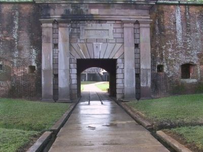
Near Bienville Boulevard east of Albatross Street, on the right when traveling east.
When British forces arrived at Mobile Bay to assault Fort Bowyer on Mobile Point, half of the British army under the command of Sir John Kean, who was recovering from wounds suffered during the defeat at New Orleans, was landed on Dauphin Island to . . . — — Map (db m122427) HM
Near West Markham Street at Ashley Street, on the right when traveling west.
To the Honor and Glory of our Patriotic Sires who gave their services for their country in the War of 1812-1815 • • • This tablet is dedicated in gratitude and pride by the National Society of the United States Daughters of 1812 State of Arkansas . . . — — Map (db m157499) WM
On Scott Street at East 7th Street, on the right when traveling north on Scott Street.
On this site stood the home of
Robert Crittenden
Lieutenant in the War of 1812
First Territorial Secretary of State
and Acting Governor of Arkansas
1819 – 1829 — — Map (db m211339) HM
In Memory Of The Men And Women
Who Served With Honor With The Naval
And Marine Forces Of The United States
Of America During The World War
1917 — 1919 — — Map (db m117236) WM
Commissioned in 1809 by U.S. President Madison, Frederick Lee served in the U.S. Revenue Cutter Service until 1829, providing security for the New Haven port and protection of American Ships on Long Island Sound.
On October 10, 1814, . . . — — Map (db m243260) HM WM
On Constitution Avenue Northeast (Alternate U.S. 1) at 2nd Street Northeast, on the right when traveling west on Constitution Avenue Northeast.
Residence of Albert Gallatin, Peace Negotiator and Secretary of the Treasury 1801-1814, who negotiated the treaty of Ghent, 1814. When the British marched on Washington in the summer of 1814, some American patriots with Commodore Joshua Barney and . . . — — Map (db m61571) HM
Born 1784-Died 1854. Captain Mounted Rangers, War of 1812.
1813-1815, U.S. Congressman from Kentucky
1821-1822, U.S. Judge, Eastern Florida.
1822-1834, First Civil Governor of Territory of Florida.
1838-1839, Member, Constitutional . . . — — Map (db m57597) HM
On West Flagler Street at NW Miami Court, on the left when traveling east on West Flagler Street.
Born 1793 in Virginia. Joined 12th U.S. Infantry in 1813; Served with it thru War of 1812; In 4th Regiment rest of his life. Promoted from 3rd Lieut. to Major, Commanded garrison at Key West. In Seminole War was sent with 117 men to aid Gen. Clinch . . . — — Map (db m88531) HM
On Woolfolk Street at Smith Street, on the right when traveling east on Woolfolk Street.
As U.S. Army and Georgia Militia Headquarters, Fort Hawkins played a significant role in the War of 1812. The fort supplied all command and logistics support for the Southern Theatre and fort personnel participated directly in the Creek War and The . . . — — Map (db m59575) HM
On Spinnaker Road at USS Kamehameha Avenue, in the median on Spinnaker Road.
In 1795 a cannon battery constructed on the Point Peter peninsula became the southernmost fortification in the First System of U.S. coastal defenses. Vacated in 1802, it was reoccupied and strengthened in 1808 to provide support for the enforcement . . . — — Map (db m16320) HM
Near College Avenue at 3rd Street (Illinois Route 127), on the left when traveling west.
In memory of the
who are buried in
Bond County
Amos Balch • Ansel Birge
Welshier Buchanan • William Burgess
Allen Comer • John Etzler
Daniel Ferguson • John Floyd
Boling Grigg • Bonham Harlan
T. S. Hubbard • Joseph Hunter . . . — — Map (db m34127) HM
On Calumet Ave at 18th Street, on the right on Calumet Ave.
From roughly 1620 to 1820, the territory of the Potawatomi extended from what is now Green Bay, Wisconsin, to Detroit, Michigan, and included the Chicago area. In 1803, the United States government built Fort Dearborn at what is today Michigan . . . — — Map (db m67806) HM
On East Adams Street west of Sixth Street, on the left when traveling west.
To Honor the Soldiers of the War of 1812
who lie buried in Sangamon County
First Column:
Roswell Abel • James Adams • William Archer • James Baker • Jacob Baker • Eli Barbre • Isaac Bates • Oliver Bates • Amor Batterton • Philo Beers . . . — — Map (db m46175) WM
On Battleground Avenue west of Railroad Street, on the right when traveling north.
Here, on this site, military forces commanded by General William Henry Harrison, engaged in battle with the Indians of the Wabash country led by The Prophet, brother of the great Indian leader, Tecumseh. This battle destroyed forever the hope of . . . — — Map (db m36205) HM
On Dixie Highway / Main Street (U.S. 31W) south of Union Street (State Road 357), on the left when traveling south.
1784 1815
Born 1784, Died 1813. Brought in childhood from Hagerstown, Md. to Lexington, Ky. Successful in both law and mercantile business. In 1812 raised and commanded Lexington Light Infantry; with his company went to Northwest Territory; . . . — — Map (db m39986) HM
On West St. Bernard Highway (State Highway 46) at Battlefield Road, on the right when traveling east on West St. Bernard Highway.
Site of the last major battle of the War of 1812 fought on January 8, 1815. Forces under the command of General Andrew Jackson defeated the British forces under the command of General Sir Edward Pakenham. This victory saved the city of New Orleans, . . . — — Map (db m147344) HM
[Main Marker]:
This monument was erected by the State of Louisiana and the United States to commemorate the memorable victory won here by General Andrew Jackson and the men under his command in the Battle of New Orleans, January 8, 1815. . . . — — Map (db m59218) HM
Near Main Street north of St. John Street, on the right when traveling north.
These six men of the 2nd Division 13th Regiment Louisiana Militia fought at the Battle of New Orleans during the War of 1812 and are buried in unmarked graves Auguste Badeaux Samuel Ott William Cooper Charles Parent, Jr. . . . — — Map (db m99727) WM
Erected 1808.
Transferred to the Navy Department 1845.
Demolished 1909.
In memory of men who served at Fort Severn during the War of 1812. — — Map (db m7739) HM WM
The public spirited woman who made the 15 star flag that flew over Fort McHenry September 14, 1814, inspiring Francis Scott Key to write the Star Spangled Banner.
Site restored 1976 by the U.S. Daughters of 1812 and the Star Spangled Banner Flag . . . — — Map (db m89205) HM WM
Near Constellation Plaza, 0.1 miles east of Wallace Street, on the right when traveling east.
This tree dedicated to Francis Scott Key who was inspired to write our National Anthem — The Star Spangled Banner — by the flag which flew from Fort McHenry during its bombardment. — — Map (db m145550) HM
On School House Lane, on the right when traveling west.
Erected to honor the heroism of the men who so bravely defended Fort Duffy and Fredericktown against the British Fleet May 5, 1813 Colonel Thomas Ward Veazey, commanding
Samuel Wroth; D.F. Heath; Moses Cannon; Nicholas Franks; John W. . . . — — Map (db m155571) WM
On Mount Calvert Road, 2.4 miles east of Croom Road (Maryland Route 382), on the right when traveling east.
Near this place the first courthouse in Prince George's County was erected in 1698, which served as the center of county government until 1721, when the county seat was moved to Upper Marlborough. The village of Charles Town was built on a tract of . . . — — Map (db m68085) HM
During the War of 1812, the bombardment of Baltimore, Maryland took place September 13-14, 1814. Dr. William Beanes was held prisoner aboard the British flagship of Vice Admiral Edward Cochrane. Francis Scott key and John Skinner were charged with . . . — — Map (db m69428) HM
On Washington Boulevard at Michigan Avenue (U.S. 12) on Washington Boulevard. Reported permanently removed.
Hardship struck soon after American troops regained Detroit on Sept. 29, 1813, during the War of 1812. Soldiers' quarters were lacking, and food supplies became desperately short. Then a disease resembling cholera broke out among the soldiers. By . . . — — Map (db m172528) HM
On Jessup Drive West just south of Veterans Memorial Parkway, on the right when traveling south.
300 yards south — built 1798 on Spanish grant. Homestead of Major Nathan Heald, Commander Fort Dearborn, War of 1812, and his wife Rebecca Wells from 1817 to 1853. — — Map (db m169554) HM
On John J Pershing Dr at Hummel Rd, on the left when traveling north on John J Pershing Dr.
Built near this site in 1807 by Manuel Lisa, trader and indian commissioner, through whose influence the Omaha, Pawnee, Ponca, Otoe and Sioux tribes remained loyal to the United States during the War of 1812. — — Map (db m7892) HM
On Butterville Road (County Route 75) north of John's Lane, on the left when traveling north.
Route traveled by the men who carried the four-ton cable for the ship "Superior" twenty miles from Sandy Creek Battlefield to Sackets Harbor in June 1814. — — Map (db m86193) HM
On New York State Route 289 at Lee Road, on the right when traveling north on State Route 289.
Route traveled by the men
who carried the four-ton cable
for the ship "Superior" twenty miles
from Sandy Creek Battlefield
to Sackets Harbor in June 1814. — — Map (db m86186) HM
In Memory of
the officers and men who
served on this frontier
during the War of 1812, and
to mark the Battlefield of
Sackets Harbor May 29, 1813.
This monument is erected
by the National Society of
United States Daughters of
1812, . . . — — Map (db m75690) WM
On Smithville Road (County Route 75) north of New York State Route 3, on the right when traveling north.
Route traveled by the men
who carried the four-ton cable
for the ship "Superior" twenty miles
from Sandy Creek Battlefield
to Sackets Harbor in June 1814. — — Map (db m86204) HM
On Arsenal Street (New York State Route 3/12) at Sherman Street, on the right when traveling east on Arsenal Street.
Created March 28, 1805 - named for
Thomas Jefferson
Born 1743, Died 1826.
President of United States 1801-1809
Vice-President 1797-1801
Secretary of State 1790-1794
Minister to France 1784-1789
Governor of Virginia 1779 . . . — — Map (db m110075) HM
On Main St. W at Fitzhugh St, on the right when traveling east on Main St. W.
Created February 23, 1821 - Named for James Monroe
Born April 28, 1758, Virginia - Died July 4, 1831, New York
Major in the American Revolution - Senator from Virginia
United States Minister to France and England
Twice Governor of Virginia - . . . — — Map (db m57092) HM
On E 10th Street at Stuyvesant Street, on the left when traveling east on E 10th Street.
Son of a revolutionary patriot Born in Fox Meadows (Now Scarsdale) N.Y. June 21, 1774 Died in Tompkinsville, Staten Island N.Y. June 11, 1825 Governor of New York State 1807-1817 — Vice President of the United States 1817-1825 Military . . . — — Map (db m41207) HM
On Amsterdam Avenue south of W 118th Street, on the right when traveling south.
To commemorate New York City Defenses During the War of 1812 Barrier gate McGowan’s Pass, Barrier Gate Manhattanville, Forts Clinton, Fish, and Haight, and three stone towers. --•-- Also in honor of Maj. Gen. Garrit Hopper Striker (then . . . — — Map (db m53967) HM
On Lower River Road (New York State Route 18F) south of Pletcher Road, on the left when traveling north.
British troops commanded by
Col. Murray landed December 19,
1813 on shore of river - marched
north - captured Fort Niagara
holding it until May 22, 1815. — — Map (db m67338) HM
On Center Street (New York State Route 18F) at Portage Road, on the left when traveling west on Center Street.
In honor of the brave members of the Tuscarora Nation who defended and saved local residents during the war of 1812. On the morning of December 19, 1813, Lewiston was attacked by British forces and their Native allies from Canada. The British had . . . — — Map (db m231271) WM
On New York State Route 14, on the right when traveling north.
On the brow of this hill took place the battle of Sodus Point between the British and American forces June 19, 1813. The following day the village of Sodus Point was sacked and burned by the British. — — Map (db m129832) HM
On Washington Street at Mill Street, on the right when traveling west on Washington Street.
From the nearby ravine,
the militia and volunteers hastily gathered under General Swift, bravely defended the northern frontier, their kindred and homes, from the attack of the British at Pultneyville, May 15, 1814 — — Map (db m79596) HM WM
On Fort Amanda Road at Sunderland Road, on the right when traveling west on Fort Amanda Road.
Site of the 86 acre homestead of Dye Sunderland who served in Captain Samuel McCormick's Company of The War of 1812
Here in 1820, on the site of the Indian town of Tawa the Sunderland family established the First Permanent Home in . . . — — Map (db m91455) HM
On Ohio Route 198, 0.2 miles south of Deep Cut Road (Local Highway 230), on the right when traveling north.
In Memory Of
The 75 Unknown American Soldiers
of the War of 1812
buried in this cemetery.
Death came to these Patriots ether while on duty
at For Amanda or while in the Fort Hospital to
which wounded were returned from the forward
area. . . . — — Map (db m167040) WM
On East River Drive (Ohio Route 424) west of Maywinn Road, on the right when traveling east.
[Front Text on Marker] : "Winchester's Camp #2"
After completing Fort Winchester, Brigadier General James Winchester ordered his troops to cross to the north side of the Maumee River. The troops occupied the new site, Camp #2, from . . . — — Map (db m54318) HM
On Ohio Route 424, 1.1 miles east of Indepedence Road (County Route 185), on the right when traveling east.
[Front Text] : "Winchester's Camp No. 3/Fort Starvation"
Camp No. 3 was located about six miles below Fort Winchester on the north side of the Maumee River. Militiamen from Kentucky, part of the forces led by War of 1812 Brig. Gen. . . . — — Map (db m37924) HM
On Old Military Road at North Greenfield Road (County Road 7), on the right when traveling north on Old Military Road.
Boughton Road Northwest from this point follows the route of a military road opened by General Reason W. Beall in 1812. This trail was used to move troops and supplies between Wooster and Lower Sandusky (now Fremont), Ohio during the War of 1812. — — Map (db m221592) HM
[Left Historical Marker]:
This Land Office was established by Congress
on May 10, 1800.
President John Adams appointed David Hoge
as Land and Title Registrar, which position
he held for forty years.
In 1801 Mr. Hoge bought the . . . — — Map (db m46886) HM
Near Adams Street east of North Michigan Street (Ohio Route 25), on the left when traveling east.
Son of the Pioneers, born 1781. Recruited twenty Ohioans for duty in case of war with Spain over Louisiana Purchase. Brigadier General, 2nd. Brigade, 2nd. Division, Ohio Militia in War of 1812. Governor of Ohio 1832-36; enacted first laws . . . — — Map (db m121994) HM
On Windemere Boulevard at Manhattan Boulevard, on the right when traveling east on Windemere Boulevard.
Famous Scout Whose loyalty, courage, and resourcefulness aided the United States in retaining this territory during the War of 1812 – 1815. His grave is 400 feet south of this spot. This memorial erected October 6, 1923. by The Peter Navarre . . . — — Map (db m19552) HM
On East Bay Shore Road close to Seneca Trail, on the right when traveling east.
[Marker Front]:
In memory of
Mason, Simonds, & Mingus.
Who fell near this place
in battle with the Indians.
Sept. 29, 1812.
[Marker Side]:
This Monument was erected in 1857 by Joshua R. Giddings . . . — — Map (db m18978) HM
On North Paint Street near East Main Street (U.S. 50), on the left when traveling north.
The state of Ohio was made possible by the treaty of Paris, 1783, which made the great
lakes the northern boundary of the new United States. In 1787 congress established the
Northwest Territory, dedicated to freedom and public education, with . . . — — Map (db m221650) HM
Near East Court Street east of North Prospect Street, on the left when traveling east.
Born 1783 New York City. Killed in combat September 1814. West Point Graduate 1806. As Military Engineer Helped build Castle Williams, N.Y. and Ft. Norfolk Va. Honored by naming of Fort Wood in New York Harbor and monument at West Point.
He . . . — — Map (db m120920) HM
On Adair Street at NE 1st Street, on the right when traveling north on Adair Street.
Pryor Creek was named in honor of Nathaniel Hale Pryor. Captain Pryor was a member of the Lewis and Clark Expedition, a veteran of the war of 1812 and was a Captain at the Battle of New Orleans, January 8, 1815. In June he was honorably discharged . . . — — Map (db m68099) HM
Near State Highway 101, 1 mile north of East 1040 Road, on the right when traveling north.
Honoring
Sequoyah (George Guess)
Veteran War of 1812
Marked October 1985
By
Pvt. Jacob Holley Chapter
United States Daughters of 1812 — — Map (db m141918) WM
On Fifth Avenue at Smithfield Street, on the right when traveling north on Fifth Avenue.
Established in 1804, it was the first air foundry in Pittsburgh. During the War of 1812, it supplied cannons and ammunition, primarily destined for the fleet on Lake Erie. In 1835, the first locomotive steam engine made west of the Alleghenies was . . . — — Map (db m94741) HM
On June 18th, 1812, the United States Congress declared war on Great Britain, at the request of President James Madison. The British had blockaded the U.S. coast, seized American ships, and impressed their seamen. Also, the Canadians supported . . . — — Map (db m136458) HM
On Germantown Avenue, on the right when traveling north.
In memory of soldiers of the War of 1812 who lie in upper Germantown Burying Ground Philadelphia William Crout • George Knorr • Jacob K. Knorr • Lewis Lehman • John Nell • John Poulson • Frederick Scheetz • Edward Snyder • Michael Snyder • George . . . — — Map (db m46872) WM
(Front text) On June 18, 1812, the United States declared war against Great Britain. One of the first units to be mustered into service was the Third Regiment of South Carolina Militia, which was stationed at Haddrell's Point, west of here, . . . — — Map (db m39505) HM
On ( SC-64 )Charleston Hwy, on the right when traveling west.
This U.S. Naval officer was born in Maryland
in 1782 and died at his plantation in St.
Bartholomew's Parish, S.C. in 1823. He served
as acting captain of the frigate "Constitution" in
1804 during the war with Tripoli, and was senior
officer . . . — — Map (db m7881) HM
On Georgia Avenue just north of East 7th Street, on the left when traveling north.
Hamilton County
created October 25, 1819, named for
Alexander Hamilton
born January 11, 1757; died July 12 1804. Aide de Camp to
Gen. Washington at twenty: member of Continental Congress at
twenty-five; captain in Revolutionary War; a leader in . . . — — Map (db m150512) HM
Near Court Street east of North Kentucky Street (Tennessee Highway 58), on the left when traveling east.
To the Glory of God
and in loving memory of
the American soldiers and
sailors of the War of 1812
who enlisted here.
This tablet is erected by
the Tennessee National
Society United States
Daughters of 1812 and the
Court of Roane . . . — — Map (db m42950) WM
Near Natchez Trace Parkway (at milepost 426.3), on the right when traveling north.
This Monument memorializes War of 1812 soldiers buried along the Old Natchez Trace, and it honors the service of all brave volunteers who marched on the Natchez Trace during the War of 1812 to help establish American Independence.
The Natchez . . . — — Map (db m83188) HM
On State Highway 35 at Half Moon Drive (State Highway 238), on the right when traveling east on State Highway 35.
This hexagonal, three-story cypress building sat on a platform supported by piles in Matagorda Bay. Supplies were brought twice yearly to this lighthouse, whose beacon extended 12 miles to warn mariners of sandbars and reefs. Restoration was a . . . — — Map (db m195693) HM WM
On West Weatherford Street (State Highway 347 Spur) at Main Street, on the left when traveling east on West Weatherford Street.
Born 1796, died at Fort Belknap 1858. Veteran of War of 1812, active in Battle of New Orleans. Veteran of Texas War of Independence 1836, Commander of Ranger Forces of Northwest Frontier 1837. Representative from Red River District in Congress of . . . — — Map (db m52516) HM
“I shall never surrender or retreat”
Travis
Edward, James, George,
sons of Anson Taylor
died at the Alamo
March 6, 1836
Taylor County was named
for these gallant men
Erected by the John Hudnall Chapter of the . . . — — Map (db m79762) HM
On West Queens Way just west of West Queens Court, on the right when traveling west.
Private Thomas Bradley 1774-1826 •
Sergeant Major Mark L. Chevers 1795-1875 •
Sergeant William Face 1770-1855 •
Lieutenant James M. Glassell 1790-1838 •
First Sergeant Timothy Green 1782-1847 •
Private Richard S. Hicks 1793-1868 • . . . — — Map (db m166543) HM WM
Revolutionary War Patriots and War of 1812 Veterans known to be interred in Historic Dumfries Cemetery
Revolutionary War
QM Timothy Brundige 1754 - 1822 •
PVT George Smith 1765 - 1822 •
Patriot Thomas Cave 1745 - 1802 •
PVT William . . . — — Map (db m85566) WM
Near Hospital Street at North 4th Street, on the left when traveling west.
This monument is dedicated to the memory of the more than 27 Patriots of the American Revolution and 400 veterans of the War of 1812 buried in this cemetery. Their loyalty, faith, courage and self sacrifice in servicing our country preserved the . . . — — Map (db m79709) WM
Near N Witchduck Road, 0.2 miles north of Cathedral Drive.
CAPT Adam Thorowgood (1604-1640) Founder
COL Thomas Walke I (1642-1694) Colonial War
COL Edward Moseley (1661-1736) Colonial War
COL Anthony Walke I (1692-1768) Colonial War
COL Edward Hack Moseley (1717-1783) Colonial War
Lt COL . . . — — Map (db m135219) HM WM
In Memory of the American Prisoners of the War of 1812 who died in Bermuda
Jean Baptiste · James Boon · Peter Burn · Richard Dale · Joseph Darby · William Demers · Thomas Dunton · Charles Gerlock · Howe Hanson· Hugh Hendrik · Samuel Henry · . . . — — Map (db m163619) HM WM