After filtering for Indiana, 247 entries match your criteria. The first 100 are listed. ⊳
Native Americans Topic
By Dale K. Benington, April 6, 2010
The Wayne Trace Marker
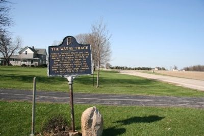
| 1 ► Indiana, Adams County, Decatur — 01.1977.1 — The Wayne Trace — |
| 2 ► Indiana, Allen County, Fort Wayne — First Americans — |
| 3 ► Indiana, Allen County, Fort Wayne — Little Turtle — |
| 4 ► Indiana, Allen County, Fort Wayne — Maumee - Wabash Portage — "Glorious Gate" — |
| 5 ► Indiana, Allen County, Fort Wayne — Miami Legend of the Sandhill Crane — |
| 6 ► Indiana, Allen County, Fort Wayne — The Floods — |
| 7 ► Indiana, Allen County, Fort Wayne, Bloomingdale — Fort Wayne ~ Fort Dearborn Trail — |
| 8 ► Indiana, Allen County, Fort Wayne, East Central — The Last Two American Forts / The Siege of 1812 — |
| 9 ► Indiana, Allen County, Fort Wayne, East Central — The Site of General Wayne's Fort — Dedicated October 22nd 1794 — |
| 10 ► Indiana, Allen County, Fort Wayne, East Side Community — Wayne Trace — |
| 11 ► Indiana, Allen County, Fort Wayne, Northside — Kekionga — |
| 12 ► Indiana, Allen County, Fort Wayne, Northside — The Battle of Harmar's Ford — |
| 13 ► Indiana, Allen County, Fort Wayne, Northside — The Battle of Kekionga — |
| 14 ► Indiana, Allen County, Fort Wayne, Spy Run — Chief Little Turtle — 1752 - 1812 — |
| 15 ► Indiana, Allen County, Fort Wayne, Spy Run — Little Turtle — |
| 16 ► Indiana, Allen County, Fort Wayne, Spy Run — Meshekinnoquah — (Chief Little Turtle) — |
| 17 ► Indiana, Allen County, Fort Wayne, Spy Run — The Headwaters of the Maumee River — |
| 18 ► Indiana, Allen County, Fort Wayne, Spy Run — William Wells — |
| 19 ► Indiana, Allen County, Fort Wayne, West Central — Cathedral of Immaculate Conception — |
| 20 ► Indiana, Allen County, Fort Wayne, West Central — Post Miami — The Site of the First French Fort — Built about 1680 — |
| 21 ► Indiana, Allen County, Fort Wayne, West Central — Richardville — 1761 - 1841 — |
| 22 ► Indiana, Allen County, Hoagland — Hoagland, Indiana — Platted 1872 — Wayne Trace — |
| 23 ► Indiana, Allen County, Levert — 02.1966.1 — Site of Hardin’s Defeat — Reported permanently removed |
| 24 ► Indiana, Benton County, Fowler — Indian Boundary Line — 1818 to 1832 — |
| 25 ► Indiana, Benton County, Fowler — 04.1966.1 — New Purchase Boundary — (Treaty of St. Mary's) — |
| 26 ► Indiana, Blackford County, Montpelier — 05.1989.1 — Godfroy Reserve — |
| 27 ► Indiana, Boone County, Thorntown — 06.1961.1 — Indian Cemetery — Eel River Tribe of Miamis — |
| 28 ► Indiana, Carroll County, Burlington — Burlington — |
| 29 ► Indiana, Carroll County, Delphi — Constructing the Wabash & Erie Canal — 468 Miles of Hard Labor — Wabash & Erie Canal Park Village — |
| 30 ► Indiana, Carroll County, Delphi — 08.1966.1 — New Purchase Boundary — (Treaty of St. Mary’s) — |
| 31 ► Indiana, Carroll County, Delphi — Trail of Death — September 10, 1838 — "Winnemac's" Old Village — |
| 32 ► Indiana, Carroll County, Pittsburg — Trail of Death — Pleasant Run — |
| 33 ► Indiana, Carroll County, Pyrmont — Pyrmont / 1812 Hopkins’ Expedition — |
| 34 ► Indiana, Carroll County, Wheeling — Sycamore Row — |
| 35 ► Indiana, Cass County, Adamsboro — Former Miami Indian Village — |
| 36 ► Indiana, Cass County, Adamsboro — Wilkinson's Expedition / James Wilkinson (1757-1825) — |
| 37 ► Indiana, Cass County, Logansport — Potawatomi Encampment — Trail of Death — |
| 38 ► Indiana, Clark County, Charlestown — Ohio River: the Human Story — |
| 39 ► Indiana, Dearborn County, Aurora, Center Township — Lochry Massacre Memorial — |
| 40 ► Indiana, Dearborn County, Aurora, Center Township — Lochry Massacre Memorial — |
| 41 ► Indiana, Dearborn County, Aurora, Center Township — Site of Lochry's Defeat — |
| 42 ► Indiana, Delaware County, Muncie — 1827 — [The First School House in Delaware County] — |
| 43 ► Indiana, Delaware County, Muncie — Old Indian Trail / Wheeling Pike — |
| 44 ► Indiana, Delaware County, Muncie — This Boulder Marks the Traditional Site of Wah-Pe-Kah-Me-Kunk — |
| 45 ► Indiana, Delaware County, Muncie — Uten-Ink — “Old Town” — |
| 46 ► Indiana, Delaware County, Muncie, Downtown — Passing of the Buffalo — |
| 47 ► Indiana, Dubois County, Jasper — Dubois County Named in Honor of Toussaint Dubois — Abt. 1750-1816 — |
| 48 ► Indiana, Elkhart County, Elkhart — Elkhart River Old Indian Trail — |
| 49 ► Indiana, Elkhart County, Elkhart — The Rivers and the Native Americans — Our Rivers' Story — |
| 50 ► Indiana, Elkhart County, Goshen — The Site of Fort Beane — |
| 51 ► Indiana, Elkhart County, New Paris — Five Medals Village — |
| 52 ► Indiana, Fayette County, Connersville — John Conner — Born 1780 - Died 1826 — |
| 53 ► Indiana, Fayette County, Connersville — Twelve Mile Line — |
| 54 ► Indiana, Floyd County, New Albany — 22.1999.1 — Buffalo Trace Route — |
| 55 ► Indiana, Fountain County, Attica — 23.2003.1 — Ravine Park — |
| 56 ► Indiana, Franklin County, Brookville — 24.1995.3 — Intersection of Treaty Lines — |
| 57 ► Indiana, Franklin County, Metamora — Boundary Hill — The Greenville Treaty Line in Southern Indiana — Marking the “Gore” at the Whitewater Canal — |
| 58 ► Indiana, Fulton County, Rochester — Father Petit and the Potawatomi 'Trail of Death' — Indiana to Kansas, September 4 - November 4, 1838 — |
| 59 ► Indiana, Fulton County, Rochester — Ga bgojwébnegéjuk Mural — |
| 60 ► Indiana, Fulton County, Rochester — 25.1949.1 — Michigan Road — |
| 61 ► Indiana, Fulton County, Rochester — Potawatomi "Trail of Death" — Indiana to Kansas, September 4 - November 4, 1838 — |
| 62 ► Indiana, Fulton County, Rochester — Site of Indian Village Chippewa-Nung — Potawatomi - Trail of Death — |
| 63 ► Indiana, Fulton County, Rochester — Trail of Death — Mud Creek — |
| 64 ► Indiana, Fulton County, Rochester — William Polke House — |
| 65 ► Indiana, Fulton County, Rochester — William Polke Trading Post — |
| 66 ► Indiana, Gibson County, Princeton — Agriculture — 1,000 B.C. — Present — |
| 67 ► Indiana, Gibson County, Princeton — Early Settlers — 1789 — 1814 — |
| 68 ► Indiana, Gibson County, Princeton — Native Americans — 8,000 B.C. — 1811 — |
| 69 ► Indiana, Grant County, Jalapa — Chief Meshingomesia — 1781 - 1879 — |
| 70 ► Indiana, Grant County, Jalapa — Conner's Mill — |
| 71 ► Indiana, Grant County, La Fontaine — 27.1972.1 — Miami Indian Cemetery — |
| 72 ► Indiana, Grant County, Marion — 27.1947.1 — Battle of Mississinewa — Two miles west — Reported permanently removed |
| 73 ► Indiana, Grant County, Marion — Mississinewa Battlefield — |
| 74 ► Indiana, Grant County, Marion — 27.1966.1 — New Purchase Boundary — (Treaty of St. Mary’s) — |
| 75 ► Indiana, Grant County, Marion, Center Township — A Journey Begun — |
| 76 ► Indiana, Hamilton County, Strawtown — Archaeology in Action — Strawtown Koteewi Park — |
| 77 ► Indiana, Hamilton County, Strawtown — Details in the Dirt — Strawtown Koteewi — |
| 78 ► Indiana, Hamilton County, Strawtown — The Mock Excavation — Strawtown Koteewi Park — |
| 79 ► Indiana, Hamilton County, Strawtown — Welcome to Strawtown Koteewi Park — Strawtown Koteewi Park — |
| 80 ► Indiana, Hamilton County, Strawtown, White River Township — Daily Life Structure — Strawtown Koteewi Park — Koteewi Trace Adventures in Archaeology — |
| 81 ► Indiana, Hamilton County, Strawtown, White River Township — The Community Structure — Strawtown Koteewi Park — Koteewi Trace Adventures in Archaeology — |
| 82 ► Indiana, Hamilton County, Strawtown, White River Township — The Oliver Village Site — Strawtown Koteewi Park — Koteewi Trace Adventures in Archaeology — |
| 83 ► Indiana, Hamilton County, Strawtown, White River Township — The Stockade Wall — Strawtown Koteewi Park — Koteewi Trace Adventures in Archaeology — |
| 84 ► Indiana, Hamilton County, Strawtown, White River Township — Village Welcome — Strawtown Koteewi Park — Koteewi Trace Adventures in Archaeology — |
| 85 ► Indiana, Howard County, Greentown — The Miami Indian Village of Ma shock o mo — |
| 86 ► Indiana, Howard County, Kokomo — Chief Kokomo — Walk of Excellence — |
| 87 ► Indiana, Howard County, Kokomo — Manetoowa — |
| 88 ► Indiana, Howard County, Kokomo — The Burial Place of Chief Kokomo — Pioneer Cemetery — |
| 89 ► Indiana, Huntington County, Huntington — Chief Francis La Fontaine — (Topeah) 1810-1847 — |
| 90 ► Indiana, Huntington County, Huntington — 35.1972.1 — Forks of Wabash — |
| 91 ► Indiana, Huntington County, Huntington — 35.1966.1 — Home of Chief Richardville — |
| 92 ► Indiana, Huntington County, Huntington — 35.1979.3 — Huntington's Ford and First Bridge / Huntington's Buildings Over the River — |
| 93 ► Indiana, Huntington County, Huntington — Old Treaty Grounds — 1795-1846 — |
| 94 ► Indiana, Huntington County, Markle — Indian Mill Stone — |
| 95 ► Indiana, Huntington County, Roanoke — 35.2005.1 — Kiilhsoohkwa (Kilsoquah) — |
| 96 ► Indiana, Jackson County, Seymour — 10 O'Clock Indian Treaty Line — |
| 97 ► Indiana, Jackson County, Seymour — 36.1966.1 — Indian Treaty Corner — |
| 98 ► Indiana, Jackson County, Vallonia — 36.1951.1 — Fort Vallonia — |
| 99 ► Indiana, Jasper County, Rensselaer — 37.1964.1 — General Robert H. Milroy — |
| 100 ► Indiana, Jasper County, Rensselaer — 37.1971.1 — St. Joseph’s Indian Normal School — 1888–1896 — |
247 entries matched your criteria. The first 100 are listed above. Next 100 ⊳