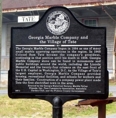
The Georgia Marble Company began in 1884 as one of many small marble quarrying operations in the region. In 1905 Colonel Sam Tate became the company's president, continuing in that position until his death in 1938. Georgia Marble Company stone can . . . — — Map (db m15019) HM
This County, created by Act of the Legislature December 18, 1857, is named for Franklin Pierce, New Hampshire Democrat and fourteenth President of the United States, 1853 to `57. He was a General in the Mexican War. Blackshear, incorporated . . . — — Map (db m24037) HM
Created by Act of Dec. 9, 1822, from Monroe County, Pike County originally contained part of Spalding, Upson and Lamar Counties. It was named for Zebulon Montgomery Pike (1779-1813), leader, in 1805, of an expedition to trace the Mississippi River . . . — — Map (db m59609) HM
Created December 20, 1851 and named for President James Knox Polk. Cedartown is fittingly named for the trees which flourish in this beautiful valley. The city is a railroad center, has a thriving textile industry, and a large paper mill. . . . — — Map (db m35738) HM
County seat of Paulding when that county was created in 1832; inc. 1838. Named for Isaac Van Wert & John Paulding, two of the captors of Major Andre.
Polk County was organized in 1851 from parts of Floyd and Paulding; this placed Van Wert in Polk . . . — — Map (db m35778) HM
This County, created by Act of the Legislature December 13, 1808, is named for Count Casimir Pulaski, Polish hero of the Revolutionary War who died fighting in Georgia and is buried in Savannah. Court was to be held at the home of Isham Jordan until . . . — — Map (db m40329) HM
This County, created by Act of the Legislature Dec. 10, 1858, is named for Gen. John A. Quitman, soldier in the Mexican War, Governor of Mississippi and ardent advocate of States Rights. The County Site is named for Georgetown, D.C. Among the first . . . — — Map (db m46586) HM
Randolph County was created by Act of Dec. 20, 1828 from Lee County. Originally Randolph County included all of what is now Stewart and Quitman and part of Terrell and Clay Counties. It was named for “John Randolph of Roanoke” (1773-1833), Virginia . . . — — Map (db m238725) HM
Originally designated as the Parish of St. Paul by the Act creating it in 1758, the name was changed in 1777 to Richmond County in honor of the Duke of Richmond, who, as a member of Parliament, was a zealous supporter of the American cause, . . . — — Map (db m9706) HM
This County, created by Act of the Legislature October 18, 1870, is named for Rockdale Church, so called for the fine underlying granite strata. Conyers, the County Site, was incorporated in 1854 and named for a prominent physician. Smyrna Camp . . . — — Map (db m35930) HM
Between 1765 and 1770 a group of settlers, mostly from North Carolina, settled and received grants for land in the vicinity of what is now Rockyford.
Among these first settlers were, Benjamin Lanier, Lemuel Lanier, Valentine Hollingsworth, . . . — — Map (db m13131) HM
According to a map "Plan of Donalson" dated April 1889, the town was laid out by John Earnest Donalson. On December 8, 1897, a charter, signed by Governor William Yates Atkinson, was granted incorporating the town of Donalsonville. Officers . . . — — Map (db m9858) HM
This County, created by Act of the Legislature July 8, 1920, is named for the Seminole Indians. Members of the Creek Confederacy, the Seminoles (meaning “separatist”) left the main body in Georgia and settled in Florida. After two bloody . . . — — Map (db m55645) HM
Spalding County was created by Act of Dec. 20, 1851 from Fayette, Henry and Pike Counties. It was named for Thomas Spalding (1774-1851), native of Frederica. One of the earliest cotton and sugar cane planters in Georgia, he was a legislator, state . . . — — Map (db m59619) HM
This County, created by Act of the Legislature August 18, 1905, is named for Alexander Hamilton Stephens, Vice President of the Confederacy. A state legislator and Senator he was elected to Congress at 31, serving from 1843 to 1859. Elected to . . . — — Map (db m58733) HM
First settled in 1827, Richland was named for the home district of several pioneer families from South Carolina. The community became a busy railroad junction when the Savannah. Americus and Montgomery, and the Columbus Southern rail lines met here . . . — — Map (db m10152) HM
This County, created by Act of the Legislature Dec. 5, 1801, is named for Josiah Tattnall, Governor of Georgia at the time, who signed the Act. There being no town in the new County, the Act provided that all public business be transacted at the . . . — — Map (db m170739) HM
Telfair County was created by Act of Dec. 10, 1807 from Wilkinson County. Originally, it contained parts of Coffee and Dodge Counties. It was named for Gov. Edward Telfair (1735- 1807). Born in Scotland, he settled in Savannah in 1766, was a . . . — — Map (db m23638) HM
This County, created by Act of the Legislature August 17, 1905, is officially named for Nelson Tift, well known businessman, legislator and Mayor of Albany. The organizers also had in mind his nephew Henry Harding Tift, who founded Tifton in 1872 . . . — — Map (db m39993) HM
Toombs County was created by Act of Aug. 18, 1905 from Emanuel, Montgomery and Tattnall. It was named for Gen. Robert Augustus Toombs 1810-1885), of Wilkes County, Congressman and Senator. One of the chief organizers of the Confederate government, . . . — — Map (db m18208) HM
Treutlen County was created by Act of Aug. 21, 1917 from Emanuel and Montgomery Counties. It was named for Gov. John Adam Treutlen (1726- 1782), "one of the foremost revolutionists." Elected Governor over Button Gwinnett in 1777, he was declared a . . . — — Map (db m23644) HM
This City of Monroe, settled in 1818 and incorporated Nov. 30, 1821, was named for James Monroe, fifth President. Born in Virginia in 1758 he fought in the Continental Army. He served in the Virginia legislature, in Congress and the Senate, and as . . . — — Map (db m20718) HM
This County, created by Act of the Legislature Dec. 19, 1793, is named for Gen. Joseph Warren, Massachusetts Revolutionary hero killed at the Battle of Bunker Hill. What is claimed to have been the first iron works and woolen mill in Georgia was . . . — — Map (db m49372) HM
This County, created by Act of the Legislature Aug. 14, 1912, is named for Gen. Joseph Wheeler, famous Confederate Cavalry leader and Major General of Cavalry in the Spanish War. He twice saved Augusta from Kilpatrick's Union Cavalry, at . . . — — Map (db m23634) HM
When White County was formed in 1857, Mt. Yonah was selected as the County-seat. The majority of its residents wished to rename it Sheltonville for William H. Shelton, who sponsored the formation of the new county. Shelton asked that it be named . . . — — Map (db m43702) HM
This County was created by Act of the Legislature Dec. 22, 1857. Georgia Archives show that it was named for Capt. John Wilcox though some authorities believe it was named for his son Gen. Mark Wilcox, state legislator and one of the founders of the . . . — — Map (db m40104) HM
Washington, Georgia
Incorporated January 23rd 1780
First incorporated city
in the United States
named for
our first president
Elevation 619 feet — — Map (db m200064) HM
This County was created by Acts of the Legislature May 11, 1803 and Dec. 7, 1805. It is named for James Wilkinson, Revolutionary General, and formed from part of the lands acquired from the Creeks by the Treaty of Fort Wilkinson (on the Oconee) at . . . — — Map (db m41869) HM
This County created by Act of the Legislature Dec. 20, 1853 is named for Maj. Gen. Wm. J. Worth of Mexican War fame under whose command served Maj. William A. Harris, a leader in the organization of the new County. Among the first County Officers . . . — — Map (db m40109) HM
The bay before you—named Keoneloa (or ‘the long sand’)—is the site of one of the oldest known Hawaiian occupation on Kaua‘i, a temporary fishing camp, dating to A.D. 220–660.
The Hawaiians divided each island into . . . — — Map (db m12807) HM
President Abraham Lincoln created Idaho Territory, appointed its first officers and judges and addressed Congress about Idaho in 1863 and 1864. He considered Idaho issues in the White House on the afternoon that he was shot and invited the former . . . — — Map (db m126722) HM
In memory of
Henry Horner
1878 – 1940
Judge of the Probate Court of Cook County
1914 – 1933
Governor State of Illinois
1933 – 1940
He Had Clean Hands And A Pure Heart — — Map (db m246005) HM
This Illinois - Indiana state boundary marker is one of the oldest landmarks in the Chicagoland area. It was constructed in 1838 under the direction of the United States Surveyor General to commemorate the establishment of the common boundary . . . — — Map (db m237902) HM
On October 7, 1871, the Great Fire of Chicago started on the south side of the city and continued north. As the fire approached Old Town, the bells of St. Michael’s Church began to toll. The walls of church survived, but the interior was destroyed. . . . — — Map (db m47605) HM
From 1870 through the 1800s, Henry Piper, one of Old Town’s early entrepreneurs, operated a successful bakery in a narrow alley. Today, the building at Wells and North is known as Piper’s Alley. The existing house located at 1546 North Wells was . . . — — Map (db m47609) HM
The Illinois Territory was formed in 1809. Its Governor, Ninian Edwards, laid out a district on Sept. 14, 1812 and called it the County of Gallatin. After Albert Gallatin, Secretary of the U.S. Treasury. The county changed size and shape often . . . — — Map (db m210685) HM
On April 12, 1842, Morris was confirmed as the site for the county seat of Grundy County. This tree is planted in commemoration of the 150th anniversary of the event. — — Map (db m239284) HM
The Mississippi River was a major superhighway throughout history, Native Americans traveled extensively on the waterway, and early settlers settled the Midwest by entering the port of New Orleans and traveling north on the river. During the . . . — — Map (db m226556) HM
January 6, 1816 — An Act of the legislature of the Illinois Territory was enacted to form a new county out of Randolph and St. Clair Counties to be called Monroe County named after then U.S. Secretary of State James Monroe who would be elected . . . — — Map (db m205551) HM
Known as Powell Press Building
This building, the oldest Commercial structure on Peoria's Riferfront, was saved, moved, and restored by City of Peoria. — — Map (db m9180) HM
Decatur was selected as a County Seat on May 18, 1836. The founders were Samuel Rugg and Thomas Johnson. Decatur was surveyed by Jacob Hofer. The land for the site was owned by Thomas Johnson. Decatur was selected by a special county board comprised . . . — — Map (db m211666) HM
First town incorporated in Maumee Township. Once called "Phelps Station" on the Wabash Railroad. A strategic point in a vast woodland of timber unsurpassed in the United States for variety and condition.
Incorporated as a 5th class city in . . . — — Map (db m193534) HM
Benton County formed by General Assembly in 1840. Oxford first county seat; Fowler became second, 1874. Designed in Second Empire Style by Gorden P. Randall and built 1874 by Levi L. Leach. Located at geographical center of county on land donated by . . . — — Map (db m21487) HM
In October 1818, Purchasing Commissioners Lewis Cass, Benjamin Parke and Governor Jonathan Jennings acquired Indian claims on the land shown on this marker. About one-third of modern Indiana, was involved in this transaction. — — Map (db m21517) HM
Formed by proclamation of Indiana Territorial Governor William Henry Harrison March 7, 1803. Named in honor of Major General Henry Dearborn, Secretary of War.
The third county to be formed, it was originally much larger. Its present boundaries . . . — — Map (db m22103) HM
The boundary between Indiana and Michigan territories was established in 1805. Just before Indiana became a state in 1816, the line was moved ten miles north to give Indiana frontage on Lake Michigan. — — Map (db m44849) HM
This marker depicts the Fayette County Courthouse as it appeared when built in 1849. Subsequent renovations resulted in its present appearance.
The Courthouse was listed in the National Register of Historic Places in 2006.
Connersville's . . . — — Map (db m152030) HM
Platted 1832
Addition 1836
Population in 1840 - - 800
First polling place in Davis Township.
Many years Largest Town South of Chicago. — — Map (db m9874) HM
Scott, Hultz, and Sigler commissioners appointed by State Legislature to form the newly formed Fountain County Seat of Justice, met here at William B. White Home.
He erected the County's first mill here near the covered bridge, the County's . . . — — Map (db m20411) HM
Platted 1808 along Whitewater River, Brookville was an important entry point to interior lands opened to settlement. The district's concentration of well-preserved buildings reflects the city's continued prosperity. Brookville Historic District . . . — — Map (db m44697) HM
Moorehead Communications, whose stores do business as TCC, has graciously helped CSA by
sponsoring Kenesow Mountain Landis, a brilliant communicator in his own right. This former
Marion resident helped clean up America's past time and became the . . . — — Map (db m215247) HM
Hamilton County formed 1823. Noblesville platted 1823, selected county seat 1824, incorporated 1851. Located east of downtown commercial area; boundaries are Conner and Logan streets (east and west) and 10th and 17th streets (north and south). . . . — — Map (db m240) HM
In loving memory
David J. Dukes, M.D.
July 16, 1927 — June 15, 1991
Remembered for his love of music, church, sailing, family, and his fellow man.
The bell predates the Civil War and may have been in the First Methodist Church around . . . — — Map (db m9686) HM
Corydon became the first state capital of Indiana in 1816. The first constitution was drawn up and the first sessions of the state legislature and supreme court convened here. — — Map (db m198385) HM
The Capital of Indiana Territory was moved to Corydon from Vincennes, 1813.
This building became first State Capitol, 1816.
Offices were moved to Indianapolis in 1825. — — Map (db m9626) HM
The story of Corydon begins the story of the State of Indiana.
Corydon lies in a valley between Big Indian and Little Indian creeks. The land had been purchased in 1804 by William Henry Harrison, who was then governor of the Indiana Territory. He . . . — — Map (db m207080) HM
(Side One) Residential district bounded by Main, East, Cross, and Marion streets. Nineteenth and early twentieth century homes reflect social and economic diversity of residents, including town’s prominent citizens. Listed in National Register of . . . — — Map (db m237) HM
Knightstown—first town platted on National Road after survey, 1827—named after noted surveyor Jonathan Knight.
Home of American Communications Network founded, in 1966, to preserve and perpetuate the “Ideals that built . . . — — Map (db m139247) HM
Henry County Courthouse 1869. The Henry County Courthouse, designed by architect Isaac Hodgson, replaced a courthouse that had burned in 1864. Featuring a mansard roof and a 110-foot clock tower, it is pictured on the inside covers of Ross . . . — — Map (db m200358) HM
This city, township and county were named for Samuel Huntington, signer of the Declaration of Independence and important political figure in the Revolutionary War era. Records indicate the name was given by Elias Murray, Huntington's nephew, when he . . . — — Map (db m71299) HM
The Old Courthouse has been, since its erection in 1878, a landmark in Lake County, Indiana. Construction of the central portion, including the clock tower, began with 500,000 hand-kilned bricks from the Henry Wise Brickyard in Crown Point, . . . — — Map (db m27806) HM
This marker is on the northern boundary of the Vincennes Tract, the first Indian cession obtained by Governor William Henry Harrison in the Indiana Territory.
The treaty was signed by chiefs of the Miami, Delaware, Shawnee, Potawatomi, Eel . . . — — Map (db m243588) HM
This Public Square was part of Chief Anderson's Delaware Indian Village. In 1827, thirty acres were donated to Madison County by John and Salley Berry to relocate the county seat from Pendleton to Anderson.
The remaining acreage was sold by . . . — — Map (db m232) HM
Naturalist/writer Gene Stratton Porter wrote more than 22 books and magazine articles about her experiences at Limberlost Swamp. The swamp encompassed 13,000 acres of Adams and adjacent counties before being drained and converted to farmland. — — Map (db m238844) HM
To protect early settlers, General Anthony Wayne destroyed the Miami tribe's village of Kekionga in 1794. Fort Wayne was later built at the junction of the three rivers which run through Allen County. John Chapman, also known as Johnny Appleseed, is . . . — — Map (db m238644) HM
Factories for automotive accessories and diesel engine production are the major industries in Bartholomew County. The largest city, Columbus, is known for schools, churches, and corporate buildings designed by world-renowned architects. — — Map (db m238980) HM
Primarily an agricultural community, Benton County produced the most famous horse in the history of harness racing. Foaled in Oxford, Ind., in 1896, Dan Patch set the record for the mile (1:55.25) at Lexington, Ky., in 1905. That record stood until . . . — — Map (db m238791) HM
Part of the late 19th century gas and oil boom, Blackford County's cities and towns expanded rapidly with the influx of industries which utilized these natural resources. Montpelier was known as "Oil City" for many years. — — Map (db m238935) HM
In the early 1900s, people from around the nation and world traveled through Boone County's rich farmland to view the courthouse in Lebanon. Built with 38-foot high columns, each carved from a single block of limestone, the courthouse is situated on . . . — — Map (db m238761) HM
In the fall, visitors flock to Brown County's oak, maple, hickory, and beech forests to view their brilliant colors. The county first gained fame as a mecca for artists and craftspersons who were inspired by the peace and beauty of these forested . . . — — Map (db m238945) HM
While much of Carroll County is level farmland producing soybeans, corn, and winter wheat, Freeman Reservoir's 2,800-acre lake provides a variety of recreational activities. Tiny white triangles represent boats sailing along its rippling blue waters. — — Map (db m238928) HM
By the Civil War, Cass County had become a significant Midwestern railroad center with several major lines such as the Cincinnati, Logansport, and Chicago intersecting the region. Travelers to Cass County were welcomed in Logansport (nicknamed . . . — — Map (db m238648) HM
At the falls of the Ohio River lies one of the world's greatest natural wonders, a 400-million-year-old fossil bed. Jeffersonville, located near the falls, is the largest inland boat building site in North America, producing cruise ships and . . . — — Map (db m238783) HM
Because the region has some of the state's richest coal deposits, mining in Clay County has been important since the 1850s. A fine grade of clay, discovered during the 19th century, provided raw material for a number of pottery and brick factories. — — Map (db m238939) HM
"Old Stoney" was opened in 1892 as a junior and senior high school. The building represents a rare combination of several architectural styles emulating a limestone, castle-like appearance. Six years after closing, "Old Stoney" reopened in 1980 as . . . — — Map (db m238922) HM
Wyandotte Cave, one of many caves hidden in the county's forested hills, contains the highest known underground mountain on earth, standing 135 feet tall. Native American tribes used the area as a source of flint for their points and tools. — — Map (db m238938) HM
A large Amish community farms the area northwest of Loogootee. Home to the Turkey Trot Festival, Daviess County has one of the largest turkey farms in the Midwest.
[The sculpture is located on this wall directly above.] — — Map (db m238932) HM
Thomas Gaff, a prominent industrialist and civic leader, built Hillforest Mansion on the Ohio River in the 1850s. The "Steamboat Gothic" architectural style includes features typical of the "floating palaces" that graced the nation's rivers during . . . — — Map (db m238857) HM
First noticed in 1870, large-tooth aspen trees have continually grown from the Decatur County Courthouse's 115-foot clock tower. Each September the community celebrates this unique phenomenon with the Tree City Fall Festival. — — Map (db m238757) HM
Although 80 percent of the county's land is used for farming, the city of Auburn was once a major center of the American automobile industry. More than 21 models of cars were created here, including the elegant Auburn and the classic Cord. — — Map (db m238992) HM
Muncie, the county seat, is named for Delaware Chief Munsee. Muncie is the industrial center of home canning equipment and glass food container manufacturing. Several area manufacturers opened factories as a result of the late 19th century gas boom . . . — — Map (db m238754) HM
In 1997, Dubois County produced 1,687,356 turkeys and ranked first among Indiana counties in raising poultry. Dubois County is also home to large manufacturers of pianos and organs, as well as office and home furniture. — — Map (db m238760) HM
More than 200 firms make mobile homes, campers, and other recreational vehicle-related products in Elkhart County. A center for musical instrument manufacturing, the county is known as the "band instrument capital of the world." In sharp contrast to . . . — — Map (db m238854) HM
Fayette County's original forests brought rise to many great early-1900s
cabinet manufacturers and distributors. The county seat of Connersville
was home to eight different automobile manufacturers, including
McFarlan and Lexington. — — Map (db m238647) HM
A popular site near New Albany, the limestone hills at Floyd's Knobs sit 900 to 1000 feet above sea level and 600 feet above the Ohio River. In 1867, New Albany was home to America's first plate glass factory, revolutionizing the glass industry and . . . — — Map (db m238916) HM
Many of Fountain County's residents are corn and soybean farmers, cultivating approximately 64 percent of its level terrain. The Portland Arch, a large sandstone natural bridge, is in the northwestern part of the county. — — Map (db m238788) HM
The Whitewater Canal, built in the mid-1800s, was used to transport farmers' produce to market and merchandise to local stores. An 80-foot-long aqueduct was built in 1848 to carry the canal 16 feet above Duck Creek on the eastern edge of . . . — — Map (db m238842) HM
Round barns, thought to be more efficient when feeding livestock, peppered Fulton County at the turn of the 20th century. Lake Manitou's popularity drew summer tourists to the area for its cottages, water sports, and large amusement park. — — Map (db m238943) HM
The Lyles Station community, named for Joshua Lyles, was home during the mid-19th to mid-20th centuries to more than 800 free African-American settlers. During the 19th century, large coal and oil reserves were discovered in Gibson County. It was . . . — — Map (db m238957) HM
Home of one of the world's largest popcorn producers, Grant County grows nearly 3,000 tons of popcorn annually. Grant County native James Dean was born in Fairmount. The 1950s American film idol had lead roles in "Rebel Without a Cause," "Giant," . . . — — Map (db m238763) HM
In 1906, the Illinois Central Railroad built one of the world's largest railroad trestles to span Richland Creek west of Solsberry. Still in use, the trestle is 2,295 feet long and 180 feet high. Also, the Worthington area once could claim the . . . — — Map (db m238841) HM
Hamilton County was once the home of the Delaware Native Americans. William Conner, an early trader, acquired land from the Delaware tribe and established a trading post on the White River. While recent years have seen southern Hamilton County . . . — — Map (db m238924) HM
Hoosier poet James Whitcomb Riley was born and raised in Greenfield. He wrote about life in Hancock County in poems such as "Little Orphant Annie" and "The Old Swimmin' Hole." — — Map (db m238793) HM
Nestled in Harrison County's wooded hills and pastures, Corydon holds significant importance in Indiana's history. The city served as capital of the Indiana Territory and then as the first Indiana state capital. In 1863, John Hunt Morgan's . . . — — Map (db m238855) HM
The first canned tomato juice, the first mechanical corn picker, and the first rubber tire pumped full of air originated in Howard County. Automobile headlights and automobile spark-ignition inventor Elwood Haynes helped earn Kokomo the title "City . . . — — Map (db m238946) HM
Three Native Americans pilot canoes, circumnavigating three currents. The Wabash and Salamonie rivers made this area a popular center for Native Americans, and in 1831, Chief Richardville moved the Miami capital to the Forks of the Wabash in . . . — — Map (db m238845) HM
The Jackson Washington State Forest offers spectacular vistas of wooded hills and filled fields. The tranquility was disrupted in the fall of 1866 when the nation's first train robbery took place near Seymour. The Reno Gang, who lived in Jackson . . . — — Map (db m238780) HM
Located on the migratory route of the sandhill crane, each fall tens of thousands of the large, beautiful birds stop to rest in the Jasper-Pulaski Fish and Wildlife Area, a habitat already teeming with wildlife. Composer James H. Hanley, writer of . . . — — Map (db m238933) HM
Home of the state's first drilled gas well, Jay County produced a variety of glass items at the turn of the 20th century. Dunkirk is generally referred to as the "glass capital of Indiana." The beautiful stained glass dome in the courthouse in . . . — — Map (db m238772) HM
1790 entries matched your criteria. Entries 201 through 300 are listed above. ⊲ Previous 100 — Next 100 ⊳