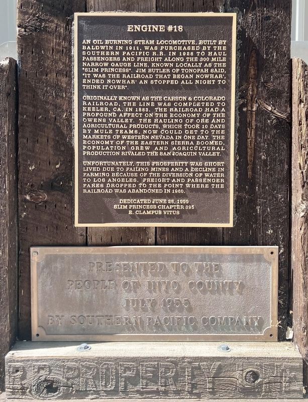
An oil burning steam locomotive, built by Baldwin in 1911, was purchased by the Southern Pacific R.R. in 1928 to haul passengers and freight along the 300 mile narrow gauge line, known locally as the “Slim Princess”. Jim Butler of Tonopah said, “It . . . — — Map (db m52099) HM
Built originally as a stagecoach depot in 1866, it evolved into a railroad station in 1883 to carry freight and passengers on the Carson & Colorado Railroad line, known locally as the "Slim Princess". It served the Independence community from 1883 . . . — — Map (db m72573) HM
From Mound House, Nevada, narrow gauge rails of the Carson & Colorado Railroad reached this site in 1883. Cerro Gordo and other mines faltered, the rail line fell on hard times, so plans to extend the line to Mojave were abandoned, leaving Keeler as . . . — — Map (db m72574) HM
In 1865 Pablo Flores found the richest vein of silver
California has ever had ($17 million) overlooking
Owens Lake at the crest of the Inyo Mountains. By 1868
Cerro Gordo Landing was growing to supply the mines.
Water went up the "Yellow . . . — — Map (db m221858) HM
The region yielded other resources as well, like grazing land, soda ash, trona, and borax. Weatherworn cattle chutes, abandoned mines and factories stand as testament to past human activity. Cerro Gordo remains a ghost town. In Keeler, the . . . — — Map (db m221908) HM
Located at Metbury Spring on the Tonopah and Tidewater Railroad, Shoshone was founded in 1910 by Ralph Jacobus "DAD" Fairbanks. After the collapse of the mining camp of Greenwater (approximately 20 miles northwest of here), "DAD" Fairbanks came to . . . — — Map (db m78511) HM
Situated at the southern end of the San Joaquin Valley, Kern County was part of a natural corridor for a railroad running between San Francisco and Los Angeles.
The Southern Pacific Railroad began laying track southward from San . . . — — Map (db m25117) HM
The Chinese community was an early and significant element of the population of Kern County.
Chinese immigrants contributed to the social, economic and industrial growth of Kern County by mining, farming, building railroads, and owning . . . — — Map (db m25318) HM
As railroad service expanded across the United States, railroads took precautions to ensure safe transportation for travelers and freight.
A railroad flagman notifies travelers of an approaching train and directs rail, automobile and pedestrian . . . — — Map (db m237366) HM
Railroad yards are highly specialized facilities consisting of engine maintenance buildings, fueling areas, track and switching areas and material storage yards.
This scale house was used in the Santa Fe Railroad switchyard in . . . — — Map (db m25636) HM
The caboose was an office, a lookout, and a home away from home for a train crew.
In the days before automatic air brakes, the engineer signaled the caboose with his whistle when he wanted to slow down or stop. A brakeman would then . . . — — Map (db m25598) HM
This locomotive, among the largest and most powerful on the Southern Pacific Railroad system, supported the growth and development of the San Joaquin Valley and the West.
Engine #2914, called a 4-8-0 because of its wheel . . . — — Map (db m25600) HM
Approximately 3,000 men labored on railroad construction up and over the Tehachapi Mountains in the 1870s.
It took over three years for the line to be completed through Kern County. As the railroad slowly progressed through the county, . . . — — Map (db m25606) HM
Named for Edward F. Beale, this station on the Southern Pacific rail line was established in 1876 as a depot and telegraph office. Service was discontinued in 1943. Beale was Superintendent of California Indian Affairs during the 1850’s. In 1865 he . . . — — Map (db m119218) HM
Originally known as Allen's Camp after Gabriel Allen, who in the 1870s had a cabin and stock pasture near here, the settlement was named Caliente when railroad construction reached this point in April 1875. The town became a railroad terminal for . . . — — Map (db m157683) HM
This building originally located four blocks southeast of
this site was opened for use and dedicated October 11, 1917.
Until closed in 1978, this building served as Shafter’s
gateway to the world as the mail, Western Union Telegraph,
express, . . . — — Map (db m130325) HM
Green Street was named for Peter D. Greene, who came to the Tehachapi Area in 1856, when he set up camp in Mormon Gulch near Tehachapi where he prospected for gold (named after a company of Mormons who had previously prospected for gold there.) He . . . — — Map (db m136213) HM
Built by Joe Gallinger in 1880, it was purchased in 1926 by Jim and Lucinda (Callie) Wiggins Brite. Upon Lucinda's death in 1944, the Davis family purchased the house. It was customary to drive sheep and cattle along Curry Street to the railroad . . . — — Map (db m52890) HM
1906-1914: City of Los Angeles builds and operates plant to make cement for Los Angeles Aqueduct and also constructs town named Aqueduct to house workers and families.
1910: Aqueduct train station and post office are renamed Monolith. . . . — — Map (db m52988) HM
This style of telephone booth was unique to Southern Pacific Railroad. Untold hundreds were manufactured at the West Oakland Maintenance of Way Shops. Inside each booth was a Western Electric model 1517 BU wood-encased telephone with a . . . — — Map (db m232280) HM
Erected in 1904 to replace a former depot destroyed by fire, the Tehachapi Depot served the community until its use as a station was discontinued in 1971. In 2004, a local group began the process of obtaining the depot from Union Pacific. Upon . . . — — Map (db m121882) HM
From this spot may be seen a portion of the world-renowned “Loop.” It was completed in 1876 under the direction of William Hood, Southern Pacific Railroad Engineer. In gaining elevation around central hill of loop a 4000 foot train will cross 77 . . . — — Map (db m134430) HM
The Tehchapi Loop put Tehachapi on the map when it was completed in 1876. Before that time there was no rail access across the Tehachapi Mountains. The historic Loop is pictured here, circa 1952, with a trompe l'oeil effect showing damage to the . . . — — Map (db m53117) HM
Tehachapi Pass became the preferred route connecting the Mojave and the San Joaquin Valley after John C. Fremont and Kit Carson passed this way during the 2nd Fremont Expedition in 1844. Situated at the southern edge of the Sierra Nevada, Tehachapi . . . — — Map (db m51786) HM
In front of you is the world famous Tehachapi Loop which is about halfway upgrade to the Tehachapi Pass. This steep line averages 2.2% in gradient in its 28 miles of length. This feat of civil engineering genius was crowning achievement of civil . . . — — Map (db m134431) HM
These bricks were discovered after the 2008 fire that destroyed the 1904 depot. They date back to the first depot built in 1876. They were collected and cleaned by museum volunteers. — — Map (db m232286) HM
In memory of conductor Everett S. Crown, brakeman Allan R. Riess, who lost their lives in a tragic train wreck in San Bernardino Calif. May 12, 1989.
Erected by employees and S.P.T.C.O. — — Map (db m141332) HM
On September 30th torrential rains flooded Tehachapi Creek, undermining the tracks under Santa Fe Engine No. 3834 which was waiting out the storm about ½ mile east of Woodford Station. The engine disappeared into the raging water below. It remained . . . — — Map (db m202039) HM
This was the first house constructed in Tehachapi, built in 1877 by Fred Boden. It was occupied from 1895 to 1940 by Mr. and Mrs. T.P. Sullivan. He was the Southern Pacific Roadmaster and was elected to Tehachapi's first Board of Trustees in 1909. . . . — — Map (db m52893) HM
The Tehachapi Pass played an important part in the race to build the first transcontinental railroad. In the south, construction was stopped at Caliente by what appeared as an insurmountable barrier, allowing the northern route through Donner Pass . . . — — Map (db m134561) HM
Here on May 11, 1880, during a dispute over land titles between settlers and railroad, a fight broke out during which seven men lost lives -- two deputy U.S. Marshals and five ranchers. Legal struggle over titles finally compromised. — — Map (db m154063) HM
From three livery stables in the
late 1800's to three gas stations in
the 1900's, Upper Lake kept up with
current modes of transportation.
Greyhound bus had a depot in Upper
Lake and there was at one time three
car dealerships in town.
There . . . — — Map (db m135524) HM
In memory of
An Unknown Soldier
who was buried here about 1870 on this the Old Military Road which ran from Ft. Bidwell in Modoc Co. to Ft. Crook, Shasta Co. — — Map (db m87821) HM
This building was part of the rail station from 1911-1958 of the Southern Pacific Line and was built by the Red River Lumber Company owned by the Walker Family. The Western Union and freight offices were a gathering place for local people. Leaving . . . — — Map (db m56713) HM
Named in honor of David J. MacPherson
who planned and engineered Mt. Lowe
Railway and Echo Mountain Incline,
in use 1893 to 1938. — — Map (db m153312) HM
Cable wheel, last remnant of Incline section, Mt Lowe Railway, Rubio Canyon to Echo Mt, 1893-1938, built by Prof. T.S.C. Lowe, D.J. Macpherson, engineer. — — Map (db m122608) HM
Mt. Lowe Scenic Railway was considered an engineering wonder
and southern California's most popular tourist attraction
during its heyday, carrying a total of 3.1 million visitors.
8th Wonder of the World
The brainchild of . . . — — Map (db m243446) HM
Trains were a prominent part of Arcadia for several generations from the late 19th century to the mid-1900s. With the tracks and depots of three of the most prominent and popular lines converging here, the Atchison, Topeka and Santa Fe Railway, . . . — — Map (db m207736) HM
Constructed about 1890 in Rancho Santa Anita by Atchison Topeka & Santa Fe Railroad on its transcontinental main line. Elias J. “Lucky” Baldwin donated right-of-way and bricks in exchange for agreement to stop trains, maintain a depot . . . — — Map (db m120309) HM
The view from Somerset (Bellflower) Boulevard in 1915, 10 years after the Santa Ana line first opened. On the left is PE substation #12. The Pacific Electric was an electrically powered interurban rail system. Power came from the company’s own . . . — — Map (db m133374) HM
With the 1907 extension of Huntington’s Pacific
Electric system through Duarte to Glendora,
a cut was created to level the railroad’s right
of way in front of L.L. Bradbury’s country home.
To provide access to his home, the site of which
is now . . . — — Map (db m137592) HM
When early settlers migrated to Southern California in the late 1800s, they saw the future potential of the fertile
valley located twelve miles north of Los Angeles. In 1867, Dr. David Burbank purchased the land, which, in
1911, would become . . . — — Map (db m137688) HM
The Atchison, Topeka & Santa Fe Railroad and its subsidiary, the Pacific
Land Improvement Company, founded the town of Claremont in 1887. The
railroad's original wooden, Gothic depot was replaced by this Spanish
Colonial Revival structure in . . . — — Map (db m149721) HM
Site of Glendale Depot of the
Los Angeles Interurban Railway, 1904-1923,
first six-story building in the city.
Constructed by Security Trust
and Savings Bank in 1923.
Original property occupied by
First Savings Bank of Glendale. — — Map (db m158123) HM
The Pacific Electric line was completed between Los Angeles and Glendora in December of 1907. The Red Cars provided transportation and freight service throughout Southern California. The Glendora Station became operational in 1908, but as personal . . . — — Map (db m138042) HM
In 1890 Andrew McNally purchased 2360 acres from the Stearns Ranchos for his La Mirada Colony of "country gentleman estates", and his Windermere Ranch. His plans were not fulfilled,
instead grew the McNally olive oil empire.
Nearby, to the . . . — — Map (db m236410) HM
Built in the early 1890's on Stage Road, the Train Depot was a significant part of La Mirada's early development. As new modes of transportation developed, the Train Depot became obsolete and was demolished in 1962. — — Map (db m236456) HM
This transportation kiosk salutes the past and future role of transportation in shaping the city of La Verne.
Founded by entrepreneur Isaac W. Lord in 1887 as one of a string of boom towns platted along the Santa Fe railway, the township of . . . — — Map (db m128943) HM
Santa Fe Coast Lines Hospital, first built in 1905, is a landmark in Boyle Heights and in the history
of industrial health care. It was established to serve the health care needs of railway employees,
who faced unusual risk of injury and other . . . — — Map (db m191109) HM
Canoga Park Southern Pacific Station, circa 1912.
Mission style. First railway station in the West Valley.
Historic-Cultural Monument No. 488, declared May 30, 1990, City of Los Angeles, Cultural Heritage Commission, Cultural Affairs . . . — — Map (db m165894) HM
Stoney Point Outcroppings natural site, considered one of the most
picturesque areas in Los Angeles.
Declared 1974, Historic-Cultural Monument No. 132, City of Los Angeles, Cultural Heritage Commission, Cultural Affairs Department. — — Map (db m163865) HM
Site of the historic River Station - terminus
of the Southern Pacific Railroad which
arrived here September 5, 1876, changing forever the "pueblo" character of Los Angeles.
Declared
Historic Cultural Monument No. 82
by the Cultural . . . — — Map (db m219681) HM
Built in 1901 by Colonel J. W. Eddy, lawyer, engineer, and friend of President Lincoln, Angel's Flight is said to be the world's shortest incorporated railway. The counterbalanced cars, controlled by cables, travel a 33 percent grade for 315 . . . — — Map (db m160015) HM
Flight of the Angels
As the trombones played on New Year's Eve in 1901, two wingless angels took flight, screeching their way to fame as the stars of the world's "shortest railway." "Olivet" and "Sinai," two black-trimmed, . . . — — Map (db m227811) HM
From 1901 until 1969, the Angels Flight funicular railway operated just north of this location, adjacent to the south side
of the Third Street tunnel. The flight was dismantled in connection with the re-grading phase of the Bunker Hill . . . — — Map (db m228648) HM
One of the oldest continuously operated
restaurants in Los Angeles. From this Pacific Electric building ran the world’s largest
interurban railway system.
Declared Historic-Cultural Monument No. 104 by the Cultural Heritage Board, . . . — — Map (db m167975) HM
Constructed by the Southern Pacific, Santa Fe and Union Pacific Railroads, opened on May 7, 1939. It was considered to be the most impressive railroad station of its type in the entire west.
In it's heyday the terminal covered 52 acres, . . . — — Map (db m171705) HM
Federal Emergency Administration
of Public Works Project No. 4561.
City of Los Angeles, Frank L Shaw - Mayor.
Board of Public Works...
Bureau of Engineering...
Members of the City Council...
General contractor: Bent . . . — — Map (db m229107) HM
The largest and most significant of the fourteen substations in the city, this brick power-transforming plant was built by the Los Angeles Railway Company to convert electricity from alternating current (AC) to direct current (DC) so as to provide . . . — — Map (db m122529) HM
Three railroads combined to build Union Station, which, when it was dedicated on May 7, 1939, was the last of the great trains stations to be built in this country. Architects John and Donald Parkinson used Streamline Moderne and Mission . . . — — Map (db m155811) HM
Riding the Rails into History
Union Station, a
monument to the
entwined elements
of history and
transportation, is
the last of the great
train stations built
in the nation, and
the major entry point
to Los Angeles, . . . — — Map (db m228025) HM
Built in Spanish-Colonial style on an
Indian village and later Chinese town site
by Southern Pacific, Santa Fe
and Union Pacific railroads.
Declared Historic Cultural Monument No. 101
by the Cultural Heritage Board, Municipal Arts . . . — — Map (db m164664) HM
Early Communities
The Tongva Indians named this area Otsungna (Place of Roses) for the wooded roses (Rosa californica).
1771 - Spanish Franciscans call a small river "El Rio Rosa de Castilla (Stream still exists along . . . — — Map (db m230082) HM
The Soto Street Bridge was constructed in 1936 to separate vehicular traffic from the Pacific Electric
railroad. Railroads were first introduced to the intersection in 1909 when Pacific Electric, under the
leadership of Henry Huntington, . . . — — Map (db m228371) HM
Automatic Block Signaling (ABS) was developed in the late 19th century to allow multiple trains to operate safely in the same direction without the risk of rear-end collision. In an ABS system, the track is divided into segments (“blocks”) and . . . — — Map (db m223092) HM
The Pacific Electric was once the largest and most varied interurban railway in North America. Its lines developed growth patterns throughout Southern California that are still evident today.
Before you is a waiting shelter from the Rio . . . — — Map (db m222370) HM
The "T-2" style of signal was first offered by the Union Switch & Signal Company in 1912 - combining a moving semaphore blade for daytime indication and colored lights for nighttime indication. The aspect (appearance of the signal) is changed by . . . — — Map (db m223093) HM
The first permanent railroad track in the United States was laid around 1810 near Philadelphia. Experimental railways began developing throughout the eastern states and by 1850 over 9,000 miles of track had been laid. Track construction followed the . . . — — Map (db m144012) HM
Highland Park is Established
Highland Park is one of the oldest communities
in Los Angeles. The first subdivision in the area
was the Hunter Highland View Tract, developed
by Albert H. Judson and George W. Morgan.
It was followed . . . — — Map (db m228135) HM
Constructed by California Southern Railroad (a Santa Fe subsidiary),
built 1896.
Declared 1988, Historic-Cultural Monument No. 339, City of Los Angeles, Cultural Heritage Commission, Cultural Affairs Department. — — Map (db m205594) HM
Intersection of York & Figueroa
York Junction is the name given to the intersection of York Boulevard and North Figueroa Street and the area surrounding it. The name "York Junction" is derived from a streetcar line stop, which existed . . . — — Map (db m146881) HM
The Soto Street tunnel served an important purpose in the early 1900s.
It provided much needed protection from the dangers of the nearby
Pacific Electric Pasadena Short Line (PE). The PE was a highly used
line with many red cars traversing to . . . — — Map (db m214722) HM
The Southern Pacific Railroad shanty, also known as a watchman's or signalman's shanty was a 5 foot by 8 foot wooden
structure. This shanty was originally located on the northwest corner of Maclay Avenue and approximately 60 feet
northeast of . . . — — Map (db m200808) HM
Laying Tracks, and a Foundation for the Future
Land is the secret to Southern California's prosperity, but it isn't worth much without a way to move the goods and services it generates. This modest wooden building on a small parcel of land . . . — — Map (db m137867) HM
A Fruitful Land — Literally
During the land boom of the 1880s, a retired New Orleans judge and banker named John M. Bonner came west and bought land in the future North Hollywood, including 110 acres of fruit orchards along what . . . — — Map (db m206801) HM
Los Angeles Railway Huron Substation. Engineer - Edward S. Cobb, circa 1906. Declared 1988, Historic-Cultural Monument No. 404, City of Los Angeles Cultural Heritage Commission, Cultural Affairs Department. — — Map (db m161941) HM
In 1893 the Southern Pacific Railroad Company completed its 4,720-foot wharf which served as a deep water port for the Los Angeles area. After San Pedro became Los Angeles' official harbor in 1897, shipping activity at Port Los Angeles declined. . . . — — Map (db m50984) HM
The Ivy Substation, named for the land development where it is located, was built in 1907 by the Los Angeles Pacific Railway. It is one of the largest electric substations along the “Balloon Route” rail line from downtown Los Angeles to the Pacific . . . — — Map (db m121986) HM
Stephen M. White was elected Los Angeles County District Attorney in 1882, State Senator in 1886 and United States Senator in 1893. During his term in the United States Senate, Senator White’s most notable accomplishment was his successful . . . — — Map (db m52155) HM
Egyptian Hieroglyphics are a style of writing that uses symbols or pictures to represent an idea,
a word, or a sound. Many of these emblems were based on hand signs that were used as an unspoken language.
Scarab - Represents the Sun God . . . — — Map (db m198219) HM
This historic palm tree stood for more than 25 years at the entrance of the Southern Pacific Station. At this railroad portal of the city it became a familiar landmark to many thousands of Los Angeles and Southern California citizens and visitors . . . — — Map (db m155323) HM
(Markers are divided as panels for each year, like a timeline:)
•1911: Once free of Los Angeles, it makes almost a straight line to the beach city of Santa Monica
•1912: New airline now running hourly, making the trip in 40 minutes . . . — — Map (db m235248) HM
This property has been placed on the National Register of Historic Places by the United States Department of the Interior.
Builder’s plaque:
The Baldwin Locomotive Works, Philadelphia, U.S.A. May, 1927.
60004 — — Map (db m239924) HM
Crenshaw Rising
The Crenshaw/LAX light rail line, the fifth line built by Metro, is a public transportation milestone in that it finally connects light rail riders to the city's major airport. But it is also significant because it . . . — — Map (db m235244) HM
The 1st Street Viaduct over Glendale Boulevard is a
reinforced concrete bridge with a box girder design
constructed between 1940 and 1942. Designed by the
City of Los Angeles Bureau of Engineering, the viaduct
has Moderne-style architectural . . . — — Map (db m235247) HM
In 1903, Frederick Rindge incorporated the Hueneme, Malibu and Port Los Angeles Railway to prevent any other railroad from traversing his Malibu property. Following his death, the construction and operation of the railroad were continued by his . . . — — Map (db m237692) HM
This original Malibu Railroad tie was laid in 1905 and uncovered after eighty years at Latigo Bay
Note: This was a standard gauge railroad with a 4' 8 1/2" inside measurement — — Map (db m237687) HM
Established by railroad and real estate tycoon Henry Huntington, the Pacific Electric
Railway was the largest interurban electric railway service in the world. At its peak, the system connected Los Angeles with Orange, Riverside, and San . . . — — Map (db m128929) HM
Santa Fe Railway 1887-1994
The Santa Fe Railway was one of the largest railroads in the United States. The depot was first built in 1887 and made of wood. The current building was completed in 1926 and closed in 1972.
San . . . — — Map (db m210595) HM
Multimillionaire Hulett C. Merritt (1872-1956) began
construction of his home at 99 Terrace Drive in 1905. Also
known as Villa Merritt Ollivier, the home was designed by
architect W.F. Thompson based on interior and exterior
drawings supplied . . . — — Map (db m151944) HM
As the 1890s evolved into the Roaring '20s, people came by train, Red Car or Model T to enjoy Redondo Beach's advertised "clean water" at The Plunge and to experience the thrill of riding the Lightning Racer roller Coaster.
The Moorish . . . — — Map (db m93437) HM
Traveled west determined to farm the land. He purchased 250 acres from Henry Dalton located one half mile west of El Monte which he engaged in general farming.
He served as Los Angeles County Supervisor (1861-63).
He was member of a . . . — — Map (db m150764) HM
Arrived in El Monte in 1852. A member of a committee of thirty appointed to seek the information of any and all proposed railroads which might contemplate running from San Francisco Bay to the Mississippi River via the southern route, and to learn . . . — — Map (db m152545) HM
The Pacific Electric Railroad completed a line into San Dimas in 1912. This branch of the line
continued into Sycamore Canyon to service the rock quarry located just above todays San
Dimas Canyon Park.
For many years, the Pacific . . . — — Map (db m167219) HM
In May, 1887 in San Dimas the Santa Fe Railroad completed its transcontinental line.
Centennial commemoration October 17, 1987. — — Map (db m127965) HM
The Southern Pacific Railroad constructed a station just
west of Cataract Avenue at the crossing in 1895. The depot
had living quarters above the offices for the station agent.
Mr. Tom Gore and his family lived in the station and was
agent for . . . — — Map (db m168915) HM
On this centennial we honor over three thousand Chinese who helped build the Southern Pacific Railroad and the San Fernando Tunnel. Their labor gave California the first north-south railway, changing the state’s history. — — Map (db m133729) HM
The courageous work done on the San Fernando Tunnel culminated
in the Southern Pacific Railroad's extension to Southern California
in 1876. Thousands of immigrants from China were recruited to
work on this connection between San Francisco and . . . — — Map (db m234711) HM
On September 5, 1876, Charles Crocker, President of the Southern Pacific Company, drove a gold spike here to complete his company's San Joaquin Valley Line, the first rail connection of Los Angeles with San Francisco and Transcontinental lines. — — Map (db m122365) HM
591 entries matched your criteria. Entries 101 through 200 are listed above. ⊲ Previous 100 — Next 100 ⊳