On South Main Street south of Center Street, on the right when traveling south.
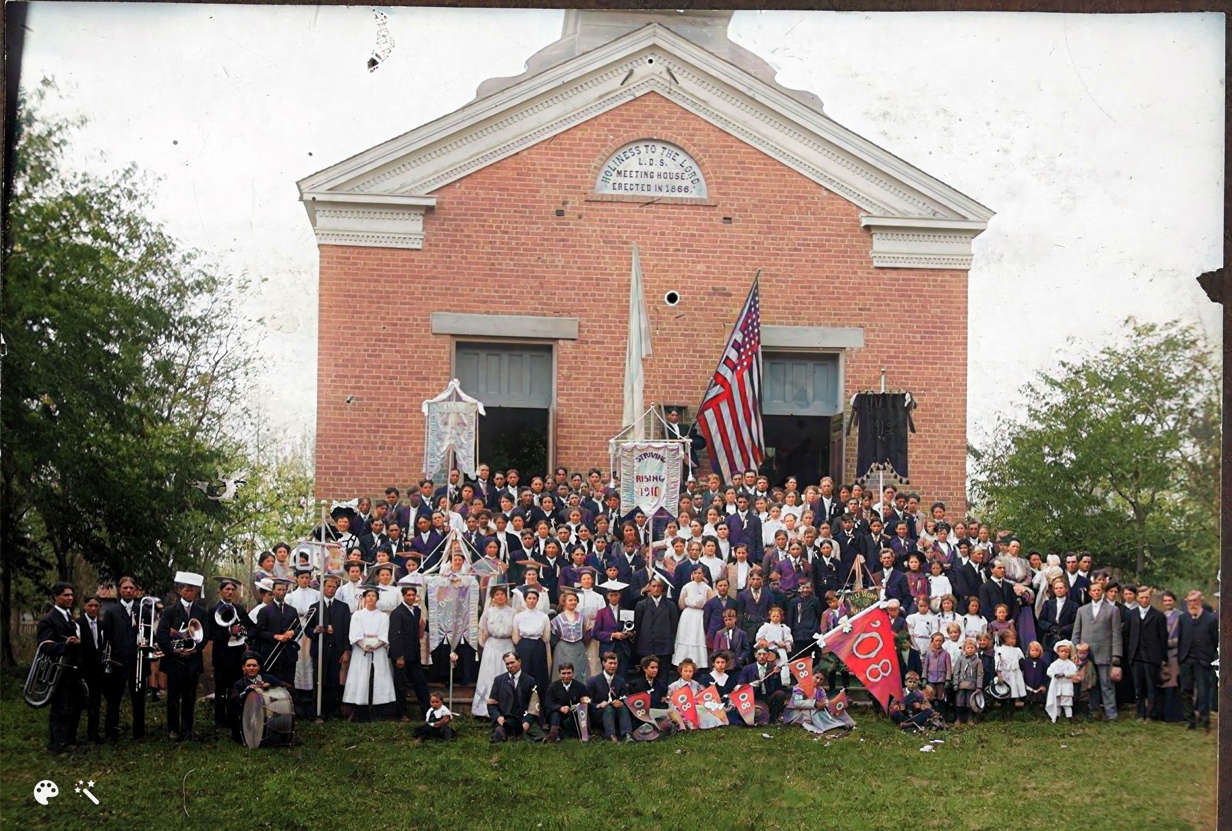
On this site in 1865-66 a tabernacle was erected by the pioneers. Built of local brick, lumber and stone. It was of pioneer architecture with a large assembly hall, gallery, full basement, a tower and large bell. This building was used for church . . . — — Map (db m75614) HM
This monument marks the S.E. corner of fort built by Anson Call and associates in 1855 under direction of President Brigham Young as protection against Indians. The fort was the most northerly outpost in Utah. It was one hundred twenty feet . . . — — Map (db m152317) HM
In commemoration of the outstanding service he rendered the intermountain west as Patriot, Pioneer, Colonizer, Church leader, and Statesman on this plot of ground Aug 19th, 1877 he delivered his last public address when he organized the Box Elder . . . — — Map (db m152538) HM
On East 100 North at North 400 East, on the right when traveling east on East 100 North.
In 1876, Harriet Snow, Box Elder Stake Relief Society President, was asked by the LDS General Relief Society President, Emmeline B. Wells, to join with women's groups throughout the LDS Church to gather and store wheat against a time of need from . . . — — Map (db m240493) HM
Lorenzo Snow was born 3 April, 1814, in Mantua, Ohio, a son of Oliver and
Rosetta Snow. He joined the Church of Jesus Christ of Latter Day Saints in June of 1836 at the age of 22. He crossed the plains, captained his wagon company, and arrived . . . — — Map (db m240492) HM
On West 2300 North at North 4000 West, on the left when traveling east on West 2300 North.
1870
This is the oldest extant Protestant Church building in Utah.
It was dedicated by
Chaplin C.C. McCabe and
Reverend G.M. Peirce on
September 20, 1870 — — Map (db m105257) HM
On North 4000 West near South Front Street, on the right when traveling north.
The Presbyterian work in Utah began at Corinne June 11, 1969 under Rev. Melancthon Hughes, sent here by Rev. Sheldon Jackson, missionary and educator. This bell was later given to the first congregation. In the first century, the Presbyterians . . . — — Map (db m105261) HM
On Elm Grove Dr. south of W 2400 S, on the right when traveling north.
Three Mile Creek, later named Perry, originated in 1853 with the arrival in the Three Mile Creek Valley of the William Plummer Tippetts family and Lorenzo and May Perry. They were soon joined by William Walker, Thomas C. Young, Alex Perry, and . . . — — Map (db m240481) HM
Thirty feet east of this spot was built, in the winter of 1865-1866, under the leadership of Benget P. Woolfenstein, the first community center of the Logan Fifth Ward. Consisting of but one room, 16 by 20 feet. It served, nevertheless, as church . . . — — Map (db m154443) HM
On 100 North at 100 East, on the left when traveling east on 100 North.
Seat of the first Non-Mormon congregation in Cache Valley, 1873. Gothic church and vicarage consecrated 1909. Logan’s first public Library and the Common Room Club housed in the vicarage. — — Map (db m44443) HM
On North 100 West (Utah Route 23) at West 100 North, on the right when traveling south on North 100 West.
Originally built around 1865, the 1½ story rock home of James G. Willie is typical of the over 40 stone homes that were built in Mendon prior to 1880. Brigham Young encouraged early settlers to use native rocks for home construction as he felt . . . — — Map (db m44482) HM
On 10 S Main St. at Center St., on the left when traveling south on 10 S Main St..
Symbol of Heritage
Listed on the National Register of Historical Places in recognition of its architectural and historical significance, and to encourage its preservation.
The 1869 completion of the transcontinental railroad ended an era, that . . . — — Map (db m46302) HM
On South 200 East at East 100 South, on the right when traveling north on South 200 East.
Organized and built by the Greek immigrants of Carbon County. Dedication August 15, 1916 by Reverend Mark E. Petrakis. Built in traditional byzantine style. — — Map (db m148008) HM
On East Main Street east of North 100 East, on the right when traveling west.
On this site was located the Carbon Tabernacle, a landmark and center place of worship from 1914 to 1961 for members of the Church of Jesus Christ of Latter-day Saints.
For 47 years the Tabernacle served as the Carbon and North Carbon Stake . . . — — Map (db m148112) HM
On East Main Street at North 200 East, on the right when traveling west on East Main Street.
The settlement of Price began in 1877 when Caleb B. Rhodes and Abraham Powell arrived here. Two years later a number of Later Day Saints and their families strengthened the settlement. A branch of the church was organized in 1881 and in 1882 George . . . — — Map (db m148009) HM
On North Carbon Drive, on the right when traveling north.
Construction on the Notre Dame de Lourdes Catholic Church began in May, 1919. The building was completed and dedicated June 20, 1923. The basement was used for services during the four years of construction. The church was build under the direction . . . — — Map (db m148117) HM
On South Main Street at East Center Street, on the left when traveling south on South Main Street.
One of the oldest L.D.S. chapels. Finest at time of erection. Augustus Farnham architect. Site dedicated Feb. 11, 1857 by Elder Lorenzo Snow. Grain was stored in stone foundation when Johnston's army advanced. The walls are of adobe. Roof timbers . . . — — Map (db m192433) HM
On Orchard Drive at Mill Street, on the right when traveling north on Orchard Drive.
Heber C. Kimball was born on June 14, 1801 to Solomon Farnham Kimball and Anna Spaulding Kimball in Sheldon, Franklin County, Vermont. He married Vilate Murray on November 7, 1822.
Kimball was converted to The Church of Jesus Christ of . . . — — Map (db m127584) HM
On Orchard Drive at Mill Street, on the right when traveling north on Orchard Drive.
This site was surveyed August 1, 1852 and the mill (largest of it's time in Utah) was dedicated May 6, 1853.
Built on rock foundation with solid adobe walls trimmed with red sandstone, this Burr mill operated until 1892, when roller mills . . . — — Map (db m125132) HM
About 1872 the first soil was plowed in this community and in 1876-77 homes were erected. The people attended church services in Kaysville and Farmington prior to 1882 when Pres. Wm. R. Smith of Davis stake organized a branch of the L.D.S. church . . . — — Map (db m123767) HM
On West Main Street (U.S. 40) at N 100 West Street, on the right when traveling west on West Main Street.
Explorers, trappers and traders were here before Brigham Young sent a group, in 1861, to prepare the way for Mormon colonization. But in October 1861 the U.S. Government set apart Uintah Valley for Indian Reservation. In 1905 a portion was opened . . . — — Map (db m44051) HM
On U.S. 40, 0.1 miles east of East 3rd Avenue, on the right when traveling east.
According to one tradition, the Duchesne River was named after Mother Rose Philippine Duchesne.
Mother Duchesne and the Catholic Sisters of the Sacred Heart of Jesus, had started schools in Missouri. The children of many of the early pioneer . . . — — Map (db m72766) HM
On East Main Street east of South 100 East, on the right when traveling east.
In 1908 the townsite of Elmo was laid out. Each summer a bowery was erected east of
this site where social events were held. In 1911 a group of men purchased the Cleveland
schoolhouse, dragged it with teams and logs to the bowery lot. It was . . . — — Map (db m147941) HM
On South 100 East south of East Main Street, on the left when traveling south.
Before 1890 Thomas E. Davis filed on land in this vicinity. Others followed, erected homes, a schoolhouse and meeting place. June 16, 1912, a branch of The Church of Jesus Christ of Latter-day Saints was organized, George H. Oviatt presiding elder. . . . — — Map (db m147940) HM
On North 100 East north of Main Street, on the left when traveling north.
The Emery LDS Church, built 1898-1900, is the oldest remaining religious building in Emery County. The construction technique, a wood frame sheathed with clapboard and lined with adobe bricks, is distinctive and unusual for turn-of-the-century . . . — — Map (db m147830) HM
On North 300 West at West 200 North, on the left when traveling north on North 300 West.
The Presbyterian church entered Utah Territory and expanded rapidly between 1869 and 1883. Around 1911, they erected this building as the Ferron Wasatch Academy, one of forty such institutions in Utah.
These private educational systems led to the . . . — — Map (db m147843) HM
On Main Street at Center Street, on the right when traveling south on Main Street.
January, 1879, Orange Seeley, Presiding Valley Bishop, appointed Elias Cox to preside over the
Latter Day Saints who had settled on Huntington Creek. In October a ward was organized. Logs were
hauled from the canyon and a meeting house erected by: . . . — — Map (db m147922) HM
On West 100 South at South 100 West, on the left when traveling west on West 100 South.
In 1883 the men and boys of this community brought material from the mountains and built a hall on this spot of ground. They formed a company and rented the hall. The L.D.S. Church purchased the building when Jasper N. Robertson was first Bishop. It . . . — — Map (db m147918) HM
On Utah Route 22, on the right when traveling east.
In 1873, Albert Guiser and others located in a fertile meadow which they named Grass Valley. Surveyors camped on a stream, lassoed a young coyote and called the place Coyote Creek. The first L.D.S. settlers were Isaac Riddle and family who took up . . . — — Map (db m137023) HM
On South Center Street, on the right when traveling south.
This structure, the second public building in Escalante, was erected in 1884 of native stone by Mormon pioneers under the direction of Bishop Andrew P. Schow, Edwin Twitchell and Thomas Heaps. The stone mason was Morgan Richards. It was used to . . . — — Map (db m74746) HM
On South Center Street, on the right when traveling south.
Escalante's first church stood on or near this spot. It was a two-story building made of white sandstone. The upper floor was used as the LDS Chapel and for recreational purposes; the lower floor provided classrooms for church organizations and at . . . — — Map (db m74748) HM
On South Main Street, on the left when traveling north.
In 1904 the Hatch L.D.S. Ward building was erected on this lot. A vestibule was added in 1910 and the bell was purchased with donations from ward members. For many years it hung in the tower and rang out for all civic, social and church activities. . . . — — Map (db m74679) HM
On E. Center Street (U.S. 89) at 100 E, on the right when traveling west on E. Center Street.
Panguitch stake of the L.D.S. Church was organized in 1877 with James Henrie as president. In March 1880, plans were made for a stake house with George Dodds, architect, and M.M. Steel, Sr., chairman of the building. The following men were prominent . . . — — Map (db m27040) HM
During the first settlement of Panguitch, between 1864 and 1867, members of The Church of Jesus Christ of Latter-day Saints paid tithes with produce and cattle, which were kept on this lot and disbursed as needed. Barns and corrals were constructed . . . — — Map (db m74680) HM
Near North 200 East south of East 100 North, on the right when traveling south.
One room of this building, formerly the L.D.S. Church, was erected in 1888. Two years later a second room was added. The bishop was Randolph Stewart; building committee: O.W. Warner, who donated the land, Henry Holyoak, and O.D. Allen; supervisors . . . — — Map (db m95092) HM
On North 200 West south of East 100 North, on the right when traveling south.
In April 1855, forty one men under the leadership of Alfred N. Billings were called to establish a mission in the Elk Mountains. They left Salt Lake City May 7, 1855, arrived at Grand River June 11, and selected the site for a settlement. By July . . . — — Map (db m95090) HM
On North 200 East south of East 100 North, on the right when traveling south.
Constructed of adobe in 1889, the Moab L.D.S. Church was built nine years after the establishment of Moab in 1880. Angus Stocks supervised the laying of the foundation and adobes. Within a few years of original construction an addition was made to . . . — — Map (db m95093) HM
On East Center Street, on the right when traveling west.
Constructed from 1905 to 1906 by local craftsmen, Star Hall is architecturally significant as a fine local example of Richardsonian Romanesque architecture and is historically significant for the role it has played in the community over the years as . . . — — Map (db m95120) HM
On East Center Street, 0.1 miles east of North Main Street, on the left when traveling east.
A tabernacle was erected in 1885 on the adjoining corner of Main and Center Streets and was demolished in the spring of 1932. In 1872 Bishop Christopher J. Arthur suggested that this Tabernacle be built to replace the Social Hall.
Mayhew Dalley . . . — — Map (db m59540) HM
On Main Street at 200 North on Main Street. Reported missing.
Father Silvestre Velez de Escalante with Father Dominguez and eight others, first white men to enter the Great Basin, left Santa Fe July 29, 1776 in attempt to reach Monterey. Abandoning attempt, party passed thru Cedar Valley October 12 on return . . . — — Map (db m241635) HM
On North 100 East, 0.1 miles north of East Center Street, on the left when traveling north.
Site of Church of Jesus Christ of Latter-day Saints recreation building known as the Ward Hall. Rushed to completion in the fall of 1897 and deeded to the State of Utah so the Branch Normal School of the University of Utah could be legally . . . — — Map (db m59543) HM
On Main Street at Center Street, on the right when traveling south on Main Street.
Tithing Lot - Pioneer William Robb Jr. built a rock house, consisting of two rooms with a cellar, diagonally across the street from this location. It was later sold to the Church of Jesus Christ of Latter-day Saints and became a Tithing Office . . . — — Map (db m59622) HM
As a young man, Parley P. Pratt left his farming roots to become a traveling preacher, during which time he was converted and baptized into the Mormon Church. As a faithful saint, Pratt went on a number of Church missions, served as a member of the . . . — — Map (db m1424) HM
On South Main Street, 0.1 miles south of Center Street, on the right when traveling south.
This church built of sandstone brought from Parowan Canyon, started in 1863 and completed about 1876, was the religious center of Parowan Valley. The large amusement hall in the basement was used for school and dances. A stage was erected in the . . . — — Map (db m59613) HM
On East Main Street, 0.1 miles east of Center Street, on the left when traveling east.
A convert of 1831
Utah Pioneer 1850
Settled in Springville
Called to the Dixie Mission 1861
Moved to Summit 1872
Children by Catherine Stoker
John Riley - Sarah Ann
Barbara Adlinda - Sylvanus Cyrus
Sylvester Silas - Cathryn . . . — — Map (db m59572) HM
On West Main Street at West Dublin Avenue, on the right when traveling east on West Main Street.
This building, designed by architect Richard C. Watkins, served as the Eureka L.D.S. Ward Meetinghouse from its construction in 1902 until 1976. It was dedicated in 1903 by Apostle Reed Smoot. The Gothic Revival Style building has been an important . . . — — Map (db m75369) HM
On West Main Street, on the right when traveling east.
Constructed in 1891 with funds secured from the local Methodists and the Mission Conference of 1890, this building is important in documenting the religious life of Eureka and Tintic. Methodism began in Tintic when Dr. Thomas C. Iliff visited and . . . — — Map (db m75370) HM
On North Church Street, on the left when traveling north.
St. Patrick's Catholic Church, built in 1885, remains as one of the oldest Catholic Churches in Utah. Constructed under the direction of Reverend Denis Keily, the building represents both importance of Irish settlement in Tintic, as well as the . . . — — Map (db m75432) HM
On North Main Street, 0.1 miles north of Center Street, on the left when traveling north.
Four early Church pioneers, sons of Jesse Woods and Amelia Shanks Berry, were the founders of Berryville, now Glendale, Utah. Joseph S. and Robert M. and his wife Isabelle Hale Berry, were killed by Indians April 2, 1856. They are burried in . . . — — Map (db m74646) HM
On June 14, 1870 Levi Stewart, who had been called from Salt Lake County by President Brigham Young to head a group of pioneers in settling this area, brought a party with seven wagons from Pipe Springs, where they had camped temporarily, to Fort . . . — — Map (db m41252) HM
From 1877 to 1927, members of the Church of Jesus Christ of Latter-day Saints traveled this route to be united in eternal marriage in the St. George Utah Temple. Thus, the route was named the “Honeymoon Trail.”
Families came from . . . — — Map (db m95008) HM
The great Mormon frontiersman and Indian missionary settled in Tooele Valley, Utah in 1850 and began peaceful negotiations with the Red Men. He was so successful that the officials of the Church of Jesus Christ of Latter-Day Saints sent him to . . . — — Map (db m41254) HM
On West Center Street at North Main Street, on the right when traveling west on West Center Street.
Although religious meetings were held in Kanab from its settlement in 1870, the town lacked a building with the dignity and atmosphere of a chapel. The people met in the Kanab Fort, various homes, in a bowery, and in the Ward Hall for their church . . . — — Map (db m94943) HM
On West Center Street, on the right when traveling west.
The Ward Hall stood on the southwest corner of the Public Square. It was constructed in 1891 as a town hall to accommodate religious services, community meetings, school classes, recreation and amusement. The floor of the hall was elevated and . . . — — Map (db m94941) HM
On State Street (U.S. 89) at the road to Mount Carmel Cemetery, on the left when traveling north on State Street.
In memory of Isaac Behunin,
Mormon Pioneer, Early Utah Settler and
Credited with the naming of Zion Canyon
Early Mormon Pioneer
Isaac Behunin was born October 20, 1803 in Richland, New York to Albert and Nancy Lord Bohanan (Bohannon). . . . — — Map (db m40465) HM
On State Street (U.S. 89) at Muddy Creek Road, on the left when traveling north on State Street.
Settlement of Long Valley and Mt. Carmel
The first written account of the exploration of Long Valley was given by John D. Lee in 1852. Coming from Parowan, the explorers were under the direction of Bishop John R. Smith. James Lewis kept the . . . — — Map (db m40584) HM
On East State Street at S 100 E Street, on the right when traveling east on East State Street.
On December 17, 1901, the first church in Orderville was dedicated by Apostle A. O. Woodruff of the Church of Jesus Christ of Latter-day Saints. This bell hung in the tower and was used each Sunday to call people to church. It was also used to warn . . . — — Map (db m74643) HM
In 1865 Peter Shirts made the first settlement in this area. Other pioneers followed but were forced to vacate because of Indian raids. The town was resettled upstream in 1870; church and school buildings were erected under the direction of William . . . — — Map (db m40379) HM
On Utah Route 257, on the left when traveling south.
The Relief Society in Deseret was first organized in September of 1877. This group of women met in each other's homes until 1878, when they had a large, one-room adobe hall built. In 1894 the members of the Relief Society decided they should . . . — — Map (db m69541) HM
Father Escalante camped here October 2, 1776. His exploring party of ten men headed by Father Francisco Dominguez and map-maker Pacheco preached to the Indians and charted a northern route between Santa Fe, New Mexico and Monterey, California. They . . . — — Map (db m1439) HM
Near East 500 North, 0.2 miles east of Main Street.
These stones, quarried in Chalk Creek and hauled by oxen in 1854, were used in the foundation of the two-storied 30 x 40 adobe church building located in the Pioneer Fort one half block east of Main Street. Remodeled into one 30 x 60 hall with oval . . . — — Map (db m69580) HM
On 100 North, 0.1 miles east of 100 East, on the right when traveling east.
Bell was originally mounted in the steeple of Holden Ward Chapel dedicated in 1883. The bell was rung 30 minutes before Church services were to begin, also rung on special occasions.
Present bell tower erected as a reminder to present and future . . . — — Map (db m69577) HM
On South State Street (Utah Route 66) at South Morgan Valley Road, on the right when traveling south on South State Street.
Porterville was settled by the members of the Porter Family. Sanford Porter Jr., while on duty as a scout in the winter of 1857-58, rode into a canyon so rocky and difficult to travel that he named it Hardscrabble. Here he found a stream of water . . . — — Map (db m48980) HM
On Center Street at W 100 S Street, on the right when traveling south on Center Street.
Kingston Ward of the Church of Jesus Christ of Latter-Day Saints
This site marks the place where the 26 X 48 foot, brick church was erected in 1896 at a cost of $1500. In 1953 it was remodeled and rededicated. The church was used until . . . — — Map (db m240506) HM
On South Main Street (Utah Route 16) north of West Park Street, on the left when traveling north.
On the 14th of March, 1870, the first settlers came into this valley, responding to a call from the General Authorities of the Church of Jesus Christ of Latter Day Saints. Coming from St. Charles, Idaho, were: Randolph H. Stewart, Robert and Charles . . . — — Map (db m149639) HM
On South Main Street (Utah Route 16) north of West Park Street, on the left when traveling north.
Randolph lies in the shadow of the Crawford Mountains against the western foothills of the Upper Bear River between two creeks, Big Creek on the south and Little Creek on the north. In answer to a call from the general authorities of The Church of . . . — — Map (db m149640) HM
On South Main Street (Utah Route 16) north of West Park Street, on the left when traveling north.
Born in Connecticut, Wilford Woodruff was a son of Aphek and Beulah (Thompson) Woodruff; he learned the miller's trade and farming from his father. Wilford was a life-long student of scripture. As a teenager he began reading histories and keeping a . . . — — Map (db m149638) HM
On 14400 South west of 2200 West, on the right when traveling west.
A short time after the pioneers arrived in the Salt Lake Valley in 1847, many began settling other areas of the Territory of Deseret. In 1858 Orrin Porter Rockwell bought sixteen acres of land near Crystal Hot Springs, south of Salt Lake City, which . . . — — Map (db m223829) HM
The Wardle farm began as an 80-acre parcel which was originally worked by Isaac John Wardle Jr., who leased the property from W. Henry Wallace of Salt Lake City.
Johnny Wardle began farming the property in the early 1900s growing alfalfa and . . . — — Map (db m231214) HM
Near Nordic Trail Lane east of South Brighton Loop Road, on the left when traveling north.
Headed by Brigham Young, the company reaching here July 23d numbered 2,587 persons, with 464 carriages & wagons, 1,028 horses & mules, and 332 oxen & cows.
A program of addresses, six brass bands, singing, athletic events, drills by six . . . — — Map (db m153210) HM
On Hillcrest Street at 400 East, on the right when traveling east on Hillcrest Street.
The one-and-a-half story Copperton Community Methodist Church building was constructed in 1942. It was originally sited at the Kearns Army Base, located approximately three miles northeast of Copperton, and was moved to its current location in 1948. . . . — — Map (db m35814) HM
Near Big Cottonwood Canyon Road, on the right when traveling east.
On July 1, 1877, the Granite Ward of The Church of Jesus Christ of Latter-day Saints was created. The residents of both the Granite and Butlerville communities were included. Since most of the people were settling near the mouth of the two canyons, . . . — — Map (db m123706) HM
Near Big Cottonwood Canyon Road, on the right when traveling east.
Mormon pioneers followed their church's teachings of donating one-tenth of their annual increase to the Church. Because cash was scarce, people most often paid their tithing with goods they had grown or produced. The contributions were collected and . . . — — Map (db m123708) HM
In 1915, the first marker to
commemorate the arrival
of the Mormon pioneers
to the Salt Lake Valley
was a large, wooden cross.
The wooden cross was
replaced in 1921 with
the obelisk monument you
see in front of you.
This spot is . . . — — Map (db m171245) HM
The first marker to commemorate the arrival of the Mormon
pioneers into the Salt Lake Valley was a wooden cross. The
eight foot post carried the name “Brigham Young.” The
crosspiece said "This is the place.” In 1921, the wooden . . . — — Map (db m171337) HM
The Old White Meetinghouse
In 1852, on the north wall of Draper Fort, a one-room adobe school building was erected to serve as a gathering place for the early settlement.
In 1860 a second public structure was built. This second structure . . . — — Map (db m231211) HM
On East 12600 South east of 900 East, on the right when traveling east.
John and Elisabeth Enniss joined the Church of Jesus Christ of Latter-day Saints along with hundreds of other members of the United Brethren in Herefordshire, England in the early 1840s. Their conversion sparked a natural desire to emigrate to Utah. . . . — — Map (db m231212) HM
On East 12600 South east of 900 East, on the right when traveling east.
The north wall of the "Old Meeting House" stood near this monument. Here (1861-1869) Dr. John R. Park began his career as an educator in Utah. This school produced many of the state’s leaders and left an indelible love for education in Draper. . . . — — Map (db m224607) HM
Perry Fitzgerald, pioneer, farmer, and rancher was born December 22, 1815 in Redstone, Fayette County, Pennsylvania. Perry moved to Vermillion, Illinois wen he was about 20 years old and began farming. While there, he married and began his family. . . . — — Map (db m224750) HM
(left side:)
Peter was born May 12, 1854 in Odense, Denmark. He converted to the Church of Jesus Christ of Latter-Day Saints at the age of seventeen and served as a missionary in Denmark for two years. He sailed to America in 1865 on the . . . — — Map (db m224768) HM
On South Fort Street south of Pioneer Road, on the left when traveling south.
Peter A. Nielsen, a stone mason and Mormon pioneer from Denmark, built the original portion of the home in 1880 using a granite stone foundation and two courses of soft-fired brick for the exterior walls. Circa 1900 the front portion of the home was . . . — — Map (db m224601) HM
Missionary, pioneer, church leader, farmer, shoemaker, merchant
After whom the city of Draper, Utah is named
Born- April 24, 1807
Midland District, Upper Canada
Baptized into LDS Church March 20, 1833
Migrated to Utah . . . — — Map (db m224770) HM
On Pioneer Road (6000 West), 0.1 miles north of Main Street (W 13100 S), on the left when traveling south.
Herriman was settled in 1851 by the families of Henry Herriman, Thomas Butterfield, and John Stocking. In 1853, Brigham Young called twenty families to strengthen the settlement. Henry Herriman was chosen the first presiding Elder of the L.D.S . . . — — Map (db m35031) HM
On 13100 South (Main Street) at 5800 West, on the right when traveling west on 13100 South (Main Street).
Born: June 17, 1811 - Died: April 6, 1890
Thomas Butterfield, his wife Mary Jane Parker and little Mary Jane left their home in Farmington, Maine in 1869 to travel to Kirtland, Ohio to meet the Prophet Joseph Smith. There they became lifelong . . . — — Map (db m34506) HM
On 2700 South at Titanium Drive (8650 W) when traveling east on 2700 South.
Settlers came to this part of the valley around 1850 to farm and stock range. It was known as Pleasant Green and was part of the Brighton Ward of the Salt Lake Stake.
Traveling so far to meetings presented a problem, so members met in private . . . — — Map (db m35086) HM
On 8400 West (State Highway 111) at 4100 South, on the left when traveling south on 8400 West.
In 1876 President Brigham Young called the women of the Relief Society to gather and store wheat to be used in times of need. Pleasant Green Relief Society was organized in 1879, Charlotte Hirst, President. June 24, 1885, a rock granary built on . . . — — Map (db m35076) HM
Near Union Park Avenue, on the right when traveling south.
Early in 1849 the Pioneers of Union settled 1½ miles South-East of here, water, grass, wood and clay were abundant, Silas Richards first Bishop and school teacher arrived November 4, 1949. In 1853-54 Union Fort was built on ten acres donated by . . . — — Map (db m150037) HM
The first known residents of the Riverton area were the Yo No Indians, a poor tribe living along the Jordan River. Well-worn trails extended from Utah Lake where various tribes wintered, to Bear Lake where they rendezvoused during the summer. Much . . . — — Map (db m34682) HM
Near South 1500 West, on the right when traveling north.
In 1886, the Riverton Branch of the Church of Jesus Christ of Latter-day Saints purchased choice land for a tithing yard from Samuel L. Howard Sr., located between 12400 and 12600 South, one mile northeast of this park. Members brought one tenth of . . . — — Map (db m34681) HM
On Big Mountain Pass (Utah Route 65), on the right when traveling east.
On 19 July 1847, scouts Orson Pratt and John Brown climbed the mountain and became the first Latter-day Saints to see the Salt Lake Valley. Due to illness, the pioneer camp had divided into three small companies. On 23 July, the last party, led by . . . — — Map (db m150080) HM
This monument was erected July 23, 1933, and marks the last camp site of the first company of Mormon Pioneers, under the leadership of President Brigham Young, before entering the Salt Lake Valley, July 24, 1847. — — Map (db m41379) HM
On Evergreen Avenue (3425 South), on the right when traveling east.
In 1824-26 the first black man came into Utah Territory. He was a trapper for the Rocky Mountain Fur Company. His name was James Beckworth. In succeeding years many black people would follow to contribute to the development of Utah, socially and . . . — — Map (db m1379) HM
Near Ensign Vista Drive west of East Greenstroke Drive.
From the arrival here of Brigham Young, Mormon pioneers regarded this peak as a symbol of the latter-day gathering of Israel. In August 1847 they raised an American flag upon it to demonstrate support for the mandate given through Isaiah to "lift ye . . . — — Map (db m234455) HM
Near Ensign Vista Drive west of East Greenstroke Drive.
President Gordon B. Hinckley has spoken of the mission of The Church of Jesus Christ of Latter-day Saints and its members, which is symbolized by Ensign Peak:
"This great pioneering movement of more than a century ago goes forward with . . . — — Map (db m234452) HM
On North Main Street at 200 N, on the right when traveling north on North Main Street.
The mansion, completed in 1901, was designed for Alfred W. and Elizabeth McCune by architect S. C. Dallas. Alfred McCune acquired great wealth through railroad, mining, and timber enterprises. In 1920, after the McCune's moved to Los Angeles, they . . . — — Map (db m132485) HM
Near Ensign Vista Drive west of East Greenstroke Drive.
"And he shall set up an ensign for the nations, and shall assemble the outcasts of Israel, and gather together the dispersed of Judah from the four corners of the earth….Lift ye up a banner upon the high mountain" (Isaiah 11:12; 13:2).
Long . . . — — Map (db m234451) HM
Near West South Temple Street at North West Temple Street.
The Assembly Hall, constructed of granite
stone left over from the building of the
temple, was completed in 1880. It is a
place of public worship, in which visitors
are welcome. Although the building is used
mainly for conferences of Latter-day . . . — — Map (db m172067) HM
The Church of Jesus Christ of Latter-day Saints constructed this building between 1914 and 1917 to serve as its headquarters. Prior to its completion, the office of the Church President was located just to the east between Brigham Young’s Lion . . . — — Map (db m35685) HM
259 entries matched your criteria. The first 100 are listed above. Next 100 ⊳