On Clermontville-Laurel Road, 0.1 miles east of Ohio River Scenic Parkway (U.S. 52).
The first place of higher learning in Clermont County. A woman’s dream, a man’s covenant with God.
Built in the valley below by Rev. Daniel Parker’s family. Graduated 1500 students of many professions.
First Principal—James, their son, . . . — — Map (db m204649) HM
On Clermontville Laurel Road (County Route 31), on the left when traveling north.
Mt. Zion Chapel The Mount Zion Chapel of the Christian Church was built in 1872 on this hill adjacent to the members' cemetery outside of Clermontville. The site was part of a two-acre parcel that had been secured from the farm of William R. . . . — — Map (db m99887) HM
Near Locust Street north of West Main Street (Ohio Route 50).
One of the oldest fairs in Ohio. The first fair
was held in Franklin, Monroe Township, in 1846.
The fair was held in Bantam, 1849 - 1856. and
Olive Branch, 1857 - 1863. The fair relocated to
Boston; now called Owensville. The Clermont
County . . . — — Map (db m202990) HM
On Shawnee Trace Road (County Route 263), on the right when traveling east.
Side A Descendants of Lemuel Garrison Sr., a Revolutionary War soldier, were among the first Europeans to own and settle land at Garrison Corner (intersection of State Route 123 and Shawnee Trace) . Garrison Cemetery burials took place from . . . — — Map (db m121044) HM WM
After World War II, colleges across the country struggled to house students following surges in enrollments made possible by the G.I. Bill. Wilmington College was no exception. The College's enrollment doubled compared to pre-war levels. On April . . . — — Map (db m121047) HM WM
On Birdsall Street, on the left when traveling east.
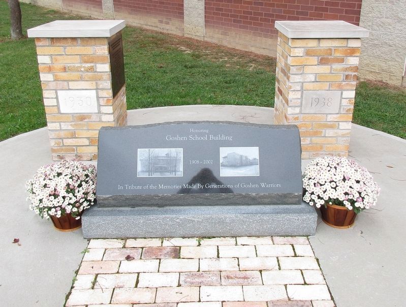
Smith Place School was built on this site in 1893 as a high school. It was an outstanding example of Romanesque architecture and the arched stone entrances were quarried locally from Todd's Fork. Many generations attended classes here and it became . . . — — Map (db m18730) HM
The 19th century saw a great migration of Quakers from the Carolinas and from eastern Ohio to southwestern Ohio. Attracted by rich soil and abundance of fresh water and springs, Quakers became the dominant religious group in the region. Clinton . . . — — Map (db m27837) HM
On Sprucevale Road (County Route 428) north of Spruce Court, on the left when traveling north.
Dustin Marshall Huffman lived his life with a “Pay It Forward” attitude, always there to help out, even if it was for a stranger. He was pure goodness with a touch of orneriness and a smile that could light up a room.
On June 30th 2009, Dustin . . . — — Map (db m55113) HM
On East 4th Street, 0 miles west of Broadway Street, on the right when traveling west.
At the beginning of the Twentieth Century, Andrew Carnegie, who spent time with relatives in East Liverpool during his childhood, donated $50,000 toward the construction of a public library. The building was dedicated on May 8, 1902.
In the 1990's . . . — — Map (db m44150) HM
On East 4th Street at Broadway Street, on the right when traveling east on East 4th Street.
Site of schools since 1820's Log House School. Union School in 1869.
Central School built in 1894 for $65,000.00 and held 1,000 students.
In 1971 following 77 years of service as East Liverpool's High School it was demolished.
The ELHS Alumni . . . — — Map (db m80712) HM
On 4th Street, 0 miles east of Washington Street when traveling west.
This building was built in 1924 by local industrialist Monroe Patterson as a memorial to his late wife, Mary T. Patterson. The structure was a home for working women and served as such for many years. When the building closed, it was donated to Kent . . . — — Map (db m44166) HM
On Harvey Avenue (Ohio Route 39) 0.4 miles east of Bushwick Street, on the right when traveling east.
Land Ordinance of 1785. In April 1784, the Continental Congress adopted the Report of Government for the Western Territory, a broad plan drafted primarily by Thomas Jefferson for organizing the United States' new western lands that were ceded . . . — — Map (db m221421) HM
On Maple Street, on the right when traveling east.
George Washington Crile was born in 1864 at Chili, in Crawford Township, Coshocton County. Before embarking on his notable medical career, he graduated from Northwestern Ohio Normal School (now Ohio Northern University) at Ada, teaching for two . . . — — Map (db m15178) HM
On Whitewoman Street, on the right when traveling north.
This building, dedicated in the spring of 1987, was named in honor of Raymond Hay as a lasting memorial to the late Coshocton businessman for the many contributions he made to the Roscoe Village restoration and to Coschocton County. It is also . . . — — Map (db m26403) HM
On Whitewoman Street, on the left when traveling north.
James Taylor, owner of a Coshocton woolen mill, built a house and possibly the fruit cellar on this lot in 1826. Taylor moved to California in 1840. Subsequent owners include David Frew, a miller, farmer, and a postmaster, and Daniel Rose, a . . . — — Map (db m27383) HM
On Front Street (Ohio Route 237) 0.2 miles north of Bagley Road (Ohio Route 237).
In 1845, Baldwin Institute, one of the first schools in the area open to all students regardless of gender, race, or creed, was chartered. The wealth generated by the sandstone and grindstone industries of Berea allowed John Baldwin to found the . . . — — Map (db m3536) HM
On East Bagley Road, 0.2 miles east of Eastland Road.
A find example of the district school building common to Ohio int he early years of the twentieth century. This two-room, red-brick schoolhouse was completed in 1913. Accommodating elementary school children in east Berea and adjacent areas of . . . — — Map (db m3532) HM
For more than ninety years, this area was the heart and soul of Berea's sandstone quarries. In the early 1830s, John Baldwin discovered that the area's sandstone deposits made superb grindstones and building stones. in the 1840s, thriving sandstone . . . — — Map (db m5516) HM
On Seminary Street, 0.2 miles north of Church Street.
On this site the Lyceum Village and the Berea Seminary were established in 1837 by John Baldwin, Jame Giruth, Henry O. Sheldon, and Josiah Holbrook. Their vision was to create the first in a connected series of Lyceum Villages. The Villages were . . . — — Map (db m3538) HM
On Broadview Road (Ohio Route 176) at Boston Road, on the right when traveling north on Broadview Road.
In 1811, Colonel John Breck sent Seth Paine to survey a new
township of the Western Reserve. Travelling from Massachusetts,
the Paine family journeyed by wagon pulled by a team of oxen,
a trip that took them forty-two days. For his . . . — — Map (db m137187) HM
On Detroit Avenue (Alternate U.S. 6) west of West 54th Street, on the right when traveling west.
In 1907, the Templin-Bradley Company’s Children’s Flower Mission was developed in response to the Cleveland Public Schools Horticulture Program, supplying seed packets for 1 cent each — commonly referred to as Penny Packet Seeds. This . . . — — Map (db m136909) HM
On Kinsman Road (U.S. 422) at East 146th Street, on the right when traveling east on Kinsman Road.
Andrew J. Rickoff,
Educator, Administrator, Innovator.
The Cleveland Public School Board recognized one of its first superintendents by naming one of its elementary schools in his honor. Andrew Jackson Rickoff (1824-1899) was born in New . . . — — Map (db m137061) HM
On Lorain AVenue (Ohio Route 10) at West 30th Street, on the left when traveling east on Lorain AVenue.
In 1886, Bishop Richard Gilmour (1824-1891) of the Roman Catholic
diocese of Cleveland requested that the Jesuit superior of Buffalo
establish a high school on Cleveland’s west side. The Jesuits, an
order of the Roman Catholic Church founded by . . . — — Map (db m229238) HM
On Martin Luther King Junior Drive south of Saint Casimir Way, on the right when traveling south.
In 1962, Asian Indian students of Case Western Reserve University started India Association of Cleveland (IAC). In 1967, IAC started a newspaper "LOTUS," regarded as the first such Asian Indian community newspapers in the United States. In 1978, IAC . . . — — Map (db m6946) HM
Elected third national president of Alpha Kappa Alpha Sorority, Inc. First Greek letter sorority for African-American Women.
Initiated into Zeta Chapter at Wilberforce University.
Held membership for more than 50 years in Alpha Kappa Alpha. . . . — — Map (db m11931) HM
On Wade Oval near Jeptha Drive, on the right when traveling east.
Named for the streetcar turnaround once located at Euclid Avenue and East 107th Street, University Circle is a 600-acre district that is home to many of Cleveland's major cultural, educational, medical, and service institutions. The area was first . . . — — Map (db m18158) HM
Briton, industrialist and philanthropist who came to Cleveland in 1848. Formed the Cleveland Provision Company in 1875, Cleveland's largest meat packer. Pioneered meat shipping using refrigerated cars. Built the Rose Building, E. 9th and Prospect, . . . — — Map (db m12116) HM
On Bunts Road south of Detoit Avenue (Alternate U.S. 6), on the right when traveling south.
Dr. Jared Potter Kirtland was a prominent nineteenth century professor, physician, naturalist, and horticulturalist. In 1837, Kirtland purchased land in Rockport Township that stretched from Madison Avenue to Lake Erie. Kirtland used that land as a . . . — — Map (db m136827) HM
This Little Red Schoolhouse served children from Berea, Brookpark, and Middleburg township. The first mayor and council of Middleburg Heights were elected here. During its colorful history, the schoolhouse has been a City Hall where town meetings . . . — — Map (db m5548) HM
James Abram Garfield, 20th President of the United States, was born here in 1831. His father died when he was two, but the family remained on the farm where James helped when he was not attending school. He continued to live here through his years . . . — — Map (db m118214) HM
On Cedar Point Road east of Lewis Road, on the left when traveling west.
From 1829 to 1842, the northern region of Olmsted Township was called Frostville. It was named by Elias C. Frost, who operated a post office in his farmhouse located at what became the intersection of Kennedy Ridge and Columbia Roads in North . . . — — Map (db m136817) HM
On Lorain Road (Ohio Route 10) at Christman Drive, on the right when traveling west on Lorain Road.
David Stearns, the first permanent settler, built a log cabin near this site on the "Ridge" (Lorain Road) in 1816. Stearns was given this land by his father, Elijah, who had bought 1,002 acres from the Olmsted family. This area of North Olmsted was . . . — — Map (db m43342) HM
On Mastick Road, 0.2 miles west of Clague Road, on the left when traveling west.
Adele Von Ohl Parker was a daredevil stunt rider once starring in Buffalo Bill's shows. Stranded during the Depression, she started a riding school; her flamboyance captivated her young riders. The 34-building ranch was the scene of many rodeos and . . . — — Map (db m11547) HM
On Butternut Ridge Road, on the left when traveling east.
In 1829 the citizens of Lenox voted to change the township name to Olmsted as their part of a bargain to acquire 500 books owned by the heirs of Aaron Olmsted.
Believed to be the first publicly-owned library in the Western Reserve, the books . . . — — Map (db m43344) HM
Crile General Hospital, named for renowned Cleveland surgeon, Dr. George W. Crile, was dedicated at this site on April 21, 1944. Dr. Crile, founder of the Cleveland Clinic Foundation, was a brigadier general in the U.S. Army. The $4.5 million . . . — — Map (db m23924) HM
On Lander Road, 0.3 miles north of the circle at Fairmount and Gates Mills Boulevards, on the left when traveling north.
The first women’s college chartered in the state of Ohio, Ursuline College opened in 1871 in downtown Cleveland as part of the educational mission of the Order of St. Ursula (O.S.U.). Founded in Italy in 1535 with an early presence in North America, . . . — — Map (db m137093) HM
Near Lyman Circle north of Laureldale Road, on the right when traveling north.
Florence E. Allen (1884-1966) was nicknamed “first lady of the law” for her many firsts as a woman in the legal profession. After graduating from Western Reserve College for Women, she taught at Laurel School from 1906 to 1909. She then became a . . . — — Map (db m229695) HM
John Carroll University opened its doors as Saint Ignatius College on
September 6, 1888. Originally located on Cleveland’s West Side, the
College was founded at the request of Bishop Richard Gilmour by
German members of the Society of Jesus (the . . . — — Map (db m190030) HM
On West Canal Road, 0.2 miles north of Old Rockside Road, on the right when traveling north.
One-room schoolhouses, like the red brick building across the street, once dotted the landscape. It was constructed with locally-made bricks in 1903, and was used as a school until 1917. The building was used as a school until 1917. The building . . . — — Map (db m234948) HM
On Hathaway Road, on the left when traveling east.
Valley View Village
Town Hall
erected as an eight grade
school in 1907, A.E. Smith,
Principal. Became Village Hall
in 1941, since used for municipal
purpose. Incorporated 1919,
Burt C. Allen, Mayor
Valley View-Cuyahoga Valley
Historical . . . — — Map (db m140166) HM
On Martin Street (Ohio Route 541) at Washington Avenue (Ohio Route 49/121), on the left when traveling west on Martin Street.
"I would like to see every woman know how to handle firearms as naturally as they know how to handle babies.” Annie took it upon herself to teach women how to shoot for sport and for protection. She estimated teaching 15,000 women throughout her . . . — — Map (db m193052) HM
On Holgate Avenue, on the right when traveling north.
William C. Holgate (1814-1888) settled in Defiance in 1836. A lawyer by profession, Holgate rode on horseback to Columbus, Ohio during the winter of 1844-45 with a petition he had drafted, which resulted in the establishment of Defiance County. . . . — — Map (db m173030) HM
Near Ralston Avenue, on the right when traveling east.
Founded in 1919, Zonta International is a global service organization of executives in business and the professions working together, across political and social boundaries, to advance the status of women worldwide. The Defiance chapter was founded . . . — — Map (db m234348) HM
On W. High Street, on the left when traveling north.
Presented to the community of Hicksville by
Carma Johnson Rowe
1953 A.D.
Built on the site of the home of A.P. Edgerton,
a founding father of this community. — — Map (db m173034) HM
On Dublin Road (Ohio Route 257) at Bellpoint Road, on the right when traveling north on Dublin Road.
Bellpoint Buccaneers
In the early part of the twentieth century, most small villages in Ohio focused community pride on the accomplishments of their high school's athletic teams. The Bellpoint basketball teams of the 1920s were a great example. . . . — — Map (db m12812) HM
Near South Sandusky Street, 0.1 miles north of Park Avenue, on the right when traveling north.
This sculpture recreates the dimensions of the back porch on the original Butler A. Jones House of Black Culture. This was a space of respite, socializing, and community for Black students at OWU. Back Porch is intended to serve as a new performance . . . — — Map (db m203315) HM
On South Henry Street, 0.2 miles north of Wilmer Street, on the right when traveling north.
• Athlete, teacher, coach, lawyer, baseball legend, and humanitarian
• Credited with breaking the color barrier in Major League Baseball by signing Jackie Robinson
• Responsible for the formation of the All-American Women's Baseball League . . . — — Map (db m203330) HM
Near South Sandusky Street just north of Spring Street, on the right when traveling north.
This storm net structure was developed as a student research project in cooperation with Ohio Wesleyan University, the City of Delaware Public Utilities Department, and StormX Water Systems. The purpose of this project is to determine if the . . . — — Map (db m203320) HM
On Sandusky Street, on the right when traveling north.
In Memoriam
This rock and these three flowering crab trees are placed here in loving memory of three Ohio Wesleyan University students, who died in an auto accident while attending a conference on Russian studies at Oberlin College on September . . . — — Map (db m12833) HM
On Sandusky Street at Park Avenue, on the right when traveling north on Sandusky Street.
Edwards Gymnasium
The gym was dedicated February 22, 1906. It is named in memory of OWU Trustee John Edwards whose initial gift made its construction possible. At the time of its completion it was considered the largest and finest basketball . . . — — Map (db m12854) HM
Built in 1833 as a health resort named the Mansion House Hotel, Elliott Hall is noted as Ohio's oldest collegiate Greek Revival building. The closure of the Bank of the United States and an economic panic in 1837 created nation-wide financial . . . — — Map (db m12822) HM
On South Henry Street, 0.2 miles north of Wilmer Street, on the right when traveling north.
• Instrumental in the early development of OWU athletics, particularly football
• Responsible for OWU's involvement in the Buckeye Athletic Conference (conference founder)
• OWU beat Michigan and Syracuse in football in 1928 under his . . . — — Map (db m203344) HM
On West Winter Street at Elizabeth Street, on the right when traveling west on West Winter Street.
George W. Campbell originally built this highly picturesque structure in 1854. Designed with Romanesque and Norman Revival architectural features - a round tower, arched windows and doorways - and constructed of locally mined blue limestone, the . . . — — Map (db m12817) HM
On South Sandusky Street at Spring Street, on the right when traveling north on South Sandusky Street.
Professor of psychology & Ohio Wesleyan's first director of information systems. A fierce proponent of the value of a liberal arts education & rigorous scientific inquiry. A respected friend to OWU, Roy is missed & remembered with love. — — Map (db m203318) HM
On South Henry Street, 0.2 miles north of Wilmer Street, on the right when traveling north.
• Legend in collegiate soccer
• OWU gained national NCAA division III recognition in numerous sports during his tenure
• OWU recorded five national top 25 finishes in Sears Directors' Cup standings during his tenure
• Four NCAA . . . — — Map (db m203367) HM
On South Henry Street, 0.1 miles north of Wilmer Street, on the right when traveling north.
• Nationally renowned as a leader in the development of athletics
• After OWU, served for 35 years as director of athletics at the Ohio State University — — Map (db m203341) HM
On North Franklin Street just north of East William Street (U.S. 36).
In the mid-19th century
Mrs. Joan Hills Murray conducted
a school in this building.
Among her students was
Rutherford B. Hayes. although
generally known as
“Mrs. Murray’s School” this
edifice was originally built
for Sophia Moore in 1821 as . . . — — Map (db m228240) HM
Near South Sandusky Street at Park Avenue, on the right when traveling north.
Ohio Wesleyan University was established in 1842, in one building (Elliot Hall) which at the time was located a short distance from the proposed location for the bioretention cell. Elliot was built near a sulphur spring, which flowed into the . . . — — Map (db m203316) HM
On South Henry Street, 0.2 miles north of Wilmer Street, on the right when traveling north.
• Legend in collegiate golf
• Longest tenure of any coach in any sport in OWU's history (39 years, 1954-93)
• Assistant to the president for athletics (1991-93)
• A founder of the North Coast Athletic Conference
• Instrumental in the . . . — — Map (db m203347) HM
On South Henry Street, 0.2 miles north of Wilmer Street, on the right when traveling north.
• A leader in the Ohio Athletic Conference Administration
• Started and expanded many sports at OWU including soccer, wrestling, and lacrosse
• Started the OWU Athletic Hall of Fame (1961), instrumental in the inclusion of women (1976)
. . . — — Map (db m203346) HM
Near South Henry Street south of East William Street (U.S. 36), on the right when traveling south.
On the morning of May 3, 1890, Ohio Wesleyan University and The Ohio State University met at this location for a football game. It was the first game in Ohio State football history. Ohio Wesleyan had invited the newly organized team to a contest as . . . — — Map (db m18316) HM
Ohio Wesleyan owes its location to the initial efforts to establish a resort for healing purposes on the site of the Sulphur Spring. When the business faltered, Adam Poe, a pastor and several citizens purchased it and gave it to the Methodists for a . . . — — Map (db m18313) HM
Near South Sandusky Street at Spring Street, on the right when traveling north.
This tablet and beech tree
Gifts of Ohio Wesleyan Monnett Clubs, commemorate the work of Rev. Joseph H. Creighton Ohio Conference who in 1872 planted the campus arboretum
Prof. Asa Gray, Harvard, his friend presented many trees now adorning the . . . — — Map (db m224096) HM
University Hall was completed in 1893. It is constructed of Amherst Sandstone. The bell tower rises to a height of 148 feet. The structure houses administrative offices, classrooms, and the legendary Gray Chapel. Among the celebrities who have . . . — — Map (db m12845) HM
On Cheshire Road at Old State Road/Lackey Old State Road, on the right when traveling west on Cheshire Road.
Berlin School stood on this site from 1915 to 1975. The first graduating class was in 1916, with the first graduate being Mildred Schanck. The last graduating class was in 1953 with 14 members. Over these 38 years, 472 students graduated from . . . — — Map (db m20554) HM
On State Route 521, on the left when traveling east.
This acorn was on the top of the arch at the front entrance to Brown School. The school was built in 1915. The acorn and the brick columns in front were original to the school. — — Map (db m236805) HM
On State Route 521, on the left when traveling east.
Former Site of Brown Township School
1915 - 2010
1915 School Board A. Humes • J. Wornstaff • H. Cowgill • C. Sheets • F. Plunkett • Wes Ott, Clerk Presented To Brown Township Loyalty Song We're loyal to you Brown Hi
For we . . . — — Map (db m236803) HM
Near Ohio Route 257 north of Glick Road, on the left when traveling north.
The partnership between Dr. Lisa Dabek's Tree Kangaroo Conservation Project and local landowners in Papua, New Guinea provides a model of wildlife protection for the endangered Matschie's tree kangaroo. Since 1996, TKCP and local PNG people have . . . — — Map (db m200903) HM
On Ohio Route 203 south of John Street, on the left when traveling north.
Built in 1917, the Radnor School building was designed by local architect William R Powell. He supervised construction under the direction of school board members W.P. Penry (President), Rees Jones, Wm Jones, Walter Baxter and J.T. Lodwig. The . . . — — Map (db m203285) HM
On Africa Road, 0.2 miles south of Polaris Parkway, on the right when traveling north.
The Sharp family homes and their locations on N. State Street and Africa Road mark an important route through Westerville on the Underground Railroad. The family patriarch, Garrit Sharp, was an original settler of Sharp's Settlement, now . . . — — Map (db m171804) HM
On Edison Highway (Ohio Route 113) east of Savannah Vermilion Rd (Ohio Route 60), on the left when traveling east.
Birminghan School was built in 1916 and served as a high school until school districts merged in 1954, and it was repurposed into an elementary school. In 1988, schools districts merged again and the Birmingham School was closed.
The Firelands . . . — — Map (db m144388) HM
On Ohio Street south of Cleveland Road West, on the right when traveling south.
Ohio’s oldest continuing summer theatre, the Huron Playhouse,
has been housed at McCormick Middle School for its entire
history. Dr. Frederick G. Walsh (1915-1999) of the Bowling
Green State University (BGSU) Speech Department founded
the . . . — — Map (db m224978) HM
On West Adams Street east of Jackson Street, on the right when traveling east.
Erie County Jail. The Erie County Jail was built in 1882-1883 in the Gothic style. Constructed of blue limestone, the $45,750 facility featured 26 cells, the sheriff’s residence, and boasted then modern innovations including chrome steel bars . . . — — Map (db m141925) HM
On Columbus Avenue south of East Jefferson Street, on the left when traveling south.
Legendary University of Notre Dame Head Football Coach
Knute Rockne married Bonnie Skiles of Kenton, Ohio in the
rectory of Saints Peter and Paul Catholic Church on July 15,
1914. Father William F. Murphy officiated.
The two met in the summer of . . . — — Map (db m141931) HM
On BIS Road, 4.5 miles south of S Broad Street / Hamburg Road (County Route 55), on the left when traveling south.
As the nation’s first and largest minimum
security correctional facility, the Fairfield
School for Boys served over 100,000 Ohio
juvenile offenders. The school was converted
to an adult facility in 1980.
(text on supplementary . . . — — Map (db m119566) HM
On Elmwood Drive near West Fair Avenue, on the right when traveling north.
was placed on the
National Register of Historic Places
by the National Park Service,
U.S. Dept. of the Interior,
Sept. 10, 1987 in recognition of its
historical and architectural significance.
Originated at Logan 1872;
moved to . . . — — Map (db m52871) HM
This building, the original Liberty Twp. No. 6 School, was presented to the Fairfield County Agriculture Society by the Arthur Weakley Family of Baltimore, Ohio, August, 1976. The original school house bell was presented by Douglas A. Weakley of . . . — — Map (db m61844) HM
On Arbor Valley Drive, on the left when traveling north.
The design for the fifty star flag was born here at Lancaster High School in 1958 when student Robert Heft designed it for a history class project. Reasoning that since Alaska was seeking admission as a state and that Hawaii would soon follow, Heft . . . — — Map (db m183072) HM
On Columbus Street (Ohio Route 256) at Center Street / Lockville Road, on the right when traveling east on Columbus Street.
This Carnegie Library was built in 1916 with funds from the Carnegie Corporation. It was constructed and furnished from a Carnegie Corporation grant of $10,000. Pickerington was one of the smallest of the 1,946 communities in the . . . — — Map (db m17432) HM
On Baltimore-Somerset Road (Ohio Route 256) 0.1 miles west of the railroad tracks, on the left when traveling west.
Back in the late 1800's and early 1900's, Thurston was the railroad town which everybody knew. The town was the only place in southeast Ohio which a train could turn around 360 degrees and choose which track it would want to go on. Thurston had a . . . — — Map (db m24813) HM
On Pleasant Ridge Avenue at Main Street (U.S. 40), on the left when traveling north on Pleasant Ridge Avenue.
Founded in 1830 as a Lutheran Seminary and chartered as a University in 1850, Capital University offers diverse undergraduate and graduate programs in the arts, sciences and professional studies.
Ethical, moral and religious values essential to . . . — — Map (db m15784) HM
On Washington Street just north of Franklin Street, on the left when traveling north.
Over its 145 years, the Old Canal Winchester School building played a significant role in the community. The original four-room building opened in 1862 and its first high school class graduated seven in 1886. Canal Winchester's growth is . . . — — Map (db m223471) HM
On West Oak Street near North High Street, on the right when traveling west.
This building was generously donated to the
Village of Canal Winchester
in the interest of historic preservation by the following businessmen: Lloyd Stebelton, Dick Weiser, Don Weiser, Robert Wood, Neil Wyman.
It was moved from its previous . . . — — Map (db m12180) HM
On High Street, 0.1 miles south of Waterloo Street, on the right when traveling south.
In Honor of
Dr. Bland L. Stradley
1889-1957
Dr. Stradley was a noted educator whose career began in 1913 as principal of the Canal Winchester High School. He spent 38 consecutive years at the Ohio State University where he was Vice President in . . . — — Map (db m12532) HM
On High Street (U.S. 23) at Stimmel Street, on the right when traveling south on High Street.
The German Seminary of the Evangelical Lutheran Synod of Ohio, the first Lutheran theological seminary west of the Appalachian Mountains, began instruction under Pastor Wilhelm Schmidt in Canton in 1830. The seminary relocated to Columbus at this . . . — — Map (db m80014) HM
On East North Broadway, on the right when traveling east.
Clinton Township High School
The first school in Clinton Township was opened in 1809. That
school was located on the west side of the Olentangy River and
children had to wade across to attend. The 1872 map of the
township shows a school . . . — — Map (db m108022) HM
689 entries matched your criteria. Entries 101 through 200 are listed above. ⊲ Previous 100 — Next 100 ⊳