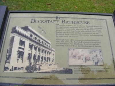
From its opening the handsome Buckstaff Bathhouse aggressively promoted its image. To gain customers the owners mounted a huge sign on the roof to attract people from the large hotels a block away. Other bathhouses lost character as they modernized, . . . — — Map (db m61793) HM
Gambling flourished in Hot
Springs for decades prior to 1967.
During this time, one of the most
popular establishments for
gambling activity was the
Southern Club, formerly located
at 250 Central Avenue. — — Map (db m211121) HM
Hot Springs experienced a
building boom during the 1870s
and 1880s. By the time of the
formation of Garland County in
1873, the town had 24 commercial
hotels and boarding houses with
a capacity of 1,500 to 2,000
visitors per day. — — Map (db m211140) HM
Asa Thompson's bathhouse, built
in 1830, is credited with being
the spa's first public bathhouse.
At that time, almost all visitors
came in the summer. The open
baths, open log cabins and
sweathouses made warm weather
the only practical time . . . — — Map (db m211094) HM
Hot Springs' population reached
201 by 1860. At this time, there
were two hotels and a number
of smaller boarding houses that
took care of visitors. There were
seven bathhouses and some
smaller pavilions on the east
side of Hot Springs Creek. — — Map (db m211087) HM
The arrival of Josiah and
Nancy Mellard in 1820 marked
the beginning of the development
of the village of Hot Springs
into a resort. They built a
double log cabin and operated
their quarters as a hotel. — — Map (db m211117) HM
The present masonry Lamar Bathhouse, completed in 1923, has a symmetrical, California style of architecture. The large lobby contains nostalgic murals of historic landscapes, and country scenes.
Art Deco stairs, signs, and lights decorated the . . . — — Map (db m61777) HM
The first Lamar opened in 1888, the final year that Georgia-born Lucius Quintus Cincinnatus Lamar (1825-1891) — a former Confederate officer, overseas ambassador for the Confederacy, and U.S. Representative and Senator for Mississippi — served as . . . — — Map (db m211200) HM
The mission style of the Ozark Bathhouse may relate to the claim that Spanish explorer Hernando de Soto visited the hot springs. The building’s twin towers are strictly decorative. On Bathhouse Row, the Quapaw, the Fordyce, and Hale Bathhouses, . . . — — Map (db m61794) HM
Compared to its elaborate neighbors, the Superior Bathhouse has a modest appearance. Its owners emphasized a therapeutic program and interior rooms where marble and brass fostered a hygienic environment. Known for “superior” service to patrons, it . . . — — Map (db m211033) HM
The old Arlington Hotel, located across the
street on the Arlington Lawn, was the site of
the infamous arrest of New York Giants manager
John “Mugsy” McGraw. Apprehended by a
U.S. Marshal for unlawful gambling when he
was caught pitching silver . . . — — Map (db m211044) HM
The Arlington Hotel, designed
for luxury accommodations,
opened April 1, 1875. The
wooden structure was three
stories tall with two huge wings
enclosing a large court. At the
time, the Arlington was the
largest hotel in Arkansas. — — Map (db m211144) HM
Built in 1890, the elegant, 500-room
Eastman Hotel was a hub for the baseball
community in the early 20th century. Here
Babe Ruth flipped a coin to settle his 1921
salary dispute with the Yankees. In 1925,
Walter Johnson received a hero's . . . — — Map (db m211010) HM
Constructed in 1902 and expanded in 1926, the Majestic was a favorite destination for several Major League teams including the renowned Boston Red Sox. The Sox trained at Majestic Field on the south end of town. As part of their training they hiked . . . — — Map (db m211201) HM
The luxurious Imperial Bathhouse was built on this location in 1893, offering wealthy bathers deluxe amenities almost two decades before the opulent Maurice and Fordyce bathhouses would dominate Bathhouse Row. The red brick building was constructed . . . — — Map (db m234384) HM
In 1909, the merchants of Hope paid to have the names of their business imprinted into a sidewalk which led from the old Garland School to Fair Park.
A portion of those squares were removed in 1995 for use in this new sidewalk at the train . . . — — Map (db m161920) HM
In 1831 James Black, a silversmith, made for Col. James Bowie the original Bowie Knife. Black made the knife, but it was Bowie who made it famous. This shop was reconstructed in 1960 by the Pioneer Washington Restoration Foundation Inc. with funds . . . — — Map (db m245401) HM
1903/4 Built / Barnett Brothers Department Store (Jim, Charles & Ira Nelson); 1938 & 1978; Remodeled 1988; Sheid Furniture; Furniture Gallery; 2001 Pro Dentec main offices. (Renaissance Revival style; splayed stone . . . — — Map (db m221104) HM
Built in 1877 in the brick commercial
craftsman style with segmental arched
windows and pressed tin lintel caps,
this building originally housed the Boggs
Grocery Store. However, it was best remembered
as the home of the Menard Grocery, owned . . . — — Map (db m221115) HM
Col. Magness, 1796-1871, legendary wealthiest man of Independence County before the Civil War, emigrated from Tennessee with his father, Johnathan Magness, a North Carolinian, when Arkansas was a part of Missouri Territory. Col. Magness, a prominent . . . — — Map (db m221205) HM
1908 built by S. A. Hail - single story dry
goods store; 1914 - second story
warehouse added; 1925 - third story
warehouse and brick front added;
1979 - Hail Dry Goods closed,
thereafter served as a hardware . . . — — Map (db m221113) HM
Originally constructed in 1875 as an opera house,
eight years later in 1883 it was converted to a
mercantile store. In 1939, then known as the
Brewer Store, it was purchased by Commonwealth
Theaters, remodeled in the Art Deco style and, . . . — — Map (db m221126) HM
This two story native sandstone building in the
vernacular commercial was given an Italianate flavor
by its arched windows. It was built in 1886 by H.L.
Miniken as an extension of his brother George
Miniken's general mercantile next door at 134 . . . — — Map (db m221130) HM
A light-colored crystalline limestone known as Batesville marble has been mined in this area since 1836 and most of the material used in the Arkansas State Capitol under construction from 1899 to 1915 originated here. Pfeiffer was also a railhead . . . — — Map (db m85504) HM
1872 built as Archer Mercantile on
ground floor and a saloon on the
second; 1888 altered to include present
arched windows (renamed Rutherford
Hall); housed a brothel, Ford Motor
dealership (Model T's stored on second
floor); . . . — — Map (db m221123) HM
1924 built by Victor Wade - print
shop/Batesville Record that became
Batesville Daily Guard;
late 1940's - Sears store (city's first);
variety of retail establishments follows.
Vernacular-panel brick, raised . . . — — Map (db m221132) HM
This property
has been placed on the
National Register
of Historic Places
by the United States
Department of the Interior
Williams Building
1887: Built/Richard Williams (formerly Evening Shade) Mercantile; 1898: Barnett . . . — — Map (db m221093) HM
In the late 1700s this area became a trade center due to its location on the White River near the mouth of the Black River. In 1833, Thomas Todd Tunstall, piloted one of the first steamboats to venture up the White River. Shortly thereafter he . . . — — Map (db m221246) HM
Built in 1887, only 12 years after the
invention of the telephone, this building
served as Lawrence County's first
telephone exchange. Located on the
corner of First and Main, this building was
in the river port's center of commerce. . . . — — Map (db m242453) HM
For early Powhatan, this river was the source of life and connection to the outside world.
The river originates in Missouri, north of Johnson's Shut-Ins and flows south into the White River at Jacksonport. Powhatan is the northern
most . . . — — Map (db m242391) HM
The Powhatan jail housed prisoners for 57 years. Due to increasing security problems, the jail closed in the 1920s A new jail at Walnut Ridge replaced this one after World War 1.
From 1850 an 1935 this building was a canning kitchen. From . . . — — Map (db m242656) HM
Marianna named in honor of
Maryann Martin Harland
Town established 1858 A.D.
Incorporated Oct. 24, 1870 A.D.
1870 Agriculture, Timber
Population 165
1970 Agriculture, Industry
Population 6215 — — Map (db m117262) HM
This property has been placed on the National Register of Historic Places by the United States Department of the Interior Owners Joe Mason Sr Peggy Mason — — Map (db m238098) HM
This property has been placed on the National Register of Historic Places by the United States Department of the Interior Owner Elizabeth Pickens — — Map (db m238097) HM
This property has been placed on the National Register of Historic Places by the United States Department of the Interior Owner: Gene Yarbrough Family — — Map (db m238096) HM
In the fall of 1851, three Mills brothers
headed west, one by water, one by land and
one to Texas. This brought Joel Mills wife,
Kitura Burke Bird and family from Henderson
Co., Tennessee to Sevier County, now known
as Little River County. . . . — — Map (db m121361) HM
The 3-inch Ordnance Rifle was also known as the ordnance rifle, the ordnance gun, the Griffen gun, and was sometimes erroneously referred to as the Rodman rifle. The gun was invented by John Griffen, superintendent of the Safe Harbor Iron Works in . . . — — Map (db m65711) HM
Standing here, let yourself imagine the roar of a blacksmith's
forge the hiss of a bellows, and the clang of metal striking metal.
the blacksmith was an essential cog in the Morning Star Mine's
operation. He kept the company's ore wagons ready . . . — — Map (db m161935) HM
The trail back to the parking lot crosses old mining
waste rock now covered with plants and trees. An
old Morning Star mill smokestack, like the one in
this 1915 photograph, lies on the ground nearby.
With the close of the mine and mill in . . . — — Map (db m161930) HM
The Chase and Mulholland Store and the Morning Star
Mine Office stood on the foundations in front of you.
George Chase was the company's first manager, and
C. A. Mulholland was the store's manager. Chase built
the store as a commissary. All . . . — — Map (db m161933) HM
You might have to stretch your imagination to see it, but you
are standing in the midst of what was once the Morning Star
Mining Company's village. Some clues to domestic living
are growing around you-lilacs, quince, and daffodils.
The . . . — — Map (db m161938) HM
The livery barn shown below stood on the site in front of you. Working horses and mules required shoeing, harnessing, and grooming, thus the barn was one of the first buildings built by the Morning Star Mining Company. The animals were essential . . . — — Map (db m161926) HM
My daddy…was almost killed…in the mines.
It caved in and they heard gravel and felt it hitting their hats. They started running, well it did kill one man. It caught him. He almost got out, but he didn't. But the rest of them got . . . — — Map (db m161932) HM
The Ghost Town of Rush stands as mute testimony to the activities of a bygone era. Zinc carbonate ore was discovered in this valley in the late 1880's and the "rush" was on. Soon the hillsides were dotted with-mines sprouting colorful names such . . . — — Map (db m161923) HM
Rush—and other Buffalo River valleys—
is a story of the progression human
occupation. In the hills and hollows around
you is buried evidence of centuries of use.
Ancient Indians once walked these banks
and hills, leaving . . . — — Map (db m161940) HM
Rich zinc ore discovered in this valley brought hundreds of
people here in hopes of fortune. During the late 1800s and early
1900s miners worked in 15 different mines, composing the Rush
Mining District. In its heyday more than 2,000 men, . . . — — Map (db m161928) HM
Smelter
Encouraged by a faulty assay report, the
Morning Star claimholders built a smelter in
1886 to test for silver. Alas, the test showed
only zinc. The smelter remained standing, a
symbol of the early mining period.
The Morning . . . — — Map (db m161939) HM
At the site that would later be called the Morning Star Mine,
prospectors John Wolfer, Bob Setzer, and J, H. McCabe
thought they had found silver-bearing ore, when, in fact,
they had discovered zine, They built this smelter in 1886
to extract . . . — — Map (db m161927) HM
Across Rush Creek, in front of you, are the remains of houses and shops once owned by the Morning Star. Many families lived there over the years, some until the late 1960s. The building nearest you was the Taylor-Medley Store-started by Bill . . . — — Map (db m161937) HM
Used to power the Hollinsworth Grist Mill on Little North Fork River in North Fork Township of Marion County.
Mill was built by Robert and Lemuel Hollinsworth in 1885 and operated until 1933.
This Leppel or double turbine water wheel and the . . . — — Map (db m93812) HM
The Spring Bank Ferry operated on the Red River connection Miller and Lafayette counties via state Highway 160. This ferry is recorded in history as being the oldest operating ferry in southwest Arkansas.
According to records from Mrs. Kelly . . . — — Map (db m181760) HM
During segregation in the twentieth century, Ash Street was the social and commercial heart of the Black community of Blytheville. On Saturdays, when sharecropper families would dress up and come to town, Ash could be so crowded that people would . . . — — Map (db m213826) HM
Before 1776 this area was inhabited by Indian Mound builders, bayous were the only drainage and there was no flood control, there was an immense forest that consisted mostly of hardwoods and cypress, in the early 1900's drainage districts began to . . . — — Map (db m212074) HM
First known as Savage Crossing,
this area was a densely wooded
village in the late 1800s. In 1912,
Keiser, named for John Keiser,
became the hub of a timber railway
leading to a large Osceola lumber
mill. The town's first general . . . — — Map (db m221258) HM
The potential for commerce related to cotton payrolls attracted a robust cadre of Jewish merchants to Hale Avenue in the early 1900s. Harwarg's opened in "Old Town" before moving to "New Town," followed by Beehive's, Nickol's, and Weinberg's. . . . — — Map (db m36668) HM
Known as "Mouth of Cache" 1799-1837, Clarendon by 1828 had a post office and ferry and was the crossing for the Memphis to Little Rock Military Road. The town became Monroe County seat in 1857 and was incorporated two years later. Destroyed by Union . . . — — Map (db m155262) HM
Development In 1682, one hundred and forty years after Hernando de Soto and his conquistadors searched for treasure in the vast regions west of the Mississippi River, the French explorer, LaSalle, claimed all the land, resources and peoples of . . . — — Map (db m155192) HM
Thomas Chipman McRae, born in Mount Holly (Union County), Arkansas, became a courier for the Confederate Army at age twelve, following his father's early death. He attended area schools and later graduated from Washington & Lee University law . . . — — Map (db m184504) HM
Patrick Ronayne Cleburne, the son of Dr. Joseph and
Mary Anne Ronayne Cleburne, was born March 17,
1828. At the age of twenty-one he immigrated to the
United States. He settled in Helena in 1850.
The Son of . . . — — Map (db m109138) HM
The Mississippi River has for centuries been the backbone of life in Helena; fertilizing its soil, supporting its farms and businesses, connecting people and cultures. Helena, built at the base of Crowley’s Ridge, finds itself in a unique location . . . — — Map (db m231559) HM
Among our nations’s most valuable treasures: a web of inland waterways that winds its way through America’s heartland to the Mississippi River. Boats carrying people and freight use these well-traveled “marine highways” to travel from one city or . . . — — Map (db m229324) HM
The impact of stormwater runoff on the Mississippi River is an environmental concern.
The quality and quantity of water in all of our streams, rivers, lakes, aquifers, and oceans is diminishing. We can reverse this negative trend by becoming . . . — — Map (db m231766) HM
Henry Merrell
Henry Merrell, known as the "Industrial Missionary to the South," was born in Utica, N.Y., in 1816. He moved to Arkansas in 1856 and built an industrial complex in Pike Co. He helped draft an anti-secession resolution in . . . — — Map (db m121147) HM
Potts Inn John Kirkbride Potts (1803-1879) was born in Pennsylvania and moved to Arkansas in the 1820s. In 1828 he settled by Galla Creek, eventually acquiring 650 acres of land. Potts went to California in the Gold Rush of 1849: he failed to . . . — — Map (db m225451) HM
Historic stage coach tavern erected by Kirkbride Potts with slave labor. This tavern was a station on the Butterfield-Overland Mail. It was operated as a tavern both before and after the existence of the Butterfield-Overland Mail contract. It has . . . — — Map (db m225477) HM
In 1854, Mr. J. L. Shinn established a business at this location in what was then called a cactus prairie. By 1870, other businesses had been established and residence had been built so the community was incorporated and was named Russellville, . . . — — Map (db m225435) HM
The first steamboat to ascend the Arkansas River, the Comet, arrived at Arkansas Post on March 31, 1820, and river travel was transformed.
Two years later people in the new town of Little Rock were jubilant over the arrival of the first . . . — — Map (db m142031) HM
More than 100 different bomb parts were made in Jacksonville at the AOP during World War II (1941 - 1945). There were entrances to the 6,950 acre AOP. Shacks like this housed guards to monitor persons entering and leaving the AOP. This Guard Shack . . . — — Map (db m183214) HM
The 32nd Governor of the State of Arkansas (Dem. 1941 - 34) was born near Jacksonville on October 15, 1890 in the community of Piedmont, spent his childhood here and attended Bayou Metro public School. Gov. Adkins was largely responsible for . . . — — Map (db m183524) HM
Coming of the railroad led to the naming of Jacksonville in 1870 for Nicholas W. "Nick" Jackson (1832 - 1916), a land owner and mule owner who donated the depot site to the Old Cairo & Fulton Railroad with the provision that the new station be named . . . — — Map (db m183518) HM
Not all soldiers wear uniforms and carry rifles. Those civilian workers who went into the Titan II Missile complex near Searcy August 9, 1965, were dressed in work clothes, wore hard hats, carried hammers and paint brushes, but who's to say they . . . — — Map (db m184023) HM
Tom Cory came to Jacksonville in 1968 and along with Paul Ramm and Brad Blakeway, formed Arkansas precast corporation.
His hard work and leadership helped enable their company to prosper and to employ over 100 people, precast concrete from . . . — — Map (db m183543) HM
Capital Hotel was opened on this site in 1877. General and Mrs. Ulysses S. Grant visited Little Rock on April 15, 1880. They were guests of this hotel. — — Map (db m192231) HM
This heroic memorial bust of Count Casimir Pulaski was originally placed in the lobby of the Third and Spring street office of Pulaski Federal Savings and Loan Association, predecessor of Savers Federal Savings and Loan Association, in April, 1961, . . . — — Map (db m116213) HM
Ed and Hilda Cornish built this Tudor Revival style house in 1919. Theo Saunders was the architect.
Ed Cornish (1871-1928), a prominent banker, was president of the German Trust Company, and later president of the American Bank of Commerce and . . . — — Map (db m211500) HM
This property operated as horse stable in the late 19th century followed by the construction of single family dwellings. The primary user of the property during the 20th century was the Tuf-Nut Garment Manufacturing Company. Founded by James D. . . . — — Map (db m102093) HM
What we know today as The Heights, known earlier as Pulaski Heights, started as a place called Forest Park, Little Rock's largest private park. The last stop on the trolley line, the park was created by the streetcar company to draw visitors to this . . . — — Map (db m161349) HM
A line of precise reference surveying markers known as the “Mehlburger Markers” was established in memory of the man who pioneered efforts to license land surveyors in the State of Arkansas and was awarded Land Surveyor Certificate No. . . . — — Map (db m117228) HM
In 1904, John E. Geyer and his business partner John D. Adams moved their wholesale grocery business into a building located on this site. The partners replaced that building with this structure, designed by Charles Thompson, in 1914. The Geyer and . . . — — Map (db m102091) HM
"Pocahontas is beautifully situated on the west bank of Black River… As a trading point, it is unsurpassed by any town of its size in the state."
J. C. Martin of Pocahontas
1857
As agriculture in Randolph . . . — — Map (db m170298) HM
The railroad depot was donated to the City of Pocahontas by Michael Parker to honor the memory of his Grandfather,
Mr. Earney L. Dickson
He was a prominent businessman in Randolph County from 1920's until his death in 1974, During his . . . — — Map (db m174944) HM
Everything needed for transportation by horse, buggy and wagon. Spinnenweber and Peters also formed a construction company which built most of the downtown buildings between 1890 and 1940. — — Map (db m172033) HM
This steam engine powered the Sallee Bros. Handle Factory in Pocahontas from 1956 until the mill was converted to electric in the Late 1980's. Steam was generated by burning sawdust and wood shavings produced in the manufacturing of striking tool . . . — — Map (db m180438) HM
Following the discovery of extensive bauxite ore deposits in 1887, an ore drying plant was located here by The Pittsburg Reduction Co. In 1903 a small village was laid out to house the workers. This village which included a bank, hospital, theater . . . — — Map (db m96634) HM
Founded in 1876 by W.A. Webber as The Saline County Digest, this was the first newspaper and is the oldest continuously operated business in Saline County. The name was changed to The Review in 1882 and to The Courier in 1883. The original office . . . — — Map (db m104055) HM
Founded in 1910 by C. D. "Bullet" Hyten, a master potter, the Niloak Pottery operated in Benton for 37 years. The unique multicolored spiral pieces were hand turned using natural colored clays dug from nearby "Pottery Hill." Niloak, kaolin spelled . . . — — Map (db m104026) HM
"American Indians inhabited these Ozark hills for thousands of years until the turmoil of European exploration and long periods of drought caused their movement out of the highlands at the same time that European trappers, hunters, and explorers . . . — — Map (db m143763) HM