Built in 1879 by Patrick and Ann Britt,
This building was originally named the Britt Hotel.
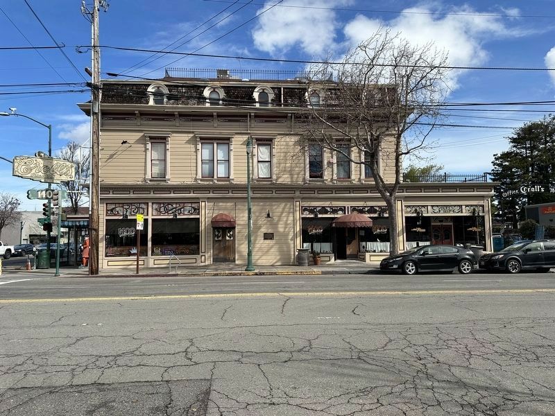
In 1883, promoter and entrepreneur Johnny Croll purchased the saloon and soon the entire building became known as Croll's. This site was famous as the . . . — — Map (db m243880) HM
NEWSPAPERS were the main source of
public information before the introduction
of radio and television. The Bay Area was
home to several daily newspapers and the
larger publishers produced as many as five
editions released throughout the day. . . . — — Map (db m145341) HM
Traces of Alameda Japantown
Opening up shops on Park Street
Traces of a small close-knit Japanese community remain, yet little is known of the Japantown that once thrived in Alameda. At the turn of the 20th century, Issei, first generation . . . — — Map (db m220123) HM
Incorporated on August 24, 1926
Joseph L. Rosefield was the inventor of hydrogenated peanut butter. Before this process was developed, peanut butter would separate and quickly spoil. Mr. Rosefield received a patent for his process in 1923 . . . — — Map (db m163095) HM
The explosive powder industry developed around San Francisco during the Civil War to
supply California's gold mines. A powder plant opened at Albany's remote Fleming Point in
1879. Others on the north side of Albany Hill followed. Nobel Depot, . . . — — Map (db m174552) HM
This sculpture honors the Gill Family rose nursery that operated
during the late 19th to early 20th century in the area extending west
from San Pablo Avenue to Ocean View Park. It also honors the original
name of the City of Albany, which was . . . — — Map (db m137060) HM
Charles Manning MacGregor built approximately 1,500 homes in Albany, mostly in the 1920's and 1930’s. These homes, many featuring a Mediterranean style, originally sold for under $5,000 and can still be seen around town, giving Albany its own . . . — — Map (db m137101) HM
The Juice Bar Collective
was opened in 1976.
One of Berkeley's first
worker-owned restaurants
which sought to bring
together home cooked
food and social justice to
serve the community.
In memory of
Clea Maciver
A . . . — — Map (db m218917) HM
In the early 20th century, a thriving manufacturing district grew up in southwest Berkeley. This is the site of a former saltwater pump house, located on what was once the east shoreline of San Francisco Bay. The pumps supplied water used in the . . . — — Map (db m54669) HM
The Star Grocery, one of Berkeley's oldest and most beloved
family-run businesses, was founded in 1922 by Greek immigrant
brothers Nick and Jim Pappas. They originally hand delivered groceries
in wicker baskets which, as the business flourished, . . . — — Map (db m154319) HM
City of Berkeley Landmark
designated in 1978
James Loring Baker was an early Berkeley landowner, developer, and civic leader. He was one of the signers of the incorporation papers for the Town of Berkeley and it was he who delivered them to . . . — — Map (db m54332) HM
Listed on the National Register of Historic Places
For nearly a half century, this steel frame and concrete structure, clad in brick and terra cotta, was Berkeley’s only “skyscraper.” Walter Ratcliff, highly respected for his fine . . . — — Map (db m52316) HM
City of Berkeley Landmark
designated in 2006
This reinforced concrete building with its articulated brick facade and simple classical detailing was built for Harvey and Marie Ennor at a time of energetic downtown development. They expanded a . . . — — Map (db m54337) HM
City of Berkeley Structure of Merit
designated in 2000
William Wharff, Architect, 1909
Renovation, The Bay Architects, 2001
During Berkeley's early 20th-century development boom, the F.D. Chase Real Estate
Company constructed this . . . — — Map (db m174424) HM
City of Berkeley Landmark
designated 1985
The Farm Credit Administration built this structure to house federal agricultural banking and financial agencies, including one of the 12 Federal Land Banks that assisted Depression-era farmers. Features . . . — — Map (db m54258) HM
Stone and Smith, Architects 1901
Jim Novosel: The Bay Architects 1998
Berkeley’s transit pattern was established in 1876 when Francis Kittredge Shattuck and James L. Barker brought a spur line of the Central Pacific (later Southern Pacific) . . . — — Map (db m52378) HM
Listed on the National Record of Historic Places
In 1877, English immigrant John G. Wright founded the Golden Sheaf, Berkeley's first wholesale/retail bakery. The original bakery, with a public dining room, stood around the corner on Shattuck . . . — — Map (db m50360) HM
James W. Plachek, Architect 1917
Jim Novesel: The Bay Architects 1994
This small commercial building was built for William Heywood, son of Berkeley pioneer Zimri Brewer Heywood. The upstairs was used as the architectural offices of James W. . . . — — Map (db m52382) HM
City of Berkeley Landmark
designated in 1983
This Zig-Zag Moderne building, designed for the sale and servicing of Buick automobiles, captures the glamour, rising affluence, and sophistication of the post-World War I era. Charles Howard, who . . . — — Map (db m54334) HM
Charles Dickey, whose firm designed the Claremont Hotel and who practiced architecture extensively in California and Hawaii, designed this building with two residential floors above commercial storefronts. From 1921 to 1935 the ground floor was . . . — — Map (db m52313) HM
In 1876 the Central Pacific (later Southern Pacific) Railroad expanded into downtown Berkeley. What is now Shattuck Square was the site of freight yards; Berkeley Station was located on the smaller block to the south. By 1903, as the business . . . — — Map (db m52384) HM
Samuel H. Kress began his chain of retail stores around 1900 and soon these “five and dime” variety stores dotted downtowns across America. Kress’s own company architects designed stores of high quality and adapted them to fit into the . . . — — Map (db m52380) HM
Shattuck Square is a group of three buildings constructed on the site of a former railroad freight yard, as a northern anchor to Berkeley’s historic downtown commercial district. It is the city’s only work by the San Francisco architectural firm . . . — — Map (db m52391) HM
City of Berkeley Landmark
designated in 1998
By 1900, downtown Berkeley had developed around Shattuck Avenue, its main street. On this site, owned by John Hinkel, stood a brick livery stable run by John Fitzpatrick, the early operator of the . . . — — Map (db m54346) HM
Bill Gulley started "Bill's Model Shoe Shop” here in 1934,
after his previous business enterprise of bootlegging ended
with the repeal of Prohibition. When he died in 1966, his
daughter, Mary Jane "Peggy” Casey, and her daughters . . . — — Map (db m154320) HM
City of Berkeley Landmark
designated in 1982
John and Margaret Gorman moved their furniture and upholstery shop to this location in 1880. It is one of Berkeley's oldest commercial buildings and a surviving example of the . . . — — Map (db m29371) HM
City of Berkeley Landmark
designated in 2005
This corner store was built for Stella King’s dry goods business and upstairs residence. Until the shop closed in 1923, it was a gathering place where neighbors could find everything from sewing . . . — — Map (db m54722) HM
A revolution began here in 1966 when Alfred H. Peet (1920-2007) opened his first coffee roastery and store. Arriving in San Francisco in 1955, “Mr. Peet” was dismayed by the poor quality of coffee in his adopted country. He had learned . . . — — Map (db m54188) HM
City of Berkeley Structure of Merit
designated in 1988
German immigrant George Hunrick built one of Berkeley’s many neighborhood groceries on this site when the north Berkeley hills were in an early stage of development. In those days before home . . . — — Map (db m54189) HM
City of Berkeley Landmarks
designated in 1986
Allenoke is the only large estate remaining near the northern edge of the University of California campus. It was designed by Ernest Coxhead for Allen Freeman, President of the Bank of Oakland. . . . — — Map (db m53888) HM
This building, thought to be Berkeley’s oldest remaining structure, originally stood on the Contra Costa Road, now San Pablo Avenue. Built by Captain William J. Bowen when the area was sparsely populated, it served as an inn, saloon, grocery . . . — — Map (db m53831) HM
(Rehabilitated and Partially Reconstructed in 1986. William Coburn, Historic Architectural Consultant)
In the 1850s, Gold Rush-era farmers and merchants began settling in this rural bayside area. Delaware Street connected Jacob’s . . . — — Map (db m52299) HM
City of Berkeley Landmark
designated in 1985
Built by a real-estate developer during the East Bay building boom that followed the 1906 earthquake, this corner store anchored the southwestern boundary of the neighborhood once known as Regents . . . — — Map (db m53833) HM
The whaling gun below this plaque came off the ship; “Cody.” Gib Hunter was the Captain of the ship and was the last of the whalers to operate off the West Coast. Captain Hunter presented this whaling gun to Bud Spenger. — — Map (db m155984) HM
Clam chowder, baked beans and 10¢ beer – these and fish dinners drew crowds to fabled Spenger’s. It all began in the 1860s when Johann Spenger from Bavaria started fishing in the Bay. The gabled structure he built here housed his business and . . . — — Map (db m52303) HM
City of Berkeley Landmark
designated in 1986
Over the years this complex housed Cooper Woodworking, the Sperry Flour Company, the American Photoplayer Company, and other industrial and manufacturing enterprises. American Photoplayer manufactured . . . — — Map (db m53818) HM
City of Berkeley Landmark
designated in 1977
Listed on the National Register of Historic Places
This small-scaled complex of one-and two-story buildings is a surprise on a busy street. Arranged along a brick walkway through a garden court, . . . — — Map (db m53829) HM
This building was originally part of the small commercial district that grew up around Dwight Way Station where Shattuck Avenue commuter trains intersected with the horse-car line that ran up Dwight Way to the California Schools for the Deaf and . . . — — Map (db m29581) HM
Founded in 1945 by local sports hero Melvin Reid and his wife Betty Reid, Reid’s Records was one of the first Black-owned record shops in California and one of the few shops of any kind where African-American music could be purchased before the . . . — — Map (db m152805) HM
City of Berkeley Landmark
designated in 1982
In the early 20th century, this was one of two banks anchoring the busy Lorin business district’s streetcar intersection. The building remained a bank until the 1980s. Its architecture combines a . . . — — Map (db m53815) HM
City of Berkeley Landmark
designated in 1981
Fred Turner Building
Julia Morgan, Architect
Christian M. Teigland, Builder, 1940
This elegant commercial building, featuring two projecting storefront bays, . . . — — Map (db m238722) HM
In 1959, Morris (Moe) Moskowitz and his wife, Barbara, opened a small paperback
bookshop on Shattuck Avenue. They soon moved to Telegraph Avenue where Moe's
Books evolved into a renowned emporium featuring hundreds of thousands of books.
Moe's . . . — — Map (db m136179) HM
This station was constructed as an
Exxon Super Service Station in 1933.
It was a business venture of
longtime Berkeley elementary
school teacher, Sue Irwin.
Built in the California Mission
Style it reflects the look of
railroad . . . — — Map (db m171532) HM
Berkeley History
Reflecting West Berkeley’s early industrial heritage, this plant remains one of the city’s largest brick buildings. Once used to produce chemicals for a cluster of nearby industries that manufactured soaps, cleaning agents, paper . . . — — Map (db m53812) HM
In the 1930s pharmacist and civil rights activist Dr. William Byron
Rumford (1908–1986) served as the first black professional at
Oakland's Highland Hospital. In 1942 he purchased a pharmacy in
Berkeley and, after constructing this . . . — — Map (db m154343) HM
For 86 years a favorite congregating spot. Built by John Green in 1860, with a balcony over the porch and a gabled roof. A famous cross-roads stop and transfer point on the Oakland-Stockton and Martinez-San Jose stagecoach routes intil the 1890's . . . — — Map (db m59944) HM
Charles Daugherty sold this building to George Kolb in 1905 for $25.00. While Kolb owned and operated Dublin’s General Store he used the barn for storage. In 1912 he moved it from its original location on Dublin Boulevard to his property on Dublin . . . — — Map (db m201559) HM
Directly across the railroad tracks, where the big blue IKEA store stands today, was once the site of Emeryville's
oldest and largest industrial facility, Judson Manufacturing, founded by Egbert Putnam Judson in 1882.
Judson was born in . . . — — Map (db m238936) HM
For over 85 years, from 1920 to 2007, the area in front of
you was the site of a large Sherwin-Williams paint factory.
The only remaining structure is "Building I-31", the brick
and concrete building at Horton Street and Sherwin Avenue.
The . . . — — Map (db m238890) HM
In the second half of the 19th Century, when Emeryville was transitioning from a former Mexican cattle ranch into
a future American city, two abutting property owners played major roles in its development: Joseph S. Emery and Edward Wiard. In . . . — — Map (db m238970) HM
With the discovery of gold in California, the town around the Mission San Jose became the gateway and provision center for the “49er” on his way to the Southern Mines.
To meet these demands, the firm of Strauss and Co. was founded by . . . — — Map (db m64904) HM
This property (43327 Mission Blvd.) was developed in 1895 by Daniel Baker for a livery business. The enterprise continued under the ownership of Edward Coffany, William Rose, and then Andrew Kell, at least until 1916. By 1924, the building was . . . — — Map (db m220207) HM
Washington Hotel originally located across the street as a two story adobe building. Destroyed by the 1868 earthquake. Rebuilt on the present site in the same year.
The building has served as a hotel, stage stop, state library, and present . . . — — Map (db m54668) HM
Boxed Tree Forest
These oak trees were planted in boxes waiting to be sold when the Roedings operated California Nursery Company. Eventually the trees rooted into the ground creating a unique forest of boxed trees. Over the years, local . . . — — Map (db m208707) HM
The primary purpose of the California Nursery Historical Park Master Plan is to tell the story of the California Nursery Company to current and future generations through the sharing of the site’s remaining historic buildings, majestic . . . — — Map (db m208557) HM
The California Nursery property includes noteworthy landscape features, such as the many mature trees, in addition to historically and architecturally significant buildings like the garden store. Unfortunately, due to years of use and multiple . . . — — Map (db m208714) HM
Site of flour mill, Niles. Built 1853 by Don Jose De Vallejo, brother of General Vallejo, on his Rancho Arroyo De La Alameda.
Niles was once called "Vallejo Mills". Stone aqueduct carrying water for mill parallels Niles Canyon Road. — — Map (db m154369) HM
This winery was founded in 1869 by Leland Stanford, railroad builder, Governor of California, United States Senator, and founder of Stanford University. The vineyard, planted by his brother Josiah Stanford, helped to prove that wines equal to any in . . . — — Map (db m100554) HM
As part of the City of Hayward’s commitment to sustainability, we promote healthy, environmentally-sound landscape practices.
Since 2009, the City required that large civic landscape projects be verified as Bay-Friendly Rated Landscapes. This . . . — — Map (db m208210) HM
This park is dedicated to the Hunt Brothers Cannery and the people of Hayward whose industry and loyalty made the cannery a success.
Established on this site in 1896 by Will and Joseph Hunt. By the mid 1940's, Hunt Brothers Cannery became the . . . — — Map (db m195817) HM
Salt is an important compound. Our lives depend on it and the economy
of many cultures thrive on its trade. Salt harvesting has a long history in
the Bay Area, beginning with the Ohlone Indians. Early salt production
included gathering salt . . . — — Map (db m177228) HM
Owner of the first Japanese restaurant in Hayward California (Kokeshi)
A caring and giving person, known for her generosity and kindness. She exemplifies the American dream. We will all miss her and never forget her. — — Map (db m207577) HM
THE PILINGS IN FRONT OF YOU once held structures of
the Oliver Salt Company. After the gold rush, demand for salt
soared for use in ore refining, livestock raising, paper pulping,
and food preservation. Many former gold-seekers, . . . — — Map (db m174885) HM
Marker Once:
Once plentiful on California beaches, western snowy plovers now face extinction due to habitat loss from coastal development and beach recreation. Fortunately, dry salt ponds offer these sparrow-sized shorebirds an . . . — — Map (db m207071) HM
In the late 1870’s, inventive Andrew Oliver studied the drawings of Archimedes (287-212 B.C.E) and built these wind driven screw pumps based on the ancient designs.
The wooden blades rotate in the wind, which turns the screw shaft visible under . . . — — Map (db m207726) HM
Dramatic reductions in tidal wetlands over the past 200 years, due to urban development, agriculture, and salt production, resulted in significant declines in marsh-dependent wildlife. In addition to providing critically important habitat for fish, . . . — — Map (db m207017) HM
Marker One:
Balancing the needs of people and wildlife has long challenged Californians. Gold Rush-era settlers believed the best value of Baylands came from converting them to salt ponds, housing, or other human uses. Today we recognize . . . — — Map (db m207078) HM
WHEN THE PONDS AROUND YOU were first built,
producing salt by solar evaporation required intense labor and
a lot of time. Workers had to move seawater from San Francisco
Bay (only 2.5% salt content) through a series of evaporation
ponds to . . . — — Map (db m174878) HM
Olivina is the name of the estate Julius Paul Smith built in the Livermore Valley. He and other local entrepreneurs recognized the similarities in climate and soil to the fine wine regions in Europe. The wines produced from their Valley estates . . . — — Map (db m196904) HM
Contractor: Rasmussen & Bennett
D. D. Emmenger was partner in Johnson and Emmenger Dry Goods from 1901 to 1913; he bought out his partner in 1913 and continued business until 1920. The house was purchased by Frieda Wente Tubbs in 1923. — — Map (db m196814) HM
Service Station and Car Dealership
Situated on the Original Route
of the Lincoln Highway
————————
City of Livermore
Historic Preservation Site
Dedicated July 1996
Operated by
The . . . — — Map (db m19994) HM
Julius Paul Smith was born in Wisconsin in 1842. After fighting in the Civil War, he tried his hand in the farm machinery business and the grocery business. He married Miss Sarah Barker of New York in 1870 and soon headed west.
Julius joined . . . — — Map (db m196907) HM
Coast Manufacturing and Supply Co. moved to this site in the early 1900s and produced fuse line for explosives. Between 1913 and 1926 Coast hired Chinese immigrants to work in the powder houses located just to the north of this grove of trees. These . . . — — Map (db m198579) HM
Agathon Lydiksen operated a tire
shop in half of this building.
The other half was a plumbing
supply store. Last automotive
services structure downtown in
the east end of First Street. — — Map (db m194782) HM
The Livermore Fire Brick Works used this site to make bricks from local clay from 1910 until 1949. Some of those bricks have been used in constructing the base for this plaque. — — Map (db m199556) HM
Built by pioneer merchant Charles C. Wilder, a contractor and homebuilder whose business contributed to the city's economic development. — — Map (db m198001) HM
[Side 1:]
William M. Mendenhall
1823 – 1911
Pioneer settler, a descendant of Quakers who emigrated from England with William Penn. He crossed the plains on horseback in 1845. Was a member of Fremont’s Battalion in 1846 and . . . — — Map (db m196958) HM
Western history owes the Carter Brothers a great debt, for they were the general contractors for the first six narrow gauge railroads in California. From 1874 to 1902 they built freight, passenger, cable and street cars. Their plant became Newark's . . . — — Map (db m94310) HM
Regional Historic
Mechanical Engineering Landmark
Wind-Powered Archimedes Screw-Pump
ca. 1890
Newark, California
This late example of the wind-driven Archimedes screw-pump shifted brine from on salt concentrating pond to one . . . — — Map (db m71365) HM
This building was originally constructed as the Niles Branch of the Bank of Alameda County. Its doors opened on Monday, September 23, 1929. The construction was considered a “new modern building” that would be “a model of . . . — — Map (db m24455) HM
Oakland Canneries
By the early 20th century, harbor improvements, expanded port facilities, and transcontinental rail service had made Oakland one of the state's leading exporters of processed food of all kinds: canned, dried, bottled, . . . — — Map (db m92788) HM
The West was pioneered by remarkable men, one of whom was Francis Marion “Borax” Smith. A Wisconsin farm boy, he became one of the great entrepreneurs of California and Nevada. By 1890 he dominated the borax industry and his trademark, the 20-Mule . . . — — Map (db m72139) HM
Oakland built the 9th Avenue Terminal to load and unload
break-bulk cargo – goods packed in individual crates,
barrels, and bags, rather than in standardized containers.
It's a method of shipping that requires a lot of manpower, and for . . . — — Map (db m163098) HM
The opening of the Panama Canal in 1914 made way for new
trade routes that led to a shipping boom in the post-war
world of the 1920s. By 1925, Oakland was ready to capitalize
on growing international commerce. On November 10, the
people of . . . — — Map (db m163097) HM
Latham Square is actually a triangle, an accidental space created
by the meeting of new and old roads. Broadway did not extend
above 14th Street until the late 1880s, when it was needed to
channel the city's expansion to the north. Telegraph . . . — — Map (db m160466) HM
Latham Square is located in the
historic shopping and transportation
hub of downtown Oakland. The name
dates from dedication of the Latham
Fountain in 1913. The fountain was a
gift to the City and the local SPCA
from Edith and Milton Latham . . . — — Map (db m160463) HM
This bay front site originally bordered Ohlone Indian settlements. In 1820 the Spanish crown granted it to Luis Maria Peralta. In 1842 it was given to his son Antonio Maria Peralta. The area was acquired by Horace Carpenter (first mayor of Oakland), . . . — — Map (db m71212) HM
The California Cotton Mill was one of Oakland’s earliest and largest industries.
Jingletown was named for the mill workers’ habit of jingling coins in their pockets on payday.
At its height, the mill had 600 to 700 employees and 20 to 30 . . . — — Map (db m71211) HM
Creating a Harbor
Spreading before you is the Oakland Estuary. This sheltered inlet of San Francisco Bay was once fringed by broad marshes and shallow tidelands which became mud flats at low tide. A rich wildlife habitat, the estuary was a . . . — — Map (db m72098) HM
This building incorporates elements of the 1946-47 Connell Motor Company building.
Located on the former site of St. Mary's College (1889-1929), the building was developed
by W. A. Connell as an Oldsmobile dealership, showroom, and service garage. . . . — — Map (db m193369) HM
Oakland Point
Originally known as Oakland Point, for the westward bulge of the shoreline, this area was later called Prescott after the school. It developed from 1869 in tandem with the trans-continental railroad. The Central Pacific/Southern . . . — — Map (db m177514) HM
American Bag and Union Hide Company pioneered the vacuum cleaning and machine mend-
ing of used burlap bags which it resold as "Guaranteed Amerbags” with an unconditional guarantee, an
unusual practice at the time. The company also made new . . . — — Map (db m145515) HM
This one story brick warehouse served as the showroom and service garage for The Autocar
Sales & Service Company, an Ardmore, Pennsylvania car and truck manufacturer that pioneered the
mass production of forward control trucks (cab-over design). . . . — — Map (db m145495) HM
The Cincinnati-based C. L. Greeno Company built the C. L. Greeno Pacific Coast
Headquarters warehouse to receive upholstery and bedding supplies via rail from its Ohio factory for distribution throughout the area west of Denver. Favorable rail . . . — — Map (db m145493) HM
The marine terminal you are facing is the easternmost of the Port of Oakland’s container shipping facilities. Howard Terminal is operated as a joint venture of SSA Terminals and Matson Navigation Company, the principal carrier of containerized . . . — — Map (db m71327) HM
A tiny wholesale grocery firm was the first occupant of this warehouse built on speculation
for developers Hyman Davis and M. Parker. Founded in San Francisco in 1896 by Samuel Sussman, and
Gustav and Samuel I. Wormser, Sussman Wormser & Company . . . — — Map (db m145505) HM
2805 entries matched your criteria. The first 100 are listed above. Next 100 ⊳