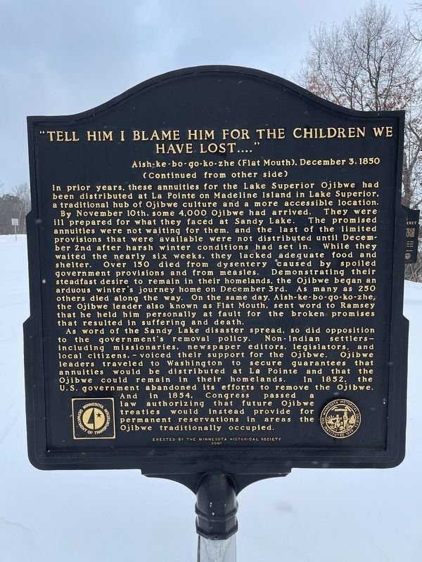
In late 1850, some 400 Ojibwe Indians perished because of the government’s attempt to relocate them from their homes in Wisconsin and Upper Michigan to Minnesota west of the Mississippi River. The tragedy unfolded at Sandy Lake where thousands of . . . — — Map (db m206878) HM
Early water transportation on the Upper Mississippi River from St. Paul to St. Louis was hindered by fluctuating water levels. In 1878, the Corp of Engineers studied the impact of a reservoir system on the river. The study resulted in the building . . . — — Map (db m207887) HM
Of the American Fur Company was established near here about 1830, after an earlier location further south at the Northwest Company’s station had been abandoned.
William A. Aitkin for many years was a leading trader in this region. Indian . . . — — Map (db m207745) HM
To the native Anishinabe (Ojibwe) and to the white fur traders who bartered with them in the late 1700s and early 1800s, no Minnesota lake had a more strategic location than Big Sandy Lake, which stands at the intersection of two major trade . . . — — Map (db m210859) HM
The white pine forests fell to the logger's ax in the northern Rum River pineries, "Seventy mills in seventy years could not exhaust the white pine I have seen on the Rum River" predicted Daniel Stanchfield, a lumber-wise timber cruiser . . . — — Map (db m70937) HM
The Rum and the Mississippi were river highways for the Dakota, the Ojibwa, European explorers, traders and settlers.
Between 1850 and 1870 the Rum and the Mississippi became "working rivers" for lumbermen. In the fall loggers traveled . . . — — Map (db m70914) HM
Robert W. Akin (1871-1920) came to Anoka in 1898 and began working as a cashier in the State Bank. His property a few blocks south of Main Street on the east bank of the Rum River was said to be one of the "most picturesque sites in the . . . — — Map (db m162173) HM
The first dam was built here in 1853 of logs and earth fill by Caleb and W.H. Woodbury. It washed away in high water in the Spring of 1854. A second dam was built in 1854 by James McCann. This dam and its pool provided 5 sluiceways for water . . . — — Map (db m70264) HM
Built in 1872 by W.D. Washburn & Co., the mill had an annual production of 16 million board feet of lumber. Combined with the planing mills, dry kilns, etc., the mill employed about 125 men. For 17 years logs from the headwaters of the Rum . . . — — Map (db m242327) HM
Native peoples and traders met at a trading post constructed across the Rum River from The Point in 1844 by Joseph Bellanger. The Ojibwa brought furs and skins to trade for copper cooking pots, cloth, blankets, decorative beads and iron . . . — — Map (db m70921) HM
Why Settle Here? Looking for Work
Timber was a resource that drew many west and in 1847, surveyor Daniel Stanchfield noted, "Seventy mills in seventy years couldn't exhaust the white pine I have seen on the Rum River". The rivers . . . — — Map (db m70982) HM
The Rum River, a 148 mile river of gradual grade, is rich in history. The French explored it. The Chippewa and Sioux fought along it, and the pine logs that helped build the cities of the Midwest were floated down it during the lumber boom of the . . . — — Map (db m94721) HM
Through woodland and prairie, along riverbanks and through sloughs, the mixed-blood American and Canadian buffalo hunters called Metis blazed trails with their oxen and squeaky-wheeled wooden carts. They carried buffalo robes and pemmican from . . . — — Map (db m206932) HM
Bad Medicine Lake also called the Lake of the Valley, was originally known to the Ojibway Indians as Ga-wimbadjiwegamag (Lake lying in a mountain depression). Among the many stories about the name’s origin are legends of serpentine fish and . . . — — Map (db m207258) HM
June 1911 Bemidji Commercial Club entertains Louis Hill, Governor Eberhart, and others at Markham Hotel for dinner and tours them around the Bemidji area hoping Hill will commission a new Great Northern Depot in Bemidji. April 24, 1912 . . . — — Map (db m235292) HM
Norway Pine planted in memory of Harry Davidson 1894 — 1983
Harry and Vera Davidson operated Sunset Lodge on this site from 1938–1970. It included a café & bar, 9 cabins, and boat rentals. — — Map (db m199596) HM
Waskish was named by the Chippewa Indians who hunted, fished, and gathered wild rice along the Tamarack River. The Ojibway word for deer is Wawaskishi, which was shortened to Waskish by the early pioneers. The old town site was located at the . . . — — Map (db m181008) HM
Early European explorers were drawn to the Minnesota River Valley's unique characteristics just like the Native Americans before them. French Fur Trader and Explorer Pierre Charles Le Sueur was the first recorded European explorer of the . . . — — Map (db m237541) HM
European settlers began arriving in the area in the 1850s. The Treaty of Traverse des Sioux, signed July 23, 1851, allowed settlers to claim land that had once belonged to the Dakota. In 1852, Parsons King Johnson and Henry Jackson claimed the . . . — — Map (db m236258) HM
Rensselaer Dean Hubbard, successful entrepreneur and civic leader, built his house on Broad Street in three stages: in 1871, 1888 and 1905. During the
late 19th century, many of Mankato’s captains of industry and commerce established their . . . — — Map (db m66338) HM
Built in 1857 in Mankato Township and was moved to this site, which was once the site of the fur trading post of Henry H. Sibley by the Blue Earth County Historical Society in 1931. — — Map (db m66845) HM
On October 3, 1887 the City of Mankato purchased 120 acres for $13,088 at the confluence of the Blue Earth and Minnesota Rivers to create Mankato’s first park. Sibley Park was named for Henry Hastings Sibley (later Minnesota’s first Governor) who . . . — — Map (db m66483) HM
On April 8, 1885 Chief Engineer Blunt of the Winona & St. Peter Railroad Co. announced that the railroad had decided to build a side track between New Ulm and Sleepy Eye for the purpose of receiving grain. The site was known only as "Siding Number . . . — — Map (db m67411) HM
In 1899, the Iowa and Minnesota Land & Townsite Company circulated a petition to locate a railroad station in Lake Hanska Township. The petition was signed by 77 people and on October 9, 1899 the village of Hanska was platted in section 24 by Harry . . . — — Map (db m66468) HM
This structure is a replica of many such stabburs found in Norway. There are several variations. "Stabbur" translated means store house.
Benefactors: James & Ferdi Amundson estate.
These Lake Hanska farmers were descendants of Norwegian . . . — — Map (db m68264) HM
In 1857, settlers platted a townsite in Section 14 of the Leavenworth area. During the next year, Dr. J. B. Calkins established the post office and became its first postmaster. Leavenworth Township was legally organized on April 16, 1859. Seven . . . — — Map (db m68025) HM
The town gained a new venue for public events in 1873 with the opening of Arbeiter Hall. The local Arbeiterverein, or Workers' Association, organized in 1871, primarily as a workers' insurance association. The two-story brick building had a . . . — — Map (db m67093) HM
The Brown County Bank is among the oldest commercial properties within the district. As the local economy recovered from the devastating effects of the Dakota Conflict, the city found itself without a bank following the demise of the First . . . — — Map (db m66879) HM
This three-story building is a fine example of Queen Anne commercial architecture. The original southern section was erected in 1892 for the Buenger Furniture Store, while the corner building was constructed in 1902.
Louis Buenger Sr. . . . — — Map (db m68117) HM
Rosa Schnobrich opened the City Meat Market in 1907 with the advertising slogan, "Better Meats, Cleaner Meats, and Quicker Service." Her sausages, in particular, proved popular, and soon her shop began supplying a network of wholesale dealers . . . — — Map (db m68267) HM
For years, the Crone store was the largest mercantile establishment in New Ulm. In 1857, Theodore Crone Sr. opened his general store at the corner of Broadway and Center Streets. Twelve years later, he erected this building, adding a . . . — — Map (db m66864) HM
The Dacotah House, located on this site, was built in 1859 by Adolph Seiter and Frank Erd. Adolph's wife, Helena Erd Seiter soon established her fame in the kitchen. During the Dakota Conflict of 1862, Helena fled in a wagon with her children to . . . — — Map (db m66377) HM
Frank Erd and his wife, Louise, came to New Ulm from Cincinnati. Frank, whose father was an architect, erected a substantial store, one of the few brick buildings in the city. The Brown County supervisors kept their offices in Erd's building, . . . — — Map (db m66897) HM
Frederick Forster came to the United States in 1850 and taught school in New York. He moved to New Ulm in 1858, where he continued teaching, becoming the city's postmaster in 1861.
In 1860, Forster purchased this lot and the following . . . — — Map (db m68227) HM
Frederick Forster, who conducted the New Ulm Pottery here with Frances Gommel, was also the Postmaster. This building, used as a combined pottery works, Post Office and dwelling, was a very important defense outpost in 1862.
During the . . . — — Map (db m162175) HM
The first structure built on this site was the Minnesota Haus, the first hotel in New Ulm, built in 1856 by Phillipp H. Gross. That early structure was destroyed and in 1860, on the same sight, Gross built the Union Hotel, a two and a half story . . . — — Map (db m67981) HM
West Newton in 1870 was a thriving town, serving riverboat travel on the Minnesota River. It consisted of a hotel, a livery stable, a brewery, a sawmill, a wagon works, two blacksmith shops, three saloons, and many dwellings that made the town an . . . — — Map (db m66238) HM
The Kiesling House is one of the three downtown buildings in New Ulm to survive the Dakota War of 1862. Frederick W. Kiesling, blacksmith and ferrier, had built the modest frame house ($125) the year before the outbreak of the war. In August of . . . — — Map (db m65497) HM
Frederick Beinhorn and Wilhelm Pfaender, pioneer founders of the prairie colony of New Ulm, were cut of the same cloth. Both came to America from Germany after the 1848 Revolution in Central Europe failed to unite German peoples under a new frame of . . . — — Map (db m65694) HM
On this site in 1859 Frederick Roebbecke built a seventy foot high wooden windmill for grinding corn and grain. Situated on a prominent ridge, it commanded an excellent view of the scattered settlement. Barricaded with sacks of flour and grain, the . . . — — Map (db m65400) HM
Henry A. Subilia, a native of Jean, Italy, constructed the Waraju distillery in 1861. The construction cost total of $8,000, plus $2,000 for furnishings. The building required approximately 200,000 bricks and measured 72 feet x 46 feet. It obtained . . . — — Map (db m153916) HM
Searles, a small community in Section 21 of Cottonwood Township, was platted on October 10, 1899, by Harry and Anna Jenkins. It was a railroad station point named by officials of the Minneapolis and St. Louis Railroad.
The original plat . . . — — Map (db m67914) HM
The mill, built in 1867 by John Heimerdinger, was down 1/4 mile from Golden Gate on the Ruhe-Heim Creek. It was powered by a pond kept full by many wells, dug by hand. Wheat was ground by stones into flour and feed. — — Map (db m71062) HM
One hundred miles north and west of Duluth lies the Iron Range. North America's largest iron ore region consists of three major iron ranges: the Vermillion, the Mesabi, and the Cuyuna. The Vermillion was the first to ship iron ore from Minnesota . . . — — Map (db m44038) HM
Carver Historic District
has been placed on the
National Register
of Historic Places
by the United States
Department of the Interior
Funk Hardware Store
ca. 1880 — — Map (db m79278) HM
Carver Historic District
has been placed on the
National Register
of Historic Places
by the United States
Department of the Interior
Minnesota Valley Oil Co.
1925 — — Map (db m75255) HM
Carver Historic District
has been placed on the
National Register
of Historic Places
by the United States
Department of the Interior
Stephen Kult Clothing Store
1871 — — Map (db m79125) HM
This property
has been placed on the
National Register
of Historic Places
by the United States
Department of the Interior
Brinkhaus Livery Stable
1890 — — Map (db m59555) HM
City Square Park
City Square in Chaska has always been a gathering place and the heart of this community. The land was set aside for public purpose in 1852 in the original plat. Early settlers in Chaska found six earthen mounds on this . . . — — Map (db m63707) HM
By 1804 Jean B. Faribault was trading in furs for the Northwest Company near the "Little Rapids" of the Minnesota River, 5 miles south of this point, and in this vicinity. His fur post of 1824 on the site of Chaska became the nucleus for the first . . . — — Map (db m41051) HM
The Brick Farmhouse
The brick farmhouse before you was built by the Grimm family sometime around 1875. It replaced a small log cabin where the family had lived since they first acquired the property in 1857. More than just a new home, this . . . — — Map (db m212381) HM
There was a time, not long ago, that harvesting meant long hours of hard manual labor. The process of harvesting grain meant first cutting the grain with a cradle scythe. The stalks were then gathered by hand and tied into bundles. Groups of 15-20 . . . — — Map (db m163406) HM
Minnie Christina Peterson Upon her father's death in 1914, Minnie became the sole proprietor of the Watertown General Merchandise Store. It's been said that Minnie was "way ahead of her time for a business woman." She passed away in a tragic . . . — — Map (db m213045) HM
Civil War 100 Watertown pioneers served in the Union Army during the Civil War. They served in infantry, artillery, and cavalry regiments. By 1865 there was not a man left in the area between the ages of 18 and 45; the town remained at a . . . — — Map (db m213070) HM
The arrival of a train in a small town was an important event, bringing new settlers, visitors, mail, news, and goods faster and more often than in the days before the railroads. Pine River wasn't the only place in Minnesota that changed once the . . . — — Map (db m189381) HM
In the early 1900s before the automobile, tourists could book round-trip railroad passage from Minneapolis to Walker for just fifty cents! At its peak in the 1970s, there were over 200 Ma & Pa establishments serving the lake — mostly simply fish . . . — — Map (db m235794) HM
The name Leech Lake Village was changed to Walker, Minnesota when a lumber baron from Ohio by the name of Thomas B. Walker came to the area in 1862 and began buying up all the timberland around the area. The Village of Walker was named after him and . . . — — Map (db m235798) HM
The fur-trade industry began in our country in the 1600s and lasted into the 1800s. Fur hats and accessories became a symbol of success in Europe and created the demand which drove the fur trade. The original fur traders in the Leech Lake Area were . . . — — Map (db m235799) HM
Today, the economy of Walker and The Leech Lake Area is dependent upon the visitations of the entire family. The small fish camps have given way to the large resorts that cater to a full schedule of events for all ages. Our little town has become . . . — — Map (db m235796) HM
Fort Renville, the
headquarters of the fur
trade in this area during
the 1820s and 1830s, was
located at the bottom
of this hill.
Joseph Renville, son of a
French trader and a Dakota
woman, began trading for furs at
Lac qui Parle . . . — — Map (db m176307) HM
The village of Almelund and the Immanual Lutheran Church were established in 1887
Reverse
By Gods grace, the people of Amador Township and with the assistance of the Almelund Lions Club, this Triangle Park was developed in 1987. . . . — — Map (db m232288) HM
Off in the distance, near the river, is a stand of conifer trees. Can you find it? Conifers are trees that produce cones, such as pines, spruces, cedars, firs and tamaracks.
In this part of Minnesota, conifer forests often exist only in small . . . — — Map (db m231375) HM
Logs collected above the dam until they were needed at sawmills downriver.
Photo courtesy of St. Croix National Scenic Riverway (National Park Service)
The Last Log Drive
Large numbers of logs were sluiced . . . — — Map (db m235036) HM
Loggers cutting a large white pine.
From the St. Croix and its tributaries—the Kettle, Snake, Rum, Clam, Trade, and Yellow Rivers—thousands of pine logs were sent downstream. Nearly 100 logging camps upstream supplies logs for sawmills . . . — — Map (db m233538) HM
By 1890, 53 years after logging began in the forests that were predicted to last forever, enough trees were cut in one year along the St. Croix to build 50,000 houses. Hundreds of thousands of people across the Midwest lived in houses made from . . . — — Map (db m233412) HM
In the 1830's, logging companies from the eastern United States were running out of easily-harvested trees to supply the lumber for the growing population of this continent. Then they explored along the St. Croix River, and claimed the forests . . . — — Map (db m233405) HM
Below: Map of the Arrow Line route as advertised.
Above: Portion of an Arrow Line stock certificate.
Construction by the Twin Cities & Lake Superior Railway Company took place in 1907-1909. Forty miles of . . . — — Map (db m229960) HM
So read the local paper in 1904 as engineers surveyed the Saint Croix River in search of a suitable place to build a hydroelectric project. The falls had long fueled the local lumbering and milling industries, but the Minneapolis General Electric . . . — — Map (db m120099) HM
Old Georgetown A Tranportation Crossroads
In 1857 the Hudson's Bay Company received United States government permission to
ship furs and trade goods across the United States. They contracted with the Burbank
brother's Minnesota Stage . . . — — Map (db m205727) HM
Built by James and Wilhelmina Douglas in 1873 and occupied until 1887, James Douglas ran a steam ship line along the Red River and served as Moorhead's first Post Master. — — Map (db m43831) HM
Red River Transportation The Red River Trails were a set of overland routes linking the cities of Winnipeg and St. Paul and the small forts and settlements between them.From 1820 to the 1870s, the trails were used by Metis freight drivers who . . . — — Map (db m100838) HM
This replica of the original Wegmann Store was built in 1977 as part of an ongoing summer crafts program to demonstrate log cabin construction. The replica was built by craftsperson Christopher Alpine from Lengby, Minnesota. While the original . . . — — Map (db m155674) HM
Originally made from cedar and birch bark, the Canot du Nord functioned as the workhorse of the 18th and 19th century fur trade. These birch bark canoes could carry several tons of trade goods and between 4 and 6 voyageurs, the occupational . . . — — Map (db m235254) HM
You are looking across Gunflint Lake at the Canadian shore. This was one of the international routes taken by the voyageurs in the late 1600's into the 1800's. — — Map (db m231493) HM
Henry Mayhew, explorer, prospector, entrepreneur and county commissioner, was credited with developing Gunflint Trail and Grand Marais. Capitalizing on the North Shore's well-established commercial fishing and tourism industries, he constructed the . . . — — Map (db m203209) HM
In 1972 Consolidated Papers, Inc., of Wisconsin Rapids, Wis., ended long distance rafting of pulpwood across Lake Superior. From 1923–1972, Consolidated rafted over two million cords of pulpwood from Minnesota and Canada to Ashland, Wis. Minnesota . . . — — Map (db m203083) HM
Hedstrom Lumber Mill
This 6 acre site, bounded by the Gunflint Trail, County Road 60, and the Devil Track River, was home to the Hedstrom Lumber mill and office from 1914 to 1994. The 4 acre eastern portion, once boulder filled and rough, was . . . — — Map (db m231483) HM
In the 1960s, archeologists discovered here remains of a structure used between 1785 and 1802, unusual because it was built on posts. They found artifacts that match the bills of lading from bales, kegs, and cassettes (small trunks) that were canoed . . . — — Map (db m152972) HM
The Gates are shut always after sunset and...
there are two Sentries keeping a look out all
night chiefly for fear of accident by fire.
John Macdonell, Grand Portage, 1793
This gatehouse was not intended to . . . — — Map (db m152975) HM
"All the buildings within the Fort are sixteen in number...Six of these buildings are Store Houses for the company's Merchandise and Furs, etc., the rest are dwelling houses shops compting and Mess House..."
John Macdonell 1793
"June . . . — — Map (db m153048) HM
The lever fur press, much like the reconstructed model before you, was frequently used at fur trading posts operated by the North West Company. It was simple to operate and could be constructed from wood found near the post. Fur pelts, with . . . — — Map (db m153042) HM
The Grand Portage, or Great Carrying Place, was a key 18th century link between the Pigeon River and Lake Superior, making it also a vital connection between Montreal and the rich fur-bearing lands far to the northwest. Traveled for centuries before . . . — — Map (db m62049) HM
Inside the Historic Depot in front of you are three of the sixteen buildings that once comprised the summertime headquarters of the North West Company. The depot was not a fort but instead a secure transshipment point for valuable furs and trade . . . — — Map (db m152973) HM
Montreal canoemen were hired to paddle to Grand Portage. Once there, each man had to carry several 90-pounds (41-kg) bundles of trade goods and supplies up the Grand Portage to Fort Charlotte, where the bundles were repacked for canoe brigades . . . — — Map (db m153054) HM
Saganaga Lake is located along the Border Route, an ancient travel route between Lake Superior and the interior waters of Lac La Pluie (Rainy Lake) that is often referred to as The Voyageur's Highway.
Saganaga Lake was an . . . — — Map (db m231492) HM
Saganaga Lake is located along the Border Route, an ancient travel route between Lake Superior and the interior waters of Lac La Pluie (Rainy Lake) that is often referred to as The Voyageur's Highway.
Saganaga Lake was an . . . — — Map (db m232520) HM
Trapper's lives were spartan and generally routine.
Before freeze-up, they brought in supplies, cut wood, and weather-proofed their cabins and shelters. Returning in November, they set trap lines along trails looping fifty miles or so through . . . — — Map (db m231548) HM
Founder Stewart C. Mills, Sr. December 6, 1891 – April 8, 1978 Lively Auto Company — 1922 Crow Wing Oil Company — 1924 Mills Motor, Inc. — 1931 Mills Fleet Farm — 1955 Mills Properties, Inc. — 1959 — — Map (db m238261) HM
Named for entrepreneur Cuyler Adams and his faithful dog Una, the Cuyuna Ranges lies at the westernmost edge of a ring of iron ore that circles Lake Superior. The smallest of Minnesota’s three northern iron ranges, the Cuyuna was also the last to be . . . — — Map (db m43934) HM
This picnic shelter is dedicated to Don Nelson, who served Crow Wing County, Sibley Township and the City of Pequot Lakes as a dedicated employee and volunteer. Don Nelson began his career as a logger, and operated a saw mill in Sibley Township . . . — — Map (db m237487) HM
As Hastings quickly grew and settlement in the area increased, this port city soon became the commercial center for Dakota County farmers.
Farmers brought wagons full of crops to the Hastings market, and then returned home driving wagons full . . . — — Map (db m47843) HM
A Small Area with a Big Impact
During the late 1800s, downtown Hastings offered a wide range of goods and services to the growing river city, resulting no just in a vibrant economy, but also a visually striking commercial district of fine . . . — — Map (db m198461) HM
This sculpture should not be viewed with realism, but as the artist’s expression of some of the images that helped form the community.
The wagon wheel represents commerce and the progress of life. It is placed in your line of sight so you look . . . — — Map (db m137312) HM
From 1856 to 1865, in its first decade of existence, the city of Hastings grew by 2,500 people, enjoying a boom of settlement also experienced by other cities along the Mississippi.
A steady flow of settlers, including many immigrants, . . . — — Map (db m48361) HM
The Mississippi River has provided a habitat for many species of fish and other aquatic creatures for millions of years. Human modifications of the river have had both positive and negative effects on fish populations here. Many types of fish thrive . . . — — Map (db m49277) HM
The natural river above Hastings was treacherous for steamboats, with a depth that reached only three and one-half feet in some places. The first efforts of the federal government to improve navigation of the river were wing dams (piles of . . . — — Map (db m48475) HM
was especially built for the retail, wholesale hardware business Henry Hudson Pringle established at Hastings in 1856. Originally, this building was a three-story stone structure with a rounded roof having two front entrances: one on Second Street, . . . — — Map (db m211232) HM
The confluence of the Mississippi and Minnesota rivers has always been important to the peoples of this region. Native American cultures moving into Minnesota as early as 12,000 years ago lived along these major rivers. Dakotan groups living here . . . — — Map (db m228716) HM
469 entries matched your criteria. The first 100 are listed above. Next 100 ⊳