Near Foothill Road (Nevada Route 206), on the right when traveling north.
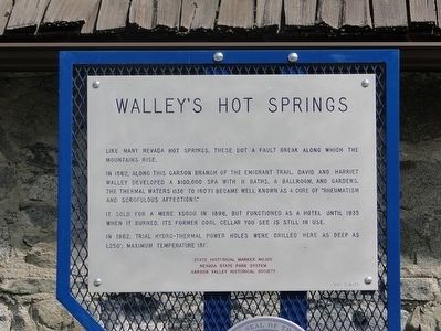
Like many Nevada hot springs, these dot a fault break along which the mountains rise. In 1862, along this Carson branch of the Emigrant Trail, David and Harriet Walley developed a $100,000 spa with 11 baths, a ballroom and gardens. The thermal . . . — — Map (db m89511) HM
On Esmeralda Avenue east of Fourth Street, on the right when traveling north.
Ground was broken for the garage in 1911, with structure additions in 1917 and 1927. The initials stand for the owner Clarence Oliver Dangberg. Later, under the ownership of the Fred "Brick" Hellwinkel family, the C.O.D. garage was the oldest . . . — — Map (db m23514) HM
On Esmeralda Avenue at Fifth Street when traveling north on Esmeralda Avenue.
Construction began in 1968 when the old Farmer's Bank, purchased in 1954 by the First National Bank of Nevada, had again outgrown itself. The remodeled building now houses an engineering firm owned and operated by R.O. Anderson. — — Map (db m23787) HM
This, the second house built in Minden (1907), housed Henry Beck, the first manager of the Minden Milling Company, and was located across the street from from the mill at Fifth Street and Railroad Avenue, now Highway 395. — — Map (db m23898) HM
On Esmeralda Avenue at 7th Street, on the right when traveling west on Esmeralda Avenue.
Built in 1917 for local rancher M.E. Fay, the home was later owned by John and Norma Ellis. John, Norma and their son Darwin owned and operated the Minden Mercantile. — — Map (db m23936) HM
On Esmeralda Avenue at Fourth Street, on the right when traveling north on Esmeralda Avenue.
First opened in 1910 by Chris Christoffersen. This was the first store in Minden of its type, selling dry goods, clothing, shoes, and cameras. Later, the store was operated by Lin Blondin and Ken Watson. In time, it became known as Town and Country . . . — — Map (db m23578) HM
Near U.S. 395 north of Buckeye Road when traveling south.
Completed in 1908, the new mill was financed by many of the early residents of Minden. Initially, it could process 100 barrels of flour daily from the local grain. Its four silos held 65,000 bushels of grain. In 1921 the mill was described as "one . . . — — Map (db m23981) HM
On Esmeralda Ave near Fourth Street, on the right when traveling north.
The original building was constructed in 1951 for the partnership of Warren Reed and Willard Meneley Insurance Company. In 1953 the offices also served as the temporary home for the Douglas County Public Library. Reed's son Alan and family currently . . . — — Map (db m23742) HM
On Esmeralda Avenue at Fourth Street, on the right when traveling north on Esmeralda Avenue.
The Second Farmer's Bank was constructed in 1918 and operated until 1968. The bank had sound financial resources for its size and in 1933, following a bank moratorium called by President Roosevelt, Farmer's Bank was among the first in the nation to . . . — — Map (db m23700) HM
On Esmeralda Avenue at 3rd Street, on the right when traveling west on Esmeralda Avenue.
Built in 1910, few buildings in Minden have experienced a more diverse life. Its many uses include a saloon/bar, card parlor, soda fountain, grocery store, and several restaurants. — — Map (db m23361) HM
During the late 1940s, this land was used by Sky Harbor Airport and Casino, which flew its wealthy patrons in from San Francisco to spend money in the local casinos. The airport consisted of a dirt landing strip, but with the snow-crested Crystal . . . — — Map (db m91859) HM
On Lake Tahoe Boulevard (U.S. 50), on the right when traveling east.
In commemoration of The Pony Express, a fleeting but exciting epoch in the winning of the West.
Erected April 4, 1963 by Harrah’s, William F. Harrah, President.
The first Pony Express rider passed here April 4, 1860 on his way to Friday’s . . . — — Map (db m46433) HM
Lumbering operations in the Glenbrook area of Lake Tahoe began in 1861. Consolidation of V-Flume systems in and near Clear Creek Canyon by 1872 made it possible to float lumber, cordwood, and sawed material from Spooner’s Summit to Carson City and . . . — — Map (db m21014) HM
On Railroad Street at 7th Street, on the right when traveling north on Railroad Street.
Elko was named county seat when Elko
County was formed March 5, 1869.
The creation of a new county, carved out
of neighboring counties, was necessary
to handle the fast-growing mining
communities in northeastern Nevada. A
brick courthouse was . . . — — Map (db m142660) HM
On Commercial Street at 7th Street on Commercial Street.
During the 1800's this site was used as a bivouack-camp area for the "Sagebrush Clippers." These wagons served the mining districts of the area almost exclusively. The name of this colorful area was derived from the Missouri Mule, a cousin of the . . . — — Map (db m105208) HM
On West Idaho Street (Nevada Route 535) near Hot Springs Road, on the right when traveling east.
Directly south of this point and across the valley floor are the remains of a short-lived extraction plant, which reached the peak of its productive capacity in the early twenties. Driving of the main shaft began in 1916. Of several tries at . . . — — Map (db m76742) HM
One of Elko's oldest saloons first opened in a tent in December of 1868 at this location. The building was completed in 1913 costing $50,000. The saloon featured tiled floors, metal ceiling, mahogany furniture and a mirrored back bar. With the upper . . . — — Map (db m89424) HM
On Idaho Street, 0.2 miles north of 14th Street, on the left when traveling north.
The Pony Express was the first attempt to have fast mail service to California. This was done through the personal drive and bravery of very young men who were responsible for bringing the mail and other “Deliverables” to the western . . . — — Map (db m146800) HM
Basque immigrant, Peter Juaregui had a dream to open a hotel and bar to provide his fellow countrymen with a familiar place to gather, share news of the old country and to live during the off season from their ranching jobs. On December . . . — — Map (db m89425) HM
On Main Street, on the right when traveling north.
The building was moved from Cornicopia Nevada to its present site in 1877. In 1881 it was purchased by Elizabeth Zweifel.
Through the years it has served as a rooming house, post office, telephone office, justice court, law office and school . . . — — Map (db m89477) HM
On Wendover Boulevard, 0.5 miles west of U.S. 93, in the median.
Wendover Will has been greeting travelers to Wendover since 1952. His name comes from the founder of the State Line Hotel & Casino, Mr. William “Bill” Smith, who started the State Line Service, a cobble stone service station, on the . . . — — Map (db m75211) HM
On Veterans Memorial Hwy (U.S. 95), on the right when traveling south.
The remnants of Columbus are located on the edge of the Columbus salt marsh, five miles to the southwest.
The town was initially settled in 1865, when a quartz mill was erected at the site. This was a favorable location for a mill, because . . . — — Map (db m240321) HM
On N 5th Ave at Maple St, on the left when traveling east on N 5th Ave.
An original headframe from the Combination Mine, on the Combination No. 1 claim, located by Alva D. Myers and R.C. Earl on May 26, 1903. In 1989 it was moved to this location from approximately 1/4 mile mile east, in the Goldfield Mining District, . . . — — Map (db m116165) HM
On Ramsey Street at Columbia Street, on the left when traveling east on Ramsey Street.
This building was the communications center of Goldfield from 1908 until 1963. The Consolidated Telephone – Telegraph Company Building was one of the few spared by a fire that destroyed 53 blocks of the downtown area in 1923. Today, this building . . . — — Map (db m234151) HM
Goldfield came to be, and nearly vanished back into the sagebrush of the desert, an almost a decade. From its humble beginnings in 1902 of only three small mining claims, also known as grubstakes, the town exploded and was the largest city in the . . . — — Map (db m116111) HM
On Crook Avenue (U.S. 95) north of Franklin Avenue, on the right when traveling north.
For a 20-year period prior to 1900 the mining in Nevada fell into a slump that cast the entire state into a bleak depression and caused the loss of a third of the population.
The picture brightened overnight following the spectacular strikes in . . . — — Map (db m42666) HM
On Nevada Route 266, 19 miles west of Nevada Highway 95, on the left when traveling west.
Known as a contact point for Shoshones and Northern Paiute Indians, Lida Valley was the site of early prospecting in the 1860's.
Later prospectors organized a mining district in 1867 and laid out the town in 1872. Soon stores, shops, stables . . . — — Map (db m52961) HM
On Nevada Route 266, 31 miles west of U.S. 95, on the right when traveling west.
Thinking that local Joshua trees were related to palm trees, the 1866 prospectors named the mining camp Palmetto. Although a local 12-stamp mill worked the silver ore, the town died for lack of profitable material. New discoveries in the late 1860's . . . — — Map (db m35150) HM
On Ramsey Street east of Columbia Avenus, on the right when traveling east. Reported permanently removed.
This was the communications center of Goldfield from 1906 until 1963. From 1904 to 1920, Goldfield boomed as a gold producing center. It was the largest (20,000+) city in Nevada during that period, having four railroads and other modern . . . — — Map (db m114228) HM
On 5th Avenue at Pearl Street, on the left when traveling north on 5th Avenue.
Built in 1905 by Hubert Maxgut, the Santa Fe Saloon is the oldest continually operating business in Goldfield. Maxgut was killed in a gunfight in 1912, but subsequent owners kept the saloon open. It was located outside of the business district to be . . . — — Map (db m65381) HM
On Veterans Memorial Hwy (U.S. 95) at 4th Street, on the right when traveling east on Veterans Memorial Hwy.
1908 - West Side Elementary School.
1910 - Manual training & domestic science classes.
1917-1920 - Goldfield School of Mines.
1931 - Was used by Novackclub Inc. as a golf club factory.
1945 - The building & adjacent land was . . . — — Map (db m115936) HM
On Veterans Memorial Hwy (U.S. 95), on the right when traveling west.
If you're looking for Grandpa you found him – about 26 miles south of Tonopah on US 95 – where you're standing right now.
Gran Pah, in Shoshone, means “great water,” and was the first name given to the mining district . . . — — Map (db m116115) HM
On Highway NV265, on the right when traveling south.
Updated Marker:
The Pittsburgh-Silver Peak Gold Mining Company bought the major mines in the area in 1906. Land speculators at nearby Silver Peak bought up the land. As a result, the mining company surveyed a new townsite north of Silver . . . — — Map (db m89417) HM
Near Interstate 80, 11.8 miles west of Nevada Route 306, on the right when traveling west.
The numerous valleys of Nevada have supported a vigorous cattle industry since the 1850's. Beginning in the western part of the state, cattlemen ranged their herds throughout northern Nevada by the 1870's. The completion of the transcontinental . . . — — Map (db m149718) HM
Near Interstate 80 at milepost 258, on the right when traveling east.
From this vantage point one can see the steam rising from the geysers located near the base of the far hill across the valley.
The U.S. Geological Survey has designated an area south of Beowawe a Known Geothermal Resource Area (KGRA). The . . . — — Map (db m240318) HM
On 6th Str at Ruby Way, on the right when traveling east on 6th Str.
Silver ore was discovered at Mount Tango in 1862 by a group of Mexican prospectors. They took the ore to Austin, Nevada. It was assayed. They were paid, and they were never heard from again.
In May of 1863 Simeon Wenban led a group to the Mount . . . — — Map (db m138451) HM
On Main Street (U.S. 50) at Ruby Hill Avenue on Main Street.
This historic five-hole outhouse was built for prominent Eureka businessman, Frederick Bartine (1888-1964).
A native of Finland, Bartine immigrated here in 1901. Soon after, he prospered as owner of the Ruby Hill Water Works, the Bartine . . . — — Map (db m51694) HM
On South Main Street, on the right when traveling north.
The opera house was constructed by Richard Ryland, Joseph Winzell, and M.D. Foley in October through December of 1880. They used the foundation of the Odd Fellows Hall. The building had been destroyed earlier in the year during a disastrous fire. . . . — — Map (db m69601) HM
On Monroe Street at Ruby Hill Avenue, on the left when traveling north on Monroe Street.
Constructed in 1879 at a cost of $10,000, the Sentinel Building was designed by architect C.M. Bennett. The Eureka Sentinel was published in this building from 1879 to 1960. Three generations of the Skillman family, Archibald, Edward and Willis, . . . — — Map (db m14686) HM
On Monroe Street at Ruby Hill Avenue, on the left when traveling north on Monroe Street.
When A. Skillman closed the Shermantown Reporter at Hamilton he moved is printing press to Eureka. Together with Dr. L.C. McKenny they started the Sentinel as a weekly paper in July 1870. It became a daily in June 1871 reporting local and . . . — — Map (db m14687) HM
On Highway 50 at Tan Hill Road, on the right when traveling east on Highway 50.
The Tannehill brothers built this cabin for a residence in 1864 and lived here about a year before selling their mining interest to a New York company in 1866. The cabin subsequently went through a number of owners, including the firm of Nathan & . . . — — Map (db m14688) HM
On Old Highway 40 (Nevada Route 789) at Guernsey Street, on the left when traveling east on Old Highway 40.
Golconda is a one time Utah Territory mining town whose hot springs, a landmark on the California Emigrant Trail, were of more enduring fame than its gold and silver boom.
In 1868, Golconda became an ore shipping station on the new Central . . . — — Map (db m67432) HM
Near Interstate 80 at milepost 187, on the right when traveling west.
A few houses, a ferry across the Humboldt River, and Bridge Street paved with sagebrush stubs comprised the town of Winnemucca in 1873 when Frank Button and his uncle I.V. Button drove cattle into the area to begin ranching operations in the rich, . . . — — Map (db m67427) HM
Austin, mother town of mining camps, sprang into being after William Talcott discovered silver at this spot on May 2, 1862. Talcott came from Jacobsville, a stage stop six miles to the west on the Reese River, the first Lander County seat. He was . . . — — Map (db m14435) HM
On Main Street, on the right when traveling north.
Built of lumber from the first International Hotel constructed in Virginia City.
David E. Buel built the hotel after being refused a free lot in Clifton at the mouth of the canyon below.
Buel, Frederick Baker, W.C. Harrington and John E. . . . — — Map (db m69613) HM
On Water Street at Reese Street, on the left when traveling east on Water Street.
This simple stone structure, opened to the public in late 1863, was originally operated as a general merchandise store by the firm of Gridley, Hobart and Jacobs. Gridley is best remembered for his 1864 wager which prompted the auctioning of a sack . . . — — Map (db m14612) HM
Started in the fall of 1896 and completed in June, 1897, by Ansom Phelps Stokes, mine developer, railroad magnate and member of a prominent eastern family, as a summer home for his sons, principally J.G. Phelps. After the castle (or the tower, as . . . — — Map (db m14436) HM
On U.S. 93 at milepost 8.5 at the dirt road to Delamar, on the right when traveling north on U.S. 93.
John and Olivia Ferguson discovered gold twelve miles south of here around 1891. The original name of the camp they established was Ferguson. However, it was eventually renamed "Delamar" after John DeLamar, an entrepreneur who bought the best . . . — — Map (db m193828) HM
On Nevada Route 318 at milepost 5, on the left when traveling north.
As early as 1865, a camp was established here and in the Spring of 1866, Colonel W.H. Raymond and others laid out the townsite. Hiko, situated in the Pahranagat range of mountains, is an Indian expression for "white man's town." Raymond, with . . . — — Map (db m1300) HM
On 5th Street at C Street, on the left when traveling north on 5th Street.
This steam engine powered a portable sawmill in the Clover Valley Mountains of Lincoln County. Brought to the West in the late 1860s by William and O.P. Sherwood of Pioche, the engine changed hands several times during its half century of operation. . . . — — Map (db m69473) HM
On Main Street at 4th Street, on the left when traveling east on Main Street.
This building, popularly known as the Panaca Co-op, was constructed of adobe in 1868, by the (Mormon) "Panaca Cooperative Mercantile Institution" comprising more than one hundred stock holders -- to meet barter, merchandising, and marketing needs. . . . — — Map (db m69470) HM
These beehive-shaped kilns were built in the mid-1870's to produce charcoal for the silver mills of Pioche and Bullionville, Nevada. Skilled stone masons quarried Rhyolitic tuff from nearby outcrops. The blocks were carefully dressed, then joined . . . — — Map (db m89432) HM
On Main Street (Business Route 93) at Nevada Route 322, on the right when traveling north on Main Street.
1864 - 65 this building survived the ravages of fire as well as gunfire.
Probably used at first as a social center, later to be used by interested citizens and businessmen.
Organized as "The Pioche Commercial Club," its purpose was to work . . . — — Map (db m46401) HM
On U.S. 93 at milepost 132, on the left when traveling north.
Local legend attributes the discovery to the locator picking up a rock to throw at a jackrabbit and finding himself holding high grade silver. The Jack Rabbit District, named for the mine, was located in 1876 by Isaac Newton Garrison. Early mine . . . — — Map (db m69484) HM
On Lacour Street north of Pioche Street, on the left when traveling north.
This hotel was built in 1895 by the Ely Valley Mines to house their guests. And lay claim to such overnight guests as Herbert Hoover, Nel Murbarger (Famous author of the "Old West") Many U.S. Senators and Nevada Governors and many other notables. . . . — — Map (db m89473) HM
On Extraterrestrial Highway (Nevada Route 375 at milepost 9), on the right.
In 1864 signs of silver and gold were found approximately 8 miles south of this location. About 1870 the Groom Mining District was organized. The Groom Mine operated until the mid 1870's thanks to English capital investment of about $80,000, but . . . — — Map (db m61007) HM
Born in Virginia in 1817, an often-inebriated prospector named James Finney was known as "Old Virginia" or "Old Virginny" to his friends. He lived in a tent dug into the side of the hill, which would become known as Johntown, located two miles from . . . — — Map (db m89525) HM
On Lincoln Highway (U.S. 50) south of 4th Avenue, on the right when traveling south.
The Carson River While camping in 1849, waiting for snow to melt in the Sierra Nevada, frontiersman and wagon train guide Abner Blackburn used a butcher knife to dig Nevada's first-found gold from a creek bed at the mouth of Gold Cañon. The . . . — — Map (db m160800) HM
On Cemetery Road/Main Street at Shady Lane on Cemetery Road/Main Street.
In July 1849, Abner Blackburn, a former member of the Mormon Battalion, made the first gold discovery in what is now Nevada near this site (see the canyon to the right). William Prouse, a member of a passing emigrant party, made a second discovery . . . — — Map (db m143642) HM
On Lincoln Highway (U.S. 50) at Segale Road, on the right when traveling west on Lincoln Highway.
Sutro was a town, a tunnel, and a man. The well-planned community was headquarters for the Sutro Drainage Tunnel.
German-born Adolph Sutro came to the Comstock in 1860. He advocated a drainage tunnel, visualizing development of Comstock ore . . . — — Map (db m175810) HM
Near Main Street at Shady Lane, on the left when traveling west.
Had its beginning in May, 1869, when Fred Birdsall built a half-mile horse drawn railroad from the Lyon Mill of Dayton to the Gold Canyon Mine Tailings. On July 11, 1881, Engine No. 1, the “Ernie Birdsall,” first ran on a 3 foot gauge . . . — — Map (db m160797) HM
On Main Street just west of Lincoln Highway (U.S. 50), on the right when traveling west.
The Carson and Colorado Railroad (C&C) The Carson and Colorado Railroad (C&C), completed in 1881, operated on a 3-foot narrow-gauge track. Nicknamed the "Slim Princess," it provided transportation from Mound House, Nevada to Keeler, California . . . — — Map (db m160798) HM
On Main Street at Pike Street, on the left when traveling west on Main Street.
The original Union Hotel was located across the street. It was rebuilt here in 1870 after a fire destroyed the old hotel. The former post office site originally housed the dining room and barber shop. The freestanding rock wall is the original . . . — — Map (db m89513) HM
On Main Street just west of Lincoln Highway (U.S. 50), on the right when traveling west.
Dayton (known as Chinatown 1857-1861) Dayton is the site of Nevada's first gold discovery (1849) and the state's first permanent Euro-American settlement, founded after miners created a tent town at the mouth of Gold Cañon in 1851. Initially . . . — — Map (db m160799) HM
On Main Street (Nevada Route 342) near Roses Road, on the left when traveling north.
Two well-educated brothers, Hosea and Ethan Grosh, discovered silver here in 1856 but both died in 1857 before their ore was assayed. Had they lived they might have gone on to locate the Comstock Lode. Their cabin was ¼ - mile to the South. — — Map (db m174102) HM
Samuel S. Buckland was a true pioneer. He settled here in 1859, began a ranching operation, established a station for the Overland Stage Company, and operated a tent hotel. He also constructed the first bridge across the Carson River downstream . . . — — Map (db m61066) HM
On Ruta Estatal de Nevada/Wellington Cutoff (Nevada Route 829), on the right when traveling east.
Established by Zodak Pierce in 1875 as a hotel, grocery and feed store. It was sold in 1903 to the Reading Bros., of Bodie, who renamed it the W.E. Reading General Merchandise. Later on in 1945, Perry and Gerri Aikens acquired it and gave it its . . . — — Map (db m169796) HM
Edward P. Lovejoy was the son of Elijah Lovejoy, "the first American martyr to the freedom of the press and freedom of the slave". As a young man, Edward left the midwest for California where he served as district attorney, judge, and newspaper . . . — — Map (db m229659) HM
On Alternate U.S. 95, on the left when traveling north.
Built in 1881 by Edward P. Lovejoy, this building has served as a general merchandise & produce, hotel, restaurant, bar, grocery and post office.
After a succession of owners, Mitch first aquired the property in 1994 to operate a bar. His . . . — — Map (db m229578) HM
On Nevada Route 208 near Hoye Canyon Road, on the left when traveling south.
Early pioneers John and Mary Hoye came to the valley in 1863 or 1864. On the edge of Alkali Flat they operated a station which they later move to its present location in 1873.
Through the years there have been several owners without any . . . — — Map (db m169820) HM
On N Main Street, on the right when traveling south.
Built in 1893 by Dr. Granville I. Leavitt, a local doctor and Indian reservation doctor. The upstairs was used as the Masonic Lodge meeting hall; downstairs was the Kash & Karry Unified Grocery until the late 1950’s. The hall was used by Hope Lodge . . . — — Map (db m138026) HM
In 1858 Henry Miller, known as the Cattle King of California, and Charles Lux, a fellow German with a keen business sense, formed one of the most successful partnerships in American history. The Miller & Lux Firm began buying up land and cattle . . . — — Map (db m116877) HM
On Nevada Route 208 just north of Copperbelt Drive.
Wilson Canyon and the Wilson Mining District were named for brothers David and “Uncle Billy” Wilson. David Wilson (born 1829) came west in 1850 during the California Gold Rush. He returned to the Midwest in 1853, married, and joined the . . . — — Map (db m143611) HM
Near NF-45 north of NF-190, on the right when traveling north.
The history of the Nine Mile Ranch has a long and interesting past, beginning with the Paiute Indians who inhabited this area long before John C. Fremont’s expedition into Nevada in 1843-1844. According to Fremont’s journal he camped in this area . . . — — Map (db m191201) HM
On U.S. 95A at Freedom Road (Nevada Route 362), on the right when traveling south on U.S. 95A.
Debuted in the later forties at the Hawthorne Club located at the corner of 5th and E Street, the main intersection of all roads entering Hawthorne. This was a sign of the times with neon lighting. It brightened the intersection with its huge . . . — — Map (db m61068) HM
On Silver Street at 4th Avenue, on the right when traveling east on Silver Street.
Born July 1840 in Nicaragua. Died February 1, 1915 in Luning, Nevada. Mother of Conchetta, Conception, Juanita, Emma, James A. Marshall, Frank and Frederick Mason.
Ferminia Sarras was born in Nicaragua and immigrated to America in 1867. . . . — — Map (db m189611) HM
Founded in 1873, Belleville flourished by milling the ore from the Northern Belle Mine in Candelaria. The mill located just east of here made its first bullion bar shipment ($9,200) in April, 1875.
Belleville was famous for murders, drunken . . . — — Map (db m89420) HM
On Candelaria Road at Veterans Memorial Highway (U.S. 95), on the right when traveling west on Candelaria Road.
Seven miles to the west lie the ghost towns of Candelaria and Metallic City.
Candelaria was presumably named after a mine of that name located in 1885, and also after the Catholic Candelmas Day. Metallic City, the "sin city" of Candelaria, and . . . — — Map (db m42342) HM
On U.S. 95 north of County Route 360, on the right when traveling north.
Salt pools discovered and developed here in 1862, led to a thriving business by delivering salt to mining mills in Virginia City by camel. Up until this time, the salt was purchased from San Francisco at a rate between 120 & 180 dollars a ton. Sales . . . — — Map (db m89451) HM
On State Road 373, 7.5 miles north of Death Valley Junction, on the left when traveling north.
Near here is the site of the Bradford Siding on the Death Valley Railroad spur of the Tonopah and Tidewater Railroad. This siding was used by the extensive clay quarries active in the Amargosa Valley from the 1920's until 1940. The first clay claim . . . — — Map (db m107073) HM
On Main Street east of Irving Street, on the right when traveling east.
The Fordson tractor by the Ford Motor Company was the first
agricultural tractor to be mass-produced. It was a lightweight,
frameless tractor with a vapouriser-fed engine and four metal
wheels. Henry Ford was raised as a farmer and yearned . . . — — Map (db m195540) HM
Beatty was the center of three short-lived, so-called "gold" railroads that were spawned by the strikes of the early 1900's in Tonopah, Goldfield and Rhyolite.
During 1906-'07 three railroads were built in this area. The Las Vegas and . . . — — Map (db m31924) HM
Near Cedar Street, 0.1 miles west of Main Street (Nevada Route 82), on the left when traveling west. Reported missing.
Once visited by prehistoric man, Shoshone Indians also used this site for jackrabbit drives and for celebrations.
Silver ore discoveries in 1865, the convenience of wood and water and a naturally fine location resulted in the attractive . . . — — Map (db m86419) HM
Near Berlin Ichthyosaur State Park Road, 2 miles south of Route 844, on the left when traveling east.
Thousands of sacks of charcoal were stacked in this area. The charcoal was used to fire the furnace used to assay the ore samples at the nearby assay office, and as fuel for blacksmith forges in the machine shop at the mine. Because charcoal is . . . — — Map (db m89588) HM
Near Berlin Ichthyosaur State Park Road, 2 miles south of Route 844, on the left when traveling south.
The Company-owned boardinghouse that stood here was leased and run by (China) Tom Joe at the turn of the century. From here, China Joe moved to Ione to operate a boardinghouse of his own. From 1905 until the mine and mill shut down in 1907, the . . . — — Map (db m89589) HM
On Berlin Ichthyosaur State Park Road, 2 miles south of Nevada Route 844, on the right when traveling south.
The Company Store stood on this lot. It sold nearly everything needed in everyday living, including clothing, groceries, prospecting supplies, grain, and drugs. The local doctor acted as his own druggist by compounding the drugs he prescribed . . . — — Map (db m240319) HM
Near Berlin Ichthyosaur State Park Road, 2 miles south of Route 844, on the right when traveling south.
Because the area was sparsely settled and his patients were few, Dr. Bruton was a poor man. He walked when he visited the sick in Berlin and Union Canyon, carrying his satchel which contained all the instruments and medicines he might need. If . . . — — Map (db m89594) HM
Near Berlin Ichthyosaur State Park Road, 2 miles south of Nevada Route 844, on the right when traveling east.
Bill and Mack Foster moved this building to here from Ellsworth. It was used as a blacksmith shop by them when they were prospecting in this area for about twenty years preceding the year 1954. — — Map (db m89579) HM
Near Berlin Ichthyosaur State Park Road, 2 miles south of Nevada Route 844, on the left when traveling south.
This building contained the blacksmith shop, and was equipped with power driven drill presses, and lathes, etc. Therefore, it was called the machine shop. The crew of mechanics that worked here kept all the mine and mill machinery running . . . — — Map (db m89580) HM
Near Berlin Ichthyosaur State Park Road, 2 miles south of Route 844, on the left when traveling east.
Mr. Bowen, the mine superintendent, believed in dealing with his fellow men with justice and understanding, but he could not be deterred from administering his duties for the company conscientiously.
In 1907, when the miners struck for a raise . . . — — Map (db m89585) HM
Near Berlin Ichthyosaur State Park Road, 2 miles Route 844, on the left when traveling south.
This building was a beehive of activity while Berlin was in its heyday.
One man tended to the primary crusher and did other odd jobs, another tended the 30 stamps and the concentration tables, and a third man fired the five boilers and looked . . . — — Map (db m89583) HM
Near Berlin Ichthyosaur State Park Road, 2 miles Nevada Route 844, on the left when traveling east.
The Two-Story building that stood here was called the "Clubhouse". It might have been erected to house the mine and mill office, but during the years from 1906 to 1908, it was used as quarters for visiting company officials and local supervisors . . . — — Map (db m89587) HM
Near Berlin Ichthyosaur State Park Road, 2 miles Route 844, on the right when traveling east.
W.J. Watson who was a postmaster and store manager lived in this house with his daughter, Mrs. Reston and his granddaughter Zoe.
Although Mr. Watson was an employee of high rank, and he was aware of the anti-liquor policy of the company, he . . . — — Map (db m89584) HM
On Highway 376 at NF-017 (Dirt Road), on the left when traveling north on Highway 376.
Well up into the canyon out yonder, one can still see the massive stone foundations of a costly and splendid stamp mill, as well as, the stone walls of an elegant office and mansion. Here was the scene of once busy place, now a ghost town. Ore was . . . — — Map (db m89408) HM
On Highway 376 at Highway 377, on the left when traveling north on Highway 376.
The Manhattan Mining Camp northeast of here, was first organized in 1867. The place name persisted in local use, and was adopted in 1905 when John Humphrey found gold at the foot of April Fool Hill near the old stage route. A typical boom . . . — — Map (db m89409) HM
Near Rhyolite Road, 1.4 miles north of Nevada Route 374, on the right when traveling north.
Gold was discovered in this area in 1904. Several
mining camps quickly grew around the
discoveries. The town of Rhyolite was founded
in 1905 and became the city of dreams; dreams
of gold, prosperity, greed, and speculation.
By 1906 . . . — — Map (db m159246) HM