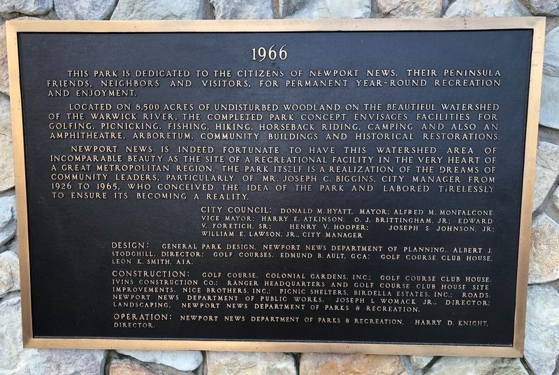
On Constitution Way 0.4 miles east of Jefferson Avenue (Virginia Route 143) when traveling west.
In recognition of the 50th Anniversary of
Newport News Park
1966 - 2016
"On the occasion of its 50th anniversary, this park, one of the largest and most treasured municipal parks in the country, is hereby rededicated for the enjoyment of . . . — — Map (db m165307) HM
Near Brooke Avenue at Harbour Street, on the left when traveling west.
At 0100 hours on October 1, 1972, the USS Newport News was firing a support mission off the coast of South Vietnam. An 8 inch projectile jammed in the center gun of Turret Two. The subsequent implosion and fire killed 20 crewmembers and injured 36 . . . — — Map (db m48342) HM
On West Avenue at 27th Street, on the left when traveling north on West Avenue.
This area was blessed with abundant springs famous to mariners for centuries after the great sea captain Christopher Newport visited here enroute to Jamestown in May 1607 in command of the first permanent English settlers of the New World. Thus . . . — — Map (db m16568) HM
Near Washington Avenue at 41st Street, on the right when traveling west.
The 90-foot tugboat Dorothy, Hull Number One, was delivered by Newport News Shipbuilding in 1891. As Dorothy plied her trade over the next 73 years, her reputation for dependability became a maritime legend. The little tugboat was recognized . . . — — Map (db m34029) HM
Near Jefferson Avenue (Virginia Route 143) at Constitution Way, on the right when traveling west.
This area was first referred to as "Newportes Newes" as early as 1619, and the first known English settler lived here in 1621. Several Civil War engagements took place here including the Battle of the Ironclads and the 1862 Peninsula Campaign. . . . — — Map (db m193633) HM
On 25th Street near Washington Avenue, on the left when traveling south.
This area was first referred to as "Newportes Newes" as early as 1619, and the first known English settler lived here in 1621. Several Civil War engagements took place here including the Battle of the Ironclads and the 1862 Peninsula Campaign. . . . — — Map (db m33962) HM
Near Washington Avenue at 35th Street, on the left when traveling west.
Launched by Newport News Shipbuilding during its centennial year – 1986 - as attribute to the company and city in which it stands, USS Newport News is the 17th Los Angeles-class submarine built by the Shipyard, the lead yard for the . . . — — Map (db m34021) HM
On Parish Avenue, on the left when traveling north.
The monument that stands before you was erected in June 1900 by the members of the Magruder Camp No. 36, United Confederate Veterans, to honor the 163 Confederate soldiers reinterred at this site who had died in the POW Camp next to Camp Butler on . . . — — Map (db m10446) HM
Near West Avenue north of 26th Street, on the left when traveling north. Reported missing.
Newport News was a small community located in Warwick County until late in the 19th century. Established as a town in 1880, it was incorporated as a city in 1896. Warwick County, one of the eight original Virginia shires formed by 1634, . . . — — Map (db m293501) HM
On 32nd Street at Huntington Avenue (U.S. 60), on the right when traveling east on 32nd Street.
The city's first dedicated white public high school building, a three-story edifice of 20 classrooms, opened on this site in September 1899 as the Central School. The level of instruction quickly expanded to include both primary and secondary . . . — — Map (db m293497) HM
On Martin L. King Jr. Way at Jefferson Avenue on Martin L. King Jr. Way.
The report of Dr. King’s death by an assassin’s bullet on April 4, 1968, left the nation and the world stunned. The shock was especially pronounced because the minister had advocated nonviolence throughout his civil rights career. A victim of the . . . — — Map (db m98326) HM
On Martin L. King Jr. Way at Jefferson Avenue on Martin L. King Jr. Way.
As part of Dr. King’s crusading efforts, he made appearances at historically black colleges throughout the country, including Hampton Institute, to spread his message. As a man of the cloth, his most frequent venue for reaching African Americans . . . — — Map (db m98321) HM
On 25th Street at Washington Avenue, on the right when traveling north on 25th Street.
Jessie Menifield Rattley (1929-2001) was born in Birmingham, Alabama. She moved to the Virginia Peninsula to attend Hampton Institute. After graduating with honors in 1951, Mrs. Rattley established the first business department at Huntington High . . . — — Map (db m33964) HM
On Richneck Road 0.1 miles south of Jefferson Avenue ( Route 143), on the right when traveling south.
Newport News was a small community located in Warwick County until late in the 19th century. Established as a town in 1880, it was incorporated as a city in 1896. Warwick County, one of the eight original Virginia shires formed by 1634, . . . — — Map (db m165302) HM
Near Yorktown Road (Virginia Route 238) south of Lebanon Church Road, on the right when traveling north.
Newport News was a small community located in Warwick County until late in the 19th century. Established as a town in 1850, it was incorporated as a city in 1896. Warwick County, one of the eight original Virginia shires formed by 1634, became . . . — — Map (db m293513) HM
On 41st Street at Washington Avenue, on the right when traveling east on 41st Street.
Presented to Newport News Shipbuilding
On the occasion of the launching of the attack submarine Newport News (SSN-750)
By the City of Newport News
In recognition of the company's extraordinary contributions over the past century to the civic, . . . — — Map (db m293498) HM
On Manor Place at Blacksmythe Lane, on the left when traveling east on Manor Place.
This foundation is the site of ‘Mathews Manor' (c. 1626) home of Samuel Mathews, Sr. (c. 1590 - 1659?). Col. Mathews served as a member of Va. Council of State, Va.'s agent to England during the Protectorate, and helped to settle the boundary . . . — — Map (db m251219) HM
On 16th Street (Virginia Route 167), on the left when traveling west.
Preface: Newport News was a small community located in Warwick County until late in the 19th century. Established as a town in 1880, it was incorporated as a city in 1896. Warwick County, one of the eight original Virginia shires formed by . . . — — Map (db m13945) HM
On Old Courthouse Way, on the left when traveling north.
By tradition, early Warwick County court sessions were held under a large elm tree at nearby Richneck Plantation, home of Col. Miles Cary, Jr. In 1810, Warwick’s first brick courthouse was built on this Denbigh site. It also served as clerk’s office . . . — — Map (db m11274) HM
On Washington Avenue at 41st Street, on the right when traveling west on Washington Avenue.
The first vessel constructed by Newport News Shipbuilding and Dry Dock Company was delivered in April, 1891. The 90-foot iron tugboat was designed by Horace See and built near present-day Dry Dock 2.
Named for the daughter of former Secretary . . . — — Map (db m34028) HM
Near Warwick Boulevard (U.S. 60), on the right when traveling north.
Preface: Newport News was a small community located in Warwick County until late in the 19th century. Established as a town in 1880, it was incorporated as a city in 1896. Warwick County, one of the eight original Virginia shires formed by . . . — — Map (db m13952) HM
Near Enterprise Drive 0.4 miles west of Warwick Boulevard, on the left when traveling west.
(preface) Newport News was a small community located in Warwick County until late in the 19th century. Established as a town in 1880, it was incorporated as a city in 1896. Warwick County, one of the eight original Virginia shires . . . — — Map (db m196108) HM
Near Enterprise Drive 0.4 miles west of Warwick Boulevard (U.S. 60), on the left when traveling west.
(preface) Newport News was a small community located in Warwick County until late in the 19th century. Established as a town in 1880, it was incorporated as a city in 1896. Warwick County, one of the eight original Virginia shires . . . — — Map (db m196078) HM
Near Atlantic Avenue just south of 14th Street, on the right when traveling south.
The First Lady of Jazz possessed superlative musicianship and skill in scat singing (improvisational vocals). After being discovered at age 16 in a Harlem talent show, Fitzgerald performed throughout America, Europe and Asia and on milestone . . . — — Map (db m165911) HM
Near Atlantic Avenue just south of 14th Street, on the right when traveling south.
President Nixon dubbed her "Ambassador of Love" to the world. "Pearlie Mae" sang with Count Basie and Cab Calloway, starred in the movie version of "Porgy and Bess," won a Tony Award for an African-American version of "Hello Dolly," and received the . . . — — Map (db m165915) HM
Near Pacific Avenue (U.S. 60) just south of 14th Street, on the right when traveling north.
Styron won the Pulitzer Prize for Literature as well as the William Dean Howells Medal from the American Academy of Arts and Letters in 1968 as a result of “The Confessions of Nat Turner.” He also wrote Sophie's Choice and won the . . . — — Map (db m165939) HM
Gregory Cherry was a man whose love for Newport News and the Southeast Community expressed itself in many ways. He served in the United States Army as an NCO Congressional Escort and in the prestigious Old Guard Fife and Drum Corps. He returned to . . . — — Map (db m98281) HM
On James River Drive at Villa Road, on the left when traveling east on James River Drive.
During World War I, electric streetcar service was extended by the Newport News and Hampton Railway Gas and Electric Company to the newly built community of Hilton Village in
the countryside of Warwick County. The first run to Hilton was on . . . — — Map (db m203467) HM
On Huntington Avenue (U.S. 60) at 64th Street, on the right when traveling south on Huntington Avenue.
Near this site on July 1, 1958, Mrs. Philip W. Hiden and Mrs. Homer L. Ferguson, assisted by Shipyard Board Chairman J. B. Woodward, Jr., cut the ribbon marking the consolidation of the cities of Warwick and Newport News into the greater city of . . . — — Map (db m110254) HM
Near Museum Drive 0.2 miles north of Museum Parkway, on the left when traveling south.
"The tree that built Tidewater"
Also known as longstraw pine, Southern yellow pine, Georgia pine
About the Longleaf
The longleaf pine tree is one of only nine native species of pine found in Virginia. Historically, it was found . . . — — Map (db m297275) HM
On Huntington Avenue (U.S. 60) 0.1 miles east of Benton Way, on the left when traveling south.
The first expansion to the city of Newport News was the North End, extending from the James River to Warwick (formerly Virginia Avenue) form 50th to 58th Streets in 1900. In 1920, the city boundary was extended to 64th Street. Immediately north of . . . — — Map (db m308122) HM
On Warwick Boulevard (U.S. 60) at 68th Street, on the left when traveling north on Warwick Boulevard.
Camps Hill and Alexander were created when Newport News was designated a port of embarkation by the U.S. Army after the United States entered World War I in 1917. Camp Hill was established in Aug. 1917 and named for Confederate Lt. Gen. A.P. Hill. . . . — — Map (db m308091) HM
On Elmhurst Street 0.1 miles south of Yorktown Road ( Route 238), on the right when traveling south.
The historic Lee Hall Depot was constructed in the 1880s as part of the Chesapeake and Ohio Railway’s efforts to establish its Atlantic terminus at Newport News, thereby linking the Ohio River Valley with the sea. The station was sited on Warwick . . . — — Map (db m34000) HM
On 27th Street (Virginia Route 143 E) at Jefferson Avenue, on the left when traveling east on 27th Street.
James A. Fields acquired this late-Victorian Italianate-style brick house in 1893. Fields, born into slavery in Hanover County, escaped in 1862 and became a contraband of war. He graduated in 1871 from what is now Hampton University and taught . . . — — Map (db m10607) HM
On West Avenue at 25th Street, on the right when traveling east on West Avenue.
"Greetings with love to those who return
A triumph with tears to those who sleep"
Newport News' Victory Arch provides a continuing memorial to American servicemen and women. Grateful Peninsula citizens built a temporary Arch, . . . — — Map (db m33954) HM
Near White Oak Trail at Dam #1 Bridge, on the left when traveling east.
The Battle of Dam No. 1 proved a lost opportunity for the Union Army to break the Warwick-Yorktown line and force a Confederate withdrawal toward Richmond. Instead, Major General George McClellan spent another 17 days completing his heavy . . . — — Map (db m277225) HM
Near Constitution Way east of Dam #1 Bridge, on the left when traveling east.
From this rifle pit, Colonel Hiram Berdan’s 1st U.S. Sharpshooters targeted Confederate troops on the opposite bank of the Warwick River. Hiram Berdan, considered the nation’s best marksman, organized the regiment from hand-picked volunteers who . . . — — Map (db m277217) HM
Near Constitution Way, on the right when traveling east.
George Armstrong Custer had the dubious honor of graduating last in the 1861 class at West Point. He was commissioned a second lieutenant in the 5th U.S. Cavalry and fought with the Army of the Potomac in almost every major battle from Bull Run . . . — — Map (db m277215) HM
Near Rivers Ridge Circle, on the left when traveling west.
The Battle of Lee’s Mill set the stage for an elaborate ruse as Gen. Magruder maneuvered his troops along the 12-mile line and created the illusion of double his numbers. Moreover, Gen. McClellan was daunted by the Confederate defenses and had . . . — — Map (db m11330) HM
Near Long Meadow Trail at Twin Forts Loop, on the left when traveling east.
The Vermont troops waited in vain for reinforcements; Corporal Alonzo Hutchinson was mortally wounded while crossing the Warwick River and died without signaling for support. The Union leaders also failed to exploit the break in the Confederate . . . — — Map (db m277223) HM
On Twin Forts Loop east of Long Meadow Trail, on the left when traveling east.
After the 15th North Carolina’s repulse, Brigadier General Howell Cobb (a former governor of Georgia and secretary of treasury) rallied the Confederates and prepared to drive the Vermonters into the water. Cobb commanded a brigade in Brigadier . . . — — Map (db m277224) HM
Near Twin Forts Loop east of Long Meadow Trail, on the left when traveling east.
Brigadier General William Smith massed 18 cannons in an open field within 500 yards of the opposite shore. In addition, General Smith deployed Brigadier General William T.H. Brooks’s Vermont Brigade along the Warwick River with two brigades in . . . — — Map (db m277222) HM
On Constitution Way just east of the Discovery Center, on the left when traveling east.
You are presently standing at the site of Dam No. 1, one of three dams constructed by Confederate commander John Bankhead Magruder to make the sluggish Warwick River into a defensive barrier. Dam No. 1 was the mid-point between two prewar tide . . . — — Map (db m180517) HM
On Constitution Way, on the left when traveling east.
A stalwart defense of the Warwick River by units of the 15th North Carolina, 7th Georgia and 2nd Louisiana Infantry, C.S.A., commanded by General J.B. Magruder is commemorated here. The defensive line extending across the Virginia Peninsula was held . . . — — Map (db m10340) HM
On Campsite Drive at Jefferson Avenue ( Route 143), on the right when traveling north on Campsite Drive.
U.S. Military Academy graduate, 1830, Virginia-born 'Prince John' Magruder served with distinction in the Mexican War. In 1861 he resigned as Colonel, USA and joined the Confederacy. In the Civil War's first planned battle, his forces were . . . — — Map (db m33996) HM
Near Constitution Way, on the right when traveling east.
On April 4, 1862, Major General George B. McClellan launched his offensive on the Virginia Peninsula against the Confederate capital at Richmond. Major General John B. Magruder’s 13,000 troops halted the Union advance along the Warwick-Yorktown line . . . — — Map (db m11254) HM
Near Twin Forts Loop at White Oak Trail, on the left when traveling east.
The twelve miles of Confederate defenses followed the course of the Warwick River one mile from Yorktown to Mulberry Island. Dam No. 1, the mid-point, was protected by this one-gun battery mounting a 12-pound howitzer. In addition, a 6-pound . . . — — Map (db m277220) HM
On Clubhouse Way at Dam #1 Bridge, on the right when traveling east on Clubhouse Way.
Following the 10 June 1861 Battle of Big Bethel, Maj. Gen. John B. Magruder, commander of the Confederate Army of the Peninsula, organized the construction of three defensive lines of fortifications across the peninsula. The main line extended 12 . . . — — Map (db m277219) HM
On Jefferson Avenue 0.3 miles south of 6th Street, on the left when traveling south.
Aviation pioneer Glenn H. Curtiss sponsored the Atlantic Coast Aeronautical Station on a 20-acre tract east of Newport News Boat Harbor in the fall of 1915 with Capt. Thomas Scott Baldwin as head. Many civilian students, including Canadians, later . . . — — Map (db m33952) HM
Near Washington Avenue at 35th Street, on the left when traveling west.
When Newport News Shipbuilding launched USS Nimitz in 1972, it was the world’s largest fighting vessel. In 1995 the Shipyard delivered USS John C. Stennis, the seventh in the class and Newport News Shipbuilder’s 27th aircraft carrier. — — Map (db m34026) HM
Near S. Liberty Street continued, on the left when traveling south.
Carl Vinson, native son, farmer, lawyer, statesman, served in the United States Congress for 50 years;
Chairman of the Naval Affairs Committee; Chairman of the Armed Services Committee;
an advocate for Military Preparedness; He was credited with . . . — — Map (db m42626) HM
On Chesapeake Avenue (Virginia Route 167) at East Avenue, on the left when traveling west on Chesapeake Avenue. Reported permanently removed.
In Hampton Roads, southward and a mile or two offshore, the Virginia (Merrimac) and the Monitor fought their engagement, March 9, 1862. The day before the Virginia destroyed the Cumberland and Congress, wooden ships of Union Navy. — — Map (db m10139) HM
On Deer Park Drive just west of Jefferson Avenue (U.S. 17), on the right when traveling west.
This 100-acre tract, then in Warwick County, was acquired in 1930 for the Mariners Museum by Archer Huntington. Encompassing the upper reaches of Lake Maury, it was used as a state game sanctuary for Virginia whitetail deer and other wildlife from . . . — — Map (db m167539) HM
On Warwick Boulevard (U.S. 60) at Franklin Road, on the right when traveling south on Warwick Boulevard. Reported missing.
Camp Alexander was created from a portion of Camp Hill between Warwick and Jefferson Avenues on Aug. 15, 1918. Part of the Hampton Roads Port of Embarkation, it quartered Black stevedore regiments and labor battalions. Named for 2nd Lt. John Hawks . . . — — Map (db m266824) HM
Newport News was a small community located in Warwick County until late in the 19th century. Established as a town in 1880, it was incorporated as a city in 1896. Warwick County, one of the eight original Virginia shires formed by 1634, became . . . — — Map (db m92325) HM
On Manor Place at Blacksmythe Lane, on the left when traveling east on Manor Place. Reported damaged.
Newport News was a small community located in Warwick County until late in the 19th century. Established as a town in 1880, it was incorporated as a city in 1886.
Warwick County and the eight original Virginia shires formed by 1634, . . . — — Map (db m251264) HM
On Bland Boulevard 0.2 miles east of Patrick Henry Drive, on the left when traveling north.
Named for Virginia Patriot-Orator Patrick Henry (1736-1799), an Army base of 1700 acres of Peninsula Woodland became a World War II staging area of 35,000 personnel capacity with shuttle rail service to ship-side. A key component of the vital . . . — — Map (db m269403) HM
On Beechmont Drive 0.1 miles west of Colleen Drive, on the right when traveling west.
Bolthorpe Plantation was located nearby on the Warwick River. The 1350 acre estate, originally owned by Captain Samuel Stephens, was sold to Colonel William Cole in 1671. As a loyalist, Cole supported the crown during Bacon's Rebellion. Cole . . . — — Map (db m266822) HM
On Wickham Avenue at 24th Street, on the right when traveling north on Wickham Avenue.
Ella Fitzgerald was born in Newport News on April 25, 1917. She later moved to New York where her singing talent was discovered at the legendary Apollo Theater in Harlem. Ella was the most popular singer in the world for more than half a century, . . . — — Map (db m167538) HM
Near Riverpark Road at Biggins Circle, on the left when traveling north.
Formed in 1924 when Huntington Park was established. This lake was popularly known as Lake Biggins by action of the Newport News City Council May 14, 1979. The lake became officially named to honor this dedicated public servant.
Joseph Charles . . . — — Map (db m98382) HM
Near Washington Avenue at 35th Street, on the left when traveling west.
Launched in 1890, the tugboat Dorothy was the first ship built by Newport News Shipbuilding. After a long career, Dorothy was brought home and refurbished in 1976 to stand on the Shipyard grounds as a tribute to the company’s . . . — — Map (db m34024) HM
Near Biggins Circle 0.1 miles west of Hornet Circle.
To provide emergency accommodation for shipbuilders on the eve of World War II, the U. S. Navy set up a 5,000 person housing development in 1940 on 68 acres between Warwick Road and James River. The first tenants moved into 100 prefab buildings in . . . — — Map (db m33968) HM
On Hornet Circle 0.1 miles south of Warwick Boulevard (U.S. 60), on the right when traveling south.
To provide emergency accommodation for shipbuilders on the eve of World War II, the U. S. Navy set up a 5,000 person housing development in 1940 on 68 acres between Warwick Road and James River. The first tenants moved into 100 prefab buildings in . . . — — Map (db m33969) HM
On West Avenue at 25th Street, on the left when traveling west on West Avenue.
The splendid natural harbor of Hampton Roads served the nation as a military port of embarkation in the Spanish American War and two World Wars. In World War 1, headquarters were set up at Newport News on July 11, 1917, and vast shipments of troops . . . — — Map (db m33953) HM
In 1906 this house became the home of J. Thomas Newsome (1872-1942) and his wife Mary. A lawyer, churchman and newspaper editor, Newsome was an early advocate for Huntington High School and also formed the Colored Voters League of Warwick County. He . . . — — Map (db m98334) HM
Near Washington Avenue at 35th Street, on the left when traveling west.
The most famous of all Newport News-built ships, the passenger liner SS United States still holds the world’s speed record for transatlantic crossings. The liner was launched in 1951 and delivered to the United States Line Company the . . . — — Map (db m34025) HM
Near Washington Avenue at 35th Street, on the left when traveling west.
A state holiday was declared on the day the 15,000-ton battleship USS Virginia was launched in 1904. USS Virginia was one of the seven battleships built by Newport News to sail in President Theodore Roosevelt’s Great White Fleet on its world . . . — — Map (db m34022) HM
On Harpersville Road at Gatewood Road, on the left when traveling east on Harpersville Road.
A station named for Col. J. S. Morrison, Construction Engineer of the Peninsula Division, Chesapeake & Ohio Railway, was built in the Warwick County Hamlet of Gum Grove on completion of the line between Richmond and Newport News on Oct. 16, 1881. . . . — — Map (db m77586) HM
On Middlebrook Avenue (Virginia Route 252) just west of South New Street, on the left when traveling south.
The Virginia Central Railroad extended westward from
Charlottesville to Staunton and on to Clifton Forge by 1854.
Also in the 1850s, the Covington & Ohio Railroad was under
construction to connect the railroad system to the Ohio River.
The Civil . . . — — Map (db m89502) HM
On Old Courthouse Way at Courthouse Drive, on the left when traveling north on Old Courthouse Way.
The Lost Cause
Like many courthouse greens, Warwick's once included a Civil War veterans memorial. It was erected during a time when southern society put up monuments to commemorate the Lost Cause. The granite shaft with a statue of a . . . — — Map (db m185121) HM
Near Old Courthouse Way at Grissom Way, on the left when traveling north.
The 1810 Courthouse
This structure, the oldest government building in the city, served as the second county courthouse from 1810-1884. The first, built in 1680, was on the Warwick River. In 1807 petitioners asked the legislature to . . . — — Map (db m185149) HM
On Riverview Parkway at Old Menchville Road, on the left when traveling west on Riverview Parkway.
(Center Panel)Warwick Town
Riverview Farm Park, built on the site of the former Warwick Town, is home to the Fantasy Farm Playground, a 30,000 square foot community playground. The park also includes soccer fields, . . . — — Map (db m253279) HM
On Old Grist Mill Lane at Warwick Boulevard (U.S. 60), on the right when traveling west on Old Grist Mill Lane. Reported damaged.
Newport News was a small community located in Warwick County until late in the 19th century. Established as a town in 1880, it was incorporated as a city in 1896. Warwick County, one of the eight original Virginia shires formed by 1634, . . . — — Map (db m293504) HM
On Potter's Lane at Warwick Boulevard (U.S. 60), on the left when traveling west on Potter's Lane.
This memorial was erected to recognize and preserve the final resting place of some 500 persons interred in a paulpers’ cemetery. Once part of the Warwick County poorhouse operation, since reduced to 4.5 acres. It was occupied between 1893 - 1935 . . . — — Map (db m247261) HM
On Museum Drive 0.3 miles west of Boundary Road, in the median. Reported missing.
Capt. Edward Waters gave his name to Waters Creek when patented land here in 1624. In the spring of 1781 a force of 30 mounted militia led by Capt. Edward Mallory repulsed a British foraging party loaded with plunder near the mouth of the creek. . . . — — Map (db m293492) HM
On Parish Avenue just north of 28th Street ( Route 143), on the left when traveling north.
Developed by the Newport News Cemetery Corporation in 1888. 50 acres were laid out at the convergence of Mill Dam Creek and Salters Creek to serve as the new town's first public cemetery. Its landscape with five miles of serpentine roads reflects . . . — — Map (db m166455) HM
Near Uncle Tom's Road (County Route 40) close to Park Street, on the right when traveling west.
This area was once covered in a thick, growth of trees including black walnut, maple, beech, elm and white oak. To make use of these natural resources, Josiah Henson and his sons used donations from benefactors in Boston to build a . . . — — Map (db m78402) HM
A Native of Newport News - born March 29, 1918. Served as United States Delegate to the United Nations. Awarded First Order of Arts by President of Egypt. Appointed Ambassador of Love by President Nixon. Received the highest civilian . . . — — Map (db m94334) HM
Near West Avenue north of 26th Street, on the left when traveling north. Reported permanently removed.
In this section of the James River directly in front of you lies the remains of the USS Cumberland. At this location and along the shore to your left were the Union batteries that protected Camp Butler.
On March 8, 1862, the . . . — — Map (db m267282) HM
Near Yorktown Road (Virginia Route 238) at Lebanon Church Road, on the right when traveling north.
In the South, dairy buildings were small structures, usually 14 feet square with a gable roof. The buildings’ overhanging eaves, louvered ventilators, and insulated walls were designed to keep the milk cool inside. Milk was placed in shallow tubs . . . — — Map (db m185289) HM
Near Old Courthouse Way at Grissom Way, on the left when traveling north.
Perhaps nowhere in Newport News is the juxtaposition of the traditional and the eclectic more apparent than on the old Warwick County courthouse green. Within its walls, the 1810 Georgian courthouse sits only a short distance from its 1884 . . . — — Map (db m185125) HM
Near Constitution Way west of Old Stable Road, on the right when traveling east.
Neyagawa, Osaka, Japan
and
Newport News, Virginia
In commemoration of the Tenth Anniversary of our Sister Cities Relationship . . . — — Map (db m301757) HM
On Museum Drive 0.3 miles east of East Boundary Road, on the right when traveling north.
Near here, two ambush attempts failed within a week of each other. The first, on July 5, 1861 resulted in the death of Confederate Lt. Col. Charles D. Dreux, 1st Louisiana Battalion, who had set an ill-considered ambush without orders. The second . . . — — Map (db m203558) WM
Near Shell Road at Maple Avenue, on the left when traveling south.
Pleasant Shade is the oldest, largest public African American cemetery on the lower Virginia Peninsula. Comprising about 20 acres, it is an amalgamation of three historic burial grounds.
The earliest portion, Mount Zion, was begun in 1888 on . . . — — Map (db m251228) HM
On Kerr Road 0.2 miles west of Victory Boulevard, on the right when traveling west.
Known as Keath's Creek in 1682, this stream was probably named for nearby landowner, the Rev. George Keath. It was the boundary between James City and former Warwick County. LTC Wm. Cary (1657-1713), son of Miles Cary, immigrant, inherited the . . . — — Map (db m267514) HM
On 5th Avenue (U.S. 60) east of 7th Avenue, on the left when traveling east.
Originally called Holderby’s Landing. Laid out as a town, 1869, by Collis P. Huntington of the C&O Railroad, and named for him when incorporated in 1871. Western end of C&O when the first trains came from Richmond in 1873. — — Map (db m126030) HM
On Elmhurst Street 0.1 miles south of Yorktown Road ( Route 238), on the left when traveling south.
Constructed c. 1896, this graceful frame structure served as the home of Simon Reid and Nannie Cooke Curtis and their two children. The eldest son of Dr. Humphrey Harwood Curtis of Endview, S.R. Curtis was born in North Carolina on June 16, 1863, . . . — — Map (db m34001) HM
On West Avenue at 30th Street, on the right when traveling east on West Avenue.
Established in 1891 as a private library for Newport News, its books were housed at various sites until a permanenet public facility opened on Oct. 14, 1929, on West Avenue. The library was built with funds from the city and library board on . . . — — Map (db m94349) HM
Near Toulouse Street east of Decatur Street, on the right when traveling east.
There have been nine steamboats named Natchez. Natchez VIII operated from 1891 to 1919. This was the last Natchez built before the current Natchez IX was launched in 1975. Number VIII was operated by a female captain, Blanche Leathers. — — Map (db m171093) HM
On State Highway 12 at Summerplace Drive, on the right when traveling north on State Highway 12.
Fought C.S.S. "Virginia" ("Merrimac") in first battle of ironclad ships. Lost Dec. 31, 1862, in gale 17 miles southeast. First marine sanctuary. — — Map (db m11401) HM
Near Harrison Road 1 mile east of Harrison Road, on the left when traveling south.
This Pentagon-shaped earth work was constructed by Confederate forces in 1861-62. Taking its name from the family living here, it became the right anchor of MG John B. Magruder's line of defense across the Peninsula from Yorktown. The fort was . . . — — Map (db m267515) HM
On Monroe Avenue just north of Dillon Circle, on the right when traveling south.
In conjunction with a brick church of the Anglican faith, which stood near this spot in 1660, Glebe lands were set aside for the clergy during their incumbency. The congregation worked the lands, raised cattle and hogs, and stocked the necessary . . . — — Map (db m92327) HM
The earliest prominent settler on Mulberry Island was John Rolfe, who with others owned a 1700-acre plantation there. Rolfe's introduction of a new type of tobacco was the economic salvation of the Jamestown Colony. After the death of his 2nd wife, . . . — — Map (db m92101) HM
On Harrison Road at Taylor Avenue on Harrison Road.
Said to have been called 'Bourbon.' This fine example of medieval-style architecture was built in the early 1700's as a story-and-a-half brick house. In 1893 it was remodeled to a full two stories. With its arched doorway, massive chimneys, and a . . . — — Map (db m92100) HM
On Beverly Hills Drive at Blount Point Road, in the median on Beverly Hills Drive.
One of America's oldest English place names, this former Native American campground was named for Sir Humphrey Blunt, who was killed by Nansemond braves near the end of Blount Point Road, in July of 1610. Virginia Company records describe this as a . . . — — Map (db m258237) HM
On Old Grist Mill Lane at Warwick Blvd (U.S. 60), on the right when traveling west on Old Grist Mill Lane.
Since early colonial days Deep Creek has had a dam and pond here with a mill, owned by the Matthews, Digges and Young families, grinding corn well into the 20th century. In the Peninsula Campaign, Federal forces of Gen. McClellan encountered strong . . . — — Map (db m10209) HM
On Dozier Road 0.5 miles south of Warwick Boulevard (U.S. 60), on the right when traveling south.
Camp Abraham Eustis was established March 1918 as a U.S. Coast Artillery training center and was redesignated Fort Eustis in 1928. During the Depression it was a Civilian Camp. In World War II it served again for Coast Artillery, Anti-Aircraft and . . . — — Map (db m167541) HM
286 entries matched your criteria. The first 100 are listed above. Next 100 ⊳
Thin black lines indicate changes in relevance. Between each pair of lines entries are ordered geographically but all have the same relevance.
* Inflectional forms of words are their plurals, singulars, and possessives as well as gramatical tenses and similar variations.