Juan Bautista de Anza National Historic Trail Historical Markers
Congress established the Juan Bautista de Anza National Historic Trail in 1990. The trail commemorates Anza's legacy of establishing the first Spanish overland expedition to settle California.
Juan Bautista de Anza
National Historic Trail
While the American Revolution brewed on the Atlantic Coast, Spain expanded its New World empire to protect California against the British and Russians. In 1774, Juan Bautista de Anza, commander . . . — — Map (db m82941) HM
Captain Juan Bautista de Anza, son and grandson of Presidial Captains of New Spain, was commander of the Tubac Presidio from 1759 to 1775, the year in which he lead an overland expedition to California to found San Francisco. In 1777 he became . . . — — Map (db m132594) HM
Originally an Indian village, Tubac is the oldest European settlement in Arizona. It was established as the Royal Spanish Presidio San Ignacio de Tubac in 1752, after an uprising of Pima Indians. In 1775 Captain Juan Bautista de Anza led an . . . — — Map (db m27119) HM
Here stood the original Spanish presidio or fort established as San Ignacio de Tubac after the Pima uprising of 1751. Captain Juan Bautista de Anza was in command in 1775, when he led his famous expedition to California to found San Francisco. The . . . — — Map (db m68026) HM
Beginning and History
In January of 1691, at the request of the O'odham (Pima) Indians of the Santa Cruz River Valley, Jesuit Father Eusebio Francisco Kino established the mission of Tumacácori, dedicated to Saint Cajetan (San Cayetano). . . . — — Map (db m68149) HM
Eager to expand it's New World empire, Spain
authorized a 1775-1776 expedition to settle the port of San Francisco. The expedition, lead by Juan Bautista de Anza, commander of the Royal Presidio of Tubac, traversed 1000 miles on foot, horseback, . . . — — Map (db m191836) HM
While the American Revolution brewed on the Atlantic Coast, Spain expanded its New World empire to protect California against the British and Russians. In 1774, Juan Bautista de Anza, commander of the Royal Presidio of Tubac, successfully explored . . . — — Map (db m158299) HM
During his 1774 exploratory trip, Anza made friends with Chief Olleyquotequiebe (Anza called him “Palma”) of the Quechan Indians, who controlled the river crossing. The Quechans welcomed the 1775 colonizing expedition and supplied . . . — — Map (db m158365) HM
In 1775 and 1776, Lt. Colonel Juan Bautista de Anza and
Father Pedro Font led an expedition of 240 settlers, soldiers,
and others 1,800 miles from Sonora, Mexico to Monterey,
California to colonize the Bay Area. Anza and Font then led
a much . . . — — Map (db m176327) HM
Lt. Colonel Juan Bautista de Anza by decree of Carlos III of Spain led an expedition to this site – The mission being to colonize the San Francisco Bay Area.
In the center of the marker is a circular motif, designed by Doris . . . — — Map (db m26666) HM
Near this site, an Ohlone man traveling along a well-worn path encountered a group of armed men riding large four-legged beasts. The man, having never seen such men or horses, was startled. To show that he would not resist or threaten them, he lay . . . — — Map (db m207584) HM
Lt. Colonel Juan Bautista de Anza by decree of Carlos III of Spain led an expedition to this site – The mission being to colonize the San Francisco Bay Area
In the center of the marker is a circular motif, designed by Doris Birkland . . . — — Map (db m28815) HM
Try to imagine what Anza’s expedition saw when it first arrived in the East Bay. The creeks teemed with salmon and trout, grizzlies and elk roamed free, shore birds flocked by the millions, and it was home to dozens of communities of Ohlone/Bay . . . — — Map (db m208204) HM
”The plague of long-billed mosquitos…bite us and pursued us all the way to the place where we camped”
- Padre Pedro Font
Padre Font was not happy. Setting up camp that March 31, 1776, he had come over a thousand miles from his home in . . . — — Map (db m208140) HM
[Side 1:]
William M. Mendenhall
1823 – 1911
Pioneer settler, a descendant of Quakers who emigrated from England with William Penn. He crossed the plains on horseback in 1845. Was a member of Fremont’s Battalion in 1846 and . . . — — Map (db m196958) HM
Marker:
Governor Juan Bautista Alvarado
02/14/1809 – 7/13/1882
Juan Bautista Valentin Alvarado y Vallejo was born in Monterey, Alta California under Spanish rule. His family came with the Portola-Serra Expedition to settle Alta . . . — — Map (db m220002) HM
Lt. Colonel Juan Bautista de Anza by decree of Carlos III of Spain led an expedition to this site – The mission being to colonize the San Francisco Bay Area.
In the center of the marker is a circular motif, designed by Doris Birkland . . . — — Map (db m26459) HM
Íyyanu ja sultáawukma mak ínnutka (Chocheño, the local Ohlone dialect)
Literal English translation: There come the white people on our trails.
Translation by Catherine Callaghan, Ph.D. (linguist)
Near this site on . . . — — Map (db m154062) HM
Lt. Colonel Juan Bautista De Anza by decree of Carlos III of Spain led an expedition near this site - the mission being to colonize the San Francisco Bay Area — — Map (db m155569) HM
"We called to these Indians, hoping to buy their fish from them."
From Father Pedro Font's Diary, April 2, 1776
In 1775 and 1776, Lt. Colonel Juan Bautista de Anza, Father Pedro Font, along with 240 settlers, soldiers, . . . — — Map (db m91652) HM
Juan Bautista de Anza National Trail passed through present day El Cerrito April 1, 1776 Homeland of the Huchiun-Ohlone Tribe of American Indians
The fields are green with grass and thickly covered with various . . . — — Map (db m91843) HM
Vicente Martínez was born in Santa Barbara on August 18, 1818, the second son of Don Ygnacio and Martina de Arellano Martínez who were married in the Presidio Chapel at Santa Barbara 1802. Don Ygnacio Martínez was a Spanish officer at San Diego and . . . — — Map (db m50827) HM
In 1849, Vicente Martinez built a two-story adobe ranch house on his portion of the Rancho Pinole. This land was inherited from his father, Don Ignacio Martinez, a Spanish officer who became Comandante of the San Francisco Presidio and later Alcade . . . — — Map (db m50821) HM
"...what we see and have before us is
not a river, but much water in a pond."
In the spring of 1776, Lt. Colonel Jaan Bautista de Anza,
Father Pedro Font, and a small group spent four days
exploring the East Bay. They wished to . . . — — Map (db m190712) HM
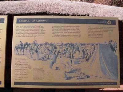
The 1775-76 expedition of Juan Bautista de Anza
made this site their one hundred first camp from
Horcasitas, Sonora, Mexico. Anza brought 198
colonists, located for Spain the Presidio of San
Francisco and Mission Dolores, and explored . . . — — Map (db m190721) HM
The Juan Bautista de Anza Expedition of 1775-1776 traveled with
240 settlers, soldiers, and others 1,800 miles from Sonora, Mexico
to Monterey, California. Anza then traveled with a much smaller
group to San Francisco and the East Bay to discover . . . — — Map (db m190230) HM
In 1775 and 1776, Lt. Colonel Juan Bautista de Anza, Father
Pedro Font, along with 240 settlers, soldiers, and others traveled
1,800 miles from Sonora, Mexico to Monterey, California. Anza
and Font, with a small group passed through by horseback . . . — — Map (db m145988) HM
Lt. Colonel Juan Bautista de Anza by Decree of Carlo III of Spain led an expedition near this site — the mission being to colonize the San Francisco Bay Area
In the center of the marker is a circular motif, designed by Doris Birkland . . . — — Map (db m24728) HM
Known as Santa Rosa De Las Lajas (Flat Rocks), this site was used on March 8, 1774 by the Anza exploring expedition, opening the land route from Sonora, Mexico, to Alta California. On December 11 to 15, 1775 the three divisions of Anza's colonizing . . . — — Map (db m62074) HM
Juan Bautista De Anza led two groups of Spanish explorers and settlers across this portion of the Colorado Desert from Northern Mexico to San Francisco Bay. During each tortuous passage, the Spanish camped below here in Yuha Wash. The passage in . . . — — Map (db m50683) HM
Used by the Kamias Indians who showed it to Anza's scouts on March 8, 1774. The second Anza Expedition passed here on December 11, 1775. Later an important water source on the trail from Yuma to San Diego. — — Map (db m50363) HM
Soldier, explorer and discoverer of the overland route from Sonora, Mexico to California. Leader of the first Spanish settlers who came through San Carlos Pass December 1775 on their way to Monterey.
Done for the love of California. — — Map (db m101462) HM
After successfully locating an overland passage to Alta California in 1774, Juan Bautista de Anza led 300 people and 1000 head of livestock on the first
overland colonizing expedition into California. This expedition resulted
in the . . . — — Map (db m200331) HM
Enlisted soldier Jose Vicente Feliz, his wife Maria, and their children were among the thirty Anza Expedition families. Maria was one of eight women who were pregnant. On October 23, 1775, the first night after leaving Tubac, tragedy . . . — — Map (db m142836) HM
The Arroyo Seco flows down from the San Gabriel Mountains to join the Los Angeles River on its way to the ocean. This spot, where the two rivers flow together, the “confluence”, is near the birthplace of the city of Los Angeles.
The . . . — — Map (db m145223) HM
The Upper Las Virgenes Canyon Open Space Preserve was part of the 113,000-acre Rancho San Jose de
Gracias de Simi tract granted to Javier, Miguel and Particio Pico by the King of Spain in 1795. The Rancho,
which was later transferred to Jose . . . — — Map (db m196844) HM
La Cienega — Mud Springs. Los Angeles - San Bernardino - Sonora Road stage station and campground, a place favored by the Indians.
Near here in 1774 and 1776
Juan Bautisa de Anza — trailblazer, colonizer — and his . . . — — Map (db m137504) HM
In January of 1776, San Gabriel Mission was host to trailblazer Colonel Juan Bautista De Anza and over 200 colonists and soldiers, enroute from Sonora, Mexico, to become the first residents of San Francisco. This was the first overland immigration . . . — — Map (db m67294) HM
Lt. Colonel Juan Bautista de Anza by decree of Carlos III of Spain led an expedition to this site - the mission being to colonize the San Francisco Bay Area. De Anza Expedition 1775 - 1776 — — Map (db m67293) HM
Lt. Colonel Juan Bautista De Anza by decree of Carlos III of Spain. Led an expedition to this site the mission being to colonize the San Francisco Bay Area. De Anza Expedition 1775 - 1776 — — Map (db m83335) HM
Lt. Colonel Juan Bautista de Anza by decree of Carlos III of Spain led an expedition to this site – The mission being to colonize the San Francisco Bay Area.
In the center of the marker is a circular motif, designed by Doris . . . — — Map (db m61384) HM
Lt. Colonel Juan Bautista de Anza by decree of Carlos III of Spain led an expedition near this site – the mission being to colonize the San Francisco Bay Area. — — Map (db m64415) HM
Lt. Colonel Juan Bautista De Anza by decree of Carlos III of Spain, lead an expedition to this site – the mission being to colonize the San Francisco Bay Area.
In the center of the marker is a circular motif, designed by Doris . . . — — Map (db m63230) HM
A native of Mexico de Anza left Tubac, Culiagan October 23, 1775 with a party of 240 together with horses, mules and beeves. Arrived Monterey March 10, 1776 with loss but one person. Journey of 1600 miles made under conditions of drought, snow and . . . — — Map (db m63566) HM
Lt. Colonel Juan Bautista de Anza by Decree of Carlo III of Spain led an expedition near this site — the mission being to colonize the San Francisco Bay Area
In the center of the marker is a circular motif, designed by Doris Birkland . . . — — Map (db m27188) HM
On March 16, 1774, Juan Bautista de Anza, Indian fighter, explorer, and colonizer, led through this pass (named by him San Carlos) the first white explorers to cross the mountains into California. The party traveled from Tubac, Arizona, to Monterey, . . . — — Map (db m143392) HM
On January 1, 1776, the first party of colonists to come overland to the Pacific Coast crossed the Santa Ana River south of this marker and camped between here and the river. Recruited in the presidios of Sonora, Mexico, and led by Lt. Col. Juan . . . — — Map (db m50995) HM
In 1775 and 1776 Lt Colonel Juan Bautista de Anza, Father Pedro Font along with 240 colonists, soldiers and others traveled 1,800 miles from Sonora, Mexico to Monterey, California. Anza then led a smaller party of soldiers to choose sites for the . . . — — Map (db m213060) HM
Lt. Colonel Juan Bautista de Anza by decree of Carlos III of Spain led and expedition near this site – The mission being to colonize the San Francisco Bay Area. — — Map (db m15366) HM
Somewhere in this narrow valley, perhaps on this very spot, the Anza Expeditions of 1774 and 1775 made their camps. Water for the 240 people and over 800 head of stock on the 1775 march was obtained from a series of wells, deeper than the height of . . . — — Map (db m51575) HM
This route was opened by Captain Juan Bautista de Anza and Father Francisco Garces in 1774. Anza's expedition of 1775, a group of 240 soldiers and settlers being led from Sonora to found San Francisco, encamped near this place El Vado (The Ford), . . . — — Map (db m51586) HM
This spring area was named by Captain Juan Bautista De Anza when his Overland Exploration party camped here on March 14, 1774. During the opening of the Anza Trail from Sonora into Alta California. Anza's colonizing expedition of 1775, consisting of . . . — — Map (db m50365) HM
Juan Bautista de Anza's expedition marched through this little pass December 19, 1775. On its way to strengthen Spanish colonization in California. Many of the 240 members of the party were recruited from Mexico to be the first residents of San . . . — — Map (db m51584) HM
The first ship to enter San Francisco Bay, the San Carlos (Captain Ayala), dropped anchor off this point August 5, 1775. Lieutenant-Colonel Don Juan Bautista de Anza planted the cross on Cantil Blanco (White Cliff) March 28, 1776. The first . . . — — Map (db m10742) HM
This place and its vicinity have abundant pasturage and fine water, all good advantages for establishing here the presidio or fort which is planned. It lacks only timber, for there is not a tree in all those hills...nearby the lake there are . . . — — Map (db m155202) HM
Lt. Colonel Juan Bautista de Anza by decree of Carlos III of Spain led an expedition to this site – The mission being to colonize the San Francisco Bay Area.
In the center of the marker is a circular motif, designed by Doris . . . — — Map (db m38533) HM
Hope on the Horizon
What would make a family leave their home for an unfamiliar land on a distant frontier? For the nearly 300 men, women, and children on the Anza Expedition, it was the chance for a fresh start. In 1775, life in northern . . . — — Map (db m38537) HM
The Anza Expedition of 1776, on its way up the Peninsula to locate sites for the Presidio and the Mission of San Francisco, camped here on March 26 at a dry watercourse a short league beyond Arroyo de San Mateo. Location: El Camino Real and Ralston, . . . — — Map (db m154364) HM
Here on the banks of San Mateo Creek Captain J. B. de Anza camped. March 29,1776, after exploring the peninsula and selecting the sites for the Mission and Presidio of San Francisco. Here also the party of families, soldiers, and priests, on the way . . . — — Map (db m18418) HM
Water in Alviso is a complex issue that touches on the environment, economics, and life safety. Already susceptible to flooding, Alviso’s situation was worsened by regional development. Hard paving, which prevented water absorption into the ground, . . . — — Map (db m24414) HM
Lt. Colonel Juan Bautista De Anza and Party crossed this area in March 1776 en route to select sites for the Presidio and Mission of San Francisco.. — — Map (db m130196) HM
This arroyo honoring San Joseph, patron saint of flight and students, was first discovered and traversed by Spanish explorers in 1769. On March 25-26, 1776 Colonel Juan Bautista de Anza made it his encampment No. 99 as mapped by his cartographer . . . — — Map (db m54025) HM
California had an ancient system of Paths made by migrating herd as they searched for food and salt. Native Americans later used these trails to hunt, gather, and trade for survival. European colonists improved these roads as they settled here. The . . . — — Map (db m209016) HM
[The Morgan Hill Centennial Project is a very unusual ‘marker’. It was created to celebrate the 100th anniversary of the incorporation of the City of Morgan Hill. One starts at the center of the marker and then proceeds along an expanding spiral . . . — — Map (db m46097) HM
Imagine eight months on a long distance road trip with five children and a van.
Now imagine doing it without modern convenience. No rest stops, no cars, no roads, no wheels of any kind. Juan Bautista de Anza led 30 families with over 240 . . . — — Map (db m100369) HM
Lt. Colonel Juan Bautista de Anza and party crossed this area in March 1776, en route to select sites for the presidio and the mission of San Francisco — — Map (db m212705) HM
Lt. Colonel Juan Bautista de Anza and party crossed this area in March 1778, in route to select sites for the Presidio and the Mission of San Francisco.
In the center of the marker is a circular motif, designed by Doris Birkland Beezley, of . . . — — Map (db m46135) HM
Lt. Juan Bautista de Anza and party crossed this area in March 1776. en route to select sites for the Presido and the Mission of San Francisco
In the center of the marker is a circular motif, designed by Doris Birkland Beezley, of a rider . . . — — Map (db m38342) HM
The Juan Bautista de Anza National HistoricTrail marks a 1,200 mile route that brought settlers to California from Tubac, in present-day Arizona, to what is now San Francisco.
The Spanish planned a system of Presidios, or military . . . — — Map (db m30147) HM
This parcel, known as the Bernal Adobe Site, is part of the Rancho Santa Teresa Historic District of Santa Clara County. Ancestors of Mowekma Ohlone Indians used this area as a large permanent cemetery and village site as long ago as 3,000 years due . . . — — Map (db m52767) HM
Lt. Colonel Juan Bautista de Anza by decree of Carlos III of Spain led and expedition near this site – The mission being to colonize the San Francisco Bay Area.
In the center of the marker is a circular motif, designed by Doris Birkland . . . — — Map (db m24727) HM
The Berryessa Adobe was built at a crossroad in California history. When constructed in the 1840s, Spanish colonial building traditions were blending with American influences. The builders constructed adobe walls on stone foundations and used soil . . . — — Map (db m52932) HM
Anza exploring party passed through the Saratoga area March 25, 1776. Lumbering in the mountains, which began 1847 and continued many years, brought the first settlers 1850. Among other industries established were lime quarry 1850s, grist mill . . . — — Map (db m2624) HM
Lt. Colonel Juan Bautista de Anza by decree of Carlos III of Spain led an expedition to this site – The mission being to colonize the San Francisco Bay Area.
In the center of the marker is a circular motif, designed by Doris . . . — — Map (db m30323) HM
For thousands of years, the Chumash Indians and their forebears lived in this valley. They have been described as a stone age people, hunters and gatherers, resourceful, friendly, fun-loving, astute traders, fine craftsmen, and expert rock artists. . . . — — Map (db m128414) HM