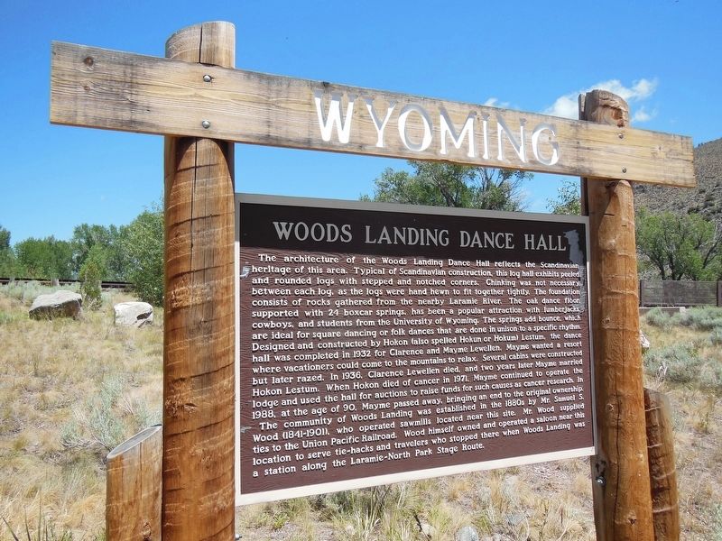
The architecture of the Woods Landing Dance Hall reflects the Scandinavian heritage of this area. Typical of Scandinavian construction, this log hall exhibits peeled and rounded logs with stepped and notched corners. Chinking was not necessary . . . — — Map (db m153399) HM
Founded in 1868 upon the arrival of the Union Pacific Railroad, Laramie was named after the fur trader Jacques LaRamie. The first female jurors served here in 1870 after Wyoming Territory in 1869, for the first time in history, gave women full . . . — — Map (db m67993) HM
Founded in 1868 upon the arrival of the Union Pacific Railroad, Laramie was named after the fur trader Jacques LaRamie. The first female jurors served here in 1870 after Wyoming Territory, in 1869, for the first time in history, gave women full . . . — — Map (db m76789) HM
This marker is made up of a dozen plaques embedded in a cement patio and a map of historic Laramie also embedded in patio. As each plaque has the same format, only a few of them have been illustrated.
1810-1820
French Canadian . . . — — Map (db m76849) HM
In memory of those who
passed this way to win
and hold the West
on the Fort Halleck-
Fort Laramie Road
Frontier town of
Rock Creek 10 miles
north east — — Map (db m89658) HM
Following Mormon settlement of the Salt Lake Valley beginning in 1847, church leaders envisioned colonization of the entire inter-mountain region. In following decades, Mormons emigrated from Utah into Idaho, Arizona and Wyoming. Seeking to improve . . . — — Map (db m91252) HM
In 1900, Lorenzo Snow, prophet and president of The Church of Jesus Christ of Later-day Saints, sent settlers to northern Wyoming under direction of Apostle Abraham Owen Woodruff. They were to establish two communities, Byron and Cowley, and build . . . — — Map (db m190064) HM
For at least 10,000 years, the area where Medicine Lodge Creek flows out of the Bighorn Mountains has provided a home for humans.
Discovering Ancient Cultures In 1968, the University of Wyoming began an eight-year archaeological . . . — — Map (db m163208) HM
The large rocks next to you are granite. These were formed within the earth's crust 1 billion years ago. Their exposure is the result of the eroding forces of wind, water, and ice. This granite contains quartz and resembles the rock containing gold . . . — — Map (db m91320) HM
Side A
One of the largest cattle operations in the Wyoming Territory, the Mason-Lovell Ranch moved its headquarters here in 1883. At its peak the ranch grazed cattle from Thermopolis, Wyoming to the Crow Reservation in Montana. . . . — — Map (db m91280) HM
In honor of
The Mormon Colonists
of the Big Horn Basin
who, under the leadership of
Abraham O. Woodruff, first camped near this site in May 1900. These pioneers, under many difficulties, established towns, notably Byron, Cowley and . . . — — Map (db m91255) HM
The presence of humans in the Big Horn Basin goes back more than 10,000 years. Evidence suggests that the prehistoric people were nomadic hunters and gatherers. Indians inhabited this area until 1878. In the late 1870s settlers, ranchers, and . . . — — Map (db m88172) HM
Water is a scarce commodity in the arid west. Wherever streams and rivers flow, you will find the pathways of early exploration and travel, the magnets of human settlement. Shell Creek is no exception. Archaeologists discovered evidence that . . . — — Map (db m88186) HM
By the late 1800s, settlers were already trying to wring a livelihood from the harsh environment in Shell Canyon and the valley below. Average precipitation here is less than ten inches per year and land suitable for cultivated crops is scarce. . . . — — Map (db m131490) HM
George Amos moved to Wyoming in the late 1800s to work as the foreman on the 4-J Ranch. A bachelor, he was a cowpuncher by day, and a voracious reader at night. In addition to a love for books, Amos subscribed to as many as 20 magazines and many . . . — — Map (db m203256) HM
Trivia Question! Where did cattle originate that were trailed to Wyoming? Long-horned cattle were driven up from Texas on the Chisholm, Western and Goodnight Loving Trails. Herefords were shipped from the British Isles and cattle . . . — — Map (db m242990) HM
"By mid-century most corporations wished to place themselves at arms length from the "company town" concept, in some cases it was neither possible nor desirable. A need existed. Many employees opposed being on the road for hours; they wanted to be . . . — — Map (db m242991) HM
"In the beginning when Wright was first taking shape and becoming its own place it was the spring of 1949 when the Wyoming Highway Department began constructing the Reno Junction Maintenance Camp. It was located about two and a half miles south of . . . — — Map (db m242956) HM
Gateway to the sites of Ghost Towns of the Copper Country. Once a favorite hunting ground of Prehistoric man, later "Camp le Grand" became a noted rendezvous of Indians and trappers. In 1897 the townsite was laid out by Willis George Emerson and . . . — — Map (db m95468) HM
Muddy Gap sits at a crossroads of many historic sites related to the Oregon and Mormon Trails. From Muddy Gap, Independence Rock is 18 miles northeast, Split Rock is 10 miles to the northwest; Devils Gate is 14 miles northeast, and Martin’s . . . — — Map (db m95472) HM
In the summer of 1867, a survey partly led by General Grenville M. Dodge seeking a route for the Union Pacific Railroad, stopped one half mile south west of here.
General John A. Rawlins, a member of the party, spoke of the spring there as the . . . — — Map (db m89705) HM
In the summer of 1867, a survey party led by General Grenville M. Dodge seeking a route for the Union Pacific Railroad stopped here.
General John A. Rawlins, a member of the party, spoke of the spring as "the most gracious and acceptable of . . . — — Map (db m67982) HM
During construction of the Union Pacific Railroad land speculators and a large contingent of undesirables kept pace with or move ahead of the construction crews and their military escorts. Townsite speculators tried to anticipate depot locations, . . . — — Map (db m89755) HM
At age 18, Fenimore Chatterton arrived in Wyoming on September 12, 1878 to begin a lifelong career of service to Wyoming.
The young Fenimore came west on the Union Pacific to Fort Steele for a bookkeeping job at the J.W, Hugus Trading Post. . . . — — Map (db m89995) HM
The south central portion of Wyoming has long been a travel corridor for prehistoric and historic people. Native American tribes from the Great Basin region to the west crossed this area to hunt buffalo on the eastern plains.
From 1810 . . . — — Map (db m67988) HM
Officially abandoned in 1886, the fort came under the jurisdiction of the Department of the Interior in 1887. In 1892 and 1893 most of the buildings were sold a public auction. In 1897 the land, opened to homesteading, was patented by the Union . . . — — Map (db m89913) HM
In 1901, the Fireman's Fund Insurance Company included a plat of Ft. Steel in its insurance rating of the town. The town had not grown as planned, probably due to the closeness of Rawlins and that the timber industry had started building its own . . . — — Map (db m89820) HM
In 1868 the Union Pacific Railroad was rapidly moving west with the short lived railhead towns leading the way. In early July, General Dodge ordered the citizens of Brownsville to move three miles from the river to the edge of the Dry Desert. This . . . — — Map (db m89916) HM
Douglas was founded as a result of the Fremont, Elkhart and Missouri Valley Railroad extension through central Wyoming in 1886. The railroad's objective was to access the mining and cattle-rich areas of Wyoming.
On August 22, 1886, the railroad . . . — — Map (db m92106) HM
The Oregon Trail crosses LaPrele Creek about one mile downstream from Natural Bridge. Before the modern road was built into the gorge, Natural Bridge was difficult to access, and it was only rarely visited by emigrants of the covered wagon era. From . . . — — Map (db m71495) HM
Caleb and Nancy Magill with their six children were part of a wagon train traveling fro Brown County, Kansas, to Dallas, Oregon, in 1864. After leaving Fort Laramie their three-year-old daughter Ada was taken sick with dysentery. At Deer Creek . . . — — Map (db m92079) HM
Nineteen-year-old Alvah Unthank was one of a group of young men who left Newport, Wayne County, Indiana, for the goldfields of California in 1850. On June 23 the wagon train passed Register Cliff, south of Guernsey. There Alvah inscribed his name: . . . — — Map (db m177934) HM
Three men named Sharp,
Franklin, and Taylor, and
one unknown man were
killed by Indians July 12,
1864 where the Oregon
Trail crosses Little Box
Elder Creek 2 1/2 miles S.W.
of here. They were buried
4 miles S.W. by the grave . . . — — Map (db m92087) HM
During the summer of 1874, General George Armstrong Custer led the first official government expedition to the Black Hills, which the Sioux Indians claimed as their territory. Although the United States Government officially sent this expedition of . . . — — Map (db m34586) HM
By 1911 the industrial production of coal at the Aladdin Mine was dwindling. Later coal mining at the site was for domestic coal for heating and cooking. The coal was reportedly "a good coal which burned so hot it made the stove top rattle." The . . . — — Map (db m98061) HM
Centrally located on the gold-bearing vein in the area, mines literally surrounded Atlantic City by the fall of 1868. The townspeople soon fostered a thriving business community. In addition to sawmills and blacksmith shops, Atlantic City boasted of . . . — — Map (db m80134) HM
In 1880, the population of Miner's Delight was 45, down from its peak of
around 100. One of the residents who remained through the 1880's was
territorial congressman James Kime. Kime, who settled here in 1869, is credited
as being Miner's . . . — — Map (db m173104) HM
Entering Miner’s Delight, you’ll be struck by the mystery and charm of an old west ghost town. The weather, brown logs command as much interest as a clear blue sky are reflected in the glassy surface of the beaver ponds. How do these buildings stay . . . — — Map (db m162424) HM
As the news of gold spread, the Sweetwater Mining District filled with miners who established Hamilton City about two miles east of here in 1867. The following year, the name of the town changed to Miners Delight, after a highly productive nearby . . . — — Map (db m80133) HM
The Historic Mine Trail and Byway Program designated the Gold Flakes to Yellowstone Historic Mine Trail in 2005. This trail links significant finds of gold, iron ore, and uranium, each of which played important roles in Wyoming's history.
The . . . — — Map (db m67009) HM
Ice Slough is a small stream that flows into the Sweetwater River five miles east of here. In front of this point is a slough (i.e. a marsh or shallow un-drained depression). This slough gave the name to the stream east of here. In the "Ice Slough" . . . — — Map (db m62076) HM
Home on the range, a tiny community consisting of a post office, gas station, and a few souls, sat quiet and undisturbed along this lonesome stretch of highway until the 1950's. That all changed when the nation's uranium industry boomed after World . . . — — Map (db m67008) HM
Originally called the Emigrant Road, the Oregon Trail was the main route of westward expansion from 1812 to 1869. An estimated 500,000 people journeyed past here in search of new lands and new lives in the West.
Because of its unique shape, . . . — — Map (db m62092) HM
Shoshone, Arapaho, Crow and Sioux Indians occupied this pleasant valley long before the Oregon Trail, which changed their cultures and life styles forever. This led to tragic warfare and the eventual loss of country they had called their own.
. . . — — Map (db m69602) HM
The Oregon Trail was American’s main street west. Building upon American Indians footpaths, emigrants bound for the Pacific Northwest used the trail. They were soon followed by Mormons fleeing persecution, gold seekers rushing to California and the . . . — — Map (db m95744) HM
To the south stand the Oregon Buttes, a major trail landmark. The name is significant because the Buttes were roughly the beginning of the Oregon Territory and also helped keep emigrants encouraged, even though there were still hundreds of miles of . . . — — Map (db m80499) HM
At 7000 feet above sea level, Rocky Ridge is the highest point on the Mormon and Oregon Trails. This elevation, lack of water, and rugged landscape presented a challenge to early pioneers. The trail over Rocky Ridge is approximately two miles long . . . — — Map (db m96621) HM
From where you're standing South Pass doesn't look all that remarkable. But compared to the rugged Wind River Mountains, it can easily be recognized as a type of gateway.
Nevertheless, crossing the Continental Divide into "Oregon Country" was a . . . — — Map (db m67020) HM
Even after the discovery of South Pass in 1824, it was years before the route was used extensively. Fur trapper/trader William Sublette brought a small caravan of wagons to South Pass in 1828. While his party did not take wagons over the pass, they . . . — — Map (db m67021) HM
South Pass was discovered in 1812 by a small band of Astorians led by Robert Stuart as they traveled east with dispatches for John Jacob Astor. It was “rediscovered” in 1824 by a party led by Jedediah Smith as they searched for a winter . . . — — Map (db m80501) HM
The trail over South Pass is a transportation corridor which served many purposes. In addition to being the route to Oregon and California, it was used by Mormon pioneers and by the Pony Express.
A great exodus to the Salt Lake Valley in 1847 . . . — — Map (db m67019) HM
The Oregon Trail
In memory of those who passed this way to win and hold the West
Plaque placed by the Historical Landmark Commission of Wyoming
1950 — — Map (db m80504) HM
With South Pass behind them, Oregon and California-bound travelers faced the second half of their journey. The roughest travel was yet to come. From Missouri to South Pass, emigrants were able to follow rivers. But from South Pass to Oregon and . . . — — Map (db m67018) HM
The Twin Mounds are a minor landmark along the Trail. These low hills on either side of the Trail helped keep emigrants headed in the right direction on the final climb to South Pass.
After the wagons passed between the Mounds, they fanned out . . . — — Map (db m237435) HM
The James G. Willie Handcart Company was rescued on October 21, 1856 by a rescue party sent by Brigham Young. 21 members of the Willie Company perished in this valley due to a severe winter storm and lack of clothing and food. Captain Willie left in . . . — — Map (db m96622) HM
In 1858, this ancient path, which had been used by Indians, explorers and mountain men as a short cut to the Snake River country was developed by Frederick Lander in to an alternate route on the Oregon Trail. What is commonly called the Lander Trail . . . — — Map (db m80161) HM
For many emigrants, the first tangible evidence that the had crossed South Pass was Pacific Springs, "the fountain source of the Pacific streams," according to pioneer Joseph Goldsborough Bruff. The broad expanse of the pass from Pacific Springs . . . — — Map (db m96660) HM
A region rich in history. A city rich in gold. From 1812 to 1868 this open country at the end of the Wind River Mountains provided a passage - the only passage - through the Rocky Mountain barrier of the Continental Divide for some 500,000 westering . . . — — Map (db m80160) HM
Founded 1868
A Great Gold Camp
Part of Wyoming’s historical heritage. Acquired for preservation May 18, 1966, with funds raised by Wyoming;s 75th Anniversary Commission Inc., its advisers, county committees and people of . . . — — Map (db m80162) HM
Emigrant travelers on their way west likely discovered small amounts of gold in the 1840’s, but it took until 1868 for the first mining claims to be staked. Word of the new gold rush spread and the summer of 1868 brought an influx of people from . . . — — Map (db m80148) HM
Captain James G. Willie’s Handcart Company of Mormon emigrants on the way to Utah, greatly exhausted by the deep snow of an early winter and suffering form lack of food and clothing, had assembled here for reorganization by relief parties from Utah, . . . — — Map (db m80154) HM
Oregon-Mormon Trail
and Sixth Crossing
of Sweetwater River
Willie Handcart Company rescue site, 21 October 1856 and burial site of John Winford and eight others from that company
John Linford
Born 28 August 1808 England
Died . . . — — Map (db m95742) HM
The Sweetwater Valley is the mid-section of the 2000 mile-long Oregon Trail. West of Casper, Wyoming, branches of that trail, meld into a single transportation corridor and here, paralleling the serpentine Sweetwater River, the trail approaches the . . . — — Map (db m95776) HM
Late in the year of 1856, the Willie and Martin Handcart Companies and the Hunt and Hodgetts Wagon Companies left Iowa City for their journey westward. Near this spot, these companies crossed the Sweetwater River for the sixth time, thus the name . . . — — Map (db m95743) HM
The building before you is the only surviving enlisted men's barracks at Fort Laramie. The building proper was completed in late 1874 and was designed to provide quarters and other needed support facilities for two companies of soldiers, The . . . — — Map (db m71018) HM WM
This building was completed in 1884. It was built as a commissary storage facility. As such it would have been primarily divided into two large storerooms: one for meat and one for flour, rice, and beans. Three or four smaller rooms would have been . . . — — Map (db m71017) WM
Fort Laramie was perhaps the single most important location in America’s expansion into the west. Founded in 1834 as a trading post, it became a military fort in 1849. Until it closed in 1890, Fort Laramie influenced major events in the history of . . . — — Map (db m71016) HM
We cannot afford to purchase wagons and teams as in times past. I am consequently thrown back upon my old plan – to make hand-carts, and let the emigration foot it . . . Brigham Young, 1855 Between 1856 and . . . — — Map (db m86981) HM
Mary Elizabeth Homsley was born near Lexington, Kentucky, July 20, 1824. She move with her parents, Jacob and Sarah Oden, to Truxton, Missouri, where she was married to Benjamin Franklin Homsley in 1841. In April 1852, accompanied by Mary's parents . . . — — Map (db m98361) HM
Between the years 1847 and 1868, most of the approximate 80,000 Mormon Pioneers passed through Fort Laramie. This was the first stop for the vanguard company after leaving Winter Quarters, (near Omaha) Nebraska.
In June, 1847, after following a . . . — — Map (db m79776) HM
"We proceeded (westward from Fort Laramie) and encamped outside the boundaries of Uncle Sam." So wrote Dr. J.S. Shepard in 1851 as he began the second leg of his journey west. "To leave Fort Laramie was to cast off all ties with civilization. It was . . . — — Map (db m98360) HM
Many emigrants journals and diaries from the 1840s to 1860s mention experiences such as; “nooning,” camping for the night, crossing over, or burying a loved one on the banks of Rawhide Creek. Of these experiences, death and disease were . . . — — Map (db m79704) HM
1336 miles - Nauvoo, Illinois to the Salt Lake Valley (Second plaque below:)
"Whether I live or whether I die all is well, all is well"
Elizabeth Rutledge 1806 - 1852 — — Map (db m98358) HM
This is an ORIGINAL HOMESTEAD SHACK built in 1909 about 28 miles south of Torrington on land which is now near the center of Hawk Spring Irrigation Reservoir. The house is 12' 7" x 12' 6" square and was home for the Trouts for 13 years. Here they . . . — — Map (db m164151) HM
In the 1870s, thousands of African Americans fled the poverty and racial unrest that followed the American Civil War to homestead on the plains of Kansas. These migrants were known as the Exodusters. Some intended to create separate, . . . — — Map (db m119890) HM
“Make it a good street. Make it wide enough to turn this damn team of mules around in.” (Henry “Sixteen Mule Team” Johnson) Thermopolis was named for the nearby hot springs by combining the Greek words thermo . . . — — Map (db m97782) HM
1890 - 1900
Ollie Koshear • Jesse Burson • Augernose Jane • J.A. McGrey • Jack Berry • Ralph Gellerno • Elton Perry • unknown woman • unknown man
ERECTED BY WASHAKIE CHAPTER
DAUGHTERS OF THE AMERICAN REVOLUTION
1962 — — Map (db m241043) HM
During the late 1800s, difficult travel and lack of housing did not discourage people from visiting the springs. Upon their arrival, some people pitched tents, while others cut temporary dugouts into the hillsides. Travelers entering the valley saw . . . — — Map (db m97709) HM
Near the base of the Bighorn mountain range, the City of Buffalo was founded in 1879 after the end of the Indian War Campaigns. Buffalo originally serviced soldiers from Fort McKinney located 3 miles south on the Bozeman Trail. In the years that . . . — — Map (db m97939) HM
As a local project to mark the 200th anniversary of the United States, this "Heritage Mall" was built across Clear Creek in 1976 as a reminder of national and local pioneers responsible for our freedoms and way of life. The Bicentennial Committee . . . — — Map (db m244197) HM
Before you is the “eighteen wheeler” of the 1860’s. It could haul 2000 lbs. to 5000 lbs. of weight depending on the grades of the trail. This model of the wagon was powered by oxen. Anywhere from 3 yokes (a yoke being two oxen) . . . — — Map (db m87708) HM
1869 - Occidental Hotel established as a tent in its present location alongside Clear Creek
1879 - First buildings constructed in what is now Buffalo
- Postal service established in Buffalo by President Hayes . . . — — Map (db m244120) HM
This marker is in the form of a timeline. The left to right timeline is presented here from top to bottom. Jenkins Family History is in italics text. Homesteading History is in normal text. History Milestones are in bold text.
1862: . . . — — Map (db m92236) HM
Buffalo, Wyoming, the Johnson County seat, chartered March 3, 1884, started as a trading center for Fort McKinney, located two miles west of town, which was founded July 18, 1887 and is now the Veterans' Home of Wyoming.
The court house was . . . — — Map (db m91499) HM
An independent cowboy, or small rancher, brands a calf on the open range. Surprised at his work, he turns to see a rider from a large cattle outfit galloping threateningly toward him.
Small ranchers, like this cowboy, rode south from Buffalo on . . . — — Map (db m225252) HM
274 entries matched your criteria. The first 100 are listed above. Next 100 ⊳