On West Main Street (Old U.S. 40) at Fisher Street, on the right when traveling west on West Main Street.
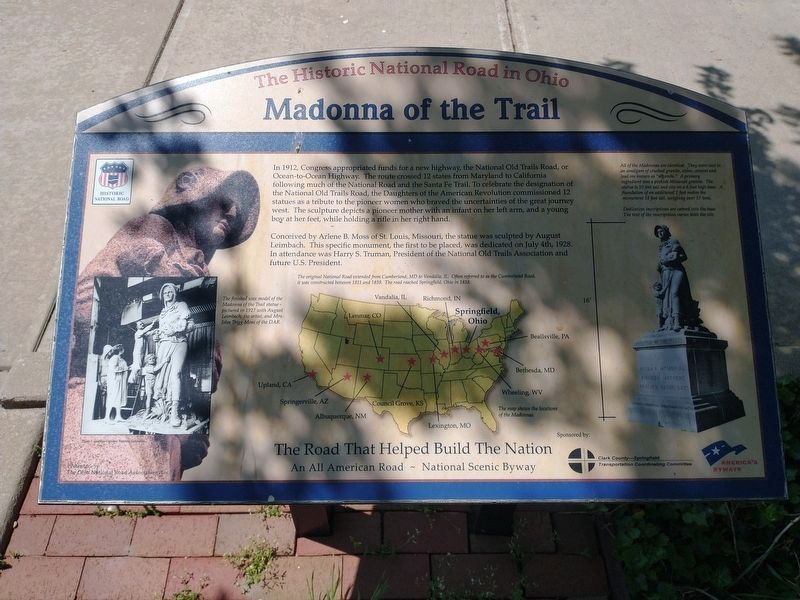
In 1912, Congress appropriated funds for a new highway, the National Old Trails Road, or Ocean-to-Ocean Highway. The route crossed 12 states from Maryland to California following much of the National Road and the Santa Fe Trail. To celebrate the . . . — — Map (db m45529) HM
Text on the Front (South) Side of Monument:
Madonna of the Trail
N S D A R Memorial
to the
Pioneer Mothers
of the
Covered Wagon Days
Text on the Left (West) Side of Monument:
The National Road
Completed by . . . — — Map (db m108458)
On Urbana Road (Ohio Route 72) north of Ohio Route 334, on the right when traveling north.
Famed Indian fighter, associate of Daniel Boone and George Rogers Clark, soldier of the Revolution and the War of 1812 - Leading settler of the Mad River Valley, built his first home in Ohio a few hundred feet east of this spot. — — Map (db m44113) HM
Near Urbana Road (Ohio Route 72) north of Ohio Route 334, on the right when traveling north.
Site of Simon Kenton's first log cabin home in Ohio - Built beside the old war trail over which he was led into captivity - Scene of his killing the last Indian slain in combat in Clark County — — Map (db m44177) HM
This bell from Springfield's first City Hall, located on this site in 1848, is placed here to honor the school children of Springfield and Clark County who participated in the Esplanade/Fountain Square Project.
Time capsule encased beneath this . . . — — Map (db m13356) HM
George Gammon (1803? – 1904) and his wife, Sarah Bradley (1808- 1902) built this house c.1850 on land purchased from her parents. The gammon and Bradley families were among the many free black Springfield citizens who actively operated the . . . — — Map (db m157027) HM
On North Fountain Boulevard at Ardmore Road, on the left when traveling north on North Fountain Boulevard.
The Ridgewood neighborhood, platted in 1914, was one of the first
fully planned and restricted suburbs in the United States. Its
innovative developer, Springfield native Harry S. Kissell, was among
a small group of nationally acclaimed real . . . — — Map (db m117567) HM
You are standing on the site of a cabin
built by John Keifer in 1824. John Keifer
(1802- 1863) and his wife Elizabeth Donnel
(1805- 1865), daughter of surveyor
Jonathan Donnel, resided here until 1830.
That year the family moved to another . . . — — Map (db m83854) HM
On West Main Street at Fisher Street, on the right when traveling west on West Main Street.
The Ohio Society DAR on July 4, 2003, placed this
Rededication Marker to Commemorate the
75th Anniversary of the Madonna of the Trail Statue.
The Statue has been restored through the efforts of:
• Ohio Society Daughters of the . . . — — Map (db m108425) HM
On West Main Street (U.S. 40), on the left when traveling west.
Pennsylvania House
David Snively built the Federal-style Pennsylvania House in 1839 along the newly constructed National Road. This tavern and inn was an important stopover for livestock drovers and pioneers traveling by foot, on horseback, or . . . — — Map (db m241911) HM
On West Main Street (U.S. 40) 0.1 miles west of Snyder Park Road, on the right when traveling west.
For nearly 80 years Clark County was home to a flourishing nursery and florist industry. In fact, Springfield and Clark County grew and shipped more roses than any other city in the country. Rose growing and shipping became a multi-million dollar . . . — — Map (db m215403) HM
On Lucy Run Cemetery Loop Road, on the left when traveling north.
The nearby Lucy Run School (1885) is an example of
the one-room schoolhouses that served rural Clermont
County from 1800 to 1930. Before an Ohio law
assessing taxes for public schools was passed in
1825, the first schools were by . . . — — Map (db m99693) HM
On Old Bullskin Trail (Ohio Route 133) at West Circus Street, on the left when traveling north on Old Bullskin Trail.
Resting here among other pioneers are:
Obed Denham,
native of Plainfield, New Jersey, donor of this plot, founder of
Bethel in 1798, and pioneer abolitionist;
Thomas Morris,
antislavery leader, veteran state legislator, U.S. senator . . . — — Map (db m224989) HM
On Ohio Scenic River Byway (U.S. 52) 0.1 miles east of Woods Hill, on the left when traveling east.
There rests here, in the quiet beauty of the
valley of the Ohio, the dust of a young girl.
On July 23, 1823, a wagon train, creaking
toward the west came to a halt close by.
When the train moved forward, one of its
party had been . . . — — Map (db m166841) HM
On Mount Moriah Drive, on the left when traveling east.
Clermont County
Bicentennial Marker
Chapel- Mt. Moriah United Methodist Church.
Organized in 1835 as the
Methodist Protestant Church
of Tobasco. Meetings were
held in a schoolhouse
until 1842, when the
church erected this small
brick . . . — — Map (db m99694) HM
On Ohio Route 133, 0.2 miles south of Edenton-Pleasant Plain Road (Ohio Route 727), on the left when traveling north. Reported missing.
The stone monument in the adjacent field commemorates the Bullskin trace, an old Indian trail used by Daniel Boone to escape the Shawnee Indians in 1778. Used by soldiers of General Anthony Wayne’s Army in 1793. It was made the Xenia State road in . . . — — Map (db m207762) HM
On Oakland Rd (Ohio Route 48), on the right when traveling east. Reported missing.
Col. Thomas Paxton (1739-1813) served with General
George Washington at Valley Forge in 1777 and with
General Anthony Wayne at the Battle of Fallen Timbers
in 1794. This was the last major fight against the
Indians before Ohio became a state in . . . — — Map (db m99423) HM
On Founders Drive at Valley Forge Drive, in the median on Founders Drive.
Clermont County
Bicentennial
Marker
White Pillars
circa 1840
Lt. Col. Thomas Paxton, 1736-
1813, settled this land in 1795
and is buried in the Paxton-
Ramsey cemetery. This Greek
Revival house was designed
by John Ramsey. . . . — — Map (db m99424) HM
Near Buckwheat Road, 0.1 miles north of Hunt Club Drive, on the left when traveling north.
Miami Township, established 1801, was one of five original townships in Clermont County. Among early settlers in Miami Township were the Leming family of New Jersey. In 1806, four Leming brothers—Ezekiel, John, Gabriel, and Charles—arrived here and . . . — — Map (db m187272) HM
On Ohio River Scenic Byway (U.S. 52) at Coffee Street, on the left when traveling east on Ohio River Scenic Byway.
Clermont County
Bicentennial Marker
Neville – 1812
The town is situated in the
first survey, No, 388, made in
the Virginia Military District of
Ohio. Nov. 13, 1787, John Obannon
surveyed a tract of 1,400
acres for Col. John . . . — — Map (db m99890) HM
On Front Street at Union Street, on the left when traveling east on Front Street.
Jacob Light (1756 – 1831) platted the Village of
New Richmond in 1814 on 85 acres he had bought
in 1804. His village streets ran at right angles
to the Ohio River.
Thomas Ashburn (1769 – 1826) bought 875 acres from
William Lytle next to . . . — — Map (db m99717) HM
On Ohio Route 232, on the right when traveling south.
Henry Clark Corbin Henry Clark Corbin was born September 15, 1842 and reared here on the family farm along Colclazer Run near Laurel. He attended public school and the private Parker Academy in nearby Clermontville. After teaching school and . . . — — Map (db m99622) HM
On Cole Road at 10 Mile Road (Ohio Route 749), on the left when traveling south on Cole Road.
An early crossroads settlement instrumental in
the development of Pierce Township. Located
at Dutch Creek and Ten Mile Road. The hamlet
consisted of a community water well, a general
store / post office (1860) and the Ten Mile
Presbyterian . . . — — Map (db m99698) HM
In memory of
Thomas Ashburn
born – Bolton, England, July 11, 1769
died – New Richmond, Feb. 15, 1828
founder of Susanna in 1816 and donor of this
riverside promenade and other parks and,
sites to be used, forever, for worship, . . . — — Map (db m99766) HM
On West Main Street (U.S. 50) at South Broadway Street (Ohio Route 132/276), on the right when traveling east on West Main Street.
The Owensville Village Hall was built as a Methodist Episcopal in 1859 and later
housed a Church of Christ. The village purchased the building in 1988 and utilizes it as village hall. On July 14, 1863, Confederate States General John Hunt Morgan’s . . . — — Map (db m95616) HM
On Ohio River Scenic Byway (U.S. 52) at Barlow Road (County Route 7), on the left when traveling east on Ohio River Scenic Byway.
Utopia was founded in 1844 by followers of French philosopher Charles Fourier (1772-1837). Fourierism, based on utopian socialism and the idea of equal sharing of investments in money and labor, reached peak popularity in the United States about . . . — — Map (db m164258) HM
Built 1800- 1802 at the homestead
of Maj. General William Lytle
by John Charles stone mason
The restoration of Harmony Hill
Dairy House is dedicated to the
memory of the “Father of Clermont
County”, Major General William . . . — — Map (db m95612) HM
On South Front Street south of West Main Street (Ohio Route 133), on the right when traveling south.
In 1805 John Charles built this stone house for Samuel Davies, brother-in-law of general William Lytle. During the War of 1812, the local militia met here. Simon Kenton sometimes attended these meetings. Military Courts of Inquiry met here until . . . — — Map (db m204902) HM
On Burdsall Road (County Route 25), on the right when traveling south.
In these fields on the southwest side of the east
Fork of the Little Miami River, opposite the mouth
of Grassy Run, was fought the Battle of Grassy
Run April 10, 1792. Simon Kenton led a group of
frontiersmen from Limestone (Maysville), KY . . . — — Map (db m95461) HM
On Aber Road (County Route 1) at U.S. 50, on the right when traveling north on Aber Road.
Dedicated to Christopher Hartman
who emigrated from Germany in 1753
fought in the American Revolution
and settled in
Clermont County in 1801;
to his grandson John Kirby Hartman,
who purchased this site in 1838;
and to their
relatives and . . . — — Map (db m99999) HM
This monument is dedicated to the pioneers who early in the year 1796 braved many dangers and suffered numerous hardships in order to establish the small settlement of Lytlestown, later to be named Williamsburgh, along the banks of the East Fork of . . . — — Map (db m108602) HM
On Glancy Corner Marathon Rd (County Route 54), on the right when traveling south. Reported missing.
Last Indian Battle
fought March 16, 1792 on the south
bank of East Fork Creek near the mouth
of Grassy Run Clermont County
Tecumseh Shawnee Chjef, known as
“Blazing Star”, and Simon Kenton, a scout,
were engaged in a sharp . . . — — Map (db m95462) HM
This is the stepping stone
from Revolutionary War veteran Adam Fisher’s log cabin.
After the war he and his family came to Kentucky and then
about 1799 moved across the Ohio River to settle between
Little Indian Creek and what is now route 743 . . . — — Map (db m95614) HM
Homestead of Major General William Lytle, known as the
“Father of Clermont County” for his many contributions
to the formation and settlement of the county. A surveyor
by profession, Lytle surveyed and acquired many acres of
land in Clermont. He . . . — — Map (db m95611) HM
On Shawnee Trace Road (County Route 263), on the right when traveling east.
Side A Descendants of Lemuel Garrison Sr., a Revolutionary War soldier, were among the first Europeans to own and settle land at Garrison Corner (intersection of State Route 123 and Shawnee Trace) . Garrison Cemetery burials took place from . . . — — Map (db m121044) HM WM
On Ohio Route 72, 0.3 miles north of County Road 156, on the right when traveling north.
Dedicated to the memory of these early Ohio Pioneer Residents of Clinton County
1841 William Geffs •
1882 William Geffs •
1864 Harrison Geffs •
1844 Harrison Geffs •
1908 Thomas Geffs •
1912 Mary Geffs •
1840 John Geffs • . . . — — Map (db m213425) HM
On Prairie Road (County Route 21) at Starbuck Road (County Route 11), on the left when traveling east on Prairie Road.
Near this site in October 1786 General Benjamin Logan with an army of 700 Kentucky volunteers camped on their way to destroy seven Indian towns in the Mad River Valley. During the night a renegade deserted the camp to warn the Indians. The army . . . — — Map (db m121033) HM WM
The 19th century saw a great migration of Quakers from the Carolinas and from eastern Ohio to southwestern Ohio. Attracted by rich soil and abundance of fresh water and springs, Quakers became the dominant religious group in the region. Clinton . . . — — Map (db m27837) HM
On Ohio Route 73 just west of Collett Road (County Route 232), on the right when traveling east.
Jonah’s Run Baptist Church.
The comingling of faiths in an area settled predominantly by
Quakers helps explain the origins of Jonah’s Run Baptist Church.
Ministered to by a Baptist preacher, the children and neighbors of
Daniel Collett . . . — — Map (db m141498) HM
On Springfield Road, 0.2 miles north of East Park Avenue, on the left when traveling north.
"Nature soon takes over if the gardener is absent."
Penelope Hobhouse
Pioneer plants are opportunistic and tenacious. They have the will and the means to take over the most inhospitable environment, . . . — — Map (db m245813) HM
On North Main Street (Ohio Route 164) at East Park Avenue (Ohio Route 344) on North Main Street.
Joshua Dixon selected this site in 1805 as the center for Columbiana. The first local post office, established at this museum location in 1809, pioneered free mail delivery in 1837.
The museum, an early log home in the village, was moved here . . . — — Map (db m268) HM
On Firestone Park, on the right when traveling east.
Built near this spring in 1810 by Benjamin and Rachael Dixon Hanna whose family were first settlers in this community in 1801 and 1802.
They were the grandparents of Marcus Alonzo Hanna United States Senator from 1897 to 1904 — — Map (db m48140) HM
On Springfield Road, 0.2 miles north of East Park Avenue, on the left when traveling north.
"Where there is water on Earth, you find life…"
Neil DeGrasse Tyson
When the Hannas discovered this spring, they likely found iris, marsh marigolds and skunk cabbage growing in the spring-fed pool and . . . — — Map (db m245809) HM
On Springfield Road, 0.2 miles north of East Park Avenue, on the left when traveling north.
The Legacy Trail Loop, an immersive and interpretive walking journey, invites you to meet the past stewards of the land we now call Harvey S. Firestone Recreational Park. There have been many, from the indigenous people who honored the land in . . . — — Map (db m245817) HM
Fawcettstown, later to become East Liverpool, marked the first Ohio community to be encountered by early river travelers as they headed toward new challenges and new lives in the expanding nation. Indian canoes, flatboats, and steamboats carried . . . — — Map (db m49713) HM
On Harvey Avenue (Ohio Route 39) 0.4 miles east of Bushwick Street, on the right when traveling east.
Land Ordinance of 1785. In April 1784, the Continental Congress adopted the Report of Government for the Western Territory, a broad plan drafted primarily by Thomas Jefferson for organizing the United States' new western lands that were ceded . . . — — Map (db m221421) HM
On Bacon Avenue (Ohio Route 46) 0.2 miles west of Everett Street, on the right when traveling east.
This circa 1840s log house, which now serves as a museum and home to the East Palestine Historical Society, was originally located at the corner of West Main and Walnut Streets. Some of its most notable and earliest residents were Dr. Robert . . . — — Map (db m111189) HM
On Major Road Northeast (County Road 250/822) at Great Trail Drive, in the median on Major Road Northeast.
Of Colonial Times, passed this way. It was the main route between the French Forts Duquesne and Detroit.It was also called the Tuscarawas Trail, since it crossed the Tuscarawas River at the old Indian town of Tuscarawas, near present day Bolivar. . . . — — Map (db m159642) HM
[Mural is on both sides of brick walls on the northern end of town that lie on both sides of the street:]
Wellsville Revitalization Committee Picnic
"Riverside"
Presbyterian Church, USA
525 Riverside Ave.
Founded April 5, 1831 . . . — — Map (db m156060) HM WM
On Main Street just north of Pine Valley, on the left when traveling north.
One of the largest known to exist in the U.S.A. Hidden for decades in the bell tower of this church edifice now representing the beautiful heritage of this masonic lodge and our proud city. Presented by past Master Francis C. Spring and Agnes . . . — — Map (db m156050) HM
On Chestnut Street, on the right when traveling east.
Around the spring nearby, was perpetrated, on April 20, 1781, the massacre of 20 Indians by Col. Daniel Broadhead's army of 300. This slaying was committed following destruction, the same day, of the two villages, Goschachgunk, (Coshocton) and . . . — — Map (db m14707) HM
On South 2nd Street (County Route 271) at Clow Lane, on the left when traveling south on South 2nd Street.
On this area stood Lichtenau, lost mission
of the Moravians, the first white settlement in
Coshocton County. It was established on April 12,
1776 by the Moravians Missionaries, Rev. David Zeis
berger and Rev. John Heckewelder, with eight . . . — — Map (db m157910) HM
On North Whitewoman Street north of Ohio Route 16/83, on the right when traveling north.
Nicholas Schott immigrated to Coshocton in 1838. He was a miller and assisted Arnold Medbery in building the Empire Mill. He lived in the original building which currently houses Canal Cargo. — — Map (db m206157) HM
On Chestnut Street (Ohio Route 541) west of North Water Street, on the right when traveling west.
On this site stood the Tavern of Charles "King Charley" Williams, first permanent white settler in Coshocton County. A native of Maryland, and born in 1764, Williams came here in 1801. He died in 1840. The dominant figure of his generation, he was . . . — — Map (db m344) HM
On Whitewoman Street, on the left when traveling north. Reported missing.
The Caldersburgh Pearl was dedicated in 2001 as a full-sized replica of a three-cabin canal freighter (65' x 14'). The name Caldersburgh Pearl has special significance to Roscoe's past. Caldersburgh was the name of the original community (early . . . — — Map (db m217365) HM
On Whitewoman Street, on the left when traveling north. Reported missing.
This house was built c.1825 by Daniel Boyd, a weaver. Some time in the 1830s, and in the face of financial difficulties, Daniel and Jane Boyd deeded the house to the Methodist Episcopal Church to be the church parsonage.
Originally located in . . . — — Map (db m217367) HM
On Whitewoman Street, on the right when traveling north.
From 1833-1841 this property was owned by Joseph Kerr Johnson, father of John and David Johnson of the Johnson-Humrickhouse Museum and no relation to Maro Johnson. Built c.1833-1838, the house and property were purchased by Maro Johnson and John . . . — — Map (db m27369) HM
On Whitewoman Street, on the right when traveling north.
In 1842, Maro Johnson purchased a portion of lot #2. The deed read that Johnson had to have the property paid for and a respectable building erected on it within one year. Those terms were met. The building became Dr. Johnson's office. — — Map (db m27382) HM
On Whitewoman Street, on the left when traveling north.
George LeRetilley, a Roscoe merchant and a son of James LeRetilley Sr, built this as his home in 1853.
It remains a private residence. — — Map (db m25621) HM
On Whitewoman Street, on the left when traveling north.
James LeRetilley Sr. purchased the building in 1849, a year before his death. In 1825, he moved to Caldersburgh from Muskingum County and opened a general store. He was the first postmaster in Caldersburgh (1826). After the canal opened, LeRetilley . . . — — Map (db m27381) HM
On Whitewoman Street, on the left when traveling north.
James Taylor, owner of a Coshocton woolen mill, built a house and possibly the fruit cellar on this lot in 1826. Taylor moved to California in 1840. Subsequent owners include David Frew, a miller, farmer, and a postmaster, and Daniel Rose, a . . . — — Map (db m27383) HM
On Whitewoman Street, on the right when traveling north.
Built in 1831, this “Old Warehouse” was used to store large quantities of grain, hides, wool and produce. There was a dry goods store on the upper level. Known as the “Mill Store” in the 1830's, this was the natural place . . . — — Map (db m27379) HM
On North Whitewoman Street at Hill Street, on the left when traveling north on North Whitewoman Street.
Whitewoman Street is named after a woman named Mary Harris, Mary Harris and her family were the first identifiable persons to live in the Coshocton county area, arriving there about 1745. They were Mohawks from Kahnawake, near Montreal, the . . . — — Map (db m206156) HM
On Main Street (U.S. 36) at Bridge street (Ohio Route 60), on the left when traveling west on Main Street.
In 1800, President John Adams granted 4,000 acres in the Walhonding Valley to William Simmons for his service to the United States of America as a Colonel during the Revolution, and for being one of five men appointed by President George Washington . . . — — Map (db m157850) HM
On Ohio Route 93 at Ohio Route 36 on State Route 93.
In the early 1770s, Chief White Eyes (Koquechagachton) of the Delaware tribe founded White Eyes Town approximately two miles southeast of this marker on a plain near present day West Lafayette. A friend of the Moravian leader David Zeisberger, White . . . — — Map (db m15175) HM
On County Route 254, on the right when traveling south.
Ohio Society
National Society
Colonial Dames XVII Century
Old Stone Fort
believed to have been built by
De’Iberville, LaSalle’s successor,
who built French forts in the
Mississippi Valley, 1679 to 1689.
He located one northeast . . . — — Map (db m89216) HM
On North Sandusky Avenue (Ohio Route 4) north of West Perry Street, on the left when traveling north.
Samuel Norton, Albijence Bucklin, their families & Seth Holmes arrived at this historic site October 17, 1819. The first log residence was built 130 feet southwest of this monument. The Abel Carey Tannery was built on this site in the summer of . . . — — Map (db m155298) HM
On Sandusky Avenue (Ohio Route 4) 0.2 miles north of Chatfield Center (Ohio Route 103), on the right when traveling north.
For centuries this area was used by Indian
tribes as a hunting ground. Vast swamp forests
of elm, ash, beech, pin oak, and maple lay on all
sides. To the east, a large cranberry bog was
covered by water most of the year. Indian
hunting camps . . . — — Map (db m119771) HM
On West Mansfield Street (Ohio Route 103) at Kibler Street (Ohio Route 602), on the left when traveling west on West Mansfield Street.
The Village of New Washington. Nicknamed "Dutchtown" for the many German families that settled in this area, New Washington was platted in 1833 by George Washington Meyers, who arrived in Cranberry Township in 1826. Prominent Austrian romantic . . . — — Map (db m179446) HM
On Dover Center Road at Bryson Lane, on the left when traveling south on Dover Center Road.
Joseph Calhoon brought his family from Vergennes, Vermont, to Dover Township in 1810, and they established themselves as the first permanent settlers in what would become Bay Village, Ohio. The Calhoon house, called Rose Hill, was built in 1818 and . . . — — Map (db m134288) HM
On Broadway Avenue (Ohio Route 14) at North Park Street, on the right when traveling east on Broadway Avenue.
The town of Bedford was settled in 1837. Early residents, Hezekiah and Clarissa Dunham donated the land that serves as Bedford Public Square. The Dunhams built one of the area's first homes in 1852, which stands at 729 Broadway with the letters H & . . . — — Map (db m137162) HM
For more than ninety years, this area was the heart and soul of Berea's sandstone quarries. In the early 1830s, John Baldwin discovered that the area's sandstone deposits made superb grindstones and building stones. in the 1840s, thriving sandstone . . . — — Map (db m5516) HM
The Triangle, one of the most historic places in Berea, has been the center of the city’s civic life since the mid-19th century. Just beneath lie the solid layers of the famous Berea Sandstone that brought prosperity to Berea durign its early years. . . . — — Map (db m53428) HM
On Broadview Road (Ohio Route 176) at Boston Road, on the right when traveling north on Broadview Road.
In 1811, Colonel John Breck sent Seth Paine to survey a new
township of the Western Reserve. Travelling from Massachusetts,
the Paine family journeyed by wagon pulled by a team of oxen,
a trip that took them forty-two days. For his . . . — — Map (db m137187) HM
Formed by erosion of Cleveland shale and cascading 48 feet, making it the tallest waterfall in the county, the Cataract Falls of Mill Creek powered the gristmill and sawmill built by William Wheeler Williams and Major Wyatt in 1799. The mills, . . . — — Map (db m21071) HM
On Shaker Square near North Moreland Boulevard, on the right.
Whose vision, courage, and deep appreciation of building well for tomorrow brought about the creation of Shaker Heights in 1911 and the development of Shaker Square in 1929.
Erected October 6, 1961, by the Shaker Square Association upon the . . . — — Map (db m17814) HM
Near East 9th Street north of Sumner Avenue, on the right when traveling north.
are credited with being Cleveland’s first permanent settlers. They arrived in Cleveland in 1797. They came to seek opportunity on the frontier, ax in hand, a rifle in the other and bible and spelling book in the saddlebag. Lorenzo Carter, . . . — — Map (db m192366) HM
On East 9th Street, 0.1 miles north of Erieside Avenue (North Marginal Road), on the right when traveling north.
Moses Cleaveland (1754-1806) served during the American Revolution as a captain in one of the three companies of Sappers and Miners in the U.S. Army Corps of Engineers. A native of Connecticut, Cleaveland graduated from Yale University before . . . — — Map (db m192562) HM
Near Robert Lockwood Jr Drive at West Superior Avenue, on the right when traveling south.
In 1796 Moses Cleaveland led a surveying party to the banks of the Cuyahoga River to lay out a new city. The map from the survey is depicted in the pavement below. — — Map (db m192508) HM
Near the foot of Merwin Avenue north of Center Street.
In July 1796, the first survey party for the Connecticut Land Company, led by General Moses Cleaveland (1754–1806), landed on the shore of Lake Erie near present-day Ashtabula to lay out the lands of the Connecticut Western Reserve. On July 22 . . . — — Map (db m136951) HM
On Merwin Avenue at West Street, on the right when traveling south on Merwin Avenue.
At this site was lock 44, the north terminus of the Ohio and Erie Canal from 1829 to 1872.
Lock 44 as the outlet of the canal into the Cuyahoga River and the first stop in the transportation system which linked the Great Lakes with the Ohio River . . . — — Map (db m17906) HM
On West Lakeside Avenue east of West 3rd Street, on the right when traveling west.
Fort Huntington Park is named for
Samuel Huntington
(1765-1817),
Governor of Ohio (1808-1810)
and member of the Huntington Family that founded the Huntington National Bank in 1866. He settled in
Cleveland in 1801 and eventually held . . . — — Map (db m213380) HM
On West 9th Street just north of West Lakeside Avenue, on the left when traveling north.
The Warehouse District of today is arguably the best physical remnant of 19th-century Cleveland. Although none of the residences built in that century remain, the early settlers’ street network is mostly intact.
In Cleveland's development . . . — — Map (db m192432) HM
On Ontario Street at Public Square (Rockwell Avenue), on the left when traveling south on Ontario Street.
The spire which rises above this tower stands as a tribute to those pioneers and early settlers of Cleveland, many of whom were members of this church, whose deep inner faith and resulting spiritual strength enabled them to lay the strong . . . — — Map (db m192273) HM
On West Mall Drive south of Lakeside Avenue East, on the left when traveling south.
On October 6, 1683, thirteen German families landed in America from Krefeld, Germany, on the ship Concord. This date is regarded as the beginning of German settlement. The Concord is considered the German Mayflower. Franz Daniel Pastorius, their . . . — — Map (db m182149) HM
Originally buried in Cleveland's first cemetery whose remains now rest in this lot.
Public reburial October 12, 1939 by Western Reserve Early Settlers Association. — — Map (db m17899) HM
On Martin Luther King Boulevard, on the right when traveling north.
Union and League
of Romanian Societies
The Union and League of Romanian Societies, Incorporated was formed in 1928 from a unification of two separate fraternal organizations, the Union and the League. The Union, founded on July 4, 1906, was . . . — — Map (db m18100) HM
On Euclid Avenue (U.S. 20) near East 69th Street, on the right when traveling west.
Dunham Tavern is the oldest building still standing on its original site in the City of Cleveland. Once a stagecoach stop on the old Buffalo-Cleveland-Detroit road (modern Euclid Avenue), the tavern dates from 1824. The structure was built by Rufus . . . — — Map (db m11818) HM
On Broadway Avenue (Ohio Route 43) at East 55th Street on Broadway Avenue.
North and South Broadway were originally part of Newburgh Township, organized in 1814 as one of the earliest settlements in Cuyahoga County. The contruction of the Ohio & Erie Canal and later railroads led to industrial and commercial growth, . . . — — Map (db m21073) HM
On Monroe Avenue at West 32nd Street, on the left when traveling west on Monroe Avenue.
Ohio City was originally part of Brooklyn Township, which was
founded by Richard Lord and Josiah Barber in 1818. The township
population increased rapidly with the completion of the Ohio Canal
in 1832. The “City of Ohio” became an . . . — — Map (db m136930) HM
On Pearl Road (U.S. 42) at Broadview Road, on the right when traveling north on Pearl Road.
Old Brooklyn has its roots in the original Brooklyn Township, organized in 1818. The first settlers came from Connecticut in 1812. Indian trails were the basis for what became Pearl, Broadview and Schaaf Roads. Brighton Village, centered around . . . — — Map (db m182199) HM
1375 entries matched your criteria. Entries 201 through 300 are listed above. ⊲ Previous 100 — Next 100 ⊳