On 41st Street near Piedmont Avenue, on the left when traveling south.
On this spot on June 1, 1904, the first Key Route electric train arrived to be welcomed by a crowd of excited residents. From a new ferry pier on the bay off Emeryville it had brought officials and guests to a dedication ceremony here. Key founder . . . — — Map (db m72279) HM
The railroad industry transformed Oakland from an oak forest to a thriving city. Rapid growth began when the Central Pacific Railroad absorbed local rail lines in 1868 and was granted right-of-way to build a freight and ferry pier. The Oakland . . . — — Map (db m19209) HM
On Second Street near Alice Street, on the right when traveling east. Reported permanently removed.
Railroad Heritage
The opening of the transcontinental railroad in 1869 reduced travel time between the East and West Coasts from as much as four months by sea to just six days. The Central Pacific made Oakland its western terminus. In 1871, . . . — — Map (db m71297) HM
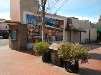
On 3rd Street near Washington Street, on the left when traveling east.
First Western Pacific transcontinental passenger train drawn by Engine No. 94 arrived in Oakland via Scenic Feather River Route August 22, 1910. Famed California Zephyr began operation in 1949. Adapted to restaurant in 1975. — — Map (db m72109) HM
On Third Street at Harrison Street, on the right when traveling north on Third Street. Reported permanently removed.
After winning a legal challenge to Southern Pacific Railroad's 50-year stranglehold on the
Oakland waterfront, Western Pacific Railroad Company inaugurated freight service in December 1909
and opened the Western Pacific Freight Office at Third and . . . — — Map (db m145512) HM
On Trestle Glen Road near Brookwood Road, on the left when traveling west.
The name Trestle Glen dates back to 1893 when Francis Marion "Borax” Smith's Oakland Traction Company extended a trolley line from downtown Oakland, up Park Boulevard to Grosvenor
Place. From a point just above where Holman Road crosses Grosvenor . . . — — Map (db m185171) HM
Imagine! Right where you are standing one of the world's longest interurban electric railroads called the Sacramento Northern Railway once ran. Along 185 miles of track, it operated between Oakland and Chico from 1912 to 1957. Service on this line . . . — — Map (db m153763) HM
On Jackson Street at 4th Street, on the right when traveling north on Jackson Street.
Where Rail, Road & Water Meet
The Waterfront Warehouse District developed as an intermodal distribution hub for the post, the railroads, and the local and regional roads. Coffee, rice, sugar, produce, meat, hides, burlap bags, paper, paint, . . . — — Map (db m228137) HM
On 3rd Street at Harrison Street, on the right when traveling east on 3rd Street.
Welcome to the Waterfront Warehouse District
For most of the 20th century Oakland’s Waterfront Warehouse District was a center for the collection and distribution of food products, capitalizing on Oakland’s strategic position as a center of . . . — — Map (db m228126) HM
On 3rd Street at Jackson Street, on the right when traveling east on 3rd Street.
Welcome to the Waterfront Warehouse District
For most of the 20th century Oakland’s Waterfront Warehouse District was a center for the collection and distribution of food products, capitalizing on Oakland’s strategic position as a center of . . . — — Map (db m228130) HM
On 5th Street at Jackson Street, on the right when traveling east on 5th Street.
Welcome to the Waterfront Warehouse District
For most of the 20th century Oakland’s Waterfront Warehouse District was a center for the collection and distribution of food products, capitalizing on Oakland’s strategic position as a center of . . . — — Map (db m228138) HM
On 3rd Street at Harrison Street, on the right when traveling east on 3rd Street.
The photo above overlays the 1909 Western Pacific Freight Depot in its original location, arguably the catalyst for developing the Waterfront Warehouse District as an intermodal Distribution hub.
After winning a legal challenge to Southern . . . — — Map (db m228122) HM
This depot was built in 1898 by Southern Pacific. Standing just east of the tracks off Davis St., it served San Leandro until passenger service was stopped. Donated to the S.L. Historical Railway Society, it was moved here and restored – 1988. — — Map (db m209197) HM
Near Kilkare Road near Main Street, on the left when traveling north.
In 1869, the first Transcontinental Railroad passed this spot on its way to the shore of the San Francisco Bay. In 1984 the Southern Pacific Railroad abandoned this historic line between Niles and Tracy, California.
Volunteers of the Pacific . . . — — Map (db m63766) HM
About 200 yards offshore, in what was once Silver Valley lies the Reynold’s House. This house appears on an 1878 General Land Office map and was probably one of the many road houses along the route that catered to tourists and travelers. Reynold’s . . . — — Map (db m10999) HM
On Ebbetts Pass Scenic Byway (State Highway 4), on the left when traveling east.
Named after Major John Ebbett and pointed out in 1853 to surveyor G.H. Goodard who referred to it as a “route of great promise – probably the best one for a transcontinental railway.”
No emigrant train used this route but a . . . — — Map (db m11444) HM
On North Church Street, on the right when traveling north.
Old No. 7 was the last steam locomotive to operate over the Amador Central Railroad between Ione and Martell. The twelve mile long railroad lies entirely within Amador County and is one of the shortest railroads in this country. Iron Ivan is a fine . . . — — Map (db m2371) HM
On Golden Chain Highway (California Route 49) at Martell Road, on the left when traveling north on Golden Chain Highway. Reported missing.
Started about 100 years ago as Ryan’s Station. In 1888 became known as Martell’s Station. This was the main terminal for stagecoaches from Amador County gold mines. Large shipments of gold bullion were made from Martell’s Station to San Francisco, . . . — — Map (db m70230) HM
On Gopher Flat Road, on the left when traveling east on Gopher Flat Road.
A man of tremendous ambition, Leland Stanford, Sr., was one of California’s most distinguished businessmen, politicians, philanthropists, and proponents of education. Lured to California by the Gold Rush in 1852, he became an owner of Sutter Creek’s . . . — — Map (db m12610) HM
Near Old Skyway Road near Old Depot Road. Reported missing.
In 1902, Diamond Match Co., established the Butte Co. Railroad. The So PAC tracks ran between Chico, Durham, and Stirling City. Regular train service between Chico and Magalia began Nov. 2, 1903. Magalia depot was completed soon thereafter. April 8, . . . — — Map (db m61223) HM
On Myers Street (Business California Route 70) at Kitrick Avenue, on the right when traveling south on Myers Street.
To Commemorate completion of 4th Railroad in California – Marysville to Oroville, by California Northern Railroad, later the Southern Pacific Co. 1st passenger train February 9 – 1864. Also marks site of Middletown 1854 – 1856. — — Map (db m190381) HM
On Black Olive Drive north of Pearson Road, on the right when traveling north.
Constructed in 1903, this depot is one of three maintained along the Butte County Railroad, a 31 mile line from Chico to Stirling City, completed by Diamond Match Co. in 1904. The railroad was later acquired by Southern Pacific and operated as a . . . — — Map (db m29671) HM
The rail yard housed the depot, a water tank, a stockyard, as well as a siding and spur. A motorcar house was located further up the track. The depot was retired on January 19, 1960.
The coming of the railroad was the major event that sparked . . . — — Map (db m29674) HM
On Railroad Flat Road north of Summit Level Road, on the right when traveling north.
This historic mining town, elevation 2,600 feet, was founded in 1849 and named after primitive, mule-drawn ore cars used here. The center of rich placer and quartz mining, its largest producer was the Petticoat Mine. As a result of black fever, . . . — — Map (db m239873) HM
On State Highway 12, on the right when traveling east.
The original three foot narrow gauge line was built by the San Joaquin & Sierra Nevada Railroad, extending from Brack’s Landing on the Mokelumne River, east to Valley Springs. The depot and turntable were built around the time of completion of the . . . — — Map (db m10635) HM
On Danville Boulevard at Hemme Avenue on Danville Boulevard.
In the late 19th century, local farmers, ranchers and businessmen began to campaign for a railroad into the San Ramon Valley. This plan came to fruition in 1890 when the Southern Pacific RR started construction of its San Ramon Valley line. . . . — — Map (db m153307) HM
The advent of trains determined the life or death of small communities in California. Antioch became doubly blessed when two different train routes came through the town. The San Pablo and Tulare Railroad first staked out the route between 1876 . . . — — Map (db m186006) HM
On Main Street near Holway Drive, on the right when traveling north.
At this location, in 1878, a railroad station was established for the San Pablo and Tulare Railroad, which ran from Los Banos to Martinez, later to become part of the Southern Pacific Railway, for the purpose of taking on water, and became known as . . . — — Map (db m17325) HM
On Sussex Street at Port Chicago Highway, on the right when traveling north on Sussex Street.
This monument commemorates what was once the only train stop in Clyde. The train that came through this stop in the early 1900's was owned by Southern Pacific and brought mail, passengers, and freight to this unique little town.
[Lower marker . . . — — Map (db m17341) HM
On West Prospect Avenue near Railroad Avenue when traveling north.
The 19.7 mile San Ramon Branch Line of the Southern Pacific Railroad was built through here in 1891. Original Danville station plat consisted of 8.65 acres.
Railroad service was terminated in 1978. The right-of-way was converted soon after to the . . . — — Map (db m93668) HM
On Iron Horse Regional Trail north of Fostoria Way, on the left when traveling north.
In 1891 the Southern Pacific San Ramon branch line opened from Martinez to San Ramon after local ranchers persuaded the railroad to build the line. It provided a better way to move people and goods in summer over stifling dusty roads and in winter . . . — — Map (db m251926) HM
On San Pablo Avenue at Ohio Avenue, on the right when traveling north on San Pablo Avenue.
Between 1904 and 1979, the Santa Fe Railway line was a busy place in El Cerrito. Santa Fe had two small stations and a three-track yard in the City. In this area, the railroad altered the creek channel. The presence of the railroad eventually . . . — — Map (db m94250) HM
On San Pablo Avenue at Portrero Avenue, on the left when traveling north on San Pablo Avenue.
In the early 1900s, streetcars ran the length of San Pablo Avenue. In those days, people could ride from the county line to Grand Canyon Park (now Alvarado Park) or out to MacDonald Avenue to the San Rafael Ferry. — — Map (db m94194) HM
Here, following the base of San Pablo Ridge, ran the tracks of the California & Nevada Railroad. Incorporated in 1881, its founders had grand plans to run from Emeryville to Nevada. The line never got farther than Orinda. Until ending service in . . . — — Map (db m94300) HM
These eucalyptus trees mark the route of the narrow gauge California and Nevada railroad chartered in 1884 to connect California to the Nevada mines.
Only 23 miles of track were completed by 1891 from Emeryville to Bryant now Orinda. In addition . . . — — Map (db m133653) HM
Near Marina Vista Avenue near Castro Street, on the right when traveling west.
The City of Martinez has been the home of a train station along the waterfront for 125 years. The first station (approximately 200 yards to the east of this site) was erected in 1876 and closed in 2001 when this station was opened.
More than . . . — — Map (db m93542) HM
On Ferry Street near Marina Vista, on the right when traveling north.
First located here April 28, 1876 by Central Pacific R.R. First passenger train passed through on September 25, 1877 with Leland Stanford aboard.
Historic Marker No. VI
Martinez Historical Society
July 4, 1991 — — Map (db m19225) HM
Freight railroads serviced the Moraga Rancho from 1889 to 1957.
Passenger service to the Moraga Station began in 1913.
Commuters, high school and St. Mary's College students rode
the train in the early days, as well as picnickers going . . . — — Map (db m152671) HM
On this site was the Moraga Train Station of the
Sacramento Northern Railway, a 183-mile railway
that connected Oakland and Chico via Sacramento,
handling passengers and freight.
The station served Moraga Valley from 1913 to 1957. . . . — — Map (db m184241) HM
On Moraga Way at Vashell Way, on the right when traveling south on Moraga Way.
Bryant Station was the terminus of the California and Nevada Railroad, a narrow-gauge steam line which transported local harvests to the Emeryville docks. The railroad, formed in 1881, was originally planned to run passengers and freight to the . . . — — Map (db m24647) HM
Just east of this monument is the last
remaining original post from the C&N
Railroad trestle structure. The C&N
was incorporated on March 25, 1884.
J.S. Emery was listed as the railroad's
president, for which present day
Emeryville is named. . . . — — Map (db m144979) HM
On Bates Boulevard at Davis Road, on the right when traveling south on Bates Boulevard.
The de Laveaga train station, built in the 1880s, is the last remaining station of the narrow gauge California and Nevada Railroad line that linked Emeryville to Orinda. Passengers often traveled to Orinda on weekends for picnics and vacations in . . . — — Map (db m221975) HM
On Davis Road at Bryant Way, on the left when traveling east on Davis Road.
Did you know that Orinda once had a railroad?
This building is the only remaining station of the California & Nevada
Railroad. The C&N, a narrow gauge line constructed in 1890, ran 23
miles between Emeryville and Orinda hauling farm . . . — — Map (db m123143) HM
Beginnings
Initially built from Avon to San Ramon to serve the agricultural
interests of San Ramon and Diablo Valley the line was later
extended south to the community of Radum, now known as
Pleasanton. The line was approximately 30 miles . . . — — Map (db m153747) HM
On Doran Drive near Western Drive, on the right when traveling south.
San Francisco Bay is known for more than its great beauty. Its large estuary, where sea water mixes with huge river flows, is also a major port.
Richmond's deep natural waterfront lent itself to early industrial development. Augustin Macdonald . . . — — Map (db m94738) HM
Before bridges spanned the Bay, ferries and trains once linked
San Francisco with the rest of the nation. At that time, the Bay
Area boasted the world's largest ferry system.
Here, at Ferry Point ship and rail met in 1900 when Santa Fe
tunneled . . . — — Map (db m152761) HM
"We didn't think
the streets were paved with gold or anything,
but we thought in California we could mix and mingle and get along."
Wilbur Wheat
The Southern Pacific Railroad Depot – Richmond's historic gateway -
greeted . . . — — Map (db m153482) HM
This inclined shaft, known as Eureka Slope, was the entrance to the Eureka Coal Mine. Between 1860 and 1895, more than 150,000 tons of coal were hoisted to the surface. The slope is 290 feet long and descends at a pitch of 32 degrees. It was fitted . . . — — Map (db m198217) HM
On Civic Drive near North California Boulevard, on the left when traveling east.
Electric rail service came to Walnut Creek in 1911. The railway (later called Sacramento Northern) provided passengers and freight service from Sacramento through Walnut Creek and on to Oakland and the San Ramon Valley. The tracks run along today's . . . — — Map (db m93754) HM
On North Broadway near Mt. Diablo Boulevard, on the right when traveling south.
The first passenger train rolled into Walnut Creek in 1891. Southern Pacific built the train depot later that year on a site that was across the creek (now under Broadway) and close to this plaza. The depot was converted to commercial uses and . . . — — Map (db m93738) HM
On South Shingle Road near Elvira Street, on the left when traveling east.
The youngest town acquisition of El Dorado County owes its origin to the Placerville and Sacramento Valley Railroad. They established a station for neighboring Amador County at this crossing of the roads. The town started on the completion of the . . . — — Map (db m19317) HM
On Pony Express Trail, on the left when traveling east.
Scene of the robbery of two coaches of the Pioneer Stage Line running between Virginia City, Nevada, and Sacramento, California, on the night of June 30, 1864, at about ten o’clock. Perpetrated by a gang of fourteen men, eight sacks of bullion and . . . — — Map (db m13922) HM
On South Clovis Avenue at 4th Street, on the right when traveling north on South Clovis Avenue.
Built in 1892 as one of the three depots along the line of the San Joaquin Valley Railroad, this structure was originally located on the Tarpey Ranch just southeast of what is now the intersection of Ashlan and Clovis Avenues. In the span of its . . . — — Map (db m101992) HM
Near South Clovis Avenue (State Highway 168) near Villa Avenue, on the left when traveling north. Reported missing.
In 1891, Marcus Pollasky formed a company to construct a railroad from the junction of the Southern Pacific Co. tracks in Fresno to the Sierra with the idea that eventually the railroad would cross the mountains and open the San Joaquin Valley to . . . — — Map (db m28017) HM
On West Elm Street just east of 7th Street, on the left when traveling west.
This is the approximate site of Coaling Station A established by the S.P.R.R. in the late 1880’s from which the City of Coalinga derived its name. — — Map (db m229469) HM
On South 5th Street just south of East Forest Street, on the right when traveling north.
In the 1880’s coal was being mined in the hills of southwestern Fresno Co. In 1888 the Southern Pacific Railroad extended it’s line from Goshen to Alcade, south and west of present day Coalinga. A spur line was built from the mine to the railhead. . . . — — Map (db m64084) HM
On East Merced Street at South 7th Street, on the right when traveling north on East Merced Street.
In 1872, the old Central Pacific Railroad, forerunner of the Southern Pacific, constructed a north-south line through the San Joaquin Valley, which opened the valley to commerce and settlement. The railroad contructed a switch a short distance . . . — — Map (db m26132) HM
"Fresno" is the Spanish word for "Ash Tree." The first settlement to which the name was applied was "Fresno City," a station on the old Butterfield Stage Route located on Fresno Slough about one and one-half miles northwesterly from the present . . . — — Map (db m41007) HM
On this spot in the early days was a flowing spring beside which stood a large green bush. Wild horses, deer, elk and antelope watered here and it served as a watering place for sheep and cattle.
The presence of this water caused the . . . — — Map (db m291108) HM
On Tulare Street near Van Ness Avenue, on the right when traveling west.
During and after World War II, nearly 5,000,000
contracted braceros came to work in agriculture
and on the railroads, the majority in California and
the San Joaquin Valley, under U.S. and Mexican Treaty,
demonstrating their patriotism . . . — — Map (db m41067) HM
On Fresno Street near L Street, on the right when traveling east.
La Ville d'Etamps
a l'Amerique
This monument from General Patton's Route of Liberation is a gift of the people [of] Cannes, France to the people of California, sent via La Train de la Reconnaisance Francaise (Merci Train) and dedicated . . . — — Map (db m131236) HM
This is one of the French boxcars of the French Merci Train sent to the United States. in 1949 as a thank you token to the American people for the Freedom Ship of food and clothing sent to France in 1948. The car was filled with many articles of . . . — — Map (db m197216) HM WM
This French Merci Train Boxcar cover is dedicated to all veterans, past, present, and future, as a symbol of tribute to those who have, are now, and will in the future, borne the battle of war and conflict in the preservation of our nation. May the . . . — — Map (db m198102) WM
On Divisadero Street at Broadway, on the right when traveling east on Divisadero Street. Reported missing.
Fresno means ash tree in Spanish. For many years, this section of California was known as the "Fresno Country” because of the ash trees that grew along its waterways. One of its rivers was named Fresno. Fresno City was established on the west side . . . — — Map (db m229390) HM
On Huntington Boulevard near First Street, on the left when traveling east.
During the year 1903, streetcars began to rattle along the city streets from the San Joaquin River through the fig garden area to downtown Fresno and east along Huntington Boulevard to Sunnyside.
Providing a reliable, entertaining, even . . . — — Map (db m27830) HM
Founded by the Pacific Improvement Co. following the completion of Southern Pacific's east side railroad in May 1888. Its name honors Joseph Sanger, Jr., Indiana rail executive. Sanger, supported by a rich fruit citrus farming district which later . . . — — Map (db m28164) HM
Be it known that at this site in Dec. 1854 work began on the Union Plank Walk Railtrack and Wharf Co. The railroad, in use by Jan. 1855, was the earliest operating state authorized railroad in California. The wharf, completed in May 1855, was 1.5 . . . — — Map (db m248874) HM
On Railroad Avenue at F Street when traveling north on Railroad Avenue.
Incorporated December 15, 1854, as the Union Plank Walk, Rail Track, and Wharf Company, the Arcata and Mad River Rail Road is the oldest line on the north coast. Originally using a horse-drawn car, the railroad served as a link between Humboldt Bay . . . — — Map (db m113364) HM
On Fields Landing Drive at Railroad Avenue, on the left when traveling south on Fields Landing Drive.
Built in the late 1870's or early 1880's, the Fields Landing Hotel originally was used house rail train passengers bound for Eureka. They then continued on by boat to Eureka. In 1913 the railroad was extended to Eureka. The Fields Landing Hotel was . . . — — Map (db m108026) HM
Bert Vaughn of Jacumba built the stone tower in 1922-23 to commemorate the pioneers and road and railroad builders who opened the area. In the 1930s W.T. Ratcliffe carved the stone animal figures which lurk in the rocks surrounding the tower, . . . — — Map (db m149171) HM
On Mortero Canyon Road just south of Highway S-2, on the right when traveling south.
Welcome to Mortero Wash in Anza-Borrego Desert State Park. The volcanic landscape you see in this section of the desert posed a significant challenge for travelers.
Undeterred, John D. Spreckels had an ambition to build a railroad that . . . — — Map (db m193810) HM
On California Route 168 1.9 miles east of U.S. 395, on the right when traveling east.
Zurich Station, formerly Alvord, was established in 1884 as a freight and passenger station on the Carson & Colorado Railway - known locally as "The Slim Princess."
Zurich was the main railroad station for Big Pine and points east. Its name . . . — — Map (db m92763) HM
Constructed by George Martin as
a store in Chalfant with material
salvaged from two Laws warehouses.
Moved to Laws in 1977.
Adopted by
Jamie and Leanna Albrecht Beaber
2024.
This building was
built with old
lumber from . . . — — Map (db m288485) HM
In 1883 the Carson and Colorado Railway Co. completed the building of the
narrow gauge line from Mound House
Nevada to Laws, which was originally
called Bishop Station. Laws was named
in honor of R.J. Laws, assistant superintendent of the . . . — — Map (db m288467) HM
In 1883 the Carson & Colorado Railroad was built between Mound House (near Carson City, Nevada) through Laws to Keeler, California, a distance of 300 miles. Laws Station was named in honor of Mr. R.J. Laws, Assistant Superintendent of the . . . — — Map (db m10333) HM
On Pine Street east of U.S. 395, on the left when traveling east.
The Slim Princess “Engine 9” was built in 1909 and first saw service on the 36 inch narrow gauge rails (standard gauge is 4 feet 8 ½ inches) of the Nevada, California and Oregon Railroad. It came to the Mina Branch of the Southern Pacific in 1929 . . . — — Map (db m78315) HM
This turntable is what is known as an "Armstrong" turntable. In
other words, the turning power is the strong arms of a few
people. If the locomotive or car to be turned is balanced
properly on the table, four men can easily turn a 40 . . . — — Map (db m288469) HM
On State Highway 127 0.2 miles south of State Highway 190, on the right when traveling south.
This historic crossroad has been used by Indians, Clampers, Death Valley 49ers, ranchers, farmers, settlers and tourists. The town was originally called Amargosa. In 1907, the name was changed to Death Valley Junction. At this junction, the Tonopah . . . — — Map (db m78583) HM
On Grant Street at Onion Valley Road on Grant Street.
An oil burning steam locomotive, built by Baldwin in 1911, was purchased by the Southern Pacific R.R. in 1928 to haul passengers and freight along the 300 mile narrow gauge line, known locally as the “Slim Princess”. Jim Butler of Tonopah said, “It . . . — — Map (db m52099) HM
Built originally as a stagecoach depot in 1866, it evolved into a railroad station in 1883 to carry freight and passengers on the Carson & Colorado Railroad line, known locally as the "Slim Princess". It served the Independence community from 1883 . . . — — Map (db m72573) HM
On Malone Street just south of Railroad Avenue, on the left when traveling south.
From Mound House, Nevada, narrow gauge rails of the Carson & Colorado Railroad reached this site in 1883. Cerro Gordo and other mines faltered, the rail line fell on hard times, so plans to extend the line to Mojave were abandoned, leaving Keeler as . . . — — Map (db m72574) HM
On Old State Highway west of Malone Street, on the left when traveling west.
In 1865 Pablo Flores found the richest vein of silver
California has ever had ($17 million) overlooking
Owens Lake at the crest of the Inyo Mountains. By 1868
Cerro Gordo Landing was growing to supply the mines.
Water went up the "Yellow . . . — — Map (db m221858) HM
The region yielded other resources as well, like grazing land, soda ash, trona, and borax. Weatherworn cattle chutes, abandoned mines and factories stand as testament to past human activity. Cerro Gordo remains a ghost town. In Keeler, the . . . — — Map (db m221908) HM
On California Route 178, on the right when traveling north.
Located at Metbury Spring on the Tonopah and Tidewater Railroad, Shoshone was founded in 1910 by Ralph Jacobus "DAD" Fairbanks. After the collapse of the mining camp of Greenwater (approximately 20 miles northwest of here), "DAD" Fairbanks came . . . — — Map (db m78511) HM
Situated at the southern end of the San Joaquin Valley, Kern County was part of a natural corridor for a railroad running between San Francisco and Los Angeles.
The Southern Pacific Railroad began laying track southward from San . . . — — Map (db m25117) HM
The Chinese community was an early and significant element of the population of Kern County.
Chinese immigrants contributed to the social, economic and industrial growth of Kern County by mining, farming, building railroads, and owning . . . — — Map (db m25318) HM
On Chester Avenue, on the left when traveling north.
As railroad service expanded across the United States, railroads took precautions to ensure safe transportation for travelers and freight.
A railroad flagman notifies travelers of an approaching train and directs rail, automobile and pedestrian . . . — — Map (db m237366) HM
Railroad yards are highly specialized facilities consisting of engine maintenance buildings, fueling areas, track and switching areas and material storage yards.
This scale house was used in the Santa Fe Railroad switchyard in . . . — — Map (db m25636) HM
The caboose was an office, a lookout, and a home away from home for a train crew.
In the days before automatic air brakes, the engineer signaled the caboose with his whistle when he wanted to slow down or stop. A brakeman would then . . . — — Map (db m25598) HM
This locomotive, among the largest and most powerful on the Southern Pacific Railroad system, supported the growth and development of the San Joaquin Valley and the West.
Engine #2914, called a 4-8-0 because of its wheel . . . — — Map (db m25600) HM
Approximately 3,000 men labored on railroad construction up and over the Tehachapi Mountains in the 1870s.
It took over three years for the line to be completed through Kern County. As the railroad slowly progressed through the county, . . . — — Map (db m25606) HM
Named for Edward F. Beale, this station on the Southern Pacific rail line was established in 1876 as a depot and telegraph office. Service was discontinued in 1943. Beale was Superintendent of California Indian Affairs during the 1850’s. In 1865 he . . . — — Map (db m119218) HM
On Bealville Road, on the right when traveling east.
Originally known as Allen's Camp after Gabriel Allen, who in the 1870s had a cabin and stock pasture near here, the settlement was named Caliente when railroad construction reached this point in April 1875. The town became a railroad terminal for . . . — — Map (db m157683) HM
Near Broome Road 0.5 miles north of Woodford-Tehachapi Road, on the left when traveling north.
In memory of conductor Everett S. Crown, brakeman Allan R. Riess, who lost their lives in a tragic train wreck in San Bernardino Calif, May 12, 1989. — — Map (db m255660)
On Central Valley Highway at Poso Avenue, on the right when traveling north on Central Valley Highway.
This building originally located four blocks southeast of
this site was opened for use and dedicated October 11, 1917.
Until closed in 1978, this building served as Shafter’s
gateway to the world as the mail, Western Union Telegraph,
express, . . . — — Map (db m130325) HM
On Green Street, on the left when traveling north.
Green Street was named for Peter D. Greene, who came to the Tehachapi Area in 1856, when he set up camp in Mormon Gulch near Tehachapi where he prospected for gold (named after a company of Mormons who had previously prospected for gold there.) He . . . — — Map (db m136213) HM
On South Curry Street, on the right when traveling east.
Built by Joe Gallinger in 1880, it was purchased in 1926 by Jim and Lucinda (Callie) Wiggins Brite. Upon Lucinda's death in 1944, the Davis family purchased the house. It was customary to drive sheep and cattle along Curry Street to the railroad . . . — — Map (db m52890) HM
On East F Street, on the left when traveling east.
1906-1914: City of Los Angeles builds and operates plant to make cement for Los Angeles Aqueduct and also constructs town named Aqueduct to house workers and families.
1910: Aqueduct train station and post office are renamed Monolith. . . . — — Map (db m52988) HM
On Tehachapi Boulevard, on the right when traveling west.
This style of telephone booth was unique to Southern Pacific Railroad. Untold hundreds were manufactured at the West Oakland Maintenance of Way Shops. Inside each booth was a Western Electric model 1517 BU wood-encased telephone with a hand-cranked . . . — — Map (db m232280) HM
On West Tehachapi Boulevard at North Green Street, on the right when traveling north on West Tehachapi Boulevard.
Erected in 1904 to replace a former depot destroyed by fire, the Tehachapi Depot served the community until its use as a station was discontinued in 1971. In 2004, a local group began the process of obtaining the depot from Union Pacific. Upon . . . — — Map (db m121882) HM
10689 entries matched your criteria. Entries 401 through 500 are listed above. ⊲ Previous 100 — Next 100 ⊳