Near Baxter Avenue (U.S. 31E/150) at Cherokee Road, on the right when traveling north.
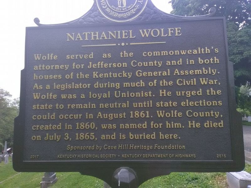
Born in Richmond, Va., on October 29, 1810, Wolfe was one of the first two graduates of
the University of Virginia School of Laws in 1829. After law school, he came to Kentucky to begin his law practice. He was a highly respected criminal . . . — — Map (db m161217) HM
On Taylor Boulevard at Marret Place, on the right when traveling south on Taylor Boulevard.
Southern Parkway
Originally named Grand Boulevard. Completed on June 14, 1893. It was 150 feet wide. Constructed of packed dirt and watered daily to keep the dust down. Lined with large trees, flanked to the east with a bicycle path, to the . . . — — Map (db m161570) HM
On West Kenwood Drive at Kenwood Hill Road, on the right when traveling east on West Kenwood Drive.
The Little Loomhouse
Lou Tate Bousman (1906-79), born in Bowling Green, Ky. During Arts & Crafts movement, at Pres. Hoover’s request, she traveled Appalachia preserving historic coverlet patterns. Her work with Mrs. Hoover led to the . . . — — Map (db m161569) HM
On Amphitheater Road at Golf Drive, on the right when traveling south on Amphitheater Road.
Iroquois Amphitheater
The official amphitheater of Ky., it was built in 75 days by 275 WPA employees. It opened with a sold-out production of Naughty Marietta on July 4, 1938. The main attraction was the dazzling water curtain. In . . . — — Map (db m161571) HM
On Southside Drive (State Road 1020) at Southside Drive (State Road 907), on the right when traveling north on Southside Drive.
The Kenwood Drive-In opened July 31, 1949, featuring the movie El Paso. Construction cost $100,000. At 71 ft. high and 72 ft. wide, the screen was billed as the biggest in the south and could withstand 100 mph winds. It was Louisville’s last . . . — — Map (db m161568) HM
On West Kentucky Street west of South 7th Street (Kentucky Route 1931), on the right when traveling east.
Located on original site of Simmons University and Bible Collège, a black institution. Opened Feb. 9, 1931, as the segregated branch of University of Louisville in response to black political activism. It was third municipally supported college for . . . — — Map (db m203388) HM
On West Kentucky Street at South 6th Street, on the right when traveling east on West Kentucky Street.
Designed in 1873 by B.J. McElfatrick, architect, as first black public school in Ky. Central Colored School served as cultural and educational center for city's black community until 1894. Then, because of overcrowding, Central relocated. Education . . . — — Map (db m161289) HM
On South 6th Street, on the right when traveling south. Reported missing.
Built in 1888 for German immigrant and hotelier Louis Seelbach (1852-1925) and designed by architects Wehle and Dodd in a modified Richardsonian Romanesque form. This house set the tone for other houses built on this block. In 1905, Seelbach & his . . . — — Map (db m161287) HM
On South 7th Street north of Zane Street, on the left when traveling north.
School proposed by Gen. Assoc. of Colored Baptists in Kentucky and chartered through legislature in 1873 as Ky. Normal and Theological Institute. Frankfort was the first site suggested but Assoc. selected Louisville. Charter amended in 1882, . . . — — Map (db m161288) HM
On Petersburg Road, 0.2 miles south of Unseld Boulevard, on the right when traveling south.
Forest Home Cemetery evolved from an old slave burial ground and is final resting place of Eliza Curtis Hundley Tevis (ca. 1802-84) and other early settlers of Petersburg community. Tevis was born a slave but gained freedom in 1833. She and her . . . — — Map (db m162013) HM
On Preston Highway (State Road 61) at Blue Lick Road, on the right when traveling south on Preston Highway.
Trail of thousands of pioneers through here, 1775 to 1811. Made into wagon road by Act of the Legislature 1796. Lifeline for Gen. George Rogers Clark's army at Falls of Ohio, Louisville, 1778-83. Road abandoned 1840. It followed ancient buffalo path. — — Map (db m162014) HM
On South 6th Street at R Chin Alley, on the left when traveling south on South 6th Street.
Serving children and families of the Cabbage Patch, as the neighborhood was known at the time. Founded 1910 as Christian-based charity by Louise Marshall, great-great-granddaughter of Chief Justice John Marshall. Director until her death in 1981. . . . — — Map (db m161562) HM
On South 4th Street, on the right when traveling north.
Calvary's congregation was derived from Sehon Methodist Chapel; it was admitted as an Episcopal parish at Diocesan Convention of 1861. The church was incorporated by Kentucky General Assembly in 1869. Outstanding rectors have included W. H. . . . — — Map (db m161372) HM
On S 3rd Street at W Oak Street, on the right when traveling south on S 3rd Street.
Chateauesque Architecture. Alongside the impressive examples of Romanesque, Victorian Gothic, Italianate, Queen Anne, Beaux Arts and Eclectic styles found in Old Louisville is Chateauesque, a rare French-inspired design exemplified by . . . — — Map (db m104872) HM
On South 4th Street south of York Street, on the right when traveling south.
In 1941, the Louisville Service Club opened in the former Knights of Columbus and Columbia Auditorium building. The club provided weekend housing and entertainment for service men in the city in the lead up to US entry into World War II. The . . . — — Map (db m161371) HM
On W Magnolia Ave at St. James Court, on the right when traveling east on W Magnolia Ave.
Conrad-Caldwell House
Theophilus Conrad, tannery owner, built this home 1893-95. Designed by Clarke & Loomis architects in Richardsonian Romanesque style. After Conrad’s death in 1905, the house was sold to William Caldwell, maker of wooden and . . . — — Map (db m104875) HM
On York Street at South 4th Street, on the right when traveling east on York Street.
Founded in 1830, First Unitarian Church has been active in civil-rights movements as well as community-wide initiatives. Several fires have damaged the church. Including one in 1985 which left only the stone walls. Each time it has been rebuilt . . . — — Map (db m104729) HM
On South 4th Street north of West Breckinridge Street, on the right when traveling south.
Immanuel Baptist Church. Formed in 1887 at Shelby Street Brewery by students at Southern Baptist Seminary. Originally named Germantown Mission and Logan Street Baptist Church. In 1905 renamed Immanuel: “God with us.” Congregation worshipped . . . — — Map (db m161370) HM
On West Lee Street at South 2nd Street (State Road 1020), on the right when traveling east on West Lee Street.
Serving girls' education for almost 100 years, school was originally known as Female High School and provided women of Louisville with a strong educational base. Opened on April 7, 1856 at Center and Walnut, school functioned on 1st Street and at . . . — — Map (db m161356) HM
On South 4th Street at West Kentucky Street, on the right when traveling south on South 4th Street.
Memorial Auditorium Construction began in 1927 as a tribute to Louisvillians who died in First World War. Architect of the Greek Revival building was Thomas Hastings, assisted by E. T. Hutchings. On Decoration Day, May 30, 1929, the War Memorial . . . — — Map (db m203393) HM
On York Street at Library Place, on the left when traveling east on York Street.
Born in 1899, Walls fought to end segregation in public housing, city libraries, and local Girl Scouts. Walls led the movement that integrated Girl Scout programs and camps by 1956. She was the first black woman to serve on the Girl Scout Board and . . . — — Map (db m104727) HM
On South 3rd Street, on the right when traveling south.
Samuel Grabfelder (1846-1920)
Born in Rehweiler, Bavaria, his family moved to Louisville in 1857. He attended Louisville (Male) H.S. then went to work in the wholesale liquor trade. In 1871 he married Cordelia Griff and, in 1879, began S. . . . — — Map (db m161564) HM
On South 4th Street, on the right when traveling south.
Susan Look Avery
Suffragist, author, orator and founder of The Woman’s Club of Louisville. Avery held an early suffrage meeting in her parlor, with guest lecturer Lucy Stone. Associate of Susan B. Anthony, Jane Addams, Booker T. Washington . . . — — Map (db m161561) HM
On St. James Court, on the left when traveling south.
VisionsIn the 1890s, Wm. H. Slaughter envisioned and with the Victoria Land Co. developed St. James Court. Earlier (1874-1882) the land served as a sports and entertainment complex, including home field of Louisville’s charter-member National . . . — — Map (db m161563) HM
On Baxter Avenue (State Road 1703) at Winter Avenue, on the right when traveling south on Baxter Avenue.
This area was settled by Major William Preston and his wife, Caroline Hancock, who established a plantation known as the “Briar Patch” in 1815. Bardstown Pike, just to the east, was approved for construction in 1819 as major state . . . — — Map (db m162010) HM
On Burwell Avenue, 0.1 miles west of Cypress Street, on the right when traveling west.
Algonquin Park Algonquin Park was designed by Olmsted Brothers, a well-known landscape architecture firm, in 1929. The sixteen-acre Algonquin Park is one of seventeen parks in Louisville laid out by Olmsted and his sons over a fifty-year period . . . — — Map (db m203461) HM
On South 28th Street at Woodland Avenue, on the right when traveling south on South 28th Street.
Black members of Walnut Street Baptist Church formed own congregation by 1829, and began worshipping on Market St. They acquired lot on Fifth & York, 1833; held services there until 1957. The church played an especially prominent role under the . . . — — Map (db m161677) HM
On E Jefferson Street at S Wenzel Street, on the right when traveling east on E Jefferson Street.
Catherine Spalding
Co-founder of the Sisters of Charity of Nazareth in Ky., she wrote that the orphanage was “the only place on earth to which my heart clings.” Catherine loved and nurtured hundreds of children and it was said that . . . — — Map (db m104471) HM
On South Shelby Street at East Gray Street, on the left when traveling south on South Shelby Street.
Father Herman Felhoelter
Herman Gilbert Felhoelter was born in Louisville, July 17, 1913. Ordained a catholic priest by Order of Franciscans, 1939. Commissioned a captain in Chaplain Corps of U.S. Army, 1944. Awarded Bronze Star for service . . . — — Map (db m161260) HM WM
On East Broadway (U.S. 150) west of South Jackson Street (Kentucky Road 61), on the right when traveling west.
Founded as the First English Lutheran Church in Louisville in June 1872. The present Gothic-style facade and sanctuary, designed by Louisville architect Mason Maury, was dedicated in May 1905 in the midst of a thriving residential neighborhood. . . . — — Map (db m161268) HM
On East Gray Street west of South Hancock Street, on the right when traveling west.
This church was constituted on Green Street, Sept. 29, 1844, with Brother George Wells as pastor. A noted trustee and treasurer was Ben Duke, who lived to age 110. Present church built 1930 by Samuel Plato under pastorate of H. W. Jones. Scene of . . . — — Map (db m161270) HM
On Baxter Avenue (U.S. 31E) 0.1 miles north of East Broadway, on the right when traveling north.
History of Eastern Cemetery
15 acres incorporated in 1854 for Methodist Episcopal Church. By 1872 it doubled in size. Clarke & Loomis designed wake house 1891. Eastern Cemetery Corp. built 1st crematorium in KY 1935. Modern building erected . . . — — Map (db m161303) HM
On East Liberty Street at St. Boniface Place, on the left when traveling east on East Liberty Street.
Founded in 1836 to serve German Catholics and named for the Apostle of Germany, St. Boniface is the oldest Catholic parish in Louisville existing under its original name. The Gothic-style church, dedicated in 1900, was designed by D. X. Murphy and . . . — — Map (db m161749) HM
On Poplar Level Road (State Road 864) 0.1 miles south of Eastern Parkway, on the right when traveling north.
Louisville Cemetery
Original 31 acres incorporated Mar. 23, 1886, by prominent black citizens Bishop W. H. Miles, H. C. Weeden, J. Meriwether, A. J. Bibb, W. P. Churchill, William H. Gibson, Sr., and Felix Johnson. Buried here are Dr. Robert . . . — — Map (db m161299) HM
On West Main Street, on the right when traveling west.
"Bloody Monday". Election day, Aug. 6, 1855, known as Bloody Monday due to riots led by "Know-Nothing" mobs. This political party was anti-Catholic and nativist. Attacks on German immigrants east of downtown and Irish in the west caused at . . . — — Map (db m25914) HM
On Rowan Street east of North 12th Street, on the right when traveling east.
This site marks the location of Fort-on-Shore, which was the the first building erected on the mainland when General George Rogers Clark and the settlers of Corn Island came ashore. The stockade and fort, built 1778-79 on orders from General Clark, . . . — — Map (db m161710) HM
On Bank Street east of North 38th Street, on the left when traveling east.
Mary M. Miller of Louisville, a pioneer among women, was issued license as master of a steamboat on inland waters, Feb. 16, 1884, in New Orleans. License authorized her to navigate waters of Ouachita, Mississippi, Red, and other western rivers. She . . . — — Map (db m68597) HM
On North 37th Street at Pflanz Avenue, on the right when traveling north on North 37th Street.
In 1914, the Louisville Board of Aldermen passed an ordinance prohibiting a person of one race from living on a block where the majority of residents were of another race. In response, Nat'l Assoc. for the Advancement of Colored People (NAACP) . . . — — Map (db m161704) HM
On Portland Avenue south of North 16th Street, on the right when traveling north. Reported damaged.
By the late eighteenth century, large boats carried people and products to villages dotting the banks of the Ohio River. Yet the boats had to halt at the 26’ drop at the Falls of the Ohio where Louisville is today. Draymen portaged freight to the . . . — — Map (db m161709) HM
On Montgomery Street east of North 26th Street, on the right when traveling east.
Built in 1853, the Montgomery Street School was an educational institution for 155 years. Designed in classic Renaissance Revival style, it is a significant example of a mid-19th century educational facility. During the Civil War, it likely served . . . — — Map (db m161706) HM
French immigrants established a community here in 1806. In 1814 it was surveyed and platted. By 1837 it was incorporated as a suburb of Louisville. It was an early port and boatbuilding center - 41 steamers had been built by 1855. Portland was site . . . — — Map (db m68536) HM
On Northwestern Parkway south of North 23rd Street, on the right when traveling south.
Built between 1845 and 1852, during the zenith of steamboat and river commerce, the U.S. Marine Hospital in Louisville served boatmen on the Western waterways. Designed by Robert Mills, one of the first American- born professionally trained . . . — — Map (db m161707) HM
On West Chestnut Street east of South 10th Street, on the right when traveling east.
Dr. James Bond (1863-1929)
Born in Woodford County during slavery, James Bond was raised in Knox Co. He led a young steer to Berea College for his tuition. In 1896, became a trustee of Berea. After Day Law passed, he joined college's staff . . . — — Map (db m161254) HM
On West Muhammad Ali Boulevard west of South 23rd Street, on the right when traveling west.
I. Willis Cole, 1887-1950
Militant editor and sole owner of The Louisville Leader and I. Willis Cole Publishing Co. (1917-1950). A race paper boasting, “We print your news, we employ your people, we champion your cause,” . . . — — Map (db m161249) HM
On West Chestnut Street east of South 10th Street, on the right when traveling east.
Knights of Pythias Temple
The Knights of Pythias Lodge was organized in 1893 and the state headquarters built, 1915, at a cost of $130,000. The same prominent leaders organized the Lodge and Chestnut Street YMCA. Among those founding fathers . . . — — Map (db m161255) HM
On West Chestnut Street at South 10th Street, on the right when traveling east on West Chestnut Street.
This Carnegie-endowed library was one of the first in the nation to extend privileges to the black community. The library was first in William M. Andrews' residence at 1125 West Chestnut, now gone. The present library was designed by the . . . — — Map (db m161253) HM
On West Broadway (U.S. 60) at 13th Street, on the right when traveling west on West Broadway.
Samuel M. Plato, Architect. Samuel Plato was a prominent African American architect. He was born in 1882 in Montgomery County, AL. Attended schools in Waugh, AL, Winston-Salem, NC, & 1902 State Univ. Normal school, now Simmons College. Early . . . — — Map (db m161251) HM
On West Muhammad Ali Boulevard at South 22nd Street, on the left when traveling west on West Muhammad Ali Boulevard.
Congregation was organized by 18
Blacks in Aug., 1878. First church
on Center St., 1882; present church
bought, 1927. Notable pastors have
been W. H. Craighead, D.E. King,
A.D. Wms. King (brother of Dr.
Martin Luther King, Jr.) and . . . — — Map (db m203236) HM
On Bradley Avenue at Presidents Boulevard, on the right when traveling north on Bradley Avenue.
The Grotto (D.X. Murphy & Bros., Architects) was dedicated in 1927 as a place for contemplation on St. Joseph Infirmary grounds. Two-story, half-domed, concrete apse is faced on inside with stones and rubble. Modeled on natural grotto at Lourdes, SW . . . — — Map (db m161327) HM
On South Preston Street at Rawlings Street, on the right when traveling south on South Preston Street.
Heroism at Little Big Horn
Co. H, Seventh U.S. Cavalry, was taking heavy losses at the Battle of Little Big Horn. Intense fire from nearly all sides led to more wounded and a critical need for water. Otto Voit and three other soldiers stood . . . — — Map (db m161328) HM
On South Shelby Street at Lydia Street, on the right when traveling south on South Shelby Street.
In 1899, because black physicians were barred from treating patients at public or church hospitals, Drs. W. T. Merchant, Ellis D. Whedbee and R. B. Scott founded Red Cross Hospital at Sixth & Walnut Street. In 1905, it moved to 1436 S. Shelby St. . . . — — Map (db m161298) HM
Louisville Cotton Mill
Built in 1889, this was the first cotton mill in Louisville and a significant example of Victorian industrial architecture. The mill initially produced cotton warp for “Kentucky Jeans,” but in 1919 . . . — — Map (db m161296) HM
On Goss Avenue (Route 864) at Hoertz Avenue, on the left when traveling west on Goss Avenue.
Schnitzelburg
Once part of Germantown, area’s growth occurred after completion of 1891 Goss-Texas Ave. streetcar loop. Part of Alexander Spotswood 1000~acre land grant; region platted 1866 by D.H. Meriwether. Landmarks include Louisville . . . — — Map (db m124965) HM
On South Preston Street at East Kentucky Street, on the right when traveling south on South Preston Street.
Falls City Jeans & Woolen Mills
Incorporated in 1882, the Falls City Jeans & Woolen Mill Company produced the most Kentucky Jeans in Louisville. The company created 2.5 million yards of jeans a year. Later, Enro Shirt Company & Ohio Valley . . . — — Map (db m161290) HM
On South Shelby Street at East Ormsby Avenue, on the right when traveling north on South Shelby Street.
Off Shelby
This road was once part of the Shelby St. streetcar line, which connected Germantown to downtown Louisville. This included the famous “Schnitzelburg Loop.” Completed in 1907, the loop helped transform Schnitzelburg, . . . — — Map (db m161297) HM
On East St. Catherine Street at South Preston Street, on the right when traveling west on East St. Catherine Street.
Preston and St. Catherine Streets Historic District
This section of Shelby Park neighborhood was laid out ca. 1847. C. P. Moorman, a distiller, built this development in 1884-85. It was made up of Queen Anne rowhouses, detached homes, and . . . — — Map (db m161292) HM
On East Oak Street east of South Hancock Street, on the right when traveling east.
Shelby Park Neighborhood
In 1847, the German working class first populated the area bounded by Kentucky, Preston, Bergman, & Logan Streets. In 1907, Mayor Paul Barth personally purchased part of the land that made up the 17-acre park. . . . — — Map (db m161293) HM
On South Jackson Street north of East St. Catherine Street, on the left when traveling north.
Society of St. Vincent de Paul An international lay Roman Catholic organization dedicated to the poor, Bishop John Spalding brought the idea to Louisville when he saw it during trips to Europe to recruit teachers for the state’s Catholic school . . . — — Map (db m203220) HM
On East St. Catherine Street east of South Hancock Street, on the right when traveling west.
St. Matthew Church
On November 3, 1889, the original church on this property was dedicated as the St. Matthew Evangelical Church. The congregation soon outgrew it, and the current building designed by Arthur Loomis was completed ca. 1908. . . . — — Map (db m161291) HM
On South Shelby Street south of Gwendolyn Street, on the left when traveling south.
St. Vincent de Paul Parish
Parish included a church, convent, rectory and school. Original church cornerstone laid in 1878 at present site. D.X. Murphy designed the larger Gothic Church begun in 1886. Expanded by Fred Erhart in 1927. Parish . . . — — Map (db m161294) HM
On East Broadway (U.S. 150) east of South Floyd Street, on the right when traveling east.
Louis D. Brandeis Home
Built in 1864, this was the boyhood home of first Jewish U.S. Supreme Court Justice, Louis D. Brandeis. It was here, in his formative years, that Brandeis developed the democratic social philosophy that would later be . . . — — Map (db m161261) HM
On South Hancock Street south of Roselane Court, on the right when traveling south.
The Presbyterian Community Center was founded in 1898 on Preston Street by Rev. John Little. It was Louisville’s first African American Mission Sunday school. A second location on Hancock Street opened in 1902. The Centers were known as Hope and . . . — — Map (db m161264) HM
On South Hancock Street at East Jacob Street, on the right when traveling north on South Hancock Street.
Born in Waynesboro, Virginia, in 1865, Sheppard attended Hampton and Stillman Institutes. Sent to the Belgian Congo in 1890, he served as missionary in Africa until 1910. Became a fellow of the Royal Geographic Society of London in 1893 for his . . . — — Map (db m161266) HM
On East Broadway at South Hancock Street, on the right when traveling east on East Broadway.
Smoketown
This historically black community began to flourish following end of slavery in 1865, when thousands of African Americans moved to Louisville. Shotgun-type houses on closely spaced streets and alleys allowed both black and white . . . — — Map (db m161263) HM
On Central Avenue at Rodman Street, on the right when traveling east on Central Avenue.
Churchill Downs
Home of the Kentucky Derby, the oldest continuously held sporting event in America, for 3-year-old thoroughbreds. Aristides, owned by H.P. McGrath & ridden by black jockey Oliver Lewis, Warren the 1st Derby in 1875. Meriwether Lewis . . . — — Map (db m104873) HM
On South 3rd Street (State Road 1020) south of Heywood Avenue, on the right when traveling south.
Roscoe Goose House
Italianate-style home built circa 1891. Owned by jockey Roscoe Goose from 1913 to 1971. Residential development in area thrived due to Churchill Downs. Goose benefited from the growing popularity of horseracing and . . . — — Map (db m161565) HM
On Southside Drive (State Road 1020) at Rochester Drive, on the right when traveling north on Southside Drive.
Naval Ordnance Plant.
Commissioned on Oct. 1, 1941. Operated by Westinghouse Electric to manufacture gun mounts and ordnance for the Navy during WWII. The 135 acre inland site afforded protection from enemy air attacks. Peak employment . . . — — Map (db m168236) HM
On South 3rd Street (State Road 1020) 0.2 miles north of Eastern Parkway (Alternate U.S. 60), on the right when traveling north.
Originally this was site of the old Industrial School of Reform and House of Refuge, established 1860. During Civil War, institution used by Union troops as barracks and parade grounds. The property, with several original buildings, taken over by . . . — — Map (db m161354) HM
In 1950-51 University of Louisville campus was integrated. One African American professor came from Louisville Municipal College, where only blacks had previously been enrolled. Charles H. Parrish, Jr., a noted sociologist and a lifelong civil . . . — — Map (db m203464) HM
April 3, 1798, is the university's symbolic founding date. On this date, eight Louisvillians pledged financial support for a new school. The 1798 benefactors were: William Croghan, Alexander S. Bullitt, James Meriwether, John Thruston, Henry . . . — — Map (db m161352) HM
At this site rest cremated remains of U.S. Supreme Court Justice Louis Brandeis, who served on the Court from 1916-39. His support for the Law School, now named in his honor, is best shown by gift of his papers, which include more than 250,000 . . . — — Map (db m161353) HM
On Shelbyville Road (U.S. 60) at Whipps Mill Road, on the right when traveling west on Shelbyville Road.
Fort William
Established in 1785 by William Christian and his wife, Anne, a sister of Patrick Henry. On this site one of earliest stone houses in Kentucky was a famous tavern, The Eight Mile House, on Harrods Trace to Falls of the Ohio. From . . . — — Map (db m161983) HM
On Lyndon Lane at New La Grange Road (State Road 146), on the right when traveling north on Lyndon Lane.
An early settler, Alvin Wood, named this community in 1871. One of America's oldest military schools, Ky. Military Institute, founded, 1845; moved here, 1896. Points of interest in area: Central State Hospital, founded on site of Isaac Hite's home, . . . — — Map (db m161984) HM
On Old Harrods Creek Road, 0.1 miles north of Willow Stone Way, on the right when traveling north.
The Louisville and Frankfort Shortline railroad, which arrived in eastern Jefferson County through Hobbs Station (now Anchorage) in 1848, created a cluster of communities which would be known as Anchorage, Berrytown, and Griffytown.
Local . . . — — Map (db m161783) HM
On Old Shelbyville Road, 0.1 miles south of Locust Road, on the left when traveling south.
Lawrence Winchester Wetherby
1908-1994
A native of Middletown, Wetherby graduated from the University of Louisville Law School in 1929, and for 20 years practiced law & served the judiciary. He was elected lt. gov. in 1947 and governor in . . . — — Map (db m162242) HM
On Brownsboro Road (U.S. 42) at Mockingbird Valley Road, on the right when traveling west on Brownsboro Road.
Developed in the 1920s, it was a middle-class community with deed restrictions and subdivision rules that guided its development. The national suburban trends were rejected in favor of preserving character-defining features of historic cultural . . . — — Map (db m161989) HM
On River Road at Shirley Avenue, on the right when traveling west on River Road.
James Taylor (1885-1965) was chiefly responsible for the modern Harrods Creek community. Ambitious entrepreneur, Taylor purchased land from Mary Shirley Helm in 1919 and began to sell lots to other African Americans in 1923. The Taylor Subdivision . . . — — Map (db m161773) HM
On River Road at Hoskins Beach Road, on the right when traveling north on River Road.
On Jan. 6, 1891, Harry Merriwether purchased 1.5 acres overlooking Harrods Creek from Allison family. Property transferred to his grandson, Harry Hall Merriwether, May 3, 1898, who built the unique house that stands today. The Merriwether family . . . — — Map (db m161774) HM
On South Crums Lane at Clyde Drive, on the right when traveling east on South Crums Lane.
Civil Rights Struggle, 1954
Louisville suburbs were racially segregated when African Americans Andrew and Charlotte Wade moved to Rone Court on May 15, 1954, two days before the Supreme Court condemned school segregation. Neighbors burned a . . . — — Map (db m161674) HM
On U.S. 60 at Youngland Avenue, on the right when traveling south on U.S. 60.
Home of Bennett H. Young (1843-1919). Member of famed CSA unit, Morgan's Raiders, Lt. B. H. Young led 21 soldiers in raid October 19, 1864 on St. Albans, Vermont, Civil War's northernmost action. Robbed three banks of over $200,000 and attempted to . . . — — Map (db m161676) HM
On Shelbyville Road (U.S. 60) west of Bowling Boulevard, on the right when traveling east.
Site of first known church in greater Louisville area; formed Jan. 1784, by John Whitaker, aided by James Smith. It served until 1842, when members dispersed among Beargrass Christian Church and others. Whitaker helped found most early churches . . . — — Map (db m161985) HM
On Breckenridge Lane (State Road 1932) south of Hillsboro Road, on the right when traveling south.
This pioneer fort, begun in 1779, one of five on Beargrass Creek, was situated 500 ft. west. Three were owned by Col. John Floyd who made his headquarters here. He served as first County Lieut. of Jefferson County, 1780 until killed by Indians, . . . — — Map (db m161997) HM
On Westport Road (State Road 1447) north of Shelbyville Road (U.S. 60), on the left when traveling north.
Gilman's Point
In 1830, this area was designated Sale’s Precinct for Edmund P. Sales, who operated a tavern on Frankfort Ave. Around 1840, the area between Westport & Frankfort roads became known as Gilman’s Point, named for Daniel Gilman, a . . . — — Map (db m161995) HM
On Kresge Way, 0.1 miles west of Browns Lane, on the right when traveling east. Reported missing.
In 1780 Hendrick Banta led large group of Dutch pioneers from Pa. They rented land from John Floyd and built Low Dutch (New Holland) Station here, one of six pioneer forts on Beargrass Creek. Fleeing from Indians, group later bought land from Squire . . . — — Map (db m171218) HM
On Westport Road at Westport Terrace, on the right when traveling east on Westport Road.
Woodlawn Race Course
Opened in 1859 and drew national attention. Closed after Civil War. R.A. Alexander, noted breeder, was major figure in buying estate for National Racing Association. He contracted with Tiffany's to design Woodlawn Vase; used in . . . — — Map (db m104421) HM
185 entries matched your criteria. Entries 101 through 185 are listed above. ⊲ Previous 100