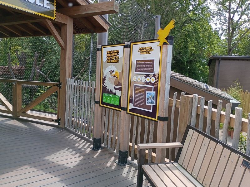
On West Powell Road (Ohio Route 750) at West Olentangy Street, on the right when traveling south on West Powell Road.
Bald eagles are at the top of the food chain, making them vulnerable to environmental toxins like DDT—a chemical once used to control insects. DDT entered waterways and was consumed by fish, a major food source for eagles. This caused eagles to . . . — — Map (db m309481) HM
On West Olentangy Street at West Powell Road ( Route 750), on the right when traveling east on West Olentangy Street.
Dr. Bernard F. Master served as a member of the Zoo's Appointed Board representing Franklin County from 2007 - 2022. Dr. Master is a distinguished health care professional and business entrepreneur who spent 36 years serving the inner-city low . . . — — Map (db m310369) HM
On West Olentangy Street at West Powell Road (Route 750), on the right when traveling east on West Olentangy Street.
With human settlement intensifying in the West during the early 1900s, large cattle operations and declining native prey populations caused many wolves to start preying on livestock. This led to focused efforts to eliminate the Mexican wolf from . . . — — Map (db m310368) HM
On Riverside Drive (Ohio Route 257) at Glick Road, on the right when traveling south on Riverside Drive.
Bonobos spend much of their time in the tree canopy, searching for food.
Bonobo Range Groups of bonobos are scattered throughout this incredibly small region.
Bonobos live in the Congo basin rainforest, the second largest tropical forest in . . . — — Map (db m310513) HM
On Columbus Pike (U.S. 23) at Hidden Ravines Drive, on the right when traveling south on Columbus Pike.
This memorial honors all American veterans who, although separated by generations, shared a common, undeniable goal-to valiantly protect our country's freedoms.
The memories of these American veterans will continue to live on whenever and . . . — — Map (db m297994) WM
On Columbus Pike (U.S. 23) at Hidden Ravines Drive, on the right when traveling south on Columbus Pike.
They told us, "We are going to have peace even if we have to fight for it." So we fought in the mountains on Heartbreak Ridge and waded ashore at Inchon.
We froze in the winter and baked in the summer sun.
At times, we were greatly . . . — — Map (db m297993) WM
On Columbus Pike (U.S. 23) at Hidden Ravines Drive, on the right when traveling south on Columbus Pike.
This Memorial is in honor of the men and woman who served to liberate the Iraqi people from the Regime of Saddam Hussain, Standing tall and supporting what our nation is all about, freedom.
The actions of those who were called to duty will . . . — — Map (db m297991) WM
On Columbus Pike (U.S. 23) at Hidden Ravines Drive, on the right when traveling south on Columbus Pike.
"I have seen in your eyes a fire of determination to get this job done quickly so that we may all return to the shores of our great nation. My confidence in you is total. Our cause is just! Now you must be the thunder and lightning of Desert . . . — — Map (db m297992) WM
On Columbus Pike (U.S. 23) at Hidden Ravines Drive, on the right when traveling south on Columbus Pike.
This memorial was erected in memory of the young individuals who went to war as kids and lost their youthful dreams, and some their lives, for a cause-freedom and honor-and came back as men with the horrors of war instilled in every fiber of . . . — — Map (db m297989) WM
On Columbus Pike (U.S. 23) at Hidden Ravines Drive, on the right when traveling south on Columbus Pike.
This memorial is in honor of all of the World War II veterans who were involved in the fight for the freedom of America and the free world.
Whether they fought in the Pacific or European theater, they faced a resolute and often brutal enemy; . . . — — Map (db m297988) WM
On Columbus Pike (U.S. 23) at Hidden Ravines Drive, on the right when traveling south on Columbus Pike.
August 27-29, 2004, Columbus, Ohio was blessed to have the Vietnam Wall Experience visit Kingwood Memorial Park. Over 500 volunteers helped keep the Wall open for 56 continuous hours. They braved the hot, humid, sticky days and nights to make . . . — — Map (db m297990) HM
On Riverside Drive (Ohio Route 257) at Glick Road, on the right when traveling south on Riverside Drive.
Devil Facial Tumor Disease
• This disease is a rare form of cancer characterized by large tumors around the mouth and head, eventually spreading to the rest of the body.
• As it is contagious between devils, it is the greatest . . . — — Map (db m310486) HM
On West Powell Road (Route 750) at West Olentangy Street, on the right when traveling south on West Powell Road.
Conservation:
Any threats are primarily human-caused habitat alteration - forestry and agricultural practices have caused massive destruction in the boreal forests of southern Canada.
While the IUCN lists moose as Least Concern on a . . . — — Map (db m309575) HM
Herman Mulzer’s saw mill and grist mill, seen in this circa 1900 photograph, sat on the west bank of the Olentangy River, across from the river from where you are now. The grist mill came into existence around 1817, and was operated by Mulzer from . . . — — Map (db m165526) HM
The grist mill and, at times, an accompanying saw mill were operated by a series of owners starting around 1817, but none more successfully than Herman Mulzer who operated the mill from 1977 until his death in 1906. In the later years, Herman’s son, . . . — — Map (db m165528) HM
On Riverside Drive (Ohio Route 257) north of Heathrow Drive.
This site marks the northern boundary of "The Kosciusko Lands." When General Kosciusko visited the United States in 1797, Congress appropriated over $15,000 to him and a land grant of 500 acres. This land was part of his reward and pay for services . . . — — Map (db m36754) HM
On West Powell Road (Route 750) at West Olentangy Street, on the right when traveling south on West Powell Road.
Ohio river otter populations are recovering, largely due to people working together to reintroduce the species and protect their habitats. By the mid-1950s, populations were eliminated through many parts of their range, including in Ohio. In the . . . — — Map (db m309480) HM
On Riverside Drive (Ohio Route 257) at Glick Road, on the right when traveling south on Riverside Drive.
Claudine André began helping orphaned bonobos in the early 1990s. In 1994, she founded Les Amis des Bonobos du Congo (Friends of Bonobos in Congo) to give others a way to help. This non-profit organization allowed her to gain the support needed to . . . — — Map (db m310515) HM
On West Powell Road (Ohio Route 750) at West Olentangy Street, on the right when traveling south on West Powell Road.
In 2004 these 2 Alaskan brown bears were orphaned outside Anchorage, Alaska. They stayed at the Alaska Zoo until the Columbus Zoo was able to arrange for their transport here to Columbus. Now they're real buckeyes! — — Map (db m309577) HM
The Union Land Company and the Case Family
Congress established the United States Military District in 1796 by an act to provide bounty land for Revolutionary War officers and soldiers. District lands consisted of 2.6 million acres in twelve . . . — — Map (db m12820) HM
On West Olentangy Street at West Powell Road ( Route 750), on the right when traveling east on West Olentangy Street.
Once found across North America, the trumpeter swan almost vanished because of hunting and habitat loss. By the 1930s, fewer than 100 remained south of Canada.
After being granted federal protection under the Migratory Bird Treaty Act, swan . . . — — Map (db m310370) HM
On Riverside Drive (Ohio Route 257) at Glick Road, on the right when traveling south on Riverside Drive.
Our 9/11 Bonobo
On September 11, 2001, an eight-year-old bonobo, Unga, along with another female, Kosana, left from a zoo in Belgium to fly across the Atlantic Ocean to Columbus, Ohio.
Change of flight plans
Late in their flight, the . . . — — Map (db m310511) HM
On Riverside Drive (Ohio Route 257) at Glick Road, on the right when traveling south on Riverside Drive.
Have You Heard?
Gibbons are considered one of the most agile animals on the planet.
They easily travel long distances through the thick forests swinging from tree to tree.
Habitat - mixed evergreen deciduous lowland forests . . . — — Map (db m310503) HM
On Riverside Drive (Ohio Route 257) at Glick Road, on the right when traveling south on Riverside Drive.
Have You Heard?
Gibbons are considered one of the most agile animals on the planet.
They easily travel long distances through the thick forests swinging from tree to tree.
Habitat - mixed evergreen deciduous lowland forests . . . — — Map (db m310505) HM
On Buckingham Place 0.2 miles north of Stafford Avenue.
On April 8, 1935, the United States Congress passed the Emergency Relief Appropriation Act. The Emergency Relief Appropriation Act was part of President Franklin Delano Roosevelt's New Deal. Roosevelt hoped that his New Deal would allow Americans . . . — — Map (db m271195) HM
Near Ohio Route 257 north of Glick Road, on the left when traveling north.
Although public concern has dramatically increased since the 1960s, the wild population of this species remains at risk. Research shows this is primarily due to years of human poaching and habitat destruction. — — Map (db m200901) HM
Near Ohio Route 257 north of Glick Road, on the left when traveling north.
Alligator
Alligator mississippiensis
• Water temperature determines eating activity: eating stops when temperature drops below 70°.
• Temperature of the nest determines sex of the young.
• Cooler . . . — — Map (db m200900) HM
Near West Powell Road (Route 750) east of Route 257, on the right when traveling west. Reported permanently removed.
1978: Listed for protection under the state and federal Endangered Species Act.
1979: Only 4 successful nesting pairs in the state.
1999: 50 nests recorded in the state.
2007: 164 nests were recorded with . . . — — Map (db m308911) HM
On West Powell Road (Ohio Route 750) east of Route 257, on the right when traveling west. Reported permanently removed.
Dr. Bernard Master joined the Zoo Board in 2007 representing Franklin County. Dr. Master is a distinguished health care professional and business entrepreneur who spent 36 years serving the inner-city low income and elderly population as a family . . . — — Map (db m308912) HM
On West Powell Road (Ohio Route 750) at West Olentangy Street, on the right when traveling south on West Powell Road.
The African lion population has declined by 90% in the last 75 years due to habitat loss and conflict with humans, primarily over loss of livestock. The Columbus Zoo and Aquarium supports EWASO Lions in conserving Kenya's lions and other large . . . — — Map (db m310353) HM
Near West Powell Road (Ohio Route 750) east of Route 257, on the right when traveling west. Reported permanently removed.
1900s
Victims of trapping, hunting and DDT poisoning, eagle numbers began to decline in the mid-to-late 1900s.
1978
The bald eagle was listed for protection under the Federal Endangered Species Act.
As a result of . . . — — Map (db m308910) HM
On West Powell Road (Route 750) at West Olentangy Street, on the right when traveling south on West Powell Road.
Over the past decade giraffe populations have been rapidly declining. Threats contributing to this decline include illegal hunting and habitat loss.
Could you survive on less than one hour of sleep a day? Giraffes . . . — — Map (db m310292) HM
On West Powell Road (Ohio Route 750) at West Olentangy Street, on the right when traveling south on West Powell Road.
There are several subspecies of giraffes in Africa. You can see two of those subspecies here at the Giraffe Shamba - Reticulated and Masai. Can you tell them apart?
Reticulated Giraffe
Reticulated giraffes are easy to spot. Look for . . . — — Map (db m310287) HM
Near Powell Road (Ohio Route 750) near Riverside Drive ( Route 257).
This "Grand Carousel," manufactured in 1914 by the William I. Mangels Company with wood horses carved by the Marcus Illions Company, was first located at Olentangy Park, an interurban-era amusement park in Clintonville. In 1938, the . . . — — Map (db m29942) HM
Near West Powell Road (Ohio Route 750) east of Route 257, on the right when traveling west.
Because so few trees grow on the prairies, pioneers often cut soil into blocks and used the blocks like bricks to build their houses. The soil was held together by the matted roots of prairie grasses. These soil houses were nicknamed "soddies" and . . . — — Map (db m200881) HM
Near West Powell Road (Ohio Route 750) east of Route 257, on the right when traveling west.
• Markhors can climb as high as 15'-20' in trees to eat the leaves.
• Hunted for meat. Horns are also valued as trophies and as ingredients in the Asian medicine trade.
• Loss of habitat due to expanded human settlement
• . . . — — Map (db m200897) HM
On West Powell Road (Ohio Route 750) east of Route 257, on the right when traveling west. Reported permanently removed.
💧 Lakes, rivers, streams
🏠 Hollow logs, rocky areas, abandoned beaver dens or dense vegetative areas used for dens
🏞️ Freshwater and coastal marine habitats, including rivers, lakes, marshes, swamps, . . . — — Map (db m308909) HM
Near Hall Street south of Powell Road ( Route 750), on the right when traveling east.
The Pledge of Allegiance
"I pledge allegiance to the Flag of the United States of America, and to the Republic for which it stands, one Nation under God, indivisible, with liberty and justice for all."
“Remembering those who defend . . . — — Map (db m215857) WM
Near West Powell Road (Ohio Route 750) east of Route 257, on the right when traveling west.
"Prairie" is the French word for meadow and French explorers used the word to describe the grasslands of the Mississippi Valley. Imagine this prairie sampler of native grasses and wildflowers stretching over 160,000,000 acres from Ohio to the . . . — — Map (db m200878) HM
Near West Powell Road (Ohio Route 750) east of Route 257, on the right when traveling west.
Common name: Black-Tailed Prairie Dog
Scientific name: Cynomys ludovicianus
Habitat and Distribution: grasslands of the Great Plains from northern Mexico to southern Colorado
Size: 14 to 17 inches . . . — — Map (db m200879) HM
Near West Powell Road (Ohio Route 750) east of Route 257, on the right when traveling west.
A Rare Bird
• Red-crowned cranes are the second rarest crane species after the whooping crane of North America-only 1700 remain.
• Red-crowned cranes mate for life.
Your Columbus Zoo and Aquarium supports . . . — — Map (db m200896) HM
Near West Powell Road (Ohio Route 750) east of Route 257, on the right when traveling west.
Since their near extinction in the 1970s, the Mexican wolf population is slowly recovering thanks to the collaborative efforts of many conservation organizations including the US Fish and Wildlife Service, the AZA Mexican Wolf Species Survival . . . — — Map (db m200875) HM
Near Ohio Route 257 north of Glick Road, on the left when traveling north.
The partnership between Dr. Lisa Dabek's Tree Kangaroo Conservation Project and local landowners in Papua, New Guinea provides a model of wildlife protection for the endangered Matschie's tree kangaroo. Since 1996, TKCP and local PNG people have . . . — — Map (db m200903) HM
Near West Powell Road (Route 750) east of Riverside Drive ( Route 257), on the left when traveling east. Reported permanently removed.
💧 In or near the water
🏠 Open water, reeds and cattails to escape predators
🏞️ Found in swamps, marshes, shallow ponds or lakes with abundant aquatic vegetation
🍴 Aquatic plants, seeds and . . . — — Map (db m308913) HM
On Riverside Drive (Ohio Route 257) at Glick Road, on the right when traveling south on Riverside Drive.
The Columbus Zoo contributes to conservation projects worldwide. Through the support of private donations, our Conservation Fund assists researchers in the African forest regions who study gorillas, bonobos, okapi, elephants, leopards and more. . . . — — Map (db m310517) HM
Near West Powell Road (Ohio Route 750) east of Route 257, on the right when traveling west.
Habitat Hollow
Step into an illustrated children's book and encounter animal greeters in their magical natural habitats. Learn what we can do to share the earth.
Wetlands Way
Animals use wetlands for food, water and shelter, in . . . — — Map (db m200876) HM
Near West Powell Road (Ohio Route 750) east of Route 257, on the right when traveling west.
Freshwater Mussels
Freshwater mussels…
…are bivalve mollusks dating back to the Triassic Period - more than 250 million years ago!
…are in trouble. Over 70% of mussel species are endangered and 37 are already extinct making . . . — — Map (db m200893) HM
Near Taylor Road at Main Street, on the left when traveling west.
At the west end of Taylor Street sits the Delhi (Radnor) School building. The school was originally a two story, two room brick structure built sometime between 1869 and 1874 with the stipulation that the upper room be used as the Town Hall. . . . — — Map (db m287714) HM
On Radnor Road at Route 203, on the right when traveling west on Radnor Road.
In honor of Radnor Area
Korean Veterans
Ralph Baker • Bryan Baxter • Harold Boehme • William Chaffins • Richard Coonfare • Richard Grandale • Dale Douglas • Donald Douglas • Lloyd Griffith • Carroll Harbin • Lowell Hetzner • Fred Hornsey • . . . — — Map (db m297983) WM
On Radnor Road (County Road 198) 0.1 miles east of State Route 203, on the right when traveling west.
Built in 1910, this lych gate was designed by local architect William Robert Powell to commemorate early settlers of Radnor who emigrated from Wales. Traditional in England and Wales, lych gates are covered gateways used to shelter coffins until . . . — — Map (db m26929) HM
On Meredith Road (County Route 191) at Lawrence Road (County Route 189), on the right when traveling north on Meredith Road.
Site of the
Radnor Presbyterian Log Church,
of the
Joint Delaware- Liberty- Radnor
Congregation
built 1819
Distinguished Sunday School Missionary
Benjamin W. Chidlaw
was a member of this church
1829- 1836
erected 1960 — — Map (db m89485) HM
On Ohio Route 203 south of John Street, on the left when traveling north.
Built in 1917, the Radnor School building was designed by local architect William R Powell. He supervised construction under the direction of school board members W.P. Penry (President), Rees Jones, Wm Jones, Walter Baxter and J.T. Lodwig. The . . . — — Map (db m203285) HM
On Radnor Road at Route 203, on the right when traveling west on Radnor Road.
In honor of Radnor Area
Veterans
who served our country.
American Revolutionary War
War of 1812
U.S. Civil War
Spanish-American War — — Map (db m297980) WM
On Radnor Road at Route 203, on the right when traveling west on Radnor Road.
In honor of Radnor Area
Vietnam Veterans
Jack Cook • Ted Coonfare • Kenny Fryman • Paul Fryman • Robert Fulton • Gary Good • Ronald Good • Donald Goodin • James Howald • Stephen Howe • Jeff Huffman • Rusty Jones • William Lamping
David . . . — — Map (db m297984) WM
On Radnor Road at Route 203, on the right when traveling west on Radnor Road.
In honor of Radnor Area
World War I Veterans
Thomas R. Griffith • Rossford Jones • Elmer Jones • Lysle Henry Reed • Charles L Reed • David Henry Thomas • James Garfield Thomas • Walter G. Penry — — Map (db m297981) WM
On Radnor Road at Route 203, on the right when traveling west on Radnor Road.
In memory of those
who served their country
in World War II
William Adams • Perry Baker • Frank Ball • Otis Bass • Carl Bill • Carl Berridge • Theodore Bish • John Bishop • Ernest Blue • Alfred Bogus • Frederick Bosh • Kenneth Boyd • Richard . . . — — Map (db m297982) WM
On Ohio Route 203 south of Taylor Street, on the right when traveling south.
The Delhi ME Church was one of five churches in Delhi. The building was completed in 1858 under the direction of Reverend Evan Roberts. The name changed twice first to the Radnor ME Church and in 1939 to Radnor Methodist Church. The building had . . . — — Map (db m256184) HM
On Taylor Street at Road 203, on the left when traveling west on Taylor Street.
The Radnor IOOF building was erected in 1854 and instituted as Radnor Lodge 250 on May 17, 1854. The upper level was the lodge hall with the lower level used as a general store and business. The IOOF missions were to visit the sick, relieve the . . . — — Map (db m221446) HM
On Ohio Route 203 at Taylor Street, on the right when traveling south on Ohio Route 203.
Morton House was erected by Thomas Morton Jr. in 1853 as his home and business. He operated a general store from May 1853 until his death on February 17, 1857. Following his death, the building was used as a home rental and general store. About . . . — — Map (db m247424) HM
On Ohio Route 203 at Radnor Road (County Road 198), on the right when traveling north on Ohio Route 203.
Powell General Store. Located on the NE corner of SR 203 and Radnor Rd, the Powell General Store was established by Welsh immigrants Robert and Ann Powell. They immigrated from Wales to Randnor in 1842 with their children John and Margaretta. . . . — — Map (db m287712) HM
On Radnor Road (County Road 198) at Baker Street, on the right when traveling east on Radnor Road.
The first religious society in Radnor Township was organized by Welsh Baptists on May 4, 1816. It consisted of 11 members who met in a log school where services were held in Welsh. In 1819, the first church, a hewed log meeting house, was built next . . . — — Map (db m237061) HM
On Ohio Route 203 south of Radnor Road (County Road 198), on the left when traveling north.
Originally called The The Welsh Calvinistic Congregational Bethel Church of Delhi, the name was shortened later to The Radnor Congregation Church and finally to its current name. Radnor Congregational United Church of Christ. The early church . . . — — Map (db m238287) HM
On Ohio Route 203 just south of Radnor Road (County Road 198), on the right when traveling south.
On this site in 1866, Hiram Beckley erected and used a building known as "Beckley Hall." In 1891 it was razed and a two-story brick structure replaced it. In 1894 the new structure was sold to the Radnor Township Trustees for use as the Radnor . . . — — Map (db m221593) HM
On Radnor Road (County Road 198) at State Route 203, on the right when traveling east on Radnor Road.
Radnor
Township Hall
has been placed on the
National Register
of Historic Places
in 2023
by the United States
Department of the Interior — — Map (db m247423) HM
On Radnor Road (County Road 198) east of State Route 203, on the right when traveling west.
Radnor village is located amid a cluster of elevated knolls surrounded by broad fields and beautiful farms largely devoted to the cultivation of grain. In the early 1800s, many Welsh settlers came to this country for three reasons: they wanted . . . — — Map (db m237062) HM
On Harriott Road (County Route 131) at Springdale Drive (County Route 1054), on the right when traveling east on Harriott Road.
Side A No one was more fiercely committed to the Underground Rail Road
than former slaves.They knew first-hand the darkness and despair
of bondage. Such was Abraham Depp (1791- 1858), known as Abram,
born a slave on a tobacco plantation . . . — — Map (db m108067) HM
On Harriott Road (County Route 131) at Frabell Drive (County Route 309), on the right when traveling east on Harriott Road.
Lucy Depp Park was a 102-acre development named for Lucinda Depp (1844-1929). She had inherited the land from her father, Abraham (1791-1858), an emancipated African American man and central Ohio pioneer from Powhattan County, Virginia. Known . . . — — Map (db m108066) HM
On Glick Road (Ohio Route 750) just west of Riverside Drive ( Route 257), on the right when traveling west.
Jeremiah Patrick O’Shaughnessy (1853-1921) began working for the City of Columbus in 1870 as a ditchdigger, digging the foundation for what was to be the new Columbus waterworks. He worked his way up to become superintendent of waterworks for . . . — — Map (db m310720) HM
On East Cherry Street (Ohio Route 37) at South Columbus Street, on the right when traveling west on East Cherry Street.
Major General William Starke Rosecrans
W.S. Rosecrans, soldier, engineer, architect and inventor, was born in Kingston Township in 1819. After graduation from West Point in 1842, he served in the Engineering Corps then taught at . . . — — Map (db m117341) HM
On Cherry Street (Ohio Route 37), on the left when traveling west.
In remembrance of those who have fallen in the War on Terrorism
The nation which forgets its defenders will itself be forgotten
Duty • Honor • Country
These heroes endured all
and gave all that justice
among nations might prevail
and . . . — — Map (db m19653) WM
On Granville Street at Columbus Street, on the left when traveling east on Granville Street.
Side A:
Sunbury, Ohio
“An Ohio Stagecoach Town from 1820-1873”
From its beginning in 1816, Sunbury was destined to be a stagecoach town. Anticipating large numbers of stagecoach travelers in Sunbury, the town's founder, Lawrence . . . — — Map (db m18304) HM
On West Cherry Street at Sunset Avenue, on the right when traveling east on West Cherry Street.
"We don't know them all, but we owe them all."
Dedicated to the memory of all who served and later died as a result of their service in the Global War on Terrorism.
We honor and remember their courage and . . . — — Map (db m297977) WM
On Hartford Road (County Road 44) east of Walnut Street, on the left when traveling east.
During World War II many professional baseball players were called to serve in the U.S. Military and many men’s teams were disbanded. This created a need for new professional baseball players and teams. To meet this need, the All American Girls . . . — — Map (db m309136) HM
On Hartford Road (County Road 44) east of Walnut Street, on the left when traveling east.
Billy Southworth was born on March 9, 1893 in Nebraska and grew up in Columbus OH. In 1940, Southworth settled on a farm along Big Walnut Creek in Trenton Township. During his major league baseball career, Southworth posted a winning percentage . . . — — Map (db m309201) HM
On Africa Road 0.2 miles south of Polaris Parkway, on the right when traveling north.
The Sharp family homes and their locations on N. State Street and Africa Road mark an important route through Westerville on the Underground Railroad. The family patriarch, Garrit Sharp, was an original settler of Sharp's Settlement, now . . . — — Map (db m171804) HM
On East Broad Street (Ohio Route 16) at South Stanwood Road, on the right when traveling east on East Broad Street.
The spirit is not dead
Proclaim the word,
Where lay dead bones,
A host of armed
Men stand!
Hope your graves,
My people,
Saith the Lord,
And I shall place you
Living in your land.
Emma . . . — — Map (db m201228) HM WM
The graffiti you see here was written by people whose lives were directly affected by The Wall. Now that The Wall is history, we ask that you leave
it just the way it is.
The one side of The Wall is empty of graffiti because it faced the . . . — — Map (db m276749) HM
On Main Street (U.S. 40) at Cassady Avenue, on the right when traveling east on Main Street.
The National Road
To George Washington, Thomas Jefferson and others, a road to the Ohio Country was essential for the United States’ development. An overland route was the way west for settlers and goods, as well as a means to transport . . . — — Map (db m15785) HM
On Broad Street (U.S. 40) at Drexel Avenue, on the right when traveling west on Broad Street.
Named after Bexley County of Kent, England. “Bullitt Park” in this “refugee tract” became a residential section in April 1891.
The Village of Bexley was incorporated June 13, 1908, and the first Council met August 10. A . . . — — Map (db m20510) HM
On Broad Street (U.S. 40) at Drexel Avenue, on the right when traveling west on Broad Street.
Bexley will ever remember her men and women who served in the Armed Forces of the U.S.A. during the Second World War
Names of Bexley's World War II veterans are engraved around the monument. — — Map (db m16921) WM
On Broad Street (U.S. 40) at Drexel Avenue, on the right when traveling west on Broad Street.
To establish a camp of general rendezvous for the Ohio National Guard and other Ohio troops, the citizens of Columbus offered to the State of Ohio Bullitt Park, now a part of Bexley - President William McKinley, April 25 1898, through Governor Asa . . . — — Map (db m16931) HM
On Pleasant Ridge Avenue at Main Street (U.S. 40), on the left when traveling north on Pleasant Ridge Avenue.
Founded in 1830 as a Lutheran Seminary and chartered as a University in 1850, Capital University offers diverse undergraduate and graduate programs in the arts, sciences and professional studies.
Ethical, moral and religious values essential to . . . — — Map (db m15784) HM
On East Main Street (U.S. 40) at South Drexel Avenue (U.S. 40), on the right when traveling west on East Main Street.
The Drexel Theatre is a significant example of the once-ubiquitous small neighborhood theatres that appeared in the 1930s, a time when movies were an inexpensive and popular form of entertainment. Designed by architect Robert R. Royce, the theatre . . . — — Map (db m114455) HM
Near North Parkview Avenue at Commonwealth Park South, on the left when traveling north.
The Jeffrey Mansion was built in 1905 by the Robert H. Jeffrey family. Designed by Columbus architect Frank Packard in the Jacobethan Revival style, the mansion and 35 acre grounds reflect a tradition of English influence.
Located at the end . . . — — Map (db m201226) HM
On Waterloo Street west of Trine Street, on the left when traveling west.
The Canal Winchester Art Guild's
Mural Project 2024 Presents
"Ohio Barn"
by Pamela Montgomery
A self-taught watercolor artist, Pamela creatively displays life as it once was. Her primary subject matter
depicts historical . . . — — Map (db m303079) HM