The treaty Lewis Cass accomplished in 1820, cleared the way for the U.S. Army to install a post at the Sault. Consequently, Secretary of War John C. Calhoun ordered a battalion of the 2nd U.S. Infantry, composed of 250 men and 17 officers, commanded . . . — — Map (db m214149) HM
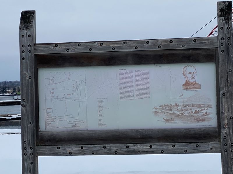
On July 6, 1822, a battalion of American troops under Col. Hugh Brady reached the Sault, thereby reconfirming the assertion of American authority over this region made by Lewis Cass in 1820. Fort Brady was built here by year's end. The French and . . . — — Map (db m213413) HM
American troops arrived in Sault Ste. Marie in the summer of 1822 to establish a fort by provision of the Treaty Lewis Cass signed here in 1820. The fort signaled the end of the long French and British occupation of the territory. The fort was . . . — — Map (db m214151) HM
Chase S. Osborn was a man whose lifetime presents an extraordinary legacy of activities and accomplishments. He served as Governor of Michigan during 1911-1912, the only man from the Upper Peninsula to do so in the State's first 150 years. Author, . . . — — Map (db m224369) HM
In 1845, the Independence became the first steam vessel on Lake Superior.
Arriving below the falls in 1845, the 105 foot long vessel was hauled out of the water and portaged nearly a mile around the falls and re-launched above the rapids.
The . . . — — Map (db m214167) HM
When American troops arrived in 1822 to establish a fort, the soldiers built a mill race, which ran from above the rapids to a mill located near the present Osborn-Portage intersection, with the water returning to the river at approximately this . . . — — Map (db m306221) HM
This water tower was constructed in 1894 with a base of native sandstone that supports a brick top section covering a 364,000 gallon steel tank. As a vital component of the water system of the City of Sault St.e Marie, this community landmark was . . . — — Map (db m213456) HM
Built in 1899 this building housed the local office of the Weather Bureau. From here, they monitored conditions, made forecasts and hand delivered weather reports to passing vessels.
Ship-to-shore radio made it less important to have a . . . — — Map (db m214170) HM
The row houses were built between 1900-1903 to house commissioned officers and their families when the Lake Superior State University campus was still serving as US Army Fort Brady. Over the years, the buildings have housed campus faculty, staff and . . . — — Map (db m214234) HM
The maritime professionals who sail the ships on the Great Lakes are celebrating the 100th anniversary of their fraternal organization, the I. M. S. A. whose purpose is stated in the Association's constitution, “The purpose of this association’s . . . — — Map (db m214171) HM
James Norris, a great supporter of hockey, is regarded as one of the founders of the modern game. Canadian born, he moved to the United States around the turn of the century. Though an extremely successful businessman, he always practiced his love . . . — — Map (db m214252) HM
Former home and trading post
of the
John Johnston Family
second oldest building in the northwest
built in 1795 - 96
Here in 1824,
Henry Rowe Schoolcraft, historian
married Jane,
daughter of Johnston
and his O'Jibway Indian . . . — — Map (db m213416) HM
A native of Ireland and a Protestant, John Johnston (1762-1828) arrived on the Lake Superior frontier in the early 1790s. He married the daughter of a powerful Chippewa chief and settled here in 1793. Johnston's knowledge of the Chippewa and the . . . — — Map (db m213414) HM
In 1946 the State of Michigan assumed control of New Fort Brady, and presented it to the Michigan College of Mining and Technology, now Michigan Technological University. The Houghton based school, forced to expand by the enrollment of returning . . . — — Map (db m213421) HM
The row houses were built between 1900-1903 to house commissioned officers and their families when the Lake Superior State University campus was still serving as US Army Fort Brady. Over the years, the buildings have housed campus faculty, staff and . . . — — Map (db m214239) HM
Until 1962 Three Mile (Larke)
Road was known simply as
Larke Road. In 1876 Henry
Larke (1824-1900) became
the first settler along this
road, making his home about
one and one-half miles
west of this site. He had emigrated from Canada, . . . — — Map (db m253763) HM
This Shinto Torii, presented by Chase S. Osborn in 1905, was one of his many gifts meant to bring a bit of the outside world to Sault Ste. Marie.
In Japan, the Torii serves as a formal gate marking the entrance to special or sacred places. . . . — — Map (db m213654) HM
Several Methodist ministers were active in missionary work in the "Soo" area in the 1830s. John Sunday, an Indian preacher from Canada, began mission work in the Indian settlement at the Sault Ste. Marie Rapids around 1831. The Reverend John . . . — — Map (db m213422) HM
On August 25, 1840, United States Deputy Surveyor, Wm. A. Burt, established at this point the north end of the principal meridian from which all land in Michigan is surveyed. — — Map (db m198456) HM
When Sault Ste. Marie expanded and its canal was widened, the riverfront site of Fort Brady was abandoned for a higher, more strategic site selected by General Philip Sheridan. Work began in 1886, and the new fort was opened in 1893. From this . . . — — Map (db m213444) HM
On this site Old Fort Brady
First U.S. Army post in Michigan's upper peninsula was established in 1822
Colonel Hugh Brady, Second U.S. Infantry Commanding — — Map (db m214163) HM
The row houses were built between 1900-1903 to house commissioned officers and their families when the Lake Superior State University campus was still serving as US Army Fort Brady. Over the years, the buildings have housed campus faculty, staff and . . . — — Map (db m214231) HM
Walk along Water Street and you will cross the stage where many of the events of Sault Ste. Marie's early history played out.
Our interpretive panels along the way will help you understand the important role the St. Marys River played in our . . . — — Map (db m214853) HM
The Marquette was owned and operated by the U.S. Army Corps of Engineers. Her home port was Duluth, Minnesota. The Marquette was built in 1942 by Equitable Equipment Co. at New Orleans, Louisiana. She measured 103 feet long, 26 feet wide, and 11 . . . — — Map (db m214169) HM
1900-1903 to house commissioned officers
and their families when the Lake Superior
State University campus was still serving
as US Army Fort Brady. Over the years,
the buildings have housed campus faculty,
staff and students, and have served . . . — — Map (db m213632) HM
This city, the oldest in the Midwest, grew up about the mission of Fathers Dablon and Marquette, founded in 1668 on the banks of the rapids through which Lake Superior’s waters commence their long journey seaward. In 1641 Fathers Jogues and . . . — — Map (db m213446) HM
The adjacent building
is the Sault Ste. Marie Indian Agency
built in 1827 by
Henry Rowe Schoolcraft
Author, historian and foremost
authority on American Indian
life, manners and customs.
Here Schoolcraft wrote some of the
books . . . — — Map (db m192400) HM
On this site in 1822-23 a water power Saw Mill the first power manufacturing plant in the north country was built by Fort Brady personnel — — Map (db m214166) HM
On this site in 1668 was built the first permanent wooden structure in what is now the state of Michigan. This was St. Mary's Church erected by the French Jesuit fathers Jacques Marquette and Louis Nicholas to minister to the Ojibwe community. The . . . — — Map (db m214153) HM
St. Marys Falls Canal has been designated a Registered National Historic Landmark Under the provisions of the Historic Sites Act of August 21, 1935 this site possesses exceptional value in commemorating or illustrating the history of the . . . — — Map (db m143700) HM
In 1853, Pope Pius IX separated the Upper Peninsula from the Diocese of Detroit and established a vicariate apostolic. Reverend Frederic Baraga, a missionary from L’Anse, became vicar apostolic and made St. Mary’s Church his headquarters. In 1857 . . . — — Map (db m213449) HM
This statue of St. Mary is placed in this location to reflect the namesake of the St. Marys River and the twin cities of Sault Ste. Marie. It was originally located in the Sisters of Charity Hospital in Detroit for many years and moved to this . . . — — Map (db m214162) HM
This historic three ton anchor was donated to the college in 1969, by the Alumni Association. The anchor came from the V.H. Ketcham, a wooden iron ore freighter, the first vessel operated by Pickings Mather & Co. It was a pioneer, being the first . . . — — Map (db m213462) HM
Though unpretentious, the Elijah B. Allen House at 126 Water Street has nonetheless been significant in Sault and regional history. Built around 1822, it is probably the second oldest house in Sault Ste. Marie after the Johnston House. It was here . . . — — Map (db m214161) HM
To provide a refuge at Sault Ste. Marie for French traders and missionaries, King Louis XV in 1750 ordered Louis de Repentigny to build a fort near what later became Fort Brady. The king also granted 214,000 surrounding acres of land to de . . . — — Map (db m214148) HM
A thick layer of stone holds back the waters of Laker Superior and creates rapids here where the waters of Lake Superior drop 21 feet at the head of the St. Marys River.
Without this layer of stone between Lake Superior and the St. Marys . . . — — Map (db m224367) HM
Erected by the citizenry of Chippewa County in appreciation of the services of their war heroes.
Civil War 1861-1865; Spanish American War 1898-1902; World War 1917-1918 — — Map (db m92742) WM
By the late 1880s, business was booming on Water Street. Railroad lines had come, a water power plant had been constructed at the rapids, and a second lock had been built. Sault Ste. Marie was incorporated as a city in 1887.
After a fire . . . — — Map (db m214159) HM
Indians of early copper culture occupied the Bays de Noc over 5,000 years ago. We know when French explorers came to this area, they were greeted by members of the Noke tribe. The Nokes territory extended from north Green Bay and the Bays de Noc . . . — — Map (db m137243) HM
Charles Brotherton
In 1852 Charles Brotherton came to the Upper Peninsula with a survey team organized by William Burt. Two years later, Peter White hired him to survey the land between the Menominee River and Marquette. His work in the . . . — — Map (db m139050) HM
Escanaba: The Port
It was the abundant timber that first lured settlers to the area to start sawmill communities along rivers flowing into the bay. Although Escanaba itself was not heavily wooded, as a port it became a commercial hub for . . . — — Map (db m137157) HM
At your immediate left, the first dock you see is the decaying Chicago and Northwestern Railway Dock, locally called the Merchant's Dock. Most of Escanaba's freight and passengers to and from the South and East came and went over this dock before . . . — — Map (db m137161) HM
This tablet marks
the site of the first
public schoolhouse
erected in Escanaba.
1867
Placed by Lewis Cass Chapter
Daughters of the American Revolution
1934 — — Map (db m139082) HM
Beginning with the Native Americans to present day, people have found food, fortune and failure fishing the Bays de Noc. In 1866, commercial fishing at Escanaba began with catching fish for visiting trade vessels and local logging camps. In the . . . — — Map (db m137306) HM
From this port, beginning in 1864
and ending with the Ore Centennial
Year 1964, more than 340,000,000
tons of iron ore were shipped.
The Chicago and North Western
Railway Company, iron ore-handlers
for 100 years, built the big dock . . . — — Map (db m137259) HM
The Noquet (or Noc) Indians, who once lived along these shores, gave this bay its name. Here at Sand Point, in 1844, Douglass Houghton came with his party of government surveyors to chart the land to the north. In 1864 the first ore dock was built . . . — — Map (db m137285) HM
In 1864, E. Gaynor built the Gaynor House hotel, which he renamed Ludington House in 1871. after lumberman Nelson Ludington. In the late 1800s proprietor John Christie enlarged the hotel and renamed the establishment the New Ludington Hotel. An . . . — — Map (db m135301) HM
Sand Point Lighthouse
From 1868 to 1939 the Sand Point Lighthouse warned mariners of the spit of land extending into Little Bay de Noc at the entrance to Escanaba Harbor. The U.S. Congress authorized construction of the lighthouse in 1864, . . . — — Map (db m137333) HM
Escanaba has a long history in timber and fishing, but it is the perfect natural harbor and closeness to the iron range that have given Escanaba prominence in Michigan history. During the 1800's through the 1950's, large chunks of low grade ore . . . — — Map (db m137260) HM
Starting in 1861, the Civil War tore apart the nation and resulted in the immediate need of iron ore to provide weapons for the North. William B. Ogden, an owner of the Chicago & Northwest Railroad Co., knew of the plentiful iron mines of the . . . — — Map (db m137258) HM
Possessed of both a deep channel and protection by the natural break waters of Sand Point, Escanaba has a top rated natural harbor. Since Escanaba's beginning, the timber trade shipped from this harbor, and the Lake Schooners Fleet dominated the . . . — — Map (db m137290) HM
The growth of Escanaba from a small town into a growing city in such a brief time can be traced directly to the expansion of lake shipping in this port. Over the years, Escanaba harbor has seen times of boom and bust in the fishing, lumber and . . . — — Map (db m137286) HM
Escanaba River: The Legend
This is the land of the Chippewa Indians and the legendary Hiawatha. Indian villages existed along the banks of the river, and Indians were living here when the first white men came to this region in the 1600's. . . . — — Map (db m139220) HM
The main street, Stewart Avenue, is located through a beautiful little grove and the houses so encircled by trees as to be invisible until one is close beside them. Escanaba Tribune 1870
The middle class families of Fayette's foremen, . . . — — Map (db m128861) HM
Single employees found room and board at the hotel or in boarding houses like the one located here. In 1880, almost half the men at Fayette were boarders.
Many residents, like Annette and John DeVet, took in boarders to supplement their income. . . . — — Map (db m128862) HM
A carpenter crew maintained Fayette's buildings. The carpenters also built and repaired wagons, carts and railroad cars and made doors, window sashes and coffins. Milled lumber was stocked in adjacent sheds.
A large woodshop, built here in . . . — — Map (db m128866) HM
Fears were entertained that the supply of charcoal would fall short, but with extraordinary exertions, they now have another set of kilns ready, and the supply will be kept up. Escanaba Tribune 1870
Colliers manufactured charcoal to fuel . . . — — Map (db m128860) HM
The location has… two streets circling around the little bay, upon which have been erected some ten or twelve neat frame buildings. There are also some twenty-five or thirty log shanties, all occupied, but they are on the opposite slope from the . . . — — Map (db m128853) HM
Our five o'clock whistle [is] the most tedious noise ever made. Escanaba Tribune 1872
The furnace complex was the heart of industrial Fayette. Here, the heat, roar and odors of the smelting operation merged with the shouts of men, whir of . . . — — Map (db m128852) HM
The rooms on this upper level of the furnace complex housed the machinery which powered the foundry's hot blast. Boilers supplied steam to blowing engines which forced air through the hot blast ovens and into the furnaces.
The furnace stacks . . . — — Map (db m128856) HM
Machinists like Louis Follo maintained Fayette’s industrial equipment from this shop.
Power machinery, used to manufacture equipment parts, was driven by steam piped from the furnace boilers.
Master mechanics were paid $75 per month. . . . — — Map (db m128867) HM
Loaded at the top with thirty-five cords of hardwood, each kiln produced some 1,750 bushels of charcoal per burning.
The charring process lasted six to eight days. When cool, the charcoal was removed by hand at the lower door.
Source: . . . — — Map (db m128857) HM
A couple of cars loaded with lumber broke loose at the top of the Mud Lake grade and ran into some coal cars at its foot with sad results to all. Escanaba Iron Port 1882
By 1872, the Jackson Iron Company had built a six-mile railroad . . . — — Map (db m128855) HM
The sawmill is again "in blast," and is doing good work as it always does. Escanaba Tribune 1870
Fayette’s sawmill burned in 1871 and was rebuilt the following year. In its basement shops carpenters assembled wagons and . . . — — Map (db m128865) HM
Iron ore was crushed, mixed with measured amounts of charcoal and limestone, and lifted by a steam-powered hoist to the top of the furnace where it was dropped into the stack.
Inside the furnace the charcoal burned, fed by forced air heated in . . . — — Map (db m128859) HM
Fayette looks like a little Chicago this week; the harbor is full of boats and business is brisk. Schoolcraft County Pioneer 1881
Four warehouses stood on a wharf off this point of land. Vessels like the steam barge Fayette . . . — — Map (db m128864) HM
There has been a water pipe laid from the furnace through the streets as far as the barn, so that water can be had in case of fire at a hydrant near the store. Escanaba Tribune 1871
This underground pipeline supplied potable water to the . . . — — Map (db m128858) HM
This building has always been teeming with life and energy. Built in 1923 by the Northwestern Cooperage and Lumber Company as a Community Center. The excavation was done by Robert Nebal and foundation by Ole Peterson. The Grand Opening was held . . . — — Map (db m288015) HM
This beautiful building was built in 1888 at the corner of 6th St. and Delta Avenue. It was called the Hassell Inn. The Exchange Bank was located on the lower left side of the building until it was moved to 810 Delta Avenue and became the . . . — — Map (db m288022) HM
In 1934 the U.S. Government purchased this property to build the New Gladstone Post Office. The Architect was Louis Simon, the Engineer was George O Van Nerta. The General Contractors were Victor and John Jacobson from Duluth Minnesota. There were . . . — — Map (db m285744) HM
Established in the early 1940's, this building housed the first full service medical clinic in the County. Built by Dr. Otto Hult who practiced medicine for 46 years. Otto Hult was born in Gladstone on Sept. 4th, 1901. He grew up in the Buckeye . . . — — Map (db m288020) HM
This building is quaint and small with a big heart. Rev. George C. Empson came to Gladstone in 1890 from England, to establish the First Congregational Church. He purchased this site and built this church in 1900. The parsonage was located at . . . — — Map (db m298239) HM
The Pacific House was built by James J Miller in 1888. Mr. Miller was the first President of the Village and the first Mayor of the new City of Gladstone. Mr. Miller also built the first grocery store and meat market in the city. When James . . . — — Map (db m288019) HM
Kjellander and Sons Blacksmith Shop
The blacksmith shop was always one of the first businesses established in a community.
Swan Kjellander arrived in Gladstone in 1896 and went to work at the Soo Line Dock as a blacksmith. Four years . . . — — Map (db m288058) HM
This beautiful Neo-Classical Art Deco building was part of the Public Works Project #232, initiated during the Great Depression of the 1930's. Groundbreaking took place on May 5th, 1935. It was called the New Fireproof City Hall. It included a . . . — — Map (db m286288) HM
This beautiful home was built in 1894 by local contractor, Nels Gormsen, for Samuel Goldstein who came to Gladstone in 1889. Goldstein established a Dry Goods store at 801 Delta Avenue and operated the store for 24 years. Mr. Goldstein was born . . . — — Map (db m298240) HM
“The Finest Bath House on the Finest Beach"
During the Great Depression, the Gladstone City Club saw an opportunity for funding through President Roosevelt's New Deal and made the recommendation to the City Council and Mayor Alfred Raddent, to . . . — — Map (db m285737) HM
This beautiful Colonial Revival single family home was built in 1900. The design was simple, symmetrical and practical. This style home is one of the more enduring examples of American Architecture.
J Paul Bushong owned this home. Paul came . . . — — Map (db m298292) HM
This traditional family home brings style and comfort to the neighborhood. Built in 1927 for one of the city's oldest residents. William L. Marble. He came to Gladstone at the age of seven the first son of Webster Marble, founder of Marble . . . — — Map (db m298319) HM
This magnificent church was formally dedicated June 12th, 1922. The former All Saints Catholic Church burned to the ground on March 5th, 1920. From that devastation, this beautiful edifice was constructed.
The community gathered to rebuild . . . — — Map (db m285705) HM
Thomas O'Connell was born December 21st, 1844, in Dungarvan, County Waterford Ireland. He married Mary Flynn and they immigrated to New York in the early 1860's. Thomas then traveled to Green Bay to work for the Chicago Northwestern Railroad. . . . — — Map (db m288035) HM
Known as one of the most prosperous businesses in the city, Goldstein's Dry Goods. Samual Goldstein was born in Russia in August of 1854. He married Dorothy Jacobson, and they had four children. Sam arrived in Gladstone in 1889 and established . . . — — Map (db m288034) HM
This beautiful Georgian Style home was built in 1927 for James T. Jones. Jones arrived in Gladstone in 1905 at the age of 20 to work specifically for Webster L. Marble and the Marble Axe Company. By 1910 he was the assistant manager and within . . . — — Map (db m298337) HM
This beautiful home style was very popular when built in 1905 for one of the City's wealthiest industrialists. Issac [sic] N. Bushong was born in Ohio in 1855. He came from a very humble beginning to developing holdings in Ohio, . . . — — Map (db m298283) HM
The first bank to be established in Gladstone was in the Hotel Delta located at the corner of 6th street and Delta Ave. The year was 1887 and it was called the Marble & Foss Bank. By 1890 the name was changed to The Exchange Bank of Gladstone.
. . . — — Map (db m288050) HM
Erick Segersten immigrated from Sweden in 1890 and settled in Gladstone in 1895. He purchased property on Dakota Avenue and built a home where he and his wife Ida (Benson) raised six children. Mr. Segersten worked as a blacksmith in the Buckeye . . . — — Map (db m288054) HM
Star Grocery was the longest serving grocery store in Gladstone. Swan Nelson built Star Grocery as one of the first grocery stores in the city. Mr. Nelson came to Gladstone in 1895. He and his family lived above the store until he built a . . . — — Map (db m288048) HM
This charming family home is functional and practical and suited the personality of Webster L. Marble in 1900. Webster Marble was one of the greatest inventors and entrepreneurs of his time. He designed and developed practical, useful outdoor . . . — — Map (db m298343) HM
One of the most trusted and respected early merchants in Gladstone was Henry Rosenblum. Mr. Rosenblum immigrated from Kiev Russia-Poland and settled in Gladstone in 1891. He and his wife Rose opened their first store in the 900 block on Delta . . . — — Map (db m288044) HM
The unassuming two-story garage behind this charming home is the original 640 sq ft building, "Where it all Began." Webster Marble made 19 Folding Safety Axes for friends in this location and designed the first of many Gun Sites.
"Webster . . . — — Map (db m298346) HM
This location housed the Gladstone Grocery Company established by Peter Lindblad. Mr. Lindblad was born in Soderham Sweden in 1869. He was 22 years old when he arrived in Gladstone. He married Christina Hagland from Escanaba in 1891 and they had . . . — — Map (db m285740) HM
This quaint family home once belonged to the Floyd Marble family. Floyd was the youngest son of Webster Marble. Born on June 20th, 1891, in Gladstone. His first job was as cashier of the Gladstone State Savings Bank, but he was also deeply . . . — — Map (db m298349) HM
One of the most popular stores in Gladstone that operated for almost 55 years was Rouman's Candy Kitchen.
Brothers Leo and Jim Rouman immigrated from Katavothra Greece to Gladstone in 1903. They came from a family of eleven children and . . . — — Map (db m288032) HM
Gustof Edward Dehlin was born in 1889 in Vastergotland Sweden and immigrated to the America in 1893. He graduated from Pharmaceutical School in 1913 and lived in Manistique and worked for a local druggist.
He married Joan (Josie) Barrett from . . . — — Map (db m286301) HM
August 14th, 1916, The First National Bank was organized and received its charter from FDIC. Original officers were President H.B. Laing, Vice Pres. Frederick Huber, directors Michael Gleason, A.E. Neff, Adam Schaible, J.J. Cleary and E.J. . . . — — Map (db m288030) HM
This great building was built in 1909, but it wasn't the first structure to sit in this location. Richard Mason and Charles Scott built the first building in the city, and it was called the Minnewaska Hotel. It was located at the corner of 3rd. . . . — — Map (db m288055) HM
The Trinity Episcopal Church is a diverse, all-inclusive community of Faith and everyone is welcome.
“The Little Brown Church" is one of the oldest church buildings still in use in Gladstone.
Designed by Thomas Nobel, it was built in 1900. . . . — — Map (db m285699) HM
One of the older buildings in the city was one of the first Saloons. Soren Johnson born in Nordland Norway in 1867, made his way to Gladstone in 1890. He opened a "Sample Room" at 729 Delta Ave, then moved to this location. As one of the first . . . — — Map (db m285794) HM
Built in the early 1900's this building has been home to a variety of businesses. Samual Rosenblum had immigrated from Russia/Poland in the late 1800's and settled in Gladstone. He opened The Boot Shop in the building on the corner. He later . . . — — Map (db m287978) HM
556 entries matched your criteria. Entries 101 through 200 are listed above. ⊲ Previous 100 — Next 100 ⊳