Escalante's first church stood on or near this spot. It was a two-story building made of white sandstone. The upper floor was used as the LDS Chapel and for recreational purposes; the lower floor provided classrooms for church organizations and at . . . — — Map (db m74748) HM
The Last Frontier ”No animal without wings could cross the deep gulches in the sandstone basin at our feet. The stream which we had followed and whose course soon became lost in the multitude of chasms before us was not the one we were . . . — — Map (db m146681) HM
About 1872 Joseph Asay with his family settled about 3/4 mile west and a little south of this spot. Soon other homesteaders settled in the locality. Tom Jessup and Dan LeRoy erected a water power saw mill. A shingle mill was also placed on the . . . — — Map (db m74676) HM
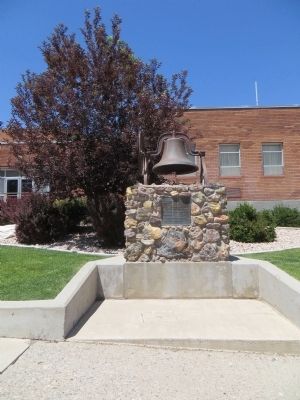
In 1904 the Hatch L.D.S. Ward building was erected on this lot. A vestibule was added in 1910 and the bell was purchased with donations from ward members. For many years it hung in the tower and rang out for all civic, social and church activities. . . . — — Map (db m74679) HM
In 1872 Meltiar Hatch settled at the head of the Sevier River, near the junction of Mammoth and Asay Creeks. He engaged in stock raising and operated a water-power saw mill. Soon other settlers came. Land was surveyed and irrigation ditches dug. . . . — — Map (db m74677) HM
Dakota Formation’s Coal and Clay While the rock formations in this region often presented formidable travel obstacles for early settlers, they also supplied many useful natural resources. Locally, a rock layer known as the Dakota Formation (the . . . — — Map (db m146737) HM
In 1871, this region was part of the last uncharted territory in the continental United States. That year, Major John Wesley Powell launched the Second Powell Expedition to explore and map this frontier, continuing the work he had begun three years . . . — — Map (db m74763) HM
Sheep by the Thousands ”I'd imagine there'd be 100,000 sheep sheared down there... I think they had about twenty sheep shearers — good, fast sheep shearers — and they was going all the time there..." —Jim Smith of . . . — — Map (db m146720) HM
Visitors to Panguitch, Utah will enjoy the opportunity to view many of the historic structures in this community which was settled by Mormon pioneers.
Famously creative survival skills are not the only heritage the early settlers left behind. . . . — — Map (db m146764) HM
Outlaw or Hero?
"My father, he carried the mail, and he always stopped and had dinner at a certain place [in Red Canyon]. While he was having dinner, old Butch Cassidy came to his camp. He told about these fellows following him. He got up . . . — — Map (db m40513) HM
In March, 1864, about fifty pioneers under the leadership of Jens Nielson settled Panguitch. They built a fort of logs, enclosing their homes and a building used for church, school and recreation. The town was abandoned in 1867, because of Indian . . . — — Map (db m27020) HM
Panguitch stake of the L.D.S. Church was organized in 1877 with James Henrie as president. In March 1880, plans were made for a stake house with George Dodds, architect, and M.M. Steel, Sr., chairman of the building. The following men were prominent . . . — — Map (db m27040) HM
During the first settlement of Panguitch, between 1864 and 1867, members of The Church of Jesus Christ of Latter-day Saints paid tithes with produce and cattle, which were kept on this lot and disbursed as needed. Barns and corrals were constructed . . . — — Map (db m74680) HM
Podunk received its name from a Paiute Indian named Po Dunk, who had become lost in the heavily timbered area near the East Fork of the Sevier River. The area was named after him, and the guard station named after the area in which it was built and . . . — — Map (db m40482) HM
A New Park's Magical Opening
"One little fairy hopped upon the running board and asked Governor Dern if he believed in fairies. 'Yes,' he said. 'Then,' said she, 'enter into Fairyland." - From Golden Nuggets of Pioneer Days, Daughters . . . — — Map (db m40509) HM
The Panguitch Social Hall was built during the years between 1890-1900. Fredrick Judd made the bricks and slacked the lime for the laying of the brick. The walls were three bricks thick, and the building had wide double-doors on either side of the . . . — — Map (db m74682) HM
The first group of pioneers came to Panguitch on March 16, 1864, from Parowan under the leadership of Jens Nielson. They followed the route over the rugged Bear Valley, a part of the Spanish Trail. Crops were planted, but the season was short and . . . — — Map (db m27046) HM
In 1864 a group of hardy pioneers braved the mountain snows to save their families from starvation. This group of men encountered snows that were impassable. According to their
faith they knelt on a quilt in a prayer circle. The answer to their . . . — — Map (db m74681) HM
Clifton (Loseeville) was situated in East Valley one mile east of the Pahreah River and four miles North of Cannonville. The first settlers were Ebenezer Bryce in 1876 and Daniel Goulding in 1878. They built a ditch to bring water to the valley from . . . — — Map (db m74743) HM
This vast area was once covered by extensive sand dunes. Some 200 million years ago, winds from the northwest carried tons of fine-grained sand into this area, creating an immense desert.
Over time, the sand drifts were covered by other layers of . . . — — Map (db m160002) HM
The forces of erosion are sculpting more than just arches. Balanced Rock clearly shows the various layers responsible for this amazing defiance of gravity.
The caprock of the hard Slick Rock Member of the Entrada Sandstone is perched upon a . . . — — Map (db m52002) HM
The third largest arch in the park, Double Arch's larger span is 144 feet wide by 112 feet high (44 by 34 meters). The smaller opening is 67 feet wide by 86 feet high (20 by 26 meters).
For a closer look at Double Arch, walk this easy trail . . . — — Map (db m131861) HM
Height: flower stalk 1'-3'
Flower: greenish-yellow to cream
Bloom: spring
Each yucca species is pollinated only by one specific yucca moth; neither could survive without the other. A yucca blooms most years, with showy, bell-like . . . — — Map (db m159954) HM
In the Windows area, you can see many stages of arch formation. Look closely. Some arches are hard to see because of rock walls behind them.
Entrada Sandstone — the rocks in which arches are formed — was deposited here as sand more . . . — — Map (db m160003) HM
Height: 2'-7'
Flower: small, in showy yellow clusters
Bloom: late summer-autumn
This common shrub has green photosynthetic stems. In autumn, it is covered by gold blooms. The flowers provide a late-season source of nectar for . . . — — Map (db m159955) HM
John Wesley Wolfe settled here in the late 1800s with his oldest son Fred. A nagging leg injury from the Civil War prompted John to move west from Ohio, looking for a drier climate. He chose this tract of more than 100 acres along Salt Wash for . . . — — Map (db m132029) HM
The Copper Ridge Dinosaur Tracksite preserves the peculiar tracks of a long-necked herbivorous dinosaur (sauropod), along with two different sizes of meat-eating dinosaur (theropod) tracks. This site stands out for being the first place in Utah . . . — — Map (db m134105) HM
Civilian Conservation Corps
Camp DG-32 (Co. 234)
1935-1942
During the Great Depression of the 1930s, CCC Camps were scattered all over the USA. They provided gainful employment to youth of the nation with work on public service . . . — — Map (db m131990) HM
One room of this building, formerly the L.D.S. Church, was erected in 1888. Two years later a second room was added. The bishop was Randolph Stewart; building committee: O.W. Warner, who donated the land, Henry Holyoak, and O.D. Allen; supervisors . . . — — Map (db m95092) HM
In April 1855, forty one men under the leadership of Alfred N. Billings were called to establish a mission in the Elk Mountains. They left Salt Lake City May 7, 1855, arrived at Grand River June 11, and selected the site for a settlement. By July . . . — — Map (db m95090) HM
This property
has been placed on the
National Register
of Historic Places
By the United States
Department of the Interior
Plaque above: Built 1896 — — Map (db m95084) HM
In May 1869, Major John Wesley Powell set out on a remarkable mission: to explore the uncharted canyons and waters of the Green and Colorado rivers. Powell, a geology professor and one-armed Civil War veteran, began the journey with nine novice . . . — — Map (db m156085) HM
Constructed of adobe in 1889, the Moab L.D.S. Church was built nine years after the establishment of Moab in 1880. Angus Stocks supervised the laying of the foundation and adobes. Within a few years of original construction an addition was made to . . . — — Map (db m95093) HM
Moab Mill
The Moab mill was constructed in 1956 by Uranium Reduction Company, which operated the mill until 1962 when the assets were sold to the Atlas Minerals Corporation (Atlas). Uranium concentrate, the milling product, was sold to the . . . — — Map (db m95083) HM
From here, you have an excellent view of the Monitor and Merrimac Buttes to the northeast. These prominent land forms tower 600 feet above their Navajo sandstone base. They can be seen from many points as you travel along the highway.
The Monitor . . . — — Map (db m159799) HM
This view area is underlain by Navajo sandstone, which is found throughout the Colorado Plateau. Navajo sandstone creates some of the most dramatic scenery in the area, often forming cliffs and rounded domes. From here, you can see a large number . . . — — Map (db m160005) HM
Wilderness is a word of many meanings. From a place to be feared to a place to be revered, wilderness evokes images of wild animals, jagged mountains, vast prairies or deserts. For some, wilderness offers physical challenges, solitude or a respite . . . — — Map (db m95082) HM
(There are two markers mounted on the kiosk)
Dedication
In June 1991, the Nature Conservancy dedicated this preserve in honor of one of Utah's leading environmental advocates: Scott M. Matheson.
As Utah's governor, Matheson . . . — — Map (db m95089) HM
Constructed from 1905 to 1906 by local craftsmen, Star Hall is architecturally significant as a fine local example of Richardsonian Romanesque architecture and is historically significant for the role it has played in the community over the years as . . . — — Map (db m95120) HM
Star Hall is the oldest public building in Moab that is still in use. Listed on the National Register of Historic Places, it was constructed in 1905-1906 by the local Mormon community to serve as a social and cultural center.
The exterior of the . . . — — Map (db m160044) HM
You are standing at “the neck,” about to cross out onto the high promontory called “Dead Horse Point.” Before you do though, take a few moments to ponder the horses. What happened here? How did such a beautiful place get such . . . — — Map (db m92541) HM
In front of you the park road crosses a strip of land only 40 feet wide called the Neck. Beyond this point lies an isolated, 43-square mile mesa known as the Island in the Sky. On all sides the Island is bounded by yawning canyons, and cliffs that . . . — — Map (db m92540) HM
Log cabins used to be common in Moab. I am the oldest one left. I was built, most likely, by the first bishop of Moab, Randolph Stewart, for his third plural wife, Marietta, about 1881. The Stanley's, a family of four lived here in 1908 after they . . . — — Map (db m95091) HM
You are standing at the point where legends begin. This narrow neck of land is small in size but plays a giant role in the origins of the name Dead Horse Point. For decades, legends and myths about ghostly horses, cruel cowboys, and leaps of fate . . . — — Map (db m150038) HM
Human activities have changed the face of Canyonlands. Livestock grazing in the late 19th century altered plant communities. The roads and seismic lines you see below were constructed in the 1950s in a search for uranium and oil. Mining and grazing . . . — — Map (db m95081) HM
The Civilian Conservation Corps (CCC), established by President Franklin Roosevelt, provided work for young unemployed men during the Great Depression. From 1934 to 1938, small groups of "CCC boys" worked to construct roads, scenic overlooks, a . . . — — Map (db m149127) HM
Established under the Utah Wilderness Act of 1984, which designated 6,750 acres of the Dixie National Forest as the Ashdown Gorge Wilderness. Elevation ranges from 8,000 to 10,400 feet above sea level. The area was formed through faulting and . . . — — Map (db m149125) HM
Imagine standing here on a Saturday night in the early 1920s. You might have heard music, laughter, people dancing, and folks talking about their day's work out on the mountain plateau. The music and voices would have come from a nearby inn known . . . — — Map (db m149126) HM
In February 1904, local businessmen became convinced that a strong financial institution was needed in Cedar City and the Bank of Southern Utah was created. By
1925, the bank had proven a valuable asset to the community and this building was . . . — — Map (db m240276) HM
Born in Wrenbury, England, Henry Lunt immigrated to Utah in 1850. He was the first person named to settle Cedar City and was the president of the company of 36 men and 11 wagons that first arrived here on Tuesday, November 11, 1851, in a blinding . . . — — Map (db m149523) HM
The reconstruction of the historic pioneer cemetery wall was completed in August 1994 as a memorial to the stalwart Mormon pioneers who settled this part of the American West and who originally built and dedicated the wall in the year 1886. It was . . . — — Map (db m75618) HM
During the difficult times of the Great Depression, many communities, including Cedar City, sought federal funds for public buildings in hopes of bringing much needed construction jobs to the area. In March of 1931, after great debate, the Cedar . . . — — Map (db m240273) HM
Built in 1923, the Cedar City Railroad Depot is historically significant for its direct association with the railroad and its impact on Cedar City. In addition to stimulating the local iron ore and livestock industries, the railroad connection to . . . — — Map (db m59566) HM
A tabernacle was erected in 1885 on the adjoining corner of Main and Center Streets and was demolished in the spring of 1932. In 1872 Bishop Christopher J. Arthur suggested that this Tabernacle be built to replace the Social Hall.
Mayhew . . . — — Map (db m59540) HM
Cedar City's Iron Heritage
Cedar City's rich deposits of iron ore were first recorded by Spanish explorers Dominguez & Escalante in 1776. In 1850, Mormon leader Brigham Young sent a group of colonists to mine these deposits to provide needed iron . . . — — Map (db m240279) HM
In 1866 Louis R. Chaffin, at the request of Apostle Erastus Snow, placed a gristmill in Cedar City. His son, Henry, ran it until 1868 when Louis returned from "The Muddy." Adjoining land was purchased in 1875. Excavation by Alva Matheson proved the . . . — — Map (db m59538) HM
Cinder Cone
The cinder cone developed from a series of continuous mild volcanic explosions piling the debris on the surface surronding a volcanic vent. There are numerous cinder cones on the Cedar City Ranger District, many visible from . . . — — Map (db m68762)
This monument marks the spot where on Sept. 30, 1852 the first iron was manufactured west of the Mississippi River by the Mormon Iron Missionaries sent by Brigham Young.
This 5½ ton ore body was obtained from the iron deposits used by . . . — — Map (db m1288) HM
Shortly after WWI, the forward-looking citizens of Cedar City recognized that
tourism centered around the new national parks and monuments in the area, would be a powerful economic benefit to their rural community. Visitors certainly had . . . — — Map (db m240280) HM
Ellen (Nellie) Purcell was born November 6, 1846 in Tintwhistle, England. At 9 she, with her parents and sister Margaret (Maggie), 14, began the trek from Iowa to Salt Lake Valley in 1856 with the Edward Martin Handcart Company.
Early snows . . . — — Map (db m59517) HM
Father Silvestre Velez de Escalante with Father Dominguez and eight others, first white men to enter the Great Basin, left Santa Fe July 29, 1776 in attempt to reach Monterey. Abandoning attempt, party passed thru Cedar Valley October 12 on return . . . — — Map (db m241635) HM
Iron ore having been discovered at Iron Springs, Brigham Young called missionaries to Iron County to make iron. A militia of 35 men was organized in Parowan, Nov. 5, 1851, under Captain Henry Lunt. Part of the company left Nov. 10th in 11 wagons and . . . — — Map (db m59546) HM
In November 1851, thirty-five men from Parowan settled Cedar City. A unique temporary encampment, composed of their wagon boxes and sage brush walls, sheltered them through the first winter. In 1853, a fort 100 rods square was built on this site. . . . — — Map (db m59515) HM
In 1852 Peter Shirts located a ranch on Sidon Creek, later known as Shirts Creek. He offered John Hamilton half the water to come and settle there. Hamilton came with his family and Peter Fife. When Walker Indian War broke out they moved to Cedar . . . — — Map (db m59513) HM
Born and raised in Cedar City, Helen Foster Snow was a journalist, traveler, thinker, and activist who was present during the revolutionary period leading up to the establishment of the People's Republic of China and became a heroine to the people . . . — — Map (db m59565) HM
The disappearance of a Western Air Services Boeing 95 mail plane during an intense snow storm thrust Cedar City, Utah, into the sharp focus of world attention. It was not because such accidents were uncommon, for air crashes were quite common in . . . — — Map (db m74002) HM
Iron County exists because those who lived here developed the resources necessary for survival in this desert climate. The three legacies passed down by early settlers and their descendants — agriculture, mining, and railroads — are . . . — — Map (db m130593) HM
It is believed that the first fired bricks in Utah were made in Cedar City in connection with the attempt of the Deseret Iron Company to manufacture iron in 1852. The blast furnace was located in the vicinity of 400 North 100 East. Fired brick was . . . — — Map (db m1381) HM
Established 1868 by Ebenezer Hanks and others who organized the Great Western Iron Manufacturing Co., a cooperative enterprise. Officers were E. Hanks, President, Homer Duncan, Vice President, Seth M. Blair, Secretary. 800 pounds of iron of good . . . — — Map (db m150259) HM
This is the oldest log cabin in Southern Utah. It was built in 1851 in Parowan by George Wood, one of the founders of Iron County, who later moved it to the Old Fort in Cedar City and then to his lot on North Main Street. Through the years it was . . . — — Map (db m239742) HM
To satisfy an urgent need for manufactured iron products, a small group of English, Welch, Scotch, Irish and American pioneers answered a call from Brigham Young to become "Iron Missionaries" to settle Iron County and to make iron. They arrived in . . . — — Map (db m59545) HM
Born in England, Francis Webster traveled to Utah in 1856 and played an important role in the early development of Cedar City. A leader in the sheep industry, he was among the first to begin shipping sheep and wool to the Chicago markets. An early . . . — — Map (db m75620) HM
Born in Springshire, England, and an iron-molder by trade, Richard Harrison served as superintendent of the world’s largest iron foundry, located in Liverpool. He immigrated to Nauvoo, Illinois, in 1843 then on to Utah in 1849. He arrived in Cedar . . . — — Map (db m130595) HM
The caboose provided the train crew with shelter and working space while they threw switches and inspected for problems such as shifting loads, overheated axle bearings, and dragging equipment. The conductor used the caboose for filling out various . . . — — Map (db m130597) HM
On July 29, 1776, Fathers Francisco Atanasio Dominguez and Silvestre Velez de Escalante led an exploration party of ten horsemen from Santa Fe, New Mexico, to establish an overland route to Monterey, California, while spreading the Catholic faith . . . — — Map (db m59514) HM
In 1904, this building replaced a smaller rooming house and became known as the Cedar's Hotel. The Cedar's had nine rooms on each floor all sharing a common bathroom.
It was in the lobby of the Cedar's that brothers Gronway and Chauncey . . . — — Map (db m240277) HM
There are five plaques across the base of the statue
In the annals of American higher education, there is no more dramatic founding of a school than that accorded Southern Utah University, nor a more striking example of the extent of the . . . — — Map (db m59516) HM
Hay for livestock in a horse-driven society was as important as gasoline or electricity is today. The oldest technology for stacking hay in Iron County was the hay derrick that allowed farmers to build haystacks in their fields.
Hay derricks, . . . — — Map (db m130599) HM
In the 1930s, iron mining expanded in Iron County and massive shovels were needed to excavate the needed ore. According to company delivery records, two Bucyrus-Erie 120-B shovels were delivered to the Utah Construction Company in Cedar City in . . . — — Map (db m130598) HM
The Cedar City Pioneers had made their homes in the Old Fort and had built an adobe schoolhouse 28 feet by 60 feet when, in May 1855, President Brigham Young advised them to move to higher ground. By 1859, the majority of the people had moved to the . . . — — Map (db m59542) HM
This monument commemorates the enduring strength of the Southern Paiute people and invites harmony among all that live upon or visit their homelands.
Today, the Southern Paiutes are organized in several Federally recognized Tribes (see map), . . . — — Map (db m241703) HM
For nearly fifty years (1923-1972) the Utah Parks Company (UPC) brought visitors from around the world to the national parks and monuments of southwestern Utah and northern Arizona. Cedar City marketed itself as the "Gateway to the National . . . — — Map (db m240282) HM
Site of Church of Jesus Christ of Latter-day Saints recreation building known as the Ward Hall. Rushed to completion in the fall of 1897 and deeded to the State of Utah so the Branch Normal School of the University of Utah could be legally . . . — — Map (db m59543) HM
When the railroad came to Cedar City in 1923, the mighty Union Pacific trains brought visitors from across the world to immerse themselves in the scenic wonders
at our doorstep. The entrepreneurial brothers Gronway and Chauncy Parry saw
the . . . — — Map (db m240275) HM
Schoolhouse - The second schoolhouse in Enoch was a two-story structure built on this site in 1917-1918. It was a brick building containing two classrooms, two libraries, two bathrooms and a furnace room. Only one room served as a classroom, and . . . — — Map (db m59568) HM
During the summer of 1851, a small company of men was exploring this area and discovered the springs on the bench one-fourth mile to the east. Joel H. Johnson was so impressed with the spot, that he sought and received permission from George A. . . . — — Map (db m59571) HM
In 1869, John P. Jones and sons moved from the fort at Johnson Springs and purchased land and springs on the east bench of the community. Jones, who was an iron worker, built a coke oven and blast furnace where scrap iron was melted and molded to . . . — — Map (db m59960) HM
Old Kanarra, as it was called by early inhabitants, was founded in the spring of 1861 by settlers who moved from Fort Harmony. The town was situated on Kanarra Creek about one mile north and east of the present location. Later, a group from . . . — — Map (db m59472) HM
The low ridge at the south end of this valley forms the south rim of the Great Basin, which in prehistoric times was the bed of a vast body of water now referred to as Lake Bonneville. It was so named in honor of Captain Benjamin L. E. Bonneville, . . . — — Map (db m1382) HM
Jefferson Hunt
This site marks one of the most controversial events in the history of 1849. Here, a large group deserted wagon train leader, Jefferson Hunt, and headed west toward present day Enterprise, Utah. Their subsequent trek is . . . — — Map (db m239744) HM
This Park is dedicated to the memory of Henry W. Lunt, Jan. 25 1863-Dec. 26, 1926, in recognition of his contribution to the scenic, economic and spiritual development of Southern Utah. Mr. Lunt served as Vice Chairman of the State Road Commission . . . — — Map (db m75617) HM
Paragonah was founded in 1852. Indian trouble caused abandonment a year later until 1855 when the pioneer fort was built. The site was selected and dedicated by President Brigham Young.
The fort was 105 feet square with walls 3 feet thick at the . . . — — Map (db m59617) HM
This area, a part of the Great Basin, has evolved from the time of Lake Bonneville. It has known Anasazi Indian civilizations as evidenced by nearby ruins. It has seen the Dominguez-Escalante expedition of 1776 which passed west of this valley. It . . . — — Map (db m59620) HM
The Old Spanish Trail originated as a series of ancient native american trade routes which were later connected by Mexican and American traders to provide a means for transporting commercial goods and slaves.
During the mid-1800's, Santa Fe . . . — — Map (db m240504) HM
Tithing Lot - Pioneer William Robb Jr. built a rock house, consisting of two rooms with a cellar, diagonally across the street from this location. It was later sold to the Church of Jesus Christ of Latter-day Saints and became a Tithing Office . . . — — Map (db m59622) HM
Alma W. Richards
Utah’s First Olympic Gold Medalist
February 20, 1890-born in Parowan, Utah.
1904-seeking to be "free," Richards dropped out of school at age 14.
1908-returned to school through the influence of a teacher who . . . — — Map (db m240478) HM
During the last half of the 19th century, commercial endeavors developed along Parowan's main street. Into this community rode the freighters, commanding huge freight wagons pulled by draft animals, freighting their wares to our needful pioneer . . . — — Map (db m240477) HM
1585 entries matched your criteria. Entries 301 through 400 are listed above. ⊲ Previous 100 — Next 100 ⊳