Mrs. John S. Kennedy had the YWCA built in 1913 to provide housing for young women who came to town to work in the many summer cottages. It continues to provide housing for women to this day.
The Jesup Memorial Library was built . . . — — Map (db m105925) HM
Here you can witness an ageless battle - the surging power of the ocean vs. the steadfastness of rock. Thunder Hole (just below) is a large, partly submerged crevice with vertical granite walls, one of many such chasms along this shore. When waves . . . — — Map (db m25486) HM
Built as a ranger residence in 1934, the Thunder Hole ranger station later housed the first interpretive displays in the park. Rangers were stationed here to answer visitor questions and present programs about the park.
The Civilian Conservation . . . — — Map (db m54414) HM
On foot, by rail, by road – people have made their way to the summit of Cadillac Mountain for centuries. Noticing the influx of vacationing rusticators in the late 1800s, entrepreneur Frank Clergue devised an ambitious system in which . . . — — Map (db m105903) HM
Sand Beach is a geologic rarity – one of the few cold-water, shell-based sand beaches in the world. Sand beaches are uncommon in Maine, because cold water traps gases that dissolve seashells and most of the coastline consists of hard granite that . . . — — Map (db m106587)
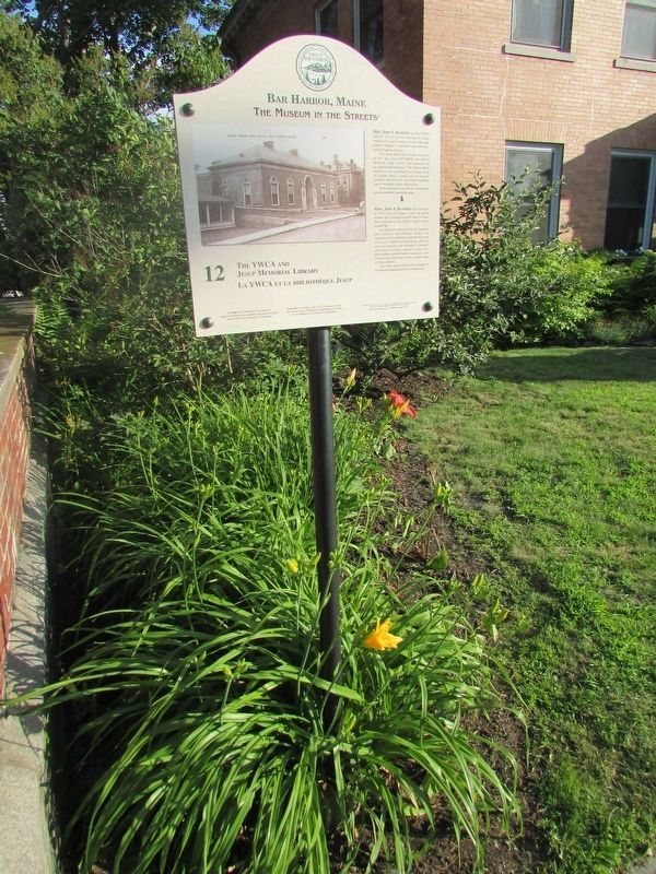
Located in the center of town, this 1.5 acre site was originally home to the Grand Central Hotel, which was torn down in 1899. That same year, the Town of Bar Harbor purchased the land, set it aside as public open space and
leased it to the . . . — — Map (db m184630) HM
You are standing on granite rock formed millions of years ago when a very hot liquid cooled deep below the Earth’s surface. Trapped in a magma chamber more than two miles deep, the 1,652°F (900° C) liquid crystallized into the mineral rich, pink . . . — — Map (db m105918) HM
Long before Europeans arrived, Wabanaki people hunted, fished, gathered berries, and harvested clams on what we now call Mount Desert Island and Acadia National Park. For generations, Wabanaki craftspeople sold handmade ash and sweet-grass baskets . . . — — Map (db m105696) HM
It is a job like no other. Most weeks, park rangers wear many hats. Some help people learn about wildlife. Others patrol trails, answer questions, and help folks stay safe. Some shine light on American history to build understanding of who we are . . . — — Map (db m106586) HM
house; dwelling; building; in Passamaquoddy and Maliseet The exhibit before you is a handmade, traditional birchbark wigwam originally built by Penobscot artist Barry Dana and his family in August 2011. Like all homes, it requires yearly . . . — — Map (db m105700) HM
Among the best known and most photographed spots in Maine, the Bass Harbor Head Light was built in 1858 to mark the bar across the eastern entrance to Blue Hill Bay. The grounds and residence of this facility now comprise the private residence of . . . — — Map (db m3813) HM
Bass Harbor Head Light stands at the southernmost tip of Mount Desert Island and marks the entrance to Blue Hill Bay and Bass Harbor. Since 1858 it has warned mariners of navigational hazards along this rocky shore.
In the nineteenth century, . . . — — Map (db m95426) HM
This property has been placed on the National Register of Historic Places by the United States Department of the Interior Bass Harbor Head Light Station 1858 — — Map (db m105405) HM
Maine boasts more than 70 lighthouses – an indication of the over 3,400 miles of shoreline that weaves in and out of craggy cliffs and cobble beaches along this rugged coast. Built on rocky promontories and offshore islands, the lighthouses . . . — — Map (db m105672) HM
Photo captions starting center left at main illustration and going clockwise:
Penobscot Expedition
On July 28, 1779, in what is known as the Penobscot Expedition, American forces led by the Marines stormed the western bluffs of the . . . — — Map (db m145059) HM
To take advantage of electricity supplied from the Wyman Dam in Bingham construction began on the Bucksport Mill in 1928 on the site of a former tannery along the banks of the Penobscot River. In its early days, the mill produced newsprint that was . . . — — Map (db m148398) HM
Welcome to Bucksport’s Museum in the Streets Historic Walking Tour
This place where the Penobscot River mets Penobscot Bay has been the homeland of the Penobscot people and their Wabanaki relations for thousands of years. Penobscot . . . — — Map (db m233968) HM
Construction of Fort Knox began in 1844 and was halted while still unfinished 25 years and $1 million later. The Fort has never seen any military action. The largest of 133 total cannons fired a 315 pound shell 4,680 yards. The granite was quarried . . . — — Map (db m55114) HM
A Good Sign
The sign post behind you symbolizes Bucksport's special place in the world, a town that many would proudly boast as unlike any other in the universe! People from all 4 corners of the
globe find their way here, some to visit, . . . — — Map (db m183890) HM
To the Top of the World
The beginnings of an historic journey to the
North Pole took place across the bay at the
McKay and Dix Shipyard on Verona Island
when the keel for a 185-foot, 650 ton wooden
sail-steamer named the . . . — — Map (db m183886) HM
The Penobscot River is a vital resource. In the 1700's it spawned numerous riverside communities, while the 1800's saw Bangor become the "lumber capital of the world", and Bucksport an international port renowned for shipbuilding. Crafted along . . . — — Map (db m55115) HM
A Past of Ports
The Penobscot River has played an important role in the history and development of the Town of Bucksport. This site where you are standing was once occupied by a commercial wharf, one of many along Bucksport's waterfront in . . . — — Map (db m183844) HM
"Panawap'skewtekw,” meaning "River of rocks spreading out” is the original, indigenous name for the Penobscot River. According to an ancient Penobscot legend, the river was created when Guards-Water, a giant frog monster . . . — — Map (db m183889) HM
At this site and adjacent to Mill Stream is the location of the first sawmill built in 1764 by Jonathan Buck. The mill provided boards, staves, shingles and clapboards needed by the settlers as well as for sale in Boston and more distant ports. The . . . — — Map (db m148399) HM
This monument was erected
in memory of Colonel Jonathan Buck,
founder of Bucksport, who died on March 13, 1798
The memorial, built of Blue Hill granite, was erected
by his descendents nearly sixty years after his death.
Sometime after its . . . — — Map (db m145041) HM
THE MILITARY HISTORY of our nation came to Bucksport quite dramatically over the centuries. The young settlement was occupied by the British during the War of 1812 and gained its most prominent view, Fort Knox, in the 1840s, built to protect . . . — — Map (db m233480) HM
In 1763 Jonathan Buck settled the area, which was subesequently burned during the Revolutionary War. First incorporated as "Buckstown", the name was changed to "Bucksport" in 1817. In the 1800's Bucksport thrived as an international port. Later . . . — — Map (db m55112) HM
Battle on the River
In 1779, the early settlers of Bucksport witnessed a devastating military defeat for the Americans during the Revolutionary War. A fleet of 44 warships and support vessels from the Continental Navy Fleet set out on a . . . — — Map (db m183880) HM
This unique suspension bridge opened in 1931. The total span 2040 feet (about 7 football fields) at a height of 135 feet. Each 206 foot tower rests on a concrete pier, that required six days of continuously pouring concrete to build. Final cost for . . . — — Map (db m148396) HM
This Fortress, originally known by its garrison as FORT PENOBSCOT and named by Admiral Sir George Collier in his reports FORT CASTINE received its present designation from its builder, British general Francis McLean upon its completion in December . . . — — Map (db m77148) HM
This fort, originally known by its garrison as “Fort Penobscot” and named by Admiral Sir George Collier in his reports “Fort Castine” received its present designation from its builder, British general Francis McLean upon its . . . — — Map (db m77147) HM
Built in 1780 by Colonel Campbell, named in honor of his regiment, H.B.M. 74th - “The Argyle Highlanders,” following a southerly direction to the shore.
Upon the explosion of the Tory refugees - September-October, 1784, a . . . — — Map (db m77152) HM
In honor of the men of Ellsworth who served, and to the memory of those who fell on land and sea in the war for the Union, their grateful townsmen have raised this memorial.
1861 - 1887 — — Map (db m54537) WM
In honor of the citizens of
the Town of Franklin
who served their country in the Civil War
[Honor Roll of Veterans]
Dedicated May 30, 1923 — — Map (db m55094) WM
In Hancock County, the granite industry was
most significant between the years 1870 to
1910. Franklin and Sullivan became the main
source of paving and curbing stones for the
major US cities: Boston Philadelphia,
Providence, Washington, DC . . . — — Map (db m233950) HM
The Granite Industry of Franklin and Sullivan
Quarrying granite in eastern Hancock County was centered in the towns of Franklin and Sullivan. The quality of granite found around Tranton and Hog Bay was high. The Bays provided an easy way to . . . — — Map (db m234536) HM
In memory of
Militiamen - Rangers of Plts. 8 8-9. Now
Franklin
who served in
1775 - Revolutionary War - 1781
Defense of Machias - Frenchman's Bay - Siege of Bacaduce
Jeremiah Bragdon ·
John Bragdon ·
Moses Butler Sr. ·
Moses . . . — — Map (db m233874) HM WM
This
historic galamander (granite lifter) was
used in the local quarries for nearly a hundred
years. As far as we know, it is the only
surviving complete machine and stands as a
memorial to the granite industry that flourished
from 1820-1940. . . . — — Map (db m234315) HM
September 25, 1918
“Dismissal of Incompetent Persons
Any incompetent person or persons who may be employed on the work shall be removed on the requisition of the owner or engineer; and no person so removed shall . . . — — Map (db m102501) HM
Honor Roll
W.W. I
Lester J. Lurvey • Ralph W. Reynolds
W.W. II
Leslie D. Wright • Julian G. Smith • Donald F. Graves
Joseph P. Chase Jr. • Francis G. Kelley
Kenneth F. Grindle • George M. Chilles
Korean War
Robert . . . — — Map (db m54456) WM
You are standing by Somes Sound, one of only a few US fjards – glacially carved valleys drowned by the sea. This five-mile-long bay has attracted people for thousands of years. English homesteaders Abraham and Hannah Somes and James and . . . — — Map (db m106549) HM
You are standing beside the only fjord on the east coast of the United States. A fjord is a long, deep, and narrow valley carved by glaciers and flooded by the sea.
At this narrow place between Acadia and Norumbega Mountains, a concentrated ice . . . — — Map (db m54484) HM
Prospect Harbor and beyond: Beacons of
safety built to endure storm, tide and wave
Lighthouses are monuments to 19th century engineering and design with their hewn rock foundations, spiral staircases, sloping conical towers, and Fresnel lens. . . . — — Map (db m184521) HM
Established in 2017 for the citizens of Gouldsboro through the generosity of one of its own.
Gouldsboro peninsula is thirty thousand acres of granite, heath and shallow soil, two mountains and two ponds. On a point in West Gouldsboro, . . . — — Map (db m184603) HM
Dorcas Library
In 1932 the Dorcas Society,
a Christian women’s group in Prospect Harbor that did good works for the community with
money raised from sewing projects, erected a small building here with two rooms. One room was for sewing and the . . . — — Map (db m183938) HM
Prospect Harbor "is the home of sea
Captains…who sail the high seas…eleven in number. Many own ships built in the area."
"Roads of that time were few and bad" In contrast, the sea offered an open road to travel and trade. Winds blowing . . . — — Map (db m184556) HM
“The construction of these two lodges marks a step well considered in the development of the (carriage road) system and… marks a step in development of the whole island and for the Park, since such beautiful structures just . . . — — Map (db m102504) HM
Ancient ice and powerful waves worked for eons to round the cobbles that grace Acadia’s beaches. Glaciers carried many of them great distances to this spot. Now the sea endlessly tumbles them with local rock creating an ever-changing mosaic of . . . — — Map (db m106551) HM
A Part of History
Both Native Americans and early settlers enjoyed abundant harvests along this coastal shore. Each spring, thousands of adult alewives made an upstream pilgrimage, moving from salt water into the Mill Pond and up Somes Brook . . . — — Map (db m54520) HM
Many of Maine’s beaches are covered with cobblestones, but here powerful ocean storms have assembled them into a massive seawall. As the waves break, they scour rocks from the base of the beach and carry them up on the shore. As the tide rises, the . . . — — Map (db m105668) HM
This stone cutter proudly stands as a tribute to the many workers whose labor and dedication have made this region known internationally as the home of Deer Isle Granite.
The sculpture by William Muir was given to the Town of Stonington by . . . — — Map (db m145043) HM
Dedicated in honor of the service men and women of Stonington who served their country in time of war and peace and in cherished memory of those who sacrificed their lives in the cause of American liberty — — Map (db m86970) WM
In the 1800s when ship building, quarrying and mining thrived, enterprising businessmen built boarding houses and hotels to house the many laborers. Blacksmith shops, livery stables, grocery and feed stores, and a meat shop flourished as well. . . . — — Map (db m54711) HM
With the help of steamship & train travel in the late 1800s, summer tourism peaked. But within a few short decades, the age of the auto and better roads to Bar Harbor - plus closing mines and quarries - led to decades of gradual economic . . . — — Map (db m54709) HM
All the mountains that you see are part of Acadia National Park
The Age of Sail lingered into the 1900s as sailing ships proved more economical than steamships for carrying heavy cargos such as granite.
Generations of watercraft ply . . . — — Map (db m54707) HM
Bass Harbor Head Light stands at the southern most tip of Mount Desert Island and marks the entrance to Blue Hill Bay and Bass Harbor. Since 1858 it has warned mariners of navigation hazards along this rocky shore.
In the nineteenth century, the . . . — — Map (db m102500) HM
With deep gratitude and
In memory of those who
Freely gave their live and
Services in the Great War
For Freedom and Democracy
This tablet is placed here.
A.D. 1919 — — Map (db m184637) WM
Directly across Frenchman Bay... the beautiful group of islands, which, like stepping stones, form a connecting line to Mount Desert... Pennsylvania Railroad Company's Summer Excursion Book, 1891 Water was the primary . . . — — Map (db m184514) HM
Wander Winter Harbor and find traces of our past. Our architecture tells a story of seafaring fishermen and traders, 19th century summer rusticators, grand public buildings, and
ongoing adaptation to new opportunities.
1.Channing Chapel . . . — — Map (db m184163) HM
Fires were all too common in the days of open flames, wood stoves, candles, and oil lamps. Bucket brigades and hand-pump fire engines were often not enough. Fires reshaped Winter Harbor in 1887, 1891, 1902, 1915, 1922, and 1931. Yet determined . . . — — Map (db m184158) HM
Schoodic Peninsula Acadia National Park
Dedicated to the memory of
John Godfrey Moore
1848 - 1899
A Maine man who loved his native state, wherein he spent with his family, some of the happiest days of his life. He owned Schoodic . . . — — Map (db m184691) HM
On November 11, 1938,
U.S. Park Ranger
Karl A. Jacobson
was fatally shot while patrolling
the Schoodic District
of Acadia National Park.
His service and sacrifice to the
National Park Service and to
the people of this country
will . . . — — Map (db m184133) HM
Winter Harbor Light (active 1856-1930)
For years the staunch little sentinel beacon on Mark Island guarded the entrance to Winter Harbor Sound, lighting the way for ships and small craft to the safety of snug Winter Harbor. The Coast Guard . . . — — Map (db m184638) HM
As part of a deal brokered by John D. Rockefeller Jr., the National Park Service built this structure in 1935 to house Navy personnel and top-secret radio operations.
In exchange, the Navy moved its base from Mount
Desert Island to make way for . . . — — Map (db m184690) HM
In July 1895, the first color issue of Comfort rolled off the presses to be sent nationwide to over a million subscribers. W. H. Gannett established his phenomenally successful magazine (1888-1942) to promote Giant Oxien, his . . . — — Map (db m111271) HM
An expedition under
Colonel Benedict Arnold
for the capture of Quebec
marched from this place
in September 1775
☆☆☆☆☆☆☆☆☆☆☆☆☆
To record . . . — — Map (db m110856) HM WM
Holiday shoppers on Water Street in 1932 had a brand new store to shop! That year, the S.S. Kresge five and dime store opened in a modern Art Deco building unique in downtown Augusta. The new building replaced an Italianate block . . . — — Map (db m111199) HM
On June 8, 1834, Judge Daniel Cony's home was consumed by fire. Judge Cony had erected the frame of that house on October 17, 1797, on the 20th anniversary of the capture of General Burgoyne's army. Cony was a Massachusetts militia . . . — — Map (db m186064) HM
Distinguished Citizen of Augusta
Revered by the people of the city
for years of service to them as
Physician, Counselor and Leader — — Map (db m110774) HM
In 1856, James North built Meonian Hall, named for Maeonia in Asia Minor. The Italianate building stood on the site of the Burton House, Augusta's first post office in 1789. During the Civil War, patriotic rallies and civic meetings . . . — — Map (db m111246) HM
Abraham Lincoln's assassination in Washington on April 14, 1865, as the Civil War was ending plunged Augusta into sorrow. Businesses closed on the 19th and soldiers, civil authorities, and societies converged at the black draped . . . — — Map (db m186073) HM
Welcome to Augusta
Indigenous people occupied the Augusta area for thousands of years before European explorers arrived. Little evidence remains of their time here, but patches of forested land along the Kennebec give us a glimpse . . . — — Map (db m186068) HM
Augusta in the Civil War
Civil War was now inaugurated: fifty years of dispute over slavery came to a contest of arms with the firing on Fort Sumter in Charleston Harbor by forces of the new Confederate States of America. News of . . . — — Map (db m186091) HM
Augusta in the Civil War
Civil War was now inaugurated: fifty years of dispute over slavery came to a contest of arms with the firing on Fort Sumter in Charleston Harbor by forces of the new Confederate States of America. News of . . . — — Map (db m186097) HM
These buildings were built to house the E. C. Allen Publishing Company. Allen has been called the forerunner of the advertising agency business, the pioneer of low-priced mail order periodicals, and the creator of the premium idea . . . — — Map (db m111073) HM
Not for fame or reward
Not for place or for rank
Not lured by ambition
or goaded by necessity
But in simple obedience to duty
as they understood it
These men suffered all
Sacrificed all
Dared all - and died
[Historical information excerpt at bottom of marker]
Old Fort Western and downtown Augusta sit on the site of ancient Cushnoc, the Abenaki word signifying the head of tide on the Kennebec River. Although according to the archaeological . . . — — Map (db m110823) HM
News of surrender at Fort Sumter and the onset of war reached Augusta on April 12, 1861. Governor Washburn quickly approved Horatio Staples' call for Augusta volunteers, who joined others at Capitol Park to form the 3rd Maine . . . — — Map (db m186099) HM
In honor of the young men of the Civilian Conservation Corps who, from 1933 to 1942, changed the face of Maine by building parks, roads, trails, forests and citizenship, leaving a lasting legacy to the conservation of natural resources for which all . . . — — Map (db m111015) HM
At the request of Maine's Governor, the Federal Government established a military hospital at Camp E.D. Keyes. In operation from June 1, 1864, to November 30, 1865, the hospital was a self-contained complex equipped with operating . . . — — Map (db m186082) HM
On June 14, 1894, the cornerstones for the Masonic Temple and Lithgow Library were laid with imposing Masonic ceremonies. Parades, speeches, and feasting marked the day, and hundreds of people from all over the state participated. . . . — — Map (db m111147) HM
In commemoration of the first trading voyage of the Pilgrims of Plymouth to the ancient Indian village at Cushnoc on the Kennebec River, 1625, and on this site the establishment of their fur trading post with the Indians, 1628, Jown Howland in . . . — — Map (db m110858) HM
An endless quest for riches brought Europeans to the Kennebec River by 1607 and to Augusta by 1625. In 1628, the Plymouth (Massachusetts) Colony constructed Cushnoc Trading Post on the Kennebec riverbank at the head of navigation, . . . — — Map (db m110861) HM
In 1910, Delbert W. Adams opened a store on Water Street offering "strictly first-class goods at a fair margin of profit." In 1920, Adams moved across the street to 190 Water Street, where the store operated until it closed in 1982. . . . — — Map (db m111248) HM
This reproduction of the Liberty Bell was presented to the people of Maine by direction of The Honorable John W. Snyder Secretary of the Treasury
As the inspirational symbol of the United States Savings Bonds Independence . . . — — Map (db m128550) WM
For over 200 years, this site has anchored a span over the Kennebec River. Construction of the first bridge began in May 1797 by the Proprietors of the Kennebec Bridge, which owned and subsequently operated the bridge. Completed on . . . — — Map (db m110811) HM
The embargoes leading to war caused economic hardship in Augusta, and news of war generated disdain in this Federalist Town. Citizens mounted a protest by hanging an effigy of President Madison from the public wharf and flying an . . . — — Map (db m153146) HM
They deserve our everlasting gratitude.
This garden of remembrance is to honor our fallen heroes whose bodies were never found.
Stones have been placed to keep memories of their heroism alive.
Memorials here are for those who . . . — — Map (db m127032) WM
859 entries matched your criteria. Entries 301 through 400 are listed above. ⊲ Previous 100 — Next 100 ⊳