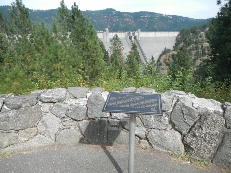
This 717 foot high concrete structure is the highest straight axis gravity dam in North America. The dam backs up water from the North Fork of the Clearwater River forming a 54-mile lake at full pool. Flood control, power production, and recreation . . . — — Map (db m159495) HM
This rock, moved here from the river's edge, was used long ago by Indian fishermen as a water flow gauge. When the water level reached the upper mark carved on the side of the rock, they began building small dams of sticks and stones, called "fish . . . — — Map (db m159496) HM
You are nearing the junction of historic Highway 11, now designated as Gold Rush Historic Byway.
Winding its way through spectacular scenery, it passes through the traditional homeland of the Nez Perce Indians on the Weippe Prairie and the National . . . — — Map (db m109758) HM
Indians have lived here next to this good fishing hold for 10,000 years.
As long as 3,000 years ago, they had large oval houses, 28 feet long by 24 feet wide. To build these houses, they put a bark and mat covering over a frame of 50 or so . . . — — Map (db m121416) HM
David Fraser, a young merchant, came to the area with a pack string headed for Pierce City, the gold rush area, to open a store in the Spring of 1863. Some people of the area encouraged Fraser to open the store here as a lot of the miners had moved . . . — — Map (db m121417) HM
This 10 acre park was a part of the original homestead of John Cattron, who homesteaded the 160 acres in 1890.
Lewis and Clark passed through the park on the old Nez Perce Indian trail that went through the park in 1805. Clark returned to the . . . — — Map (db m121437) HM
The brass monument nearby is provided by the Idaho Society of Professional Land Surveyors in cooperation with the National Geodetic Survey to commemorate the “Lewis and Clark” Corps of Discovery campsite at Canoe Camp, Idaho.
. . . — — Map (db m110468) HM
Lewis and Clark called this place Canoe Camp.
For 11 days in 1805 the Corps of Discovery camped here in the company of Nez Perce while building five canoes for the journey to the Pacific.
For thousands of years before that, this riverbank was . . . — — Map (db m110465) HM
Guided by Twisted Hair and several other Nez Perce, Capt. William Clark selected this as a camp site because of the many large ponderosa pines that grew here then. The canoe makers chopped out small portions of the pine logs, then used fire or . . . — — Map (db m109875) HM
Welcome to
Canoe Camp
One of 38 sites of Nez Perce National Historical Park
These grounds have been inhabited for thousands of years by the Nez Perce people, but are best known as the place where the Lewis and Clark . . . — — Map (db m109872) HM
Ever since the first cross-cut saws were heard in the remote forests of Clearwater County in the late 1800s, the Clearwater River played a major role in the timber industry of this area. The river served as a means of transportation and by the early . . . — — Map (db m159486) HM
After more than a month’s search, they finally had reached a westward river where they could use canoes.
From here they continued another 16 miles with their pack horses before they found a campsite with trees suitable for making canoes.
But at . . . — — Map (db m109757) HM
When the Lewis and Clark Corps of Discovery entered this area in September 1805, they were not only hungry, but still anxious to locate a water route to the Pacific Ocean.
Under the direction of a Nez Perce headman, Twisted Hair, the explorers . . . — — Map (db m159484) HM
Orofino is situated on the north and south banks of the Clearwater River.
The area’s mild climate and convenient location made it a thriving Nez Perce village site long before Lewis and Clark stopped here in 1805.
Lumberjack Days
. . . — — Map (db m109888) HM
Low mounds and depression in the ground here give only the faintest impression of villages that stood on both banks of the river. These are the remains of pit houses, built 1,500 to 2,000 years ago. Imagine the scene then: people spearing fish, . . . — — Map (db m109876) HM
...then crossed the River at a shole place the water to the horses bellies." - Sgt. John Ordway, Sept. 26, 1805
Clearwater Crossings
Long before we had highways and bridges, people crossed the river at this location. What . . . — — Map (db m159488) HM
Routes Through History
Travel through the rugged Clearwater River region has not always been on smooth, paved highways. Routes on land began as game trails, then foot paths which grew into horse paths. Many of these historic routes paid . . . — — Map (db m159490) HM
Canoe Camp is part of the Nez Perce National Historical Park and a key site along the Northwest Passage Scenic Byway
An Interesting Drive
The 202-mile Northwest Passage Scenic Byway stretches from Lewiston to Lolo Pass on US Highway . . . — — Map (db m109886) HM
During the gold rush boom, the population exceeded 6,000. At that time Pierce was actually located in Washington Territory. In 1861, Pierce became the first established gold rush town in Idaho, and the county seat of Shoshone County. In 1862, the . . . — — Map (db m121513) HM
The fabulous Gold Rush days of Idaho began on September 30, 1860, when W.F. Bassett struck gold just about here.
E.D. Pierce, who knew the country, had led twelve prospectors, including Bassett, out from Walla Walla in August. After news . . . — — Map (db m121518) HM
This is the site of the graves of the Chinese who died in Pierce. All bodies have been returned to their homeland. Chinese artifcts (sic) broken tools and rotting cabins are still found in the nearby hills. — — Map (db m141099) HM
Charged with hacking a prominent local merchant to pieces, five Chinese were hanged here by vigilantes Sept. 18, 1885.
They were just setting out on a long, hard 240 mile trip from Pierce to face trial at the county seat in Murray when . . . — — Map (db m121442) HM
Hearing rumors of gold in the hills, Captain Elias Davidson Pierce started his first journey from Walla Walla to this area on August 12, 1860, with a crew of ten. The crew included: Benthnel Farrell (18), Horace Dodge (22), Joseph L. Davis (37), . . . — — Map (db m121490) HM
One summer's night in 1885, it is alleged that five Chinese men gained entrance to the Fraser General Store, while their fellow countrymen set-off fireworks up and down Main Street. It was a stormy night and the fireworks supposedly helped drive-off . . . — — Map (db m121515) HM
Commercial center of Idaho's earliest mining district in the great days of 1861. It flourished here for more than a year.
Pierce City was only 2 miles away but another town sprang up near some rich gold strikes. In its first few weeks, Oro . . . — — Map (db m121517) HM
When the courthouse was built in 1862, Pierce was a boomtown. Gold discovered in the nearby hills was attracting thousands of miners. There was one catch: they were all trespassing on Nez Perce land.
The government solution was to draw up a new . . . — — Map (db m121579) HM
Shoshone County's original courthouse -- and Idaho's earliest public building -- still stands in Pierce., where it was built in 1862.
Although Pierce gained a large population for a year after gold was discovered here in 1860, most of the . . . — — Map (db m121520) HM
A few weeks later, a larger group of men and horses made a second journey to Pierce. The group passed near several Nez Perce Indian encampments, which had not seen many white men since Lewis and Clark passed through almost fifty years prior. The . . . — — Map (db m121512) HM
After the hardships of the mountain passage, the Weippe Prairie was a place of relief for the Corps of Discovery. The Nez Perce befriended them and renewed their hope of reaching the Pacific Ocean.
"the pleasure I now felt in having tryumphed . . . — — Map (db m121438) HM
To the East, one can see the often snow capped Bitterroot Mountains. These mountains proved to be one of the most difficult barriers for the Corps of Discovery. Twice they needed to cross the mountains and twice they faced them with trepidation. . . . — — Map (db m315091) HM
The brass monument nearby is provided by the Idaho Society of Professional Land Surveyors to commemorated the "Lewis and Clark" Corps of Discovery campsite near Weippe Prairie, Idaho.
Datum NAD 83 and NAVD88
Latitude N 46º21' 00" Latitude . . . — — Map (db m121581) HM
I Set out early and proceeded ... to a Small Plain in which I found maney Indian lodges ... I met 3 Indian boys, when they saw me they ran and hid themselves. -- Capt. William Clark, September 20, 1805
After Lewis and Clark's Corps of . . . — — Map (db m121582) HM
In late September of 1805, three young Nez Perce spied several men dressed in strange clothes and hats coming from the ridge to the southeast. The boys hid, but the men discovered two of them in the area behind this sign. The boys led these men to . . . — — Map (db m232854) HM
Journeying toward the Clearwater, 6 men under Clark met the Nez Perce Indians not far from here, September 20, 1805.
Clark first saw 3 frightened Indian boys who hid in the grass. Finding two, he reassured them with small presents and "Sent . . . — — Map (db m121439) HM
This marker was dedicated
1957
to commemorate the arrival of the Lewis and Clark Expedition at Weippe Prairie, Idaho, Sept. 23, 1805. Also to honor the memory of Dr. J.T. Moser who pioneered here in the 1890's and to honor the memory of his . . . — — Map (db m121440) HM
Welcome to Weippe Prairie
This has always been a traditional gathering place for the Nez Perce people where camas bulbs are harvested and baked each year. The blue flower of the camas lily grow so thick here in the spring time that from . . . — — Map (db m121610) HM
On May 31, 1806, Sgt. John Ordway and Pvts. Frazer and Weiser began the return trip from Lewis’s (sic) River (Snake River) with salmon for Camp Chopunnish (Kamiah). The men crossed the Camas Prairie near here on their way to rejoin the Corps . . . — — Map (db m121141) HM
Following the Battle at White Bird Canyon on July 4, 1877, U.S. cavalrymen, entrenched nearby at Cottonwood, resisted attacks by Nez Perce warriors.
East of here on July 5, 1877, Nez Perce warriors created a strategic diversion by surrounding . . . — — Map (db m121140) HM
“I will not hide anything. That part of the fight was not long.” Yellow Wolf, Nez Perce warrior.
On July 3, 1877, 2nd Lt. Sevier M. Rains, civilian scout William Foster, and ten 1st cavalrymen rode from Norton’s ranch . . . — — Map (db m121142) HM
Erected in memory of the seventeen volunteers who engaged in battle with the Indians 2000 feet East from this point with two killed and three wounded the 5th day of July 1877 during the Nez Perce Indian War. Captain D.B. Randall, C.M. Day, James . . . — — Map (db m121144) HM
An exceptionally large hydraulic pit, left by massive placer mining in this area, still can be seen 1 mile from here.
Buffalo company miners using hydraulic giants -- large metal hoses with nozzles that could direct a stream of water under . . . — — Map (db m121285) HM
Twenty-two prospectors from Pierce discovered the Elk City mines in May, 1861 and a gold rush followed that Summer.
Through July the houses were "nice and airy, being constructed of brush." with bars for doors "to keep out the cayuse horses." . . . — — Map (db m121287) HM
Elk City was the first mining town in Idaho County. The first miners saw a herd of at least 700 elk while camping on the hill east of the present townsite, hence the name Elk City. In September 1861, Elk City was established between Elk City and . . . — — Map (db m121316) HM
An old Indian trail connected Elk City with mines in Montana when Idaho's gold rush spread in 1862. Following a route developed by Nez Perce buffalo hunters, a host of miners and packers ascended a series of ridges overlooking deep Salmon and . . . — — Map (db m121289) HM
The Lewis and Clark Expedition passed through the valley of Hungery Creek in late September 1805, and on their return journey in late June, 1806. Five of the party's campsites are located in this valley to the south. Here you can see the extent of . . . — — Map (db m140826) HM
Arriving here in late September 1805, Captain Lewis and a contingent of the Corps of Discovery were cold and hungry. Wearing only worn moccasins, they had struggled over rough, hilly terrain. Climbing over fallen trees and through log strewn creek . . . — — Map (db m140834) HM
On June 17, 1806, the Lewis and Clark Expedition left their camp in Hungery Creek to ascend into the mountains. The party encountered deep snow at the top of the ridge and was forced to turn back. Captain Lewis wrote, "...this is the first time . . . — — Map (db m140829) HM
In June 1806, the Lewis and Clark Expedition members were in good spirits as they began their journey home over the Lolo Trail. Although the men were well fed, rested an had 66 horses to ride and carry their gear, the trails were still very slippery . . . — — Map (db m140832) HM
"The country is thickly covered with a very heavy growth of pine of which I have ennumerated 8 distinct species." Capt. Meriwether Lewis, September 19, 1805
The landscape today may look very similar to the one Lewis and Clark described, . . . — — Map (db m140828) HM
Can you imagine mammoths walking the streets of Grangeville? Before Sept. 2, 1994, no one else could either. But on that date, a heavy equipment operator for Prairie Land and Timber, found a "big bone" when he was digging in Tolo Lake. That . . . — — Map (db m141309) HM
Named for the blue flowering camas -- an important root food for all interior Northwestern Indians -- Camas Prairie is a traditional Nez Perce cultural center. Tolo Lake -- visible below -- provided a campground for Joseph’s Wallowa band and . . . — — Map (db m121138) HM
(Three panels outline the history of Tolo Lake)
The Nez Perce name for this lake is Tipahxlee’whum (Tepahlewam or Split Rocks). In early June 1877, five bands of Nimiipuu gathered here for their last taste of freedom before . . . — — Map (db m121267) HM
During the decade following the discovery of gold in the California mill race in 1848, restless bands of prospectors, lured by the hope of sudden wealth, arrived in what is now north-central Idaho. In 1860, gold was discovered on Canal Gulch of . . . — — Map (db m141251) HM
Grangeville owes its origin to members of the Charity Grange #15, Patrons of Husbandry, organized in Mount Idaho in 1874. John M. Crooks, owner of a 600-acre ranch on Three Mile Creek, gave the Grangers land for a hall, an additional five acres, and . . . — — Map (db m141247) HM
Near the base of this hill, over 100 cavalrymen and volunteers met disaster in the opening battle of The Nez Perce War.
Rushing from Grangeville on the evening of June 16, 1877, Captain David Perry planned to stop the Indians from . . . — — Map (db m4643) HM
For thousands of years, Nimiipuu, or Nez Perce ancestors migrated between forest, river, and prairie environments, harvesting the resources as they came available with the passing seasons.
Seasonal Round
The Nimiipuu daily rhythms and . . . — — Map (db m121270) HM
The steam engine before you saw many years of service to agriculture and lumbering here on the Camas Prairie at the turn of the 20th century.
In the 1920s the City of Grangeville used a steam engine like this with a roller in front instead of . . . — — Map (db m121269) HM
Before the continent was called America, before settlers came looking for land, the Nez Perce people lived and traveled throughout a vast area we now know as Idaho, Oregon, and Washington. They lived a semi-nomadic lifestyle, following the growing . . . — — Map (db m141249) HM
Look Up!
You're looking up at a full-size replica of the skeleton of a male Columbian mammoth. Mammoths are related to modern Asian elephants. Males stood up to 14 feet tall at the shoulders and may have weighed 10 tons. Females were . . . — — Map (db m141310) HM
Homesteaders flocked to the Camas Prairie in the early 1900s. Lured by the rolling, fertile land, John, Jake, and Gib Eimers, brought their hopes and dreams to Grangeville from Albion, Illinois. Soon after, sisters Elsie Eimers Bunting, Helen . . . — — Map (db m141254) HM
War has a way of making heroes and heroines of ordinary mortals. To some, Tolo, a Nez Perce Indian woman, was never ordinary. Her given name was Alab-lemot but because she loved to gamble, she was called Tolo which means "win" in the Chinook tongue. . . . — — Map (db m141246) HM
A scenic 1895 wagon road from Harpster to Elk City gave freighters and travelers better access across high ridges and rugged terrain to isolated mining camps
Sections of the steep, narrow road run close to a much older Nez Perce trail that . . . — — Map (db m123511) HM
During the mining boom Harpster boasted a hotel, a livery barn, a harness shop, four saloons, two general stores, a a drug store, and a blacksmith shop.
William Jackson built a toll bridge here across the South Fork of the Clearwater to meet . . . — — Map (db m121318) HM
Coming here May 10, 1839 to study with Lawyer, an important Nez Perce leader, he stayed to work on an Indian dictionary and to hold daily religious classes each spring and winter.
After spending six months in a “mere hovel,” he finished . . . — — Map (db m109774) HM
In May and June, they camped across the river from present-day Kamiah near the railroad bridge.
With their Nez Perce friends, they hunted, traded and played games.
They showed the Nez Perce “the power of magnetism, the spye glass, compass, . . . — — Map (db m109771) HM
Look north to the ridgeline behind you and see what Lewis and Clark and the Corps of Discovery faced on the morning of September 15, 1805. At 7 a.m. the Corps left their Colt Killed Camp near what is now the Powell Ranger Station.
Hoping for a . . . — — Map (db m123161) HM
President Thomas Jefferson, driven by a life-long passion for scientific exploration and study, instructed Meriwether Lewis to record details about the flora, fauna, geology and people of the land between the Missouri River and the Pacific Ocean. As . . . — — Map (db m123162) HM
Have you seen a duck with a clown's face?
Harlequin duck pairs live on the exposed rocky Pacific Northwest seacoast for most of the year. In the spring you may see the colorful male duck here along the Lochsa River.
Like the salmon, . . . — — Map (db m315123)
In September of 1805 and again in June of 1806, Lewis and Clark traveled and mapped this area.
Their purpose was to explore the land, communicate with the Indians and establish the claim of the United States to the vast Pacific Northwest.
. . . — — Map (db m110304) HM
Westward 1805 - Look up Fish Creek to your right and you will see into the rugged backcountry traveled by the Corps of Discovery. The expedition journeyed through the up portions of this drainage, which Clark called "Hungery Creek."
Hungry, . . . — — Map (db m315105) HM
The townsite of Kooskia is situated within the Nez Perce Indian Reservation. Between 1889-1893, the Federal Government divided the 756,960-acre reservation into family-sized acreages called allotments. Although each Nez Perce adult and child . . . — — Map (db m121323) HM
(Four historical panels are located at the kiosk:)
The Lewis and Clark Expedition
The Lewis and Clark expedition known as the Corps of Discovery, passed through this area in September and October of 1805, on its way to find . . . — — Map (db m121344) HM
Route of September 15, 1805.
The Lewis and Clark Expedition passed through this area on their westward journey following a route used by the Indians to reach Salmon fishing grounds in the Lochsa River. The Indian trail they were following left . . . — — Map (db m123215) HM
Captain Lewis recorded on June 29, 1806: "...at noon we arrived at the quamas flatts (sic) on the Creek of the same name and halted to graize (sic) our horses and dine having traveled 12 miles. We passed our encampment of the (13th) September at 10 . . . — — Map (db m123219) HM
Looking Glass told army authorities: “Leave us alone. We are living here peacefully and want no trouble.”
But after a military attack, July 1, that destroyed his village, ruined his gardens and captured 750 Nez Perce horses, Looking . . . — — Map (db m109790) HM
You can find me on the ridgeline above you. I’ve seen many pass this way, some in joy and some in sadness, some in peace and some in war. For the Nimiipuu (Nez Perce) I was K’useyneisskit or ‘road to the buffalo.’ For the Selish (Salish) I was . . . — — Map (db m123165) HM
On July 23, 1877, approximately 750 members of the Nez Perce Nation, with over 2,000 horses, crossed Lolo Pass to escape the pursuing U.S. Army. Leaving their homeland behind, they followed this trail across the Bitterroot Mountains in an attempt to . . . — — Map (db m123218) HM
Living in Harmony with the Land You are standing near one of the well-worn trails and a crossroads of the Nimiipuu (Nez Perce) and Selish (Salish) peoples. Year round, the Mat’alaayma Bands of the Nimiipuu lived here, wintering along the . . . — — Map (db m123172) HM
Over one and one-half centuries have passed since Lewis and Clark crossed the Bitterroot Mountains.
This country was then a vast, challenging wilderness.
Immediately across the river from you, at this point, is the Selway – Bitterroot . . . — — Map (db m110320) HM
In July of 1877, nearly 800 Nimiipuu (Nez Perce) people traveled with heavy hearts across the Lolo Trail above you. They did not know if they would ever return to their homes. The women sang songs of sorrow and longing.
The journey began in the . . . — — Map (db m123163) HM
(This marker is composed of two panels and is presented here as if the panels were joined.)
The land today looks much the same as it did to Lewis and Clark. Today, as stewards of this beautiful land, we have an opportunity to leave a . . . — — Map (db m123213) HM
Above the parking lot is an open glade where natural mineral licks attract a variety of wildlife. These licks were named after George Colgate who was the cook for a hunting party in the early 1890s. Heavy snow trapped the group and prevented them . . . — — Map (db m123164) HM
The Lochsa River is one of the few remaining river systems where Chinook salmon and steelhead trout still spawn. These anadromous (ocean going) fish fight long and hard to return to this very place from the Pacific Ocean. During the . . . — — Map (db m315125)
85 ► Idaho, Idaho County, Lolo — 334 — Lolo Trail Crossing — When Lewis and Clark came up this ridge June 29, 1806 — they ran into "a shower of rain, with hail, thunder and lightning, that lasted about an hour" —
But they got out of deep Lolo Trail snow after they reached Rocky Point (directly across from here) and descended to Crooked Fork, below this turnout.
They reported that then they “ascended a very steep acclivity of a mountain about 2 . . . — — Map (db m109787) HM
On their westbound journey, Lewis and Clark crossed here, September 15, 1805 after camping 4 miles upstream at Powell.
Their Shoshoni guide had brought them down an old trail from Lolo Pass to a Lochsa fishery he knew about. To continue west, . . . — — Map (db m109782) HM
Many changes have occurred since the time Lewis and Clark used this route in the early 1800’s.
The mountains you see around you are now shared by the U.S. Forest Service and the Plum Creek Timber Company.
Each owns alternate sections of land . . . — — Map (db m109789) HM
The Lewis and Clark party crossed this pass Sept. 13, 1805, westbound for the Pacific after a long detour to the south.
From the headwaters of the Missouri they had crossed the mountains to the Salmon. Finding that river impassable, they traded . . . — — Map (db m27120) HM
Millions in gold – mined mostly in one big year came from the high mountain basin around Florence 14 airline miles east from here.
Early prospectors, fanning south from Pierce – Idaho’s first gold camp – came unexpectedly upon rich . . . — — Map (db m109650) HM
Visible directly across the river is a pit left by large scale hydraulic mining for gold deposited in ancient gravel beds.
Big nozzles, called “hydraulic giants,” shot powerful streams of water against a pre-historic river . . . — — Map (db m109642) HM
In 1862, a noted Western scout, Mose Milner, started Mount Idaho on his gold rush trail.
But when civic leaders resisted farm efforts to organize a grange there in 1874, Grangeville grew up as a better located town. Although Mount Idaho . . . — — Map (db m121317) HM
Over eleven thousand years ago, groups of Native Americans started the long history of land use in this area. The Nez Perce Tribe carried on the rich tradition of hunting, fishing, and gathering food, herbs and wood. Mountain men and early . . . — — Map (db m119353) HM
Pulled by two horses, one on either side of the rake, this device was used to gather hay for stacking. The buck rake would pick up the windrows of hay made by the dump, or side delivery rake. When loaded, the hay would be taken to the stack yard . . . — — Map (db m246283) HM
Early settler Charlie Clay, who operated a sheep ranch at Berg Creek, needed a better way to get his sheep across the river to the shearing plant located at the confluence of the Little Salmon and Salmon rivers. If the weather was bad or he felt . . . — — Map (db m119360) HM
Riggins’ first store was opened in 1897 by George Curtis, a storekeeper from nearby Lucile. Curtis converted Riggins’ first saloon into a much needed general store.
In 1903, Maggie Clay Rhoades and her sister, Carrie Belle Clay, hired carpenter . . . — — Map (db m119447) HM
First School (photo upper left)
The area’s first school opened its door in 1894 on a flat near the river in north Riggins. The small log cabin, with few windows and a fireplace, served as the classroom for fourteen students in grades . . . — — Map (db m119448) HM
Before the wagon road from White Bird to Meadows was completed in 1903, travelers endured a trecherous (sic) and roundabout overland journey. Seeing the need for a faster and more direct route, the enterprising J.J. Goff offered ferry service across . . . — — Map (db m119414) HM
Before recorded history, the area we know as Riggins was on the west coast of the North American Continent. Thousands of miles to the west was the Pacific Plate, covered by ocean with only a few high points rising above the water. This plate was . . . — — Map (db m119411) HM
If trees could talk, the big locust standing guard near the corner of Salmon Street might tell us all the details of the famous Gouge-Eye fight. It seems that Homer Levander and Big Markham got into a fight over comely Daisy Trumbull. According . . . — — Map (db m119358) HM
After a field has been plowed, it would then be necessary to break up the clods or cumps of sod and prepare the field for planting. Pastures also had to be maintained. The harrow devices which you see on display were used to accomplish these . . . — — Map (db m246295) HM
15277 entries matched your criteria. The first 100 are listed above. Next 100 ⊳