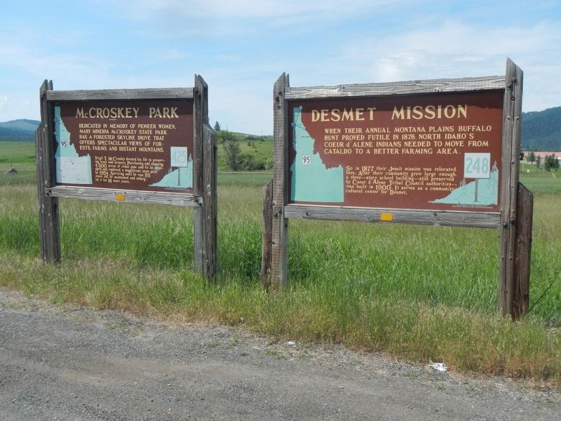
When their annual Montana plains buffalo hunt proved futile in 1876, North Idaho's Coeur d' Alene Indians needed to move from Cataldo to a better farming area.
So in 1877 their Jesuit mission was relocated here. After their community grew . . . — — Map (db m122035) HM
... was a man who had many gifts to share. Perhaps the largest gift he ever bestowed was this state park; 4,400 acres of which he donated in 1955, in memory of his mother Mary Minerva McCroskey. Virgil was anything but a selfish man. He received . . . — — Map (db m122032) HM
If these walls could talk, many interesting stories would be told. Using materials from the surrounding area, James (Jerry) G. Marsh constructed this log building in 1933 & 1934, and it was the first tavern in Benewah County to have a beer license. . . . — — Map (db m122022) HM
Dedicated in memory of pioneer women, Mary Minerva McCroskey State Park has a forested skyline drive that offers spectacular views of forest, farms, and distant mountains.
Virgil T. McCroskey devoted his life to preserving trees and . . . — — Map (db m122036) HM
The Coeur d’Alene people are the earliest inhabitants of this area.
The natural wealth of the forests, rivers, and lakes sustained their existence for countless generations on five million acres of ancestral land.
Their lifestyle was . . . — — Map (db m110383) HM
T"nt"nmi, was one of the last Coeur d'Alenes to leave permanent residence along the lake, after tribal members were assigned farm homes under the Allotment Act.
At Hnpetptqwe’n, he hosted regular gatherings and celebrations, where guests . . . — — Map (db m110411) HM
John Mullan was the Army officer who in 1859-1862 surveyed and built the Mullan Road
from Walla Walla, Washington to Fort Benton, Montana.
The road was to connect the Missouri and the Columbia, and Congress approved in 1855.
Indian . . . — — Map (db m110031) HM
Capt. John Mullan U.S. Army
Capt. John Mullan, US Army, Constructor and surveyor.
He was directed to mark a wagon and railroad route from Fort Benton, Montana to Walla Walla, Washington from 1853-1855.
He built the actual road . . . — — Map (db m110000) HM
Loggers used the splash dam system in the Marble Creek basin between 1915 and 1931.
In 1923, Rutledge Lumber Company spent $16,352.25 building the dam depicted in this mural.
Splash dams stored enough water to “flush” logs down . . . — — Map (db m109997) HM
The Saint Maries River Valley was said to have the largest single stand of white pine in the world. Homesteaders and lumberjacks flocked here by wagon road and boats to take advantage of vast stands of western white pine, fir, tamarack and cedar. . . . — — Map (db m122621) HM
“A locomotive without wheels…”
The Willamette donkeys were fueled by wood or oil, which generated steam to turn drums that were spooled with cable.
Cables of 8,000 to 12,000 feet length were common.
Because of the long lengths of cable . . . — — Map (db m109998) HM
It served as a Men's Club until 1906 then as a home and treatment center for "Doc" Thompson into the 1920's. Purchased & restored by Raleigh Hughes after 1926. Purchased by the Centennial Committee in 1989.
— — Map (db m122625) HM
Before the construction of the Post Falls Dam in 1906 the water level of the lake was lower from what you see now. In those days there were Coeur d'Alene camps near here at Ch'mi'wes, the land between Round and Benewah or Chatcolet Lakes. Plentiful . . . — — Map (db m122619) HM
Established November 4, 1842, by Father Nicolas Point, S.J.
Eagerly sought by the Coeur d'Alene Indians, the Black Robed missionaries supervised the building of a log cabin, and in the spring, began to teach "the mysteries of plowing and . . . — — Map (db m122109) HM
St. Maries, named by Jesuit Father Pierre DeSmet during the 1840s, sits at the confluence of the "Shadowy" St. Joe and St. Maries rivers. It was recognized as a settlement in the 1880s. Incorporated as a village in 1902, and as a city in 1913, it . . . — — Map (db m122624) HM
Ranger Edward Pulaski and his crew of over 40 men took refuge from the fire on August 30 in the War Eagle mine tunnel on Placer Creek.
All survived except for five men and two horses. — — Map (db m122620) HM
Designed to connect the Missouri and the Columbia, this military wagon road was constructed past here in 1859.
Swamps in the St. Joe valley has to be corduroyed with logs, and 70 men spent a week digging out sidehills south of here and . . . — — Map (db m122114) HM
During W.W. I, St. Maries was a hotbed of International Workers of America (I.W.W.) unionizing activities. In December 1917, Sheriff E. Noland raided their headquarters near here and arrested secretary William Nelson for advocating sabotage. . . . — — Map (db m122104) HM
At Mamaloose Point, two miles
South, Kullyspell house,
first trading post in Idaho,
was built September, 1809 by
David Thompson
and
Finnan Macdonald — — Map (db m112928) HM
Glaciers advanced and retreated a dozen times or more
Damming Glacial Lake Missoula
Bursting with gargantuan force
Flooding areas 400 miles away
Shaping today's landscape in Idaho, Washington and Oregon
Glacial ice above . . . — — Map (db m73493) HM
Force of energy unleashed was hundreds of times the explosive energy of Mt. Saint Helens
Flood events occurred more than a dozen times before the last torrential cataclysm of 12-15,000 years ago
Glacial Lake Missoula and the Channeled . . . — — Map (db m73495) HM
Henrietta
Tugboat for Hope Lumber
Original Thornton School
Spring Creek ca 1909
1894 Flood Changed Landscape
Destroyed buildings along the tracks
Floodwaters at level of present highway
. . . — — Map (db m73480) HM
Idaho’s fur trade began in the fall of 1809 when David Thompson built a trading post 2½ miles southwest of here. Kullyspell House (Thompson spelled “Kalispell” that way) was the earliest fur trade post in the American Pacific . . . — — Map (db m112927) HM
When the last of the continental ice sheets blocked this valley, a great lake extended over 200 miles into Montana. Ice about as high as the mountain ridges held back water as deep as 800 to 1000 feet at Missoula, ten to twenty thousand years . . . — — Map (db m73490) HM
...the falls
As you look down at the Pend Oreille (Pond O'Ray) River and Albeni Falls Dam (Albany) you may be looking for the falls. In 1887 a 26 year-old French Canadian farmer living in Blanchard, Idaho, also wondered where the falls . . . — — Map (db m109902) HM
Harnessing the Flow
During the year, the Corps of Engineers regulates the flow of water through the dam.
Water is released from Lake Pend Oreille to maintain seasonal lake elevations and to adjust for rain and snowmelt.
Water at . . . — — Map (db m109906) HM
Canadian explorer David Thompson noted a point of sand in his diary in 1809 which he believed to be near where the city of Sandpoint is today.
Settlement began in Sandpoint in the 1880s, but it was the panhandle's timber wealth that brought . . . — — Map (db m122665) HM
The Lower Kootenai people, on their seasonal migrations, were the first to travel through this area. They walked time-worn forest trails and paddled their sturgeon-nosed canoes on the Kootenai River and through the valley marshlands.
In 1808 . . . — — Map (db m122713) HM
Gold miners rushing to Wild Horse in British Columbia in 1863 were paddled across this river by Indians; in 1864 E.L. Bonner established a proper ferry here.
This ferry and its trading store served the Wild Horse packtrains for many years. . . . — — Map (db m122203) HM
Bonners Ferry riverfront today is quiet compared to the bustling center of activity it was during the 1860s gold rush. Picture prospectors and pack trains, traders and supples, all gathered here waiting to be ferried across the river to continue . . . — — Map (db m122656) HM
Coming from Canada, the famous map maker and trader for the North West Company explored this area and river in 1808.
On May 8 somewhere near here, Thompson's famished party, all sick from eating a "much tainted" antelope, met ten lodges of . . . — — Map (db m122201) HM
Harnessing water for power
Electricity and fast-flowing rivers are inseparable in the Pacific Northwest. In the early 1900s, harnessing the power of water to supply Bonners Ferry's ever-increasing demand for electricity was challenging. . . . — — Map (db m122658) HM
Moving from the north down this valley, the edge of the continental ice sheet blocked rivers and formed glacial lakes.
Then as the ice gradually melted, a lake rose here behind the receding ice dam, and extended up Kootenai valley into . . . — — Map (db m122174) HM
James J. Hill realized his vision of a northernmost transcontinental railroad in 1892, after the 1889 discovery of the Marias pass in Montana. The gentle grade and wide valley of the 5,213 ft. pass through the Rocky Mountains contrasted with the . . . — — Map (db m122715) HM
The Kootenai Tribe of Idaho has lived in their aboriginal homeland of Idaho, Montana and British Columbia for thousands of years.
A unique culture, the Kootenais are known for their distinctive sturgeon-nose canoe and their linguistically . . . — — Map (db m122202) HM
The Kootenai Valley Railroad, a subsidiary of the Great Northern, connected the main line from a spur near Bonners Ferry to the southern end of Kootenay Lake in British Columbia. Completed in 1899, its purpose was to connect with the Canadian Kaslo . . . — — Map (db m122716) HM
In the early days, this area was forested with vast swaths of huge virgin timber. As timber became less available along waterways, logging spur lines and railroad sidings were constructed to access more distant timber. Many logging camps sprang up . . . — — Map (db m122720) HM
[front side] Constructed in 1964, the 1223 ft. long steel truss bridge spans the Moyie River Canyon at a height of 464 ft. It replaces the old bridge built in 1923 and 1¼ miles of narrow, winding highway. It is the second highest bridge in . . . — — Map (db m73505) HM
This Pelton Wheel provided the power to generate the first electricity from the foot of Myrtle Creek 6 miles west of town, for the Village of Bonners Ferry from 1906 – 1921. — — Map (db m109851) HM
A vast labor force was needed during construction of the railroads. Workers came from many ethnic groups, bringing a piece of "home" with them as they contributed to the growing culture of Boundary County.
Laborers hired for low wages, . . . — — Map (db m122718) HM
Railroads brought many changes to rural life, providing access to roadless areas. Depots were built in towns like Leonia, Meadow Creek, and Addie. Passenger cars carried people comfortably on business and pleasure trips, dramatically reducing travel . . . — — Map (db m122719) HM
Semaphores were signaling devices used along railroads to control the movement of trains. The position of the blades and colored lenses told the engineer whether he should continue at the present speed, slow down and proceed with caution or move to . . . — — Map (db m122721) HM
During the 1920s, the Bonners Ferry Water and Light Department made multiple improvements to the Moyie River and Myrtle Creek power plants, but relying on hydroelectric power alone has its drawbacks. Generating electricity depended on river . . . — — Map (db m122661) HM
In 1905 Inland Empire construction magnate, D.C. Corbin, set out to build a railway line from Spokane to the international border. His plan was import coal from British Columbia to markets in eastern Washington.
The Spokane International Railroad . . . — — Map (db m122717) HM
Thousands of eager miners came by here in an 1864-65 gold rush to Wild Horse, BC. Parts of their pack trail still can be seen.
An extension of North Idaho's earlier gold excitements, Wild Horse was served by a pack trains that hauled . . . — — Map (db m122176) HM
This 717 foot high concrete structure is the highest straight axis gravity dam in North America. The dam backs up water from the North Fork of the Clearwater River forming a 54-mile lake at full pool. Flood control, power production, and recreation . . . — — Map (db m159495) HM
This rock, moved here from the river's edge, was used long ago by Indian fishermen as a water flow gauge. When the water level reached the upper mark carved on the side of the rock, they began building small dams of sticks and stones, called "fish . . . — — Map (db m159496) HM
You are nearing the junction of historic Highway 11, now designated as Gold Rush Historic Byway.
Winding its way through spectacular scenery, it passes through the traditional homeland of the Nez Perce Indians on the Weippe Prairie and the National . . . — — Map (db m109758) HM
Indians have lived here next to this good fishing hold for 10,000 years.
As long as 3,000 years ago, they had large oval houses, 28 feet long by 24 feet wide. To build these houses, they put a bark and mat covering over a frame of 50 or so . . . — — Map (db m121416) HM
David Fraser, a young merchant, came to the area with a pack string headed for Pierce City, the gold rush area, to open a store in the Spring of 1863. Some people of the area encouraged Fraser to open the store here as a lot of the miners had moved . . . — — Map (db m121417) HM
This 10 acre park was a part of the original homestead of John Cattron, who homesteaded the 160 acres in 1890.
Lewis and Clark passed through the park on the old Nez Perce Indian trail that went through the park in 1805. Clark returned to the . . . — — Map (db m121437) HM
The brass monument nearby is provided by the Idaho Society of Professional Land Surveyors in cooperation with the National Geodetic Survey to commemorate the “Lewis and Clark” Corps of Discovery campsite at Canoe Camp, Idaho.
. . . — — Map (db m110468) HM
Lewis and Clark called this place Canoe Camp.
For 11 days in 1805 the Corps of Discovery camped here in the company of Nez Perce while building five canoes for the journey to the Pacific.
For thousands of years before that, this riverbank was . . . — — Map (db m110465) HM
Guided by Twisted Hair and several other Nez Perce, Capt. William Clark selected this as a camp site because of the many large ponderosa pines that grew here then. The canoe makers chopped out small portions of the pine logs, then used fire or . . . — — Map (db m109875) HM
Welcome to
Canoe Camp
One of 38 sites of Nez Perce National Historical Park
These grounds have been inhabited for thousands of years by the Nez Perce people, but are best known as the place where the Lewis and Clark . . . — — Map (db m109872) HM
Ever since the first cross-cut saws were heard in the remote forests of Clearwater County in the late 1800s, the Clearwater River played a major role in the timber industry of this area. The river served as a means of transportation and by the early . . . — — Map (db m159486) HM
After more than a month’s search, they finally had reached a westward river where they could use canoes.
From here they continued another 16 miles with their pack horses before they found a campsite with trees suitable for making canoes.
But at . . . — — Map (db m109757) HM
When the Lewis and Clark Corps of Discovery entered this area in September 1805, they were not only hungry, but still anxious to locate a water route to the Pacific Ocean.
Under the direction of a Nez Perce headman, Twisted Hair, the explorers . . . — — Map (db m159484) HM
Orofino is situated on the north and south banks of the Clearwater River.
The area’s mild climate and convenient location made it a thriving Nez Perce village site long before Lewis and Clark stopped here in 1805.
Lumberjack Days
. . . — — Map (db m109888) HM
Low mounds and depression in the ground here give only the faintest impression of villages that stood on both banks of the river. These are the remains of pit houses, built 1,500 to 2,000 years ago. Imagine the scene then: people spearing fish, . . . — — Map (db m109876) HM
...then crossed the River at a shole place the water to the horses bellies." - Sgt. John Ordway, Sept. 26, 1805
Clearwater Crossings
Long before we had highways and bridges, people crossed the river at this location. What . . . — — Map (db m159488) HM
Routes Through History
Travel through the rugged Clearwater River region has not always been on smooth, paved highways. Routes on land began as game trails, then foot paths which grew into horse paths. Many of these historic routes paid . . . — — Map (db m159490) HM
Canoe Camp is part of the Nez Perce National Historical Park and a key site along the Northwest Passage Scenic Byway
An Interesting Drive
The 202-mile Northwest Passage Scenic Byway stretches from Lewiston to Lolo Pass on US Highway . . . — — Map (db m109886) HM
During the gold rush boom, the population exceeded 6,000. At that time Pierce was actually located in Washington Territory. In 1861, Pierce became the first established gold rush town in Idaho, and the county seat of Shoshone County. In 1862, the . . . — — Map (db m121513) HM
The fabulous Gold Rush days of Idaho began on September 30, 1860, when W.F. Bassett struck gold just about here.
E.D. Pierce, who knew the country, had led twelve prospectors, including Bassett, out from Walla Walla in August. After news . . . — — Map (db m121518) HM
This is the site of the graves of the Chinese who died in Pierce. All bodies have been returned to their homeland. Chinese artifcts (sic) broken tools and rotting cabins are still found in the nearby hills. — — Map (db m141099) HM
Charged with hacking a prominent local merchant to pieces, five Chinese were hanged here by vigilantes Sept. 18, 1885.
They were just setting out on a long, hard 240 mile trip from Pierce to face trial at the county seat in Murray when . . . — — Map (db m121442) HM
Hearing rumors of gold in the hills, Captain Elias Davidson Pierce started his first journey from Walla Walla to this area on August 12, 1860, with a crew of ten. The crew included: Benthnel Farrell (18), Horace Dodge (22), Joseph L. Davis (37), . . . — — Map (db m121490) HM
One summer's night in 1885, it is alleged that five Chinese men gained entrance to the Fraser General Store, while their fellow countrymen set-off fireworks up and down Main Street. It was a stormy night and the fireworks supposedly helped drive-off . . . — — Map (db m121515) HM
Commercial center of Idaho's earliest mining district in the great days of 1861. It flourished here for more than a year.
Pierce City was only 2 miles away but another town sprang up near some rich gold strikes. In its first few weeks, Oro . . . — — Map (db m121517) HM
When the courthouse was built in 1862, Pierce was a boomtown. Gold discovered in the nearby hills was attracting thousands of miners. There was one catch: they were all trespassing on Nez Perce land.
The government solution was to draw up a new . . . — — Map (db m121579) HM
Shoshone County's original courthouse -- and Idaho's earliest public building -- still stands in Pierce., where it was built in 1862.
Although Pierce gained a large population for a year after gold was discovered here in 1860, most of the . . . — — Map (db m121520) HM
A few weeks later, a larger group of men and horses made a second journey to Pierce. The group passed near several Nez Perce Indian encampments, which had not seen many white men since Lewis and Clark passed through almost fifty years prior. The . . . — — Map (db m121512) HM
After the hardships of the mountain passage, the Weippe Prairie was a place of relief for the Corps of Discovery. The Nez Perce befriended them and renewed their hope of reaching the Pacific Ocean.
"the pleasure I now felt in having tryumphed . . . — — Map (db m121438) HM
The brass monument nearby is provided by the Idaho Society of Professional Land Surveyors to commemorated the "Lewis and Clark" Corps of Discovery campsite near Weippe Prairie, Idaho.
Datum NAD 83 and NAVD88
Latitude N 46º21' 00" Latitude . . . — — Map (db m121581) HM
I Set out early and proceeded ... to a Small Plain in which I found maney Indian lodges ... I met 3 Indian boys, when they saw me they ran and hid themselves. -- Capt. William Clark, September 20, 1805
After Lewis and Clark's Corps of . . . — — Map (db m121582) HM
In late September of 1805, three young Nez Perce spied several men dressed in strange clothes and hats coming from the ridge to the southeast. The boys hid, but the men discovered two of them in the area behind this sign. The boys led these men to . . . — — Map (db m232854) HM
Journeying toward the Clearwater, 6 men under Clark met the Nez Perce Indians not far from here, September 20, 1805.
Clark first saw 3 frightened Indian boys who hid in the grass. Finding two, he reassured them with small presents and "Sent . . . — — Map (db m121439) HM
This marker was dedicated
1957
to commemorate the arrival of the Lewis and Clark Expedition at Weippe Prairie, Idaho, Sept. 23, 1805. Also to honor the memory of Dr. J.T. Moser who pioneered here in the 1890's and to honor the memory of his . . . — — Map (db m121440) HM
Welcome to Weippe Prairie
This has always been a traditional gathering place for the Nez Perce people where camas bulbs are harvested and baked each year. The blue flower of the camas lily grow so thick here in the spring time that from . . . — — Map (db m121610) HM
On May 31, 1806, Sgt. John Ordway and Pvts. Frazer and Weiser began the return trip from Lewis’s (sic) River (Snake River) with salmon for Camp Chopunnish (Kamiah). The men crossed the Camas Prairie near here on their way to rejoin the Corps . . . — — Map (db m121141) HM
Following the Battle at White Bird Canyon on July 4, 1877, U.S. cavalrymen, entrenched nearby at Cottonwood, resisted attacks by Nez Perce warriors.
East of here on July 5, 1877, Nez Perce warriors created a strategic diversion by surrounding . . . — — Map (db m121140) HM
“I will not hide anything. That part of the fight was not long.” Yellow Wolf, Nez Perce warrior.
On July 3, 1877, 2nd Lt. Sevier M. Rains, civilian scout William Foster, and ten 1st cavalrymen rode from Norton’s ranch . . . — — Map (db m121142) HM
Erected in memory of the seventeen volunteers who engaged in battle with the Indians 2000 feet East from this point with two killed and three wounded the 5th day of July 1877 during the Nez Perce Indian War. Captain D.B. Randall, C.M. Day, James . . . — — Map (db m121144) HM
An exceptionally large hydraulic pit, left by massive placer mining in this area, still can be seen 1 mile from here.
Buffalo company miners using hydraulic giants -- large metal hoses with nozzles that could direct a stream of water under . . . — — Map (db m121285) HM
Twenty-two prospectors from Pierce discovered the Elk City mines in May, 1861 and a gold rush followed that Summer.
Through July the houses were "nice and airy, being constructed of brush." with bars for doors "to keep out the cayuse horses." . . . — — Map (db m121287) HM
Elk City was the first mining town in Idaho County. The first miners saw a herd of at least 700 elk while camping on the hill east of the present townsite, hence the name Elk City. In September 1861, Elk City was established between Elk City and . . . — — Map (db m121316) HM
An old Indian trail connected Elk City with mines in Montana when Idaho's gold rush spread in 1862. Following a route developed by Nez Perce buffalo hunters, a host of miners and packers ascended a series of ridges overlooking deep Salmon and . . . — — Map (db m121289) HM
The Lewis and Clark Expedition passed through the valley of Hungery Creek in late September 1805, and on their return journey in late June, 1806. Five of the party's campsites are located in this valley to the south. Here you can see the extent of . . . — — Map (db m140826) HM
Arriving here in late September 1805, Captain Lewis and a contingent of the Corps of Discovery were cold and hungry. Wearing only worn moccasins, they had struggled over rough, hilly terrain. Climbing over fallen trees and through log strewn creek . . . — — Map (db m140834) HM
On June 17, 1806, the Lewis and Clark Expedition left their camp in Hungery Creek to ascend into the mountains. The party encountered deep snow at the top of the ridge and was forced to turn back. Captain Lewis wrote, "...this is the first time . . . — — Map (db m140829) HM
In June 1806, the Lewis and Clark Expedition members were in good spirits as they began their journey home over the Lolo Trail. Although the men were well fed, rested an had 66 horses to ride and carry their gear, the trails were still very slippery . . . — — Map (db m140832) HM
"The country is thickly covered with a very heavy growth of pine of which I have ennumerated 8 distinct species." Capt. Meriwether Lewis, September 19, 1805
The landscape today may look very similar to the one Lewis and Clark described, . . . — — Map (db m140828) HM
Can you imagine mammoths walking the streets of Grangeville? Before Sept. 2, 1994, no one else could either. But on that date, a heavy equipment operator for Prairie Land and Timber, found a "big bone" when he was digging in Tolo Lake. That . . . — — Map (db m141309) HM
Named for the blue flowering camas -- an important root food for all interior Northwestern Indians -- Camas Prairie is a traditional Nez Perce cultural center. Tolo Lake -- visible below -- provided a campground for Joseph’s Wallowa band and . . . — — Map (db m121138) HM
(Three panels outline the history of Tolo Lake)
The Nez Perce name for this lake is Tipahxlee’whum (Tepahlewam or Split Rocks). In early June 1877, five bands of Nimiipuu gathered here for their last taste of freedom before . . . — — Map (db m121267) HM
During the decade following the discovery of gold in the California mill race in 1848, restless bands of prospectors, lured by the hope of sudden wealth, arrived in what is now north-central Idaho. In 1860, gold was discovered on Canal Gulch of . . . — — Map (db m141251) HM
Grangeville owes its origin to members of the Charity Grange #15, Patrons of Husbandry, organized in Mount Idaho in 1874. John M. Crooks, owner of a 600-acre ranch on Three Mile Creek, gave the Grangers land for a hall, an additional five acres, and . . . — — Map (db m141247) HM
Near the base of this hill, over 100 cavalrymen and volunteers met disaster in the opening battle of The Nez Perce War.
Rushing from Grangeville on the evening of June 16, 1877, Captain David Perry planned to stop the Indians from . . . — — Map (db m4643) HM
For thousands of years, Nimiipuu, or Nez Perce ancestors migrated between forest, river, and prairie environments, harvesting the resources as they came available with the passing seasons.
Seasonal Round
The Nimiipuu daily rhythms and . . . — — Map (db m121270) HM
341 entries matched your criteria. The first 100 are listed above. Next 100 ⊳