603 entries match your criteria. Entries 101 through 200 are listed.⊲ Previous 100 — Next 100 ⊳
Lighthouses Historical Markers
Lighthouses mark dangerous coastlines, hazardous shoals, reefs, rocks, and safe entries to harbors. Once widely used, the number of operational lighthouses has declined due to the expense of maintenance and have become uneconomical since the advent of cheaper electronic navigational systems. Many remain standing due to historic preservation efforts.
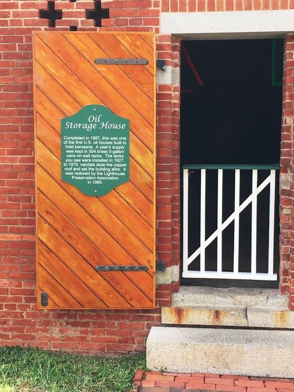
Completed in 1887, this was one of the first U.S. oil houses built to hold kerosene. A year’s supply was kept in 504 brass 5-gallon cans on wall racks. The tanks you see were installed in 1927. In 1970, vandals stole the copper roof and set the . . . — — Map (db m113143) HM
Ponce de Leon Inlet Lighthouse Has Been Designated A National Historic Landmark This site possesses national significance in commemorating the history of the United States of America 1998 National Park Service United States Department of . . . — — Map (db m34434) HM
In 1921, modern plumbing and bathrooms were added to all the dwellings. Water for these was supplied from a well drilled in 1907, which is still located at the rear of the Pump House. (This may also be the site of the original well, dug prior to the . . . — — Map (db m234789) HM
This building was the home of the Station’s Principal Keeper and his family. It also contained the Light Station office and library. The U.S. Lighthouse Service Principal Keepers who served here are:
William R. Rowlinski . . . — — Map (db m234786) HM
Three keepers lived at the Station with their families. The Principal Keeper lived in the largest house, and the First and Second Assistant Keeper lived in the two smaller dwellings. This building was the home of the Second Assistant Keeper and his . . . — — Map (db m112831) HM
In 1921, the Lighthouse Service enclosed portions of the porch on each dwelling at the Light Station in order to install bathroom facilities for the families. A small office room was included in this upgrade when the porch of the Principal Keepers . . . — — Map (db m234790) HM
The Gopher Tortoises living at the Light Station are descendants of tortoises
that have lived here for generations. Several of them are well over 30 years old. These land animals are members of the: reptile family, and dig burrows that can be . . . — — Map (db m112573) HM
In 1884, as part of their preparations to construct the lighthouse, the United States Light-House Establishment installed a tramway to carry supplies to the tower site from the shore of the Halifax River.
The tramway consisted of two iron rails, . . . — — Map (db m173803) HM
Noted lighthouse builder Winslow Lewis began work on the Saint Marks structure in 1829. Eroding shores forced relocation a short distance inland in 1842 to its present location. The adjoining keeper’s house is not original having been rebuilt on . . . — — Map (db m67106) HM
The Cockspur Island Lighthouse, located in front of you was built in 1856. Six years later it was a silent witness to the Battle of Fort Pulaski. On April 10-11, 1862, the lighthouse was located midway between Union forces here on Tybee Island and . . . — — Map (db m19678) HM
Designed and built in 1848 by renowned architect John S. Norris to mark the entrance to the South Channel of the Savannah River, the Cockspur Island Lighthouse was destroyed by a hurricane in 1854. A larger replacement was built on the same . . . — — Map (db m47201) HM
Tybee Lighthouse was re-classified as a major aid to navigation in 1866 and a First-Order Fresnel lens was installed in 1867. The lens, with a height of 9 feet and a 6-foot diameter, has 320 glass prisms. Lard was used to keep the light lit in 1867, . . . — — Map (db m210681) HM
This is the historic cupola that topped the Cockspur Island Lighthouse. The cupola protected the powerful Fresnel lens at the top of the lighthouse tower. In 1995, preservation staff discovered several structural cracks in the cupola and removed it . . . — — Map (db m134077) HM
A lighthouse on Tybee was one of the first public structures in Georgia. Completed in 1736 by William Blithman of cedar piles and brickwork, its 90 foot height made it the loftiest in America. Destroyed
in a storm, it was replaced by another . . . — — Map (db m7423) HM
In 1793 John Couper, with his partner James Hamilton, purchased Cannon's Point in northeastern St. Simons Island. In addition to the production of cotton, Couper experimented with citrus trees, grapes, date palms from Persia, mulberry trees for . . . — — Map (db m30167) HM
In 1804, John Couper of Cannon's Point Plantation sold 4 acres of land, known as Couper's Point, to the U.S. Government for the sum of $1.00. This is the site where the first St. Simons Lighthouse, built by James Gould, was located. — — Map (db m14041) HM
The present lighthouse was
commissioned by the U.S.
Government in 1867 to be
built adjacent to the site of
the 1810 tower. The 104' tower
and keeper's dwelling were
designed by the noted
architect Charles Clusky.
Clusky and . . . — — Map (db m13486) HM
In 1804, Scottish-born plantation owner
John Couper sold four acres of land for $1 to the
new United States government to build the first
St. Simons Light Station. James Gould was hired
to design and build the lighthouse . . . — — Map (db m13463) HM
The Lighthouse and Keeper's Dwelling were completed in 1872, replacing the Lighthouse destroyed during the Civil War. Orlando Poe, chief engineer for the U.S. Lighthouse Board, supervised the design. Charles Cluskey, the architect of many . . . — — Map (db m106303) HM
The Diamond Head Lighthouse is a prominent symbol of Hawaiian
history to residents and visitors alike.
The lighthouse rests aside a tuff-cone volcano, formed by
explosive eruptions thousands of years ago.
In 1825, British sailors ascended the . . . — — Map (db m111324) HM
May the glimmer of both this historic lighthouse, guiding ships to safe harbor, and the legacy of Senator Daniel K. Inouye, illuminating the voices of Hawaii citizens, always continue to serve as beacons of hope.
'Ike vision, Lawelawe . . . — — Map (db m65776) HM
Dedicated to the fight against cancer on 5 November 2014 - Worlds first lighthouse built to help fight cancer
"Where there's light, there's Hope!" — — Map (db m146334) HM
This lighthouse built in 1858 replaced 1837 lighthouse built at water's edge. Remodeled in 1904. Light placed at end of pier. Seven keepers and fourteen assistant keepers served here 1837-1940. — — Map (db m75722) HM
Established on September 1, 1859, this lighthouse stood near the entrance to the Atchafalaya Bay on the Gulf Coast of Louisiana. Its design, one of only two built in the United States of this type, is a square pyramid, fully enclosed in boiler . . . — — Map (db m86405) HM
In this bicentennial year, 1765-1965, of Cape Elizabeth, Maine, the town dedicates this plaque in honor of the United States Coast Guard on the 175th anniversary of its founding and the commissioning of the light by the President of the United . . . — — Map (db m161818) HM WM
"Keepers of the Light"
1791 John K. Greenleaf •
1796 Dave Duncan •
1976 Barzillai Delano •
1820 Joshua Freeman •
1840 Richard Lee •
1849 John F. Watts •
1853 John W. Coolidge •
1854 James S. Williams •
1854 James Delano • . . . — — Map (db m186104) HM WM
Since its commission by George Washington in 1790, Portland Head Light remains an enduring symbol of the rugged, solid characteristics of a magnificent coastline and proud people weathering the challenges of nature and time.
In observance of . . . — — Map (db m41841) HM
Mount Desert Island's coastal waters have always held dangers for boats and ships - rocky shoreline, hidden ledges, and small islands that hide in the fog.
Since 1875, Egg Rock Lighthouse perched on the craggy island before you, has helped . . . — — Map (db m25481) HM
This property has been placed on the National Register of Historic Places by the United States Department of the Interior Bass Harbor Head Light Station 1858 — — Map (db m105405) HM
Maine boasts more than 70 lighthouses – an indication of the over 3,400 miles of shoreline that weaves in and out of craggy cliffs and cobble beaches along this rugged coast. Built on rocky promontories and offshore islands, the lighthouses . . . — — Map (db m105672) HM
Bass Harbor Head Light stands at the southern most tip of Mount Desert Island and marks the entrance to Blue Hill Bay and Bass Harbor. Since 1858 it has warned mariners of navigation hazards along this rocky shore.
In the nineteenth century, the . . . — — Map (db m102500) HM
Land purchased from heirs of
Nathaniel Merryman
by the United States of America
November 22, 1824
Contractors - Jeremiah Berry
Robert Foster, Ballard Green
Beacon Installed - Winslow Lewis
1st Lightkeeper - Isaac Stearns
First . . . — — Map (db m52323) HM
How Did Owl's Head Get Its Name?
For centuries, people have wondered how Owl's Head received its name. According to Native American legend, the head of an owl can be identified in this rocky cliff that the Indians called . . . — — Map (db m52332) HM
(panel 1)
Welcome to Owls Head Light Station
“Owl's Head ushers at once upon a scene almost too beautiful to profane with speech when we are looking at it; impossible to find language to do it justice when memory would . . . — — Map (db m116036) HM
Construction of this 4,300-foot long breakwater began in April 1881. Eighteen years, $750,000 and over 732,277 tons of granite later, it was completed on November 24, 1899. The lighthouse dates from 1902 and was placed on the National Register of . . . — — Map (db m55361) HM
[Historical Excerpt Transcribed]
General Information
The Rockland Harbor Trail is easy to follow. Allow you and your imagination enjoy the Harbor sights along the way. The trail is approximately 5.5. mile[s] from beginning to end, . . . — — Map (db m52340) HM
[Historical Excerpt Transcribed]
General Information
The Rockland Harbor Trail is easy to follow. Allow you and your imagination enjoy the Harbor sights along the way. The trail is approximately 5.5. mile[s] from beginning to end, . . . — — Map (db m55360) HM
[Historical Excerpt Transcribed]
General Information
The Rockland Harbor Trail is easy to follow. Allow you and your imagination enjoy the Harbor sights along the way. The trail is approximately 5.5. mile[s] from beginning to end, . . . — — Map (db m55393) HM
The Oil House was built in 1896 to hold the oil which fueled the lighthouse lamps. A tender would sail as close to the rocks as possible, send a heavy line ashore and transfer the oil. — — Map (db m55449) HM
West Quoddy Head
44°48"9'N 66°57"1'W
Erected by the WQHLKA Inc.
Spring 2005
with permission of the
Maine Department
of Conservation — — Map (db m54818) HM
Erected in 1879 by the United States Light House Service to protect mariners from the "Savage Rock."
Sohier Park
William Davies Sohier
1858-1938
Mr. Sohier generously donated this site of four acres to the York Beach Village Corporation . . . — — Map (db m55593) HM
(Left side of the marker) Much of the early history of Thomas Point still lies buried under sand and water at its ever-eroding shoreline. Evidence does exist, however, that Native Americans enjoyed the bounty of the Bay’s seafood sometime between . . . — — Map (db m94344) HM
First established in 1822 (discontinued in 1855) the Bodkin Island Lighthouse would have been visible to your left in the distance. It has long since crumbled and what remains of the lighthouse and the island on which it stood now show only as a . . . — — Map (db m147648) HM
US Coast Guard Cutter, Taney, the only warship still afloat that saw action during the December 7, 1941 attack on Pearl Harbor, was commissioned in 1936. This 326-foot High Endurance Cutter is one of seven Secretary class ships built. . . . — — Map (db m145465) HM
Seven Foot Knoll Lighthouse was the second screwpile lighthouse built by the U.S. Lighthouse Service. It was originally located 15 miles southeast of here in the Chesapeake Bay, marking the entrance to the Patapsco River and the approach to . . . — — Map (db m145579) HM
Seven-Foot Knoll Lighthouse was the second screwpile lighthouse built by the U.S. Lighthouse Service. It was originally located 15 miles southeast of this location. The 47-foot-high, round, screwpile lighthouse was completed by the Baltimore . . . — — Map (db m219659) HM
Seven-foot knoll lighthouse was the second screwpile structure to be built by the U.S. Lighthouse Service. It was originally located 15 miles southeast of this location. The 42 foot high round screwpile lighthouse was completed by the Baltimore . . . — — Map (db m64732) HM
The best-known and least-appreciated fresh waterway in Baltimore, the Jones Falls River is an important tributary of the Chesapeake Watershed, and the largest of several waterways that empty into Baltimore Harbor. From the time of the first colonial . . . — — Map (db m129001) HM
Built in 1828, the oldest operating lighthouse in Maryland. The prism lens used today was manufactured in Paris and installed in 1897. The original 38-foot tower was built of locally manufactured brick and was raised about 1912 to 51 feet. In 1953 . . . — — Map (db m3440) HM
Sharps Island Lighthouse, one of the cassion-type lighthouses left on the Bay, sits on the sand bar of Tilghman Island. The lighthouse leans to one side because of damage caused by ice in the early 1970's. The sand bar is all that remains of Sharps . . . — — Map (db m138535) HM
This lighthouse, installed in 1883, originally stood 125 yards offshore at the entrance of the Patuxent River to the Chesapeake Bay. The foundation on which the cottage living quarters rest consist of seven wrought iron screw piles, hand bored into . . . — — Map (db m3457) HM
"The necessity of a light at this point is very great, as all vessels bound up or down the Chesapeake put in at this place during the winter to seek protection from floating ice; and as the entrance is formed by a low sand spit, . . . — — Map (db m60232) HM
Screwpile lighthouses like Drum Point get their name from the pilings which were screwed into the seabed to support the lighthouse structure. This cast-iron auger and attached section of wrought-iron pile were recovered from the original site of . . . — — Map (db m138609) HM
"The necessity of a light at this point is very great, as all vessels bound up or down the Chesapeake put in at this place during the winter to seek protection from floating ice; and as the entrance is formed by a low sand spit, which . . . — — Map (db m138607) HM
The Turkey Point Lighthouse stands proudly on a 100-foot bluff looking south over the Chesapeake Bay. Built in 1833, the lighthouse pointed the way to safe waters for nearly 175 years. It played a vital part in protecting the lives and . . . — — Map (db m147746) HM
This historic walk takes you to the Turkey Point Light Station in Maryland's Cecil County. You will find, atop a 100-foot-high bluff, an 1833 tapering conical stucco-covered brick tower and a 1913 cement oil house. This Lighthouse is 31_1/2 feet . . . — — Map (db m147628) HM
What does a lighthouse mean to you? For some, a lighthouse stands for security, providing safe passage home from a treacherous journey. For others, a lighthouse harkens back to a simpler time, before modern technology altered our connection with the . . . — — Map (db m147747) HM
This box-like structure on the outside of the lighthouse represents the outhouse for the lighthouse keepers. In the original lighthouse, the outhouse was an enclosed room that extended out from the wall and across the deck. The unheated privy was . . . — — Map (db m205053) HM
Because the original Choptank River Lighthouse was located two miles off shore, keepers went to work by launch boat, pictured above. We've created a replica of that boat, designed according to blueprints filed with the U.S. National Archives and . . . — — Map (db m205052) HM
Erected at the mouth of the Susquehanna River in 1827, it is the oldest lighthouse in continuous operation in the United States. Now under automatic control, it was manned by the O’neill Family until 1928. John O’neill was named as the first . . . — — Map (db m165000) HM
The original property for the lighthouse Keeper's House included the entire block bounded by Concord Street to the east, Lafayette Street to the south, Alliance Street to the north and Young Street to the west. A fence surrounding the property . . . — — Map (db m164959) HM
On the point where the mighty Susquehanna River meets the Chesapeake Bay stands the lighthouse that protected vessels from dangerous waters for 148 years.
Built in 1827 to protect vessels from dangerous shoals and currents at the mouth of the . . . — — Map (db m164071) HM
Each night he left his house to climb the 27 stairs and 6 rung iron ladder to the top of the lighthouse. And he did this three times a night to refill the oil that kept the light burning and the ships safe.
This is the house of the . . . — — Map (db m164072) HM
1827-1920. Constructed by John Donahoo of Havre de Grace; Builder of Twelve Maryland Lighthouses
The house and property were sold by the U.S.
Government in April 1920 as the light had been automated and a resident keeper was no longer . . . — — Map (db m164821) HM
In 1918, the United States War Department established the Dahlgren Proving Grounds in King George County, Virginia. Military leaders who had observed the death and destruction of World War I wanted more accurate and effective large guns for future . . . — — Map (db m104737) HM
1851 Isaac Wood
1853 George Goddard
1859 Jerome L. McWilliams
1868 Dr. Joseph L. McWilliams
1875 Mrs. Josephine McWilliams Freeman
1912 William M. Freeman, Jr.
1913 Leonard H. Staubly
1917 Francis E. Butterfield, Jr. . . . — — Map (db m24187) HM
The original Blackistone Lighthouse was built in 1851, ten years before the start of the American Civil War. It was constructed by John Donahoo of Havre De Grace, Maryland, under contract with the U.S. Government. In 1932, it was . . . — — Map (db m204928) HM
Rebuilding for future generations. Josephine Mattingly, granddaughter of Mrs. Josephine Freeman, left a bequest to the St. Clement's Hundred, a non-profit group formed to preserve and enhance St. Clement's Island. Fulfilling this promise, the . . . — — Map (db m204931) HM
During the night of May 19, 1864, Confederate Navy Capt. John Goldsmith and a dozen men slipped past a nearby Union Potomac Flotilla gunboat and disembarked here from the 30-foot sloop Swan. They intended to destroy the Blackistone . . . — — Map (db m204935) HM
The original bell tower erected in 1888 included machinery designed to strike every 16 seconds. It served as a vital part of the warning system for ships in inclement weather.
This bell tower was built by Paul Bennett and Jay Pilkerton . . . — — Map (db m204934) HM
A Potomac River landmark, St. Clement's Island has served many functions: a lighthouse site, a summer resort, and farmland. The island became a state park in 1962 and today offers trails, a lighthouse you can explore, wildlife viewing, . . . — — Map (db m204851) HM
On May 19, 1864 Confederates raided St. Clement's Island to destroy the 1851 lighthouse. Capt. John Goldsmith, a county residence who had once owned the island, led the attack, having joined the Confederate army in Virginia. In a thirty-foot . . . — — Map (db m9181) HM
This 62 acre park is the location of the landing of Maryland's first colonists. 150 British settlers, sailing on the Ark and Dove, arrived on the Island on March 25, 1634, which is now commemorated annually as Maryland Day. A . . . — — Map (db m204861) HM
It was April 22, 1865, the eight day of the intense manhunt for President Lincoln's assassin—John Wilkes Booth—across southern Maryland. U.S. Army and Navy detachments were in the chase, including vessels of the Potomac Flotilla, which had helped . . . — — Map (db m204852) HM
Glaciers, storms, tides and winds are constantly creating and destroying islands and shorelines throughout the Chesapeake Bay region. According to Maryland settler and Jesuit missionary Father Andrew White, St. Clement's Island was 400 acres in . . . — — Map (db m24196) HM
Panel 1: Chronology
The Cedar Point Lighthouse marked the southern point of the confluence of the Chesapeake Bay and the Patuxent River during the years from its completion in 1896 until it was abandoned by the Coast Guard in 1928. This . . . — — Map (db m62467) HM
A Chesapeake Landmark Erected in 1896, the Cedar Point Lighthouse marked the southern point of where the Patuxent River and Chesapeake Bay come together. The lighthouse was a three-story brick and frame structure, with its cupola mounted 50 . . . — — Map (db m138622) HM
Protecting ships from treacherous waters has been a necessity since ancient times when bonfires and strategically placed cottage lanterns warned seamen of dangers in fog and darkness. Lighthouses of the Chesapeake and Potomac River waterways are . . . — — Map (db m9011) HM
On Christmas Eve of 1835, land consisting of 2.5 acres was purchased by the Federal Government from William and Charlotte Suter for three hundred dollars. The following year the first lighthouse constructed entirely on the shoreline of the Potomac . . . — — Map (db m94283) HM
In 1861, the U.S. created the Potomac Flotilla (gunboats and other armed vessels) to patrol the river and intercept Confederate blockade runners. Nevertheless, St. Mary's County residents frequently ferried supplies and men across to Virginia. A . . . — — Map (db m188560) HM
On Christmas Eve 1835, the Federal Government purchased 2.5 acres of land from William and Charlotte Suter for $300. A year later the first lighthouse constructed entirely on the shoreline of the Potomac River went into service at Piney Point. . . . — — Map (db m192977) HM
On Christmas Eve 1835, the Federal Government purchased 2.5 acres of land from William and Charlotte Suter for $300. A year later the first lighthouse constructed entirely on the shoreline of the Potomac River went into service at Piney . . . — — Map (db m207241) HM
Most freestanding light houses were accompanied by "keeper's quarters," which housed the light keepers and their families. The Piney Point Lighthouse and keeper's quarters were built in 1836 by John Donahoo of Havre de Grace.
The original . . . — — Map (db m8978) HM
Most freestanding lighthouses were accompanied by "keeper's quarters," which housed the light keepers and their families. The Piney Point Lighthouse and keeper's quarters were built in 1836 by John Donahoo of Havre de Grace, Maryland. . . . — — Map (db m207240) HM
For 136 years, the Point lookout Lighthouse
helped generations of Chesapeake Bay
mariners avoid shoals, navigate through dense
fog, and find the Potomac River’s mouth. The
beam shone until 1966, when an automated light off Point Lookout assumed . . . — — Map (db m104740) HM
1900
Oxford's population is 1243.
The oyster boom ends due to overfishing, pollution, and lack of regulation.
1904
Downtown Baltimore is destroyed by fire.
1910
Red Man's Hall is built on Morris Street as social . . . — — Map (db m204989) HM
Keeper Ulman Owens met an untimely end at the Holland Island Bar Lighthouse in 1931. The official report ruled that he died by natural causes, but his bruised body and a nearby knife made some suspect foul play. We can't be sure this 1,000-pound . . . — — Map (db m138380) HM
The U.S. Lighthouse Establishment built two cottage-style lighthouses in 1892—one in Chesapeake Bay waters at Maryland Point on the Potomac River and one in Sharkfin Shoal on Tangier Sound. Each of these was equipped with not only a lighted beacon, . . . — — Map (db m138377) HM
After the first lighthouse at Janes Island near Crisfield was destroyed by ice in January 1879, a second screwpile lighthouse identical to the one at Hooper Strait (now located on Museum ground) replaced it. Ice struck the Janes Island Light . . . — — Map (db m138379) HM
This lighthouse was originally located forty miles south of here –in Hopper Strait—where its light marked the location of one of the Chesapeake Bay’s many hidden sand bars. Because the Bay is mostly shallow, sailing a boat from the . . . — — Map (db m61486) HM
A screw like this one was at the bottom of each of the seven pilings (legs) of this lighthouse—allowing the leg to be screwed down into the soft Bay bottom. It would have been much easier to simply drive the leg straight down into the mud, but . . . — — Map (db m61491) HM
The hexagonal screwpile cottage-style light station off Thomas Point was lit in 1875, replacing an earlier tower on the shore. In 1914, the US Lighthouse Service noted that Thomas Point Shoal's fog bell sounded a triple stroke every 30 seconds using . . . — — Map (db m138373) HM
Henry McShane started his Baltimore foundry in 1856, and by the late 1800s McShane Bell Foundry employed 90 people and produced tens of thousands of bells and chimes for churches, firehouses, public buildings and fog-alarm bells for lighthouses, . . . — — Map (db m138374) HM
When fog hides a lighthouse’s beacon, sailors need an audible signal to guide them. So a fog tower containing a bell was frequently built alongside a lighthouse. Large bells, such as the 1100 pound bell in this tower, were used because their sound . . . — — Map (db m61483) HM
When fog hides a lighthouse's beacon, sailors need an audible signal to guide them. So a fog tower containing a bell was frequently built alongside a lighthouse. Large bells, such as the 1,100 pound bell in this tower were used because their . . . — — Map (db m138371) HM
603 entries matched your criteria. Entries 101 through 200 are listed above. ⊲ Previous 100 — Next 100 ⊳