603 entries match your criteria. Entries 101 through 200 are listed.⊲ Previous 100 — Next 100 ⊳
Lighthouses Historical Markers
Lighthouses mark dangerous coastlines, hazardous shoals, reefs, rocks, and safe entries to harbors. Once widely used, the number of operational lighthouses has declined due to the expense of maintenance and have become uneconomical since the advent of cheaper electronic navigational systems. Many remain standing due to historic preservation efforts.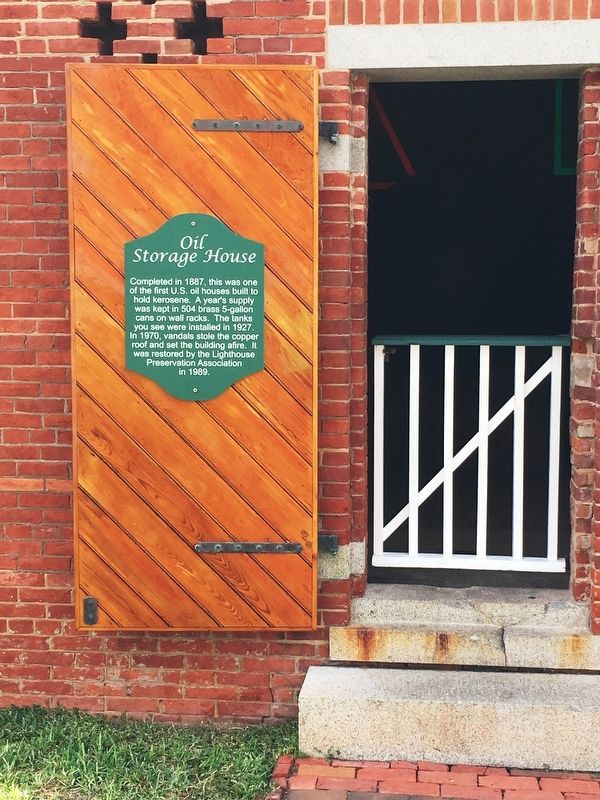
By Brandon D Cross, November 12, 2017
Oil Storage House Marker
| 101 ► Florida, Volusia County, Ponce Inlet — Oil Storage House — Ponce de Leon Inlet Lighthouse & Museum — |
| Near South Peninsula Drive, 0.1 miles south of Ocean Way Drive. | |||
| 102 ► Florida, Volusia County, Ponce Inlet — Ponce de Leon Inlet Lighthouse — |
| On South Peninsula Drive south of Ocean Way Drive, on the left when traveling south. | |||
| 103 ► Florida, Volusia County, Ponce Inlet — Porch Restoration — Ponce de Leon Inlet Lighthouse & Museum — |
| Near South Peninsula Drive, 0.1 miles west of Lighthouse Drive. | |||
| 104 ► Florida, Volusia County, Ponce Inlet — Principal Keeper's Dwelling — |
| Near South Peninsula Drive, 0.2 miles south of Ocean Way Drive, on the left when traveling south. | |||
| 105 ► Florida, Volusia County, Ponce Inlet — Second Assistant Keeper's Dwelling — Ponce de Leon Inlet Lighthouse & Museum — |
| Near on South Peninsula Drive, 0.1 miles Ocean Way Drive. | |||
| 106 ► Florida, Volusia County, Ponce Inlet — The Principal Keeper's Office — Ponce de Leon Inlet Lighthouse & Museum — |
| Near South Peninsula Drive, 0.1 miles south of Ocean Way Drive, on the left when traveling south. | |||
| 107 ► Florida, Volusia County, Ponce Inlet — The Southern Gopher Tortoise — |
| Near South Peninsula Drive, 0.2 miles south of Ocean Way Drive, on the left when traveling south. | |||
| 108 ► Florida, Volusia County, Ponce Inlet — The Tramway — Ponce de Leon Inlet Lighthouse & Museum — |
| Near South Peninsula Drive, 0.1 miles west of Lighthouse Drive. | |||
| 109 ► Florida, Wakulla County, St. Marks — F-207 — St. Marks Lighthouse — |
| On Lighthouse Road, 10 miles south of Coastal Highway (U.S. 98) when traveling south. | |||
| 110 ► Georgia, Chatham County, Tybee Island — Cockspur Island Lighthouse — |
| Near Islands Expressway (U.S. 80) near Catalina Drive, on the right when traveling west. | |||
| 111 ► Georgia, Chatham County, Tybee Island — 25-41 — Cockspur Island Lighthouse — |
| 112 ► Georgia, Chatham County, Tybee Island — First Order Fresnel Lense — |
| On Meddin Drive, on the right when traveling south. | |||
| 113 ► Georgia, Chatham County, Tybee Island — Sheltering Crown — Fort Pulaski National Monument — |
| On Fort Pulaski Road, 0.9 miles north of U.S. 80, on the right when traveling north. | |||
| 114 ► Georgia, Chatham County, Tybee Island — 25-59 — Tybee Lighthouse — ← — |
| On Meddin Drive, on the left when traveling north. | |||
| 115 ► Georgia, Glynn County, St. Simons Island — 63-9 — Cannon's Point Plantation — |
| On Lawrence Road, 3 miles north of Frederica Road, on the right when traveling north. | |||
| 116 ► Georgia, Glynn County, St. Simons Island — Couper's Point — |
| 117 ► Georgia, Glynn County, St. Simons Island — Historic St. Simons Lighthouse — |
| On 12th Street, on the right when traveling south. | |||
| 118 ► Georgia, Glynn County, St. Simons Island — Keepers of the Light — |
| On 12th Street, on the right when traveling south. | |||
| 119 ► Georgia, Glynn County, St. Simons Island — The First Lighthouse ~ 1810 — |
| On 12th Street, on the right when traveling south. | |||
| 120 ► Georgia, Glynn County, St. Simons Island — Welcome to St. Simons Light! — |
| On 12th Street south of Beachview Drive, on the right when traveling south. | |||
| 121 ► Hawaii, Honolulu County, Honolulu, Waialae - Kahala — Diamond Head Lighthouse — |
| On Diamond Head Rd, on the right when traveling north. | |||
| 122 ► Hawaii, Kauai County, Kilauea — Daniel K. Inouye — Kilauea Point Lighthouse — |
| Near Kilauea Road, 1.8 miles north of Hawaii Route 56. | |||
| 123 ► Illinois, Cook County, Evanston — Grosse Point Light Station — |
| On Sheridan Road, on the right when traveling north. | |||
| 124 ► Illinois, Massac County, Metropolis — Hope Light — |
| Near East Front Street. | |||
| 125 ► Indiana, LaPorte County, Michigan City — Michigan City Lighthouse — |
| Near Lake Shore Drive, 0.1 miles west of Franklin Street. | |||
| 126 ► Louisiana, St. Mary Parish, Berwick — Southwest Reef Lighthouse — |
| Near Bellview Front Street at Lima Street, on the right when traveling north. | |||
| 127 ► Maine, Cumberland County, Cape Elizabeth — Coast Guard Day — Aug. 4, 1965 — |
| On Shore Road, on the right when traveling north. | |||
| 128 ► Maine, Cumberland County, Cape Elizabeth — Lighthouse Bicentennial — 1789 - 1989 Portland Head Light — |
| Near Shore Road south of Littlejohn Road, on the right when traveling north. | |||
| 129 ► Maine, Cumberland County, Cape Elizabeth — Looking East — Casco Bay — |
| 130 ► Maine, Cumberland County, Cape Elizabeth — Portland Head Light — |
| On Fort Williams Park. | |||
| 131 ► Maine, Cumberland County, South Portland — Spring Point Ledge Light — |
| On Lighthouse Circle at Fort Road, on the right when traveling east on Lighthouse Circle. | |||
| 132 ► Maine, Hancock County, Bar Harbor — Acadian Lights — |
| On Ocean Drive, on the right. | |||
| 133 ► Maine, Hancock County, Bass Harbor — Bass Harbor Head Light Station — 1858 — |
| Near Lighthouse Road, on the left when traveling south. | |||
| 134 ► Maine, Hancock County, Bass Harbor — Mariners Beware! — Acadia National Park — National Park Service, U.S. Department of the Interior — |
| Near Lighthouse Road. | |||
| 135 ► Maine, Hancock County, Tremont — A Steadfast Light — |
| On Lighthouse Road. | |||
| 136 ► Maine, Knox County, Owl's Head — Owl's Head Light — |
| 137 ► Maine, Knox County, Owl's Head — Owl's Head Light Station — |
| 138 ► Maine, Knox County, Owl's Head — Welcome to Owls Head Light Station — |
| Near Lighthouse Road, 0.4 miles north of Dodge Point Lane, on the right when traveling north. | |||
| 139 ► Maine, Knox County, Rockland — Rockland Breakwater Lighthouse — |
| 140 ► Maine, Knox County, Rockland — Rockland Harbor Trail — Snow Marine Park to Rockland Breakwater Light — |
| On Main Street (Maine Route 73) near Myrtle Street, on the right when traveling north. | |||
| 141 ► Maine, Knox County, Rockland — Rockland Harbor Trail — Snow Marine Park to Rockland Breakwater Light — |
| 142 ► Maine, Knox County, Rockland — Rockland Harbor Trail — Snow Marine Park to Rockland Breakwater Light — |
| On Main Street (U.S. 1), on the right when traveling north. | |||
| 143 ► Maine, Lincoln County, New Harbor — Oil House — |
| 144 ► Maine, Lincoln County, New Harbor — Pemaquid Point Lighthouse — |
| On Pemaquit Loop Road. | |||
| 145 ► Maine, Washington County, Lubec — Easternmost Point in the U.S.A. — |
| 146 ► Maine, York County, York — "Nubble Light House" — Cape Neddick Light Station — U.S. Coast Guard — |
| On Sohier Park Rd, 0.1 miles Nubble Rd, on the right when traveling east. | |||
| 147 ► Maryland, Anne Arundel County, Highland Beach — Thomas Point — Part Of The Bay Heritage — |
| On Thomas Point Road. | |||
| 148 ► Maryland, Anne Arundel County, Pasadena — A Lighthouse Crumbles — Downs Park History Moment — |
| On Chesapeake Bay Drive, 0.6 miles north of John Downs Loop, on the right when traveling north. | |||
| 149 ► Maryland, Baltimore, Inner Harbor — Historic Ships in Baltimore — "Walk the Decks of History!" — Baltimore Maritime Museum — |
| On Harbor Bridge Walk, 0.1 miles south of East Pratt Street, on the right when traveling south. | |||
| 150 ► Maryland, Baltimore, Inner Harbor — Seven Foot Knoll Lighthouse |
| Near Eastern Avenue, 0.1 miles west of President Street when traveling west. Reported permanently removed. | |||
| 151 ► Maryland, Baltimore, Inner Harbor — Seven Foot Knoll Lighthouse — |
| On Pier 5 south of Eastern Avenue when traveling west. | |||
| 152 ► Maryland, Baltimore, Inner Harbor — Seven-Foot Knoll Lighthouse |
| Near Eastern Avenue. Reported permanently removed. | |||
| 153 ► Maryland, Baltimore, Inner Harbor — Water Power: Baltimore's Economic Engine — Jones Falls Trail and the Seven Foot Knoll Lighthouse |
| On Eastern Avenue at East Falls Avenue on Eastern Avenue. Reported damaged. | |||
| 154 ► Maryland, Calvert County, Lusby — Cove Point Lighthouse — 3.4 miles — |
| On Cove Point Road (Maryland Route 497) 3.4 miles east of Solomons Island Road (Route 2 / 4) when traveling east. | |||
| 155 ► Maryland, Calvert County, North Beach — Sharps Island Lighthouse — |
| On Atlantic Avenue just south of 7th Street, on the right when traveling north. | |||
| 156 ► Maryland, Calvert County, Solomons — Drum Point Lighthouse — 1883-1962 — |
| On Solomons Island Road (Maryland Route 2) 0.1 miles south of Lore Road, on the left when traveling south. | |||
| 157 ► Maryland, Calvert County, Solomons — Drum Point Lighthouse |
| On Solomons Island Road, South. Reported permanently removed. | |||
| 158 ► Maryland, Calvert County, Solomons — The Business End of a Screwpile — |
| Near Solomons Island Road South (Maryland Route 2) just south of Thomas Johnson Road, on the left when traveling south. | |||
| 159 ► Maryland, Calvert County, Solomons — Welcome to Drum Point Lighthouse — |
| Near Solomons Island Road South (Maryland Route 2) just south of Thomas Johnson Road, on the left when traveling south. | |||
| 160 ► Maryland, Cecil County, North East — Sentinel on the Bay — |
| On Turkey Point Road (Maryland Route 272). | |||
| 161 ► Maryland, Cecil County, North East — Welcome to Turkey Point! — |
| Near Turkey Point Lighthouse Trail. | |||
| 162 ► Maryland, Cecil County, North East — Why Build a Lighthouse? — |
| On Turkey Point Road (Maryland Route 272). | |||
| 163 ► Maryland, Dorchester County, Cambridge — Privy Station — |
| Near High Street north of Water Street when traveling north. | |||
| 164 ► Maryland, Dorchester County, Cambridge — The Launch Boat — |
| Near High Street north of Water Street when traveling north. | |||
| 165 ► Maryland, Harford County, Havre de Grace — Concord Point Lighthouse — Havre de Grace, Md. |
| On Concord Street at Lafayette Street, on the left on Concord Street. Reported missing. | |||
| 166 ► Maryland, Harford County, Havre de Grace — Concord Point Lighthouse Grounds — |
| 167 ► Maryland, Harford County, Havre de Grace — Dangerous Waters — |
| On Concord Street at Lafayette Street, on the left when traveling south on Concord Street. | |||
| 168 ► Maryland, Harford County, Havre de Grace — Keeper of the Light — |
| On Concord Street at Lafayette Street on Concord Street. | |||
| 169 ► Maryland, Harford County, Havre de Grace — The Concord Point Light Keeper’s House and Property, 1827-1920 — |
| On Concord Street at Lafayette Street, on the right on Concord Street. | |||
| 170 ► Maryland, St. Mary's County, Coltons Point — A Target for Big Guns |
| Near Point Breeze Road, 0.2 miles east of Colton Point Road (Maryland Route 242). Reported permanently removed. | |||
| 171 ► Maryland, St. Mary's County, Coltons Point — Blackistone Island Lighthouse — Keepers of the Light |
| Near Point Breeze Road, 0.2 miles east of Colton Point Road (Maryland Route 242). Reported permanently removed. | |||
| 172 ► Maryland, St. Mary's County, Coltons Point — Blackistone Lighthouse — Witness to History — |
| 173 ► Maryland, St. Mary's County, Coltons Point — Blackistone Lighthouse — Rebuilding a Landmark — |
| 174 ► Maryland, St. Mary's County, Coltons Point — Blackistone Lighthouse — Saved by Keeper's Pregnant Wife — |
| 175 ► Maryland, St. Mary's County, Coltons Point — Blackistone Lighthouse Bell Tower — |
| 176 ► Maryland, St. Mary's County, Coltons Point — Journey to an Island — St. Clement's Island State Park — |
| On Point Breeze Road, 0.1 miles east of Colton Point Road, on the left when traveling east. | |||
| 177 ► Maryland, St. Mary's County, Coltons Point — St. Clement's Island Lighthouse — "None of the Lighthouses … are Safe" |
| On Point Breeze Road, 0.2 miles east of Colton Point Road (Route 242), on the left when traveling east. Reported permanently removed. | |||
| 178 ► Maryland, St. Mary's County, Coltons Point — St. Clement's Island State Park — Information about St. Clement's Island — …where fun comes naturally — |
| 179 ► Maryland, St. Mary's County, Coltons Point — The Black Diamond Incident — "Out of the frying pan into the fire" — |
| On Point Breeze Road, 0.1 miles east of Colton Point Road, on the left when traveling east. | |||
| 180 ► Maryland, St. Mary's County, Coltons Point — The Shrinking Island |
| Near Point Breeze Road, 0.2 miles east of Colton Point Road (Maryland Route 242). Reported permanently removed. | |||
| 181 ► Maryland, St. Mary's County, Lexington Park — Cedar Point Lighthouse — |
| Near Three Notch Road (Maryland Route 235) north of Pegg Road/Burse Rd., on the right when traveling east. | |||
| 182 ► Maryland, St. Mary's County, Lexington Park — Cedar Point Lighthouse Cupola (1896) — |
| Near Three Notch Road (Maryland Route 235) just north of Buse Road, on the right when traveling north. | |||
| 183 ► Maryland, St. Mary's County, Piney Point — Bay Lights — |
| On Lighthouse Road. | |||
| 184 ► Maryland, St. Mary's County, Piney Point — Piney Point Lighthouse — |
| On Lighthouse Road (SR 498). | |||
| 185 ► Maryland, St. Mary's County, Piney Point — Piney Point Lighthouse — The Potomac Flotilla |
| Near Lighthouse Road (County Route 498) 1.4 miles east of Piney Point Road (County Route 249), on the left when traveling east. Reported permanently removed. | |||
| 186 ► Maryland, St. Mary's County, Piney Point — Piney Point Lighthouse — A Mariner's Beacon |
| On Lighthouse Road. Reported permanently removed. | |||
| 187 ► Maryland, St. Mary's County, Piney Point — Piney Point Lighthouse — A Mariner's Beacon — |
| On Lighthouse Road (Maryland Route 498) south of Hotel Cove Lane, on the left when traveling south. | |||
| 188 ► Maryland, St. Mary's County, Piney Point — The Lighthouse Keeper's Quarters |
| On Lighthouse Road. Reported permanently removed. | |||
| 189 ► Maryland, St. Mary's County, Piney Point — The Lighthouse Keeper's Quarters — |
| On Lighthouse Road (Maryland Route 498) south of Hotel Cove Lane, on the left when traveling south. | |||
| 190 ► Maryland, St. Mary's County, Scotland — Let There Be Light — Point Lookout State Park — Maryland Park Service — |
| On Point Lookout Road, at its southernmost tip (Maryland Route 5), on the right when traveling north. | |||
| 191 ► Maryland, Talbot County, Oxford — 1900-1950: Holding On — The Oxford Museum — A Special Place; A Special Heritage — |
| Near South Morris Street at Market Street, on the right when traveling north. | |||
| 192 ► Maryland, Talbot County, St. Michaels — For Whom the Bell Tolls — Chesapeake Bay Maritime Museum — |
| On Mill Street east of Burns Street. | |||
| 193 ► Maryland, Talbot County, St. Michaels — Heard Through the Fog — Chesapeake Bay Maritime Museum — |
| On Mill Street east of Burns Street, on the right when traveling east. | |||
| 194 ► Maryland, Talbot County, St. Michaels — Hooper Straight Light's Twin — Chesapeake Bay Maritime Museum — |
| On Mill Street just east of Burns Street, on the right when traveling east. | |||
| 195 ► Maryland, Talbot County, St. Michaels — Hooper Strait Lighthouse — Chesapeake Bay Maritime Museum |
| On Mill Street east of Burns Street, on the right when traveling east. Reported damaged. | |||
| 196 ► Maryland, Talbot County, St. Michaels — How the Screwpile Lighthouse Got Its Name — |
| On Mill Street. | |||
| 197 ► Maryland, Talbot County, St. Michaels — Iconic Chesapeake Light — Chesapeake Bay Maritime Museum — |
| On Mill Street east of Burns Street, on the right when traveling east. | |||
| 198 ► Maryland, Talbot County, St. Michaels — Last Bell Foundry — Chesapeake Bay Maritime Museum — |
| On Mill Street east of Burns Street, on the right when traveling east. | |||
| 199 ► Maryland, Talbot County, St. Michaels — Point Lookout Fog Bell Tower — Chesapeake Bay Maritime Museum |
| On Mill Street. Reported permanently removed. | |||
| 200 ► Maryland, Talbot County, St. Michaels — Point Lookout Fog Bell Tower — |
| On Mill Street just east of Burns Street, on the right when traveling east. | |||
603 entries matched your criteria. Entries 101 through 200 are listed above. ⊲ Previous 100 — Next 100 ⊳