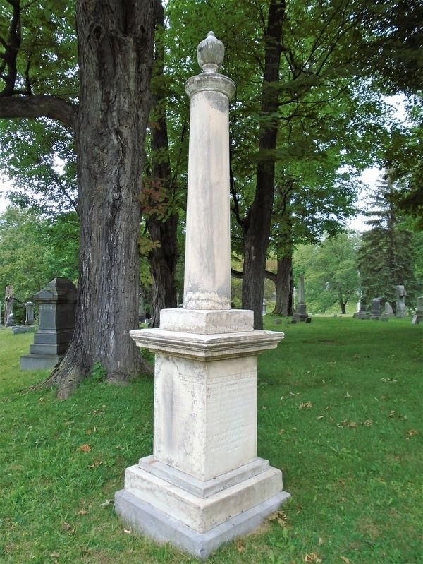
Senior Chief Engineer
of the New York Canals
His public history may be found
in the history of the General
and State Goverments;
His private [virtues?] in the memory
of his acquaintances
Born in Pennsylvania
July 22, 1763. . . . — — Map (db m181134) HM
On Central Avenue (Ohio Route 122) at N. Verity Parkway (Ohio Route 73), on the right when traveling west on Central Avenue.
Canals were built in Ohio to provide a better way to transport goods to the eastern markets. Two major canals were built connecting the Ohio River to Lake Erie - the Ohio Erie & [sic Ohio & Erie] Canal running from Portsmouth to Cleveland and the . . . — — Map (db m30375) HM
On Whitewoman Street, on the left when traveling north.
James LeRetilley Sr. purchased the building in 1849, a year before his death. In 1825, he moved to Caldersburgh from Muskingum County and opened a general store. He was the first postmaster in Caldersburgh (1826). After the canal opened, LeRetilley . . . — — Map (db m27381) HM
Near Valley Parkway east of Riverview Road, on the left when traveling east.
The Ohio & Erie Canalway celebrates the first 110 miles of a waterway that helped the nation grow.
Dug by hand from 1825 to 1832, the Ohio & Erie Canal was the first canal west of the Appalachian Mountains. It connected Lake Erie to the Ohio . . . — — Map (db m224609) HM
Near Ohio & Erie Canal Towpath Trail south of West Aurora Road (Ohio Route 82), on the right when traveling west.
Restoring the Cuyahoga as a healthy, free-flowing river has many challenges. A major goal is removing dams that block fish migrations and degrade natural wildlife habitats. Here two dams diverted water into this section of the Ohio & Erie Canal, . . . — — Map (db m228495) HM
On Ohio & Erie Canal Towpath Trail, on the left when traveling south.
For generations, two families have made their livlihoods in the gristmill at Lock 37. The Alexander family built the mill about 1853 to grind wheat into flour. Water from Lock 37’s spillway turned the mill’s wooden waterwheel and grindstones. In the . . . — — Map (db m202347) HM
On Ohio & Erie Canal Towpath Trail, on the right when traveling south.
Canal Engineers did not foresee the intensity of valley floods and later added structures to control water levels. Here a National Park Service worker adjusts a floodgate built in the early 1900s. Look closely at the actual structure. Can you see . . . — — Map (db m202345) HM
On Ohio & Erie Canal Towpath Trail, on the left when traveling south.
Canal locks attracted businesses to serve canal boat crews, locals, and farmers. Here at Lock 37 the Vanouceks ran a tavern and general store, and the Alexander family operated a gristmill. A spillway allowed excess water to flow around the lock. . . . — — Map (db m202342) HM
Near Hillside Road at Canal Road, on the left when traveling west.
Hi, I’m Blossom. During the canal days.mules like me
walked the towpath, pulling heavy boats behind us. We
were strong engines, able to haul 60 tons or more of
freight. Mules worked in teams of two or three. Cargo
boats had a middle cabin to . . . — — Map (db m140592) HM
James Abram Garfield, 20th President of the United States, was born here in 1831. His father died when he was two, but the family remained on the farm where James helped when he was not attending school. He continued to live here through his years . . . — — Map (db m118214) HM
On Ohio & Erie Canal Towpath Trail, on the left when traveling south.
Stephen and Mehitable Frazee experience both the challenges and benefits of the Ohio & Erie Canal. They arrived in this area in the early 1800s, when it was sparsely settled. They lived in a log cabin, cleared forests for farmland, and were mostly . . . — — Map (db m202332) HM
Near Valley Parkway, on the left when traveling east.
You are on the historic Station Road Bridge facing the Pinery Narrows, the Cuyahoga Valley’s thinnest point. Here the river is confined by hard, deeply cut bedrock. Its path is narrower and straighter than where it twists through loose glacial . . . — — Map (db m202248) HM
Near Station Road, on the left when traveling east.
The first steam engine chugged its way down the new Valley Railway in 1880, beginning an era of progress for the Cuyahoga Valley. Regional industrial growth boosted demand for coal and other raw materials. The railway connected mineral fields in the . . . — — Map (db m202330) HM
This house reflects Stephen and Mehitable Frazee’s transition from being subsistence pioneers to successful farmers. They may have come to the Cuyahoga Valley as tenant farmers as early as 1811. Within 10 years they were able to buy more than 600 . . . — — Map (db m202331) HM
Near Ohio & Erie Canal Towpath Trail at Hillside Road.
Lock 38 is one of the few restored, working locks
along the historic Ohio & Erie Canal. Locks are like
elevators – they raise and lower boats between levels.
State engineers designed 44 locks to deal with a 395 foot
rise in elevation from . . . — — Map (db m140161) HM
On East Edison Drive, on the right when traveling south.
Edison Recalls Milan
My recollections of Milan are somewhat scanty as I left the town when I was not quite seven years old. I remember the wheat elevators on the canal, and Gay shipyard; also the launching of new boats, on which occasion the . . . — — Map (db m90659) HM
On West Market Street (Ohio Route 256) at West Water Street, on the right when traveling east on West Market Street.
The Ohio & Erie Canal and the "Twin Cities"
On this site the Ohio & Erie Canal flowed south and down-level under the Market Street Bridge. Nearby Pawpaw Creek and the canal culturally divided the Swiss settlers to the west in Basil and the . . . — — Map (db m183071) HM
On Center Street just north of Canal Street, on the left when traveling east.
Canals were an important means of transportation when Carroll was founded in 1829 by William Tong and his brother Oliver, who chose this site because it was where the proposed intersection of the Lancaster Lateral Canal and Ohio-Erie Canal would be . . . — — Map (db m80624) HM
On South High Street, on the right when traveling north.
[Marker Front]:
You are standing on the site of Ohio and Erie Canal. The canal helped to open the interior of Ohio to trade and settlement and played a part in Winchester's prosperity during the mid-1800s. Local farmers exported grain from . . . — — Map (db m12530) HM
On Wilt Road, 0.1 miles west of Walnut Street, on the right when traveling east.
Built on Main Street, circa 1815, this two story log residence was later sided. In 1974 during new post office site preparation, the log structure was discovered and moved to present location along Ohio-Erie Canal route. In adjoining Groveport . . . — — Map (db m12521) HM
On Blacklick Street, 0.2 miles Front Street, on the right when traveling east.
Ohio and Erie Canal in Groveport
The Ohio and Erie Canal was Ohio's solution to the lack of a reliable and fast transportation system to move goods to outside markets. The canal opened in the then unplatted village of Groveport on September 25, . . . — — Map (db m12659) HM
Near Groveport Road, on the right when traveling west.
The Ohio and Erie Canal Lock 22, constructed from 1830-1831, is the only canal lock in Groveport. Constructed by W.H. Richardson as part of his $2,937 bid to build section 52 of the canal, the sandstone lock is 117 feet long and ten feet deep and . . . — — Map (db m13724) HM
On Commerce Street at Denny Street, on the right when traveling west on Commerce Street.
Ohio-Erie Canal and Locks
The Ohio-Erie Canal was built between 1825 and 1832 and extended 308 miles from Lake Erie at Cleveland to the Ohio River at Portsmouth. The greatest engineering achievement in Ohio up to that time, the canal gave . . . — — Map (db m12902) HM
On Walnut Road (Ohio Route 79) at Cottage Street, on the right when traveling east on Walnut Road.
[Marker Front]:
Formed by the retreating glacier more than 14,000 years ago, Buckeye Lake first existed as a shallow, swampy pond, named "Buffalo Swamp" by Ohio Company explorer Christopher Gist in 1751. Beginning in 1826 the State . . . — — Map (db m183075) HM
On Hebron Road (Ohio Route 79) near Coffman Boulevard, on the right when traveling north.
At this site on July 4, 1825, Governor DeWitt Clinton of New York turned the first shovelful of dirt for the Ohio Canal. The ceremony was attended by area citizens of Master Masons.
In the early 1840’s James A. Garfield, who was to become the . . . — — Map (db m2377) HM
Where the Water Met the Road
While the citizens of St. Clairsville, in eastern Ohio, celebrated the groundbreaking for the National Road on July 4, 1825, construction began on the Ohio & Erie Canal on the same day at Licking Summit (now . . . — — Map (db m97542) HM
On Main Street (U.S. 40) at Basin Street, on the right when traveling west on Main Street.
Located at the crossing of the Ohio and Erie Canal and the National Road, Hebron was a favored commercial and agricultural center for Licking County in the nineteenth century. Only four miles north of the city Governor DeWitt Clinton of New York . . . — — Map (db m13878) HM
On East Main Street National Road (U.S. 40) at Basin Street, on the right when traveling west on East Main Street National Road.
The village of Hebron lost its first mill to a fire in 1881. By the mid 1880’s, a new mill took its place and continued operation into the 1990’s, making it the longest running business in Hebron. by 1891, the Hebron Mill converted from water power . . . — — Map (db m97543) HM
On Main Street (U.S. 40) at Basin Street, on the right when traveling west on Main Street.
The Hebron Milling Company building was built in 1880 where the National Trail (Route 40) and the Ohio Canal crossed in the village of Hebron. The building sat on the edge of the “turning basin” in the village, where canal boats docked to load or . . . — — Map (db m13879) HM
On East Canal street just east of South 3rd Street, on the right when traveling east.
The preserve is rich in natural as well as early Ohio history. The name, Blackhand, originated from a dark hand-shaped Indian petroglyph which was engraved on the face of a massive sandstone cliff along the north side of the river. The engraving was . . . — — Map (db m205963) HM
On South 2nd Street at East Market Street, on the right when traveling north on South 2nd Street.
Making the final leg of her journey on the Ohio & Erie Canal in 1840, sixteen-year-old Ellen Snell traveled 4,000 miles from her home in England to a country totally foreign to her. The Snell family were like many immigrants before and after . . . — — Map (db m206030) HM
Construction of the Ohio and Erie Canal began on July
4, 1825. Once completed, the canal ran between
Portsmouth on the Ohio River and Cleveland on Lake
Erie. The canal's route through Newark connected the
city to the far boundaries of the state . . . — — Map (db m205957) HM
On South 2nd Street at East Market Street, on the right when traveling north on South 2nd Street.
James Birkey could clearly see that the importance of the Ohio and Erie Canal was being eclipsed elsewhere by newly-built railroad lines. His foresight led him to recognize that without a railroad connection of its own, Newark would cease to be . . . — — Map (db m206032) HM
On South 1st Street north of East Canal Street, on the right when traveling north.
The Ohio & Erie Canal Park is dedicated to the life and memory of Joseph M. Bowden, 1957-2012.
The Works was created from the vision and resources of Howard B. LeFevre and the physical facilities were made possible by the tireless efforts of . . . — — Map (db m206044) HM
On South 2nd Street at East Market Street, on the left when traveling south on South 2nd Street.
Welcome to the Streetscape & History Walk In 1881, Reinhard Scheidler built a new factory building at SS S. 1st Street for his business, the Scheidler Machine Works. Today, that building houses our museum. Scheidler built many types of machinery, . . . — — Map (db m206025) HM
On Ohio Route 104, 0.1 miles north of Simpson Road, on the right when traveling south.
Locks 48 and 49
Rush Township, Ohio
The Ohio & Erie Canal under construction in this area 1830-1832 would cross the farm of George Herodth, a stone contractor. He built the Elbow Lock, Camp Creek Culvert and more. While the canal was being . . . — — Map (db m230148) HM
On Front Street west of Court Street, on the right when traveling west. Reported permanently removed.
Stagecoach
Prior to the advent of railroads, Portsmouth was a hub for stagecoach transportation, maintaining regular schedules to various surrounding towns. In 1830, a trip on the Portsmouth and Columbus turnpike took 18 hours in good . . . — — Map (db m165688) HM
On Front Street just west of Court Street, on the right when traveling west.
Stagecoach
Prior to the advent of railroads, Portsmouth was a hub for stagecoach transportation, maintaining regular schedules to various surrounding towns. In 1830, a trip on the Portsmouth and Columbus turnpike took 18 hours in good weather . . . — — Map (db m166250) HM
Near Erie Avenue NW, 0.1 miles east of Millfield Road NW.
Sounds of boat horns and brawling packet crews resounded for many years at this lock and 142 others on the Ohio and Erie Canal. The canal was a 308-mile water toll road built between 1825 and 1832 from Lake Erie at Cleveland to the Ohio River at . . . — — Map (db m68688) HM
Near Boston Mills Road, on the right when traveling east.
The village of Boston grew up along the Cuyahoga River. After the Ohio & Erie Canal opened in 1827, the community boomed with boatyards and businesses serving canal traffic. The Valley Railway opened in 1880 and spurred construction of the . . . — — Map (db m202357) HM
On Boston Mills Road at Ohio & Erie Canal Towpath Trail, on the left when traveling east on Boston Mills Road.
The size and shape of a canal boat is determined by the smallest lock. Along the Ohio & Erie Canal the smallest is 75 feet long by 15 feet wide.
Workers begin building a boat by laying the keel. Made from white oak timbers, the keel forms . . . — — Map (db m202373) HM
On Boston Mills Road at Ohio & Erie Canal Towpath Trail, on the left when traveling east on Boston Mills Road.
William Barnhart and James Fayerweather’s boatyard is humming with activity. Shipwrights enclose the hull of a canal boat with white-oak boards from Julius Edson’s sawmill and lumberyard. The blacksmith, R. Darmer, makes deadeye rings for canal . . . — — Map (db m202372) HM
On Boston Mills Road at Ohio & Erie Canal Towpath Trail, on the right when traveling east on Boston Mills Road.
Boston’s economy boomed building canal boats. Later it shifted to making toy marbles and then paper. If you were standing here in the early 1900s, the photo below shows what you would have seen. Across the Cuyahoga River stood the Cleveland-Akron . . . — — Map (db m202378) HM
On Boston Mills Road at Ohio & Erie Canal Towpath Trail, on the right when traveling west on Boston Mills Road.
Boston and its citizens experienced booms and busts. Entrepreneur Julius Edson built a business empire that included a sawmill, a gristmill, and major land parcels. By 1856 he also had gained a controlling interest in the 20-year-old Boston Land . . . — — Map (db m202374) HM
Near Boston Mills Road at Ohio & Erie Canal Towpath Trail, on the right when traveling east.
The Ohio & Erie Canalway celebrates the first 110 miles of a waterway that helped the nation grow.
Dug by hand from 1825 to 1832, the Ohio & Erie Canal was the first canal west of the Appalachian Mountains. It connected Lake Erie to the Ohio . . . — — Map (db m202381) HM
Near Boston Mills Road at Ohio & Erie Canal Towpath, on the right when traveling east.
Since the 1800s, the Cuyahoga Valley has been a place where people from nearby cities relax in nature. Building on this tradition, locals worked tirelessly to preserve what is now Cuyahoga Valley National Park. Created in 1974, the park protects . . . — — Map (db m202382) HM
On Riverview Road, on the left when traveling north.
After the Ohio & Erie Canal opened, a tavern and store sprung up south of here to serve boat crews. By the mid-1800s, 40 to 50 boats were passing through nearly every day. The community expanded. A rival store, hotel, blacksmith shop, warehouse, and . . . — — Map (db m203429) HM
On Riverview Road, on the left when traveling north.
Most valley families pieced together a living, earning income in different ways. In the mid to late 1800s the Botzums were the most prosperous family in the area. John August Botzum owned a canal boat, sawmill, general store, and farm. He and his . . . — — Map (db m203428) HM
Near Ohio & Erie Canal Towpath Trail just north of West Aurora Road (Ohio Route 82), on the right when traveling north.
"The dam and feeder are said to be in good condition. This furnishes all the extra water needed between this point and Cleveland … and has always been ample." Ohio Canal Division Reports, 1880
Soon after this canal . . . — — Map (db m228496) HM
On Ohio & Erie Canal Towpath Trail, 0.1 miles north of West Aurora Road (Ohio Route 82), on the right when traveling north.
Soil washing into the canal created an ongoing problem. Storms eroded upland fields and hillsides left treeless by farmers. Engineers usually built culverts under the canal to carry streams into the Cuyahoga River. Here the intermittent Galley . . . — — Map (db m228497) HM
For thousands of years, Native Americans followed a north-south trade route through here. The Cuyahoga River allowed travel by canoe to an eight-mile portage trail to the south-flowing Tuscarawas River, which eventually led to the Ohio River. . . . — — Map (db m183610) HM
On Everett Road, 0.2 miles south of Oak Hill Road, on the right when traveling east.
The reconstructed Everett Covered Bridge stands as a
reminder of a common 19th-century Ohio scene. While its
original date of construction is uncertain, it is patterned on
the 1869 Smith Truss design. In the 19th century, Ohio led
the nation . . . — — Map (db m166145) HM
Near Mill Street West north of North Locust Street, on the left when traveling north.
This model shows a boat that has entered Lock 29 from the north. It is heading south – upstream – towards Akron. Most locks were 90 feet long from gate to gate. Walls were 15 feet apart. Boats were up to 75 feet long and up to 14 feet side, so . . . — — Map (db m202438) HM
Near Riverview Road (County Road 9) south of Major Road, on the right when traveling north.
For over 100 years, these quarries were a source of sandstone prized for its fine quality. Deep Lock Quarry Metro Park’s name is a nod to Lock 28, a stop along the Ohio & Erie Canal where untold tons of stone were shipped to form Akron’s buildings, . . . — — Map (db m202477) HM
Near Mill Street West near North Locust Street, on the left when traveling north.
The State of Ohio mobilized a work force – as many as 2,000 a day – to build the Ohio & Erie Canal. The project became an extension of the Erie Canal. Ohio borrowed money from New York investors. Engineers surveyed the route and adapted Erie . . . — — Map (db m202439) HM
On Mill Street West west of North Locust St (Route et), on the left when traveling west.
History
Peninsula is a river town settled on the bend, or “peninsula” of the Cuyahoga River in 1818. Peninsula soon became a center of commerce as a main stop on the Ohio & Erie Canal. Goods were transported via the canal including quarry . . . — — Map (db m203331) HM
On Ohio & Erie Canal Towpath Trail, on the left when traveling north.
Canal, farm, railroad – all played a part in the lives of Charles and Susan Carter. They lived in a house next to Lock 26 and made a living in various ways. Charles served as a canal boat captain and locktender. The family raised corn and hay on . . . — — Map (db m203427) HM
Near Mill Street West north of North Locust Street, on the left when traveling north.
Lock 29 is one of many historical features of the Ohio & Erie canal, which linked Lake Erie with the Ohio River. The far end of Lock 29 was connected with an aqueduct that carried boats over the Cuyahoga River. The lock- aqueduct combination was a . . . — — Map (db m202437) HM
On Bolanz Road east of Riverview Road (County Route 9), on the right when traveling east.
The Ohio & Erie Canalway celebrates the first 110 miles of a waterway that helped the nation grow.
Dug by hand from 1825 to 1832, the Ohio & Erie Canal was the first canal west of the Appalachian Mountains. It connected Lake Erie to the Ohio . . . — — Map (db m202479) HM
On Mill Street West north of North Locust Street, on the left when traveling north.
Peninsula has had a stormy relationship with the Cuyahoga River. Over the years the river has supported thriving industries and attracted travelers. During heavy rains, however, massive floods have damaged property and disrupted day-to-day . . . — — Map (db m202434) HM
On Valley Trail east of Everett Road, on the right when traveling west.
Since the 1800s, the Cuyahoga Valley has been a place where people from nearby cities relax in nature. Building on this tradition, locals worked tirelessly to preserve what is now Cuyahoga Valley National Park. Created in 1974, the park protects . . . — — Map (db m202473) HM
Near Ohio & Erie Canal Towpath Trail, on the right when traveling north.
In 1832 Hermon Bronson built a gristmill here to turn grain into flour. He shipped the flour to market on the Ohio & Erie Canal. After the Valley Railway arrived, the mill built a bridge over the river. Wagons carried grain from the train and . . . — — Map (db m228550) HM
On Riverview Road near Boston Mills Road, on the right when traveling north.
The presence of industry changed the physical appearance and social composition of the Cuyahoga Valley. In the early years of the 20th century, both the Cleveland Akron Bag Company and the Jaite Paper Mill built new structures that impacted the . . . — — Map (db m228502) HM
Near Ohio & Erie Canal Towpath Trail, on the right when traveling north.
The Ohio & Erie Canal turned Peninsula into a thriving community. The village-halfway between Cleveland and Akron-was a logical place to spend the night. Peninsula had four boatyards, two dry docks, three blacksmith shops, two hotels, and several . . . — — Map (db m228549) HM
Near Mill Street West north of North Locust Street, on the left when traveling north.
Peninsula is a historic village in the heart of Cuyahoga Valley. Since the canal era, the village has been a place for travelers to stop and refresh before adventuring onward.
The depot on your right sells tickets to explore the national . . . — — Map (db m228547) HM
On Fort Laurens Road Northwest (County Route 102), on the right when traveling north.
After it was abandoned in 1779, Fort
Laurens slowly decayed. When the Ohio &
Erie Canal was constructed here in 1828, it
destroyed the two eastern bastions of the
fort that faced the river's edge.
In 1850,
when Charles Whittlesey drew this . . . — — Map (db m166394) HM
The Ohio-Erie Canal 1825-1913
Seeking an alternate transportation route to distant markets, many farmers and manufacturers in Ohio wanted to connect the Ohio River to Lake Erie with a canal. Beginning in Cleveland the Ohio-Erie Canal ran south, . . . — — Map (db m15190) HM
On Commercial Avenue SE (Ohio Route 416) at Canal Avenue SE, on the left when traveling south on Commercial Avenue SE.
1825–1913. Seeking an alternative transportation route to distant markets, many farmers and manufacturers in Ohio wanted to connect the Ohio River to Lake Erie with a canal. Beginning in Cleveland the Ohio-Erie Canal ran south, the length of the . . . — — Map (db m293) HM
On South Main Street (Ohio Route 416) south of Cherry Street, on the right when traveling south.
The greatest engineering achievement in Ohio during the pre-railroad era, the Ohio & Erie Canal traversed nearly six miles of Warwick Township. Completed in 1830, the canal brought prosperity to the village of Trenton (now Tuscarawas) and to . . . — — Map (db m294) HM