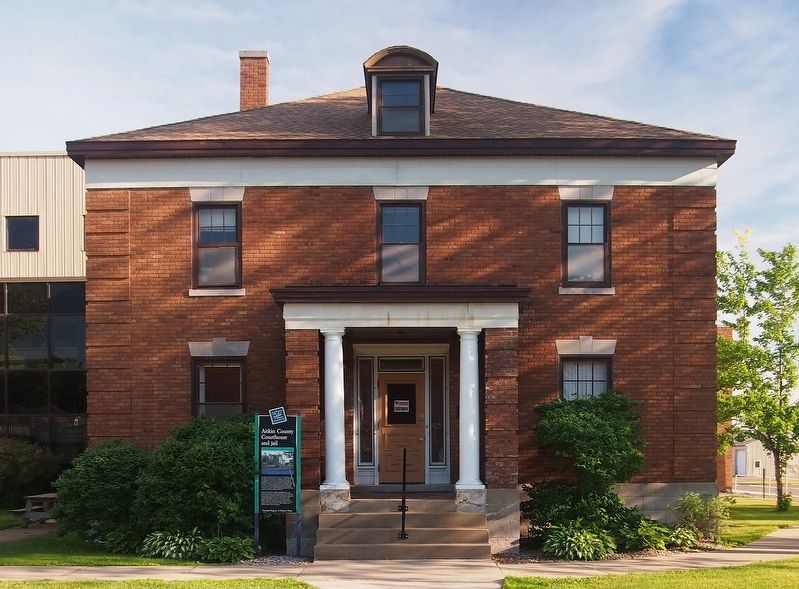
The original courthouse built on this site in 1887 included a jail and sheriff's residence. It served a population of about 2,000 people. As a logging town, Aitkin became a railhead and an important stopping point for boats on the Mississippi . . . — — Map (db m127867) HM
This is the site of the Civilian Conservation Corps (CCC) Biological Survey Camp 3. Serving as the home of Company 2705 from 1939 to 1941, as many as 23 buildings were once located here to house and support 200 men.
[Captions:] Crew . . . — — Map (db m210895) HM
The Civilian Conservation Corps (CCC), what began as a Depression era work program, became an important building block to the U.S. Fish and Wildlife Service's National Wildlife Refuge System. In 1939, seven thousand Corps participants worked at 35 . . . — — Map (db m210281) HM
Settlement
In the late 1800s, the first white settlers came to the area that is now the refuge. They were loggers, ranchers and market hunters. Loggers cut the pine trees from the land and floated them down the Rice River to the Mississippi . . . — — Map (db m210313) HM
In late 1850, some 400 Ojibwe Indians perished because of the government’s attempt to relocate them from their homes in Wisconsin and Upper Michigan to Minnesota west of the Mississippi River. The tragedy unfolded at Sandy Lake where thousands of . . . — — Map (db m206878) HM
Early water transportation on the Upper Mississippi River from St. Paul to St. Louis was hindered by fluctuating water levels. In 1878, the Corp of Engineers studied the impact of a reservoir system on the river. The study resulted in the building . . . — — Map (db m207887) HM
Of the American Fur Company was established near here about 1830, after an earlier location further south at the Northwest Company’s station had been abandoned.
William A. Aitkin for many years was a leading trader in this region. Indian . . . — — Map (db m207745) HM
This map shows the locations of some of the villages of the 19 Ojibwe Bands whose treaty annuities were paid at Sandy Lake in 1850. Today, these 19 Bands are succeeded by the 12 federally-recognized Bands whose present-day reservations also are . . . — — Map (db m207530) HM
To the native Anishinabe (Ojibwe) and to the white fur traders who bartered with them in the late 1700s and early 1800s, no Minnesota lake had a more strategic location than Big Sandy Lake, which stands at the intersection of two major trade . . . — — Map (db m210859) HM
(side 1)
Glacial Lake Aitkin
Two million years ago the first of four glaciers covered the surface of Minnesota. They were named for the limit of their southward expansion. The first was the Nebraskan, followed by the Kansan and the . . . — — Map (db m43932) HM
Dedicated to Aaron Greenwald and his comrades, who near this spot shortly after 10 A.M. on April 15, 1861, were the first Union Civil War Volunteers in the Nation.
Aaron Greenwald was killed at Gettysburg July 2, 1863, in the "Famous Charge That . . . — — Map (db m156730) HM WM
This building was designed by U.S. Government architect James Knox Taylor. It is a textbook example of Georgian Revival style architecture with its massive rectangular size, brick façade, cornice, arched windows, modillions under the eaves, and . . . — — Map (db m132571) HM
The Mississippi River was an obstacle to overland travelers attempting to cross to the other side. From 1855 to 1884 a flat bottomed cable ferry was maintained between Anoka and Champlin. For a time two ferry companies operated at this . . . — — Map (db m158388) HM
The Dakota and Ojibwa people believed that the confluence of two great rivers was a sacred place.
The Point was used as an encampment and gathering place for several tribes. It was also a meeting place to form hunting parties going north . . . — — Map (db m70897) HM
Father Louis Hennepin, Belgian Recollect missionary accompanying Sieur de la Salle's expedition to the Mississippi River region, left Fort Crevecoeur, Illinois, on February 29, 1680, for an exploration of the upper Mississippi River. On April 11, he . . . — — Map (db m225175) HM
Fireman's Grove is located here in the area just above the confluence of the Rum River. It was named for the firemen who pastured their horses at The Point. Fireman's Grove became a favorite gathering place for townspeople and visitors who . . . — — Map (db m70973) HM
The Rum and the Mississippi were highways for the earliest recorded European explorers of Minnesota. Many explorers traveled past The Point and some may have camped here including Radission, Hennepin, Du Luth, Pike, Faribault and Nicollet.
. . . — — Map (db m70569) HM
The white pine forests fell to the logger's ax in the northern Rum River pineries, "Seventy mills in seventy years could not exhaust the white pine I have seen on the Rum River" predicted Daniel Stanchfield, a lumber-wise timber cruiser . . . — — Map (db m70937) HM
Struggles and hardship are expected in building a community, but Anoka may have had more than its share of disasters. Through each trial, the community rebounded and Anoka continues to be a vital, dynamic community.
Anoka County was . . . — — Map (db m70953) HM
The Rum and the Mississippi were river highways for the Dakota, the Ojibwa, European explorers, traders and settlers.
Between 1850 and 1870 the Rum and the Mississippi became "working rivers" for lumbermen. In the fall loggers traveled . . . — — Map (db m70914) HM
Robert W. Akin (1871-1920) came to Anoka in 1898 and began working as a cashier in the State Bank. His property a few blocks south of Main Street on the east bank of the Rum River was said to be one of the "most picturesque sites in the . . . — — Map (db m162173) HM
The first dam was built here in 1853 of logs and earth fill by Caleb and W.H. Woodbury. It washed away in high water in the Spring of 1854. A second dam was built in 1854 by James McCann. This dam and its pool provided 5 sluiceways for water . . . — — Map (db m70264) HM
The square of land on the east side of the Rum River just south of Main Street has been a place for Anoka citizens to gather since the town began in the mid-1800's. Known as Bridge Square, it was a place to share news, to hear speeches and . . . — — Map (db m70586) HM
Three stone houses were built during the 1920's by Thaddeus P. Giddings (1969-1954). Giddings was the Supervisor of Music for the Minneapolis Schools and founder of the National Music Camp in Interlachen, Michigan. The stone houses were part . . . — — Map (db m70825) HM
This house was the home of three generations of the Ticknor Family, who greatly contributed to the development of Anoka. The architecture of the house incorporates design features of Gothic Revival (1867, design of original house) and the Queen Anne . . . — — Map (db m181514) HM
Built in 1872 by W.D. Washburn & Co., the mill had an annual production of 16 million board feet of lumber. Combined with the planing mills, dry kilns, etc., the mill employed about 125 men. For 17 years logs from the headwaters of the Rum . . . — — Map (db m242327) HM
Native peoples and traders met at a trading post constructed across the Rum River from The Point in 1844 by Joseph Bellanger. The Ojibwa brought furs and skins to trade for copper cooking pots, cloth, blankets, decorative beads and iron . . . — — Map (db m70921) HM
The Mississippi River forms a unique and complex ecosystem spanning 2000 miles. From its origin at Lake Itasca in Northern Minnesota to its outlet in the Gulf of Mexico the river encompasses a diversity of life found only in a very few places . . . — — Map (db m70908) HM
Who Lived Here
Thousands of years ago, glaciers and inland seas covered much of North America. These early forces shaped the land to form lakes, rives, soil deposits, and land features. Sandy soil at the southern end of the Rum River . . . — — Map (db m236855) HM
Why Settle Here? Looking for Work
Timber was a resource that drew many west and in 1847, surveyor Daniel Stanchfield noted, "Seventy mills in seventy years couldn't exhaust the white pine I have seen on the Rum River". The rivers . . . — — Map (db m70982) HM
This amphitheater is a rare example of a semi-circular, open-air theater in Minnesota. It echoes the design of ancient Greek and Roman theaters. Set into the hillside, it was designed to accommodate 1,600 people. The idea for its construction came . . . — — Map (db m230699) HM
The Mighty Mississippi River One of the world’s great rivers, the Mississippi trickles from Minnesota’s Lake Itasca, gathering the waters of the nation’s heartland as it flows to the Gulf of Mexico. On its timeless journey, the river weaves . . . — — Map (db m70952) HM
This church, the Swedish Evangelical Lutheran Church of Ham Lake as it is called on the National Register of Historic Places, has a rich history. Founded in 1872, the building was constructed on land donated by Johan and Fredrika Magnuson shortly . . . — — Map (db m207320) HM
Twenty thousand years ago, a great sheet of ice, the Superior lobe, covered this
area. At its farthest advance, it formed the St. Croix moraine, a series of high hills to the
west, south, and east. When it melted, it left behind vast . . . — — Map (db m70297) HM
Itasca grew up around an Indian trading post which was established 800 feet east of here in 1849 by Thomas A. Holmes and James Beatty. At the suggestion of Territorial Governor Alexander Ramsey, the settlement was named in honor of Lake Itasca, the . . . — — Map (db m69908) HM
The Rum River, a 148 mile river of gradual grade, is rich in history. The French explored it. The Chippewa and Sioux fought along it, and the pine logs that helped build the cities of the Midwest were floated down it during the lumber boom of the . . . — — Map (db m94721) HM
This plot marks the site of the home of John Cook, pioneer settler, who with his wife Diantha J., and children Freddie W., Mary E., and John W., were murdered by Indians April 26, 1872. — — Map (db m227703) HM
Hamden Slough National Wildlife Refuge is named after the 800-acre Hamden Lake, drained in the early 1900's for agricultural development. Much of the rich prairie soil was also plowed for agriculture. A decline in wildlife populations followed. In . . . — — Map (db m170558)
This courthouse constructed by Becker County in cooperation with the Works Progress Administration of the Federal Works Agency S. L. Stolte • State Administrator Harry Phinney • District Manager W. R. Koester • District Engineer Albert . . . — — Map (db m209093) HM
This lake and the city located on its northern shore received its name from the French word “détroit,” meaning a narrow place in a lake and in this case referred to the bar which divides Little and Big Detroit Lakes. Today this can be seen about . . . — — Map (db m233589) HM
Through woodland and prairie, along riverbanks and through sloughs, the mixed-blood American and Canadian buffalo hunters called Metis blazed trails with their oxen and squeaky-wheeled wooden carts. They carried buffalo robes and pemmican from . . . — — Map (db m206932) HM
Bad Medicine Lake also called the Lake of the Valley, was originally known to the Ojibway Indians as Ga-wimbadjiwegamag (Lake lying in a mountain depression). Among the many stories about the name’s origin are legends of serpentine fish and . . . — — Map (db m207258) HM
This trail was used by early settlers and Indians to reach the maple sugar and wild rice campsite located at the north end of Tamarac Lake. It extended east to the Ottertail River and then branched to the south and north. The south branch followed . . . — — Map (db m226131) HM
Minnesota is one of the few states where the Red River Ox Cart was used extensively as a mode of transportation. From 1832 to 1862 the carts went back and forth between St Paul and the fur trading outposts at Pembina, ND and Fort Gary in Canada. . . . — — Map (db m232425) HM
This marker locates a part of the original trail which was cut out of the forest by the U.S. Army in 1868 to facilitate travel from Leech Lake to White Earth. Soldiers accompanied the paymasters along this road in the early days to provide . . . — — Map (db m8537) HM
The first Minnesota mission to be named for Saint Columba was built by James Lloyd Breck in 1852 at Gull Lake near the present-day Brainerd. It was the fourth Episcopal church established in Minnesota.
The initial group of Chippewa Indians . . . — — Map (db m207531) HM
Beltrami County was established by an act of the state legislature on February 28, 1866.
The first post office in the county was established in Red Lake in 1875.
The first homesteader in the county was Joachim Cyr at Little Turtle Lake in . . . — — Map (db m131652) HM
June 1911 Bemidji Commercial Club entertains Louis Hill, Governor Eberhart, and others at Markham Hotel for dinner and tours them around the Bemidji area hoping Hill will commission a new Great Northern Depot in Bemidji. April 24, 1912 . . . — — Map (db m235292) HM
In commemoration of the first Reserve Unit in the United States to be called into active service in World War I. Forty eight men, composing the Fifth Division of the Minnesota Naval Militia, were mustered in for service directly to the southwest of . . . — — Map (db m235294) HM
Beltrami Camp was built in 1942 by the Works Progress Administration. It was a popular gathering place for family reunions and civic groups. The only remaining building from the Beltrami Camp is the Dining Hall. Today it is still used by the Girl . . . — — Map (db m136149) HM
The statues of Paul Bunyan and Babe were both built in 1937 in connection with a January Winter Carnival. The 18-foot Paul weighs two-and-one-half tons and stands above five tons of concrete footings. Babe was originally built to be mobile, covered . . . — — Map (db m131670) HM
Near this spot, archaeologists found evidence for a Native American fishing camp. Pottery from the camp indicates that people lived here at various times between 3,000 and 600 years ago during what is known as the Woodland Period.
Harvested . . . — — Map (db m135890) HM
Pieces of pottery and other artifacts tell archaeologists that Native Americans have lived along the shores of the Turtle River and Three Island Lake for thousands of years. Because the ways in which Native Americans decorated and made their pottery . . . — — Map (db m135881) HM
Norway Pine planted in memory of Harry Davidson 1894 — 1983
Harry and Vera Davidson operated Sunset Lodge on this site from 1938–1970. It included a café & bar, 9 cabins, and boat rentals. — — Map (db m199596) HM
In 1891, government surveyors platted this area as "meadows." Travel was difficult until drainage ditch spoil piles provided a rough bed for the first road, present-day Highway 72. A road linking Baudette and Kelliher was completed in 1914. . . . — — Map (db m191359) HM
The Big Bog was the last refuge for the lower 48 states' woodland caribou, which vanished in the 1940s. Although caribou survived in Minnesota for a century after they disappeared in Wisconsin and Michigan, multiple threats took their toll here. . . . — — Map (db m190013) HM
An early 20th century attempt to drain the bog failed, but the old ditches still mark the invincible, yet fragile landscape.
Taking on the Bog
In 1889, the federal government appropriated almost three million acres of the Red Lake Indian . . . — — Map (db m191353) HM
Constructed by dragline in the 1960s, this ditch was used by fishermen as a marina and safe harbor. Shallow water, strong winds and big waves made mooring fishing boats difficult. Docking boats by the campground along the Tamarac River could also . . . — — Map (db m191558) HM
Waskish was named by the Chippewa Indians who hunted, fished, and gathered wild rice along the Tamarack River. The Ojibway word for deer is Wawaskishi, which was shortened to Waskish by the early pioneers. The old town site was located at the . . . — — Map (db m181008) HM
The Big Bog is part of the Patterned Peatland of Minnesota, whose rare landforms and plant and animal communities provide a vital resource for for scientific research, education, and recreation. A place of wonder and renewal for many, the Big Bog . . . — — Map (db m191556) HM
You are standing at the site of an old forestry station, established decades ago to fight one of the biggest foes of forests—fire!
While pickaxes and pulaskis were common fire-fighting tools, a forester's biggest weapon may have been a tower. . . . — — Map (db m207228) HM
Minnesota Territory 1849-1858On March 3, 1849, during his last hours in office. President James K. Polk signed a bill adding a new name to the American political landscape — Minnesota Territory. A vast land, it stretched from the St. . . . — — Map (db m205213) HM
Placed on the National Register of Historic Places on Oct. 14, 2010. Built in 1896 at a cost of $3,300 on land given by Sevrin & Lisbet Huselid. — — Map (db m130999) HM
About 1866 a trading post on the Fort Wadsworth Trail was established on
Tokua Lakes a mile west of town. Early in 1878 Archbishop Ireland, after erecting a church on the present town site, located several hundred families in the vicinity through . . . — — Map (db m156662) HM
The village of Odessa began in 1879 with it's first settler, A.D. Beardsley. He was the Milwaukee depot agent and owner of the first general store. Mr. Beardsley lost a three-year-old daughter, Dessa, to diphtheria. It was after this girl that the . . . — — Map (db m100967) HM
Imagine a tremendous torrent of glacial melt water pushing and then bursting across the continental divide and scouring its way to the Gulf of Mexico. The massive river was, in places, almost two miles wide and 130 feet deep. About 13,000 years ago, . . . — — Map (db m160960) HM
Of all the geological agents which have played a part in shaping the face of Minnesota, the most overwhelming and powerful one is glacial ice. At least four times during the last million years, continental glaciers have spread over the state . . . — — Map (db m101379) HM
Legend has it that Paul Bunyan was mighty in the sport of fishing as in all else. He picked Minnesota for most of his fishing and is credited with creating more than a few of its ten thousand lakes.
Big Stone Lake, visible here to the . . . — — Map (db m101378) HM
The above locations of Welsh Churches were established in Blue Earth County after the first Welsh settlers expanded from this farm site, which was claimed by Humphrey Jones and Thomas Y. Davis on April 26, 1855.
In the wooded area . . . — — Map (db m203325) HM
"Who says we cannot build railroads in the winter?" asked the Mankato Weekly Union on December 10, 1869, in an article announcing that the tracks of the St. Paul & Sioux City Railroad had reached the new town of Lake Crystal.
The . . . — — Map (db m67364) HM
Philosophy.
Amos Owen was a Dakota elder and spiritual leader who wanted to preserve and restore traditional Dakota beliefs and practices. He believed that the suppression of Indian peoples had led to many parts of the culture being almost . . . — — Map (db m21588) HM
Frances "Bick" Kenney, daughter of Patrick and Rose Kenney, was born on July 13, 1891, in Minneapolis, Minnesota. The Kenney family lived in this house from 1898 to 1911. Frances Kinny Kirch and Maud Hart Lovelace were lifelong friends. Maud . . . — — Map (db m237496) HM
Maud Palmer Hart, daughter of Thomas and Stella Hart, was born on April 25, 1892, in Mankato, Minnesota. The Hart family lived in this house from 1892 to 1906. It was here that Maud met her best friend, Frances "Bick" Kenny, who moved into the . . . — — Map (db m237515) HM
In Honor of
Union Veterans of
the Civil War
Erected by the City of Mankato
for Alexander Wilkin Post No. 19
Department of Minnesota
Grand Army of the Republic — — Map (db m67086) WM
The last act of the Minnesota Dakota (Sioux) War took place here in Mankato on December 26, 1862 when thirty-eight Dakota Indians died in a mass execution on this site.
The Dakota War was a culmination of years of friction between Dakota and . . . — — Map (db m14195) HM
Early European explorers were drawn to the Minnesota River Valley's unique characteristics just like the Native Americans before them. French Fur Trader and Explorer Pierre Charles Le Sueur was the first recorded European explorer of the . . . — — Map (db m237541) HM
European settlers began arriving in the area in the 1850s. The Treaty of Traverse des Sioux, signed July 23, 1851, allowed settlers to claim land that had once belonged to the Dakota. In 1852, Parsons King Johnson and Henry Jackson claimed the . . . — — Map (db m236258) HM
This building was used to store the customer's grain as it was brought in and the finished product of flour or grist until it could be picked up. It may have also doubled as sleeping quarters for those who preferred to wait until their grain could . . . — — Map (db m197027) HM
This area (Bunker Hill) once served as a Civil War recruitment center, but this was not the primary reason for its acquisition. The Mankato City Council purchased approximately 10.2 acres at 150 dollars an acre on October 15, 1874, with the . . . — — Map (db m68276) HM
Through treaty negotiations, the Ho-Chunk or Winnebago moved their homes to Blue Earth County in 1855, and by 1863 they were gone. Parts of what would become Minnesota, Wisconsin and Illinois had been their homeland for centuries. European explorers . . . — — Map (db m14053) HM
Rensselaer Dean Hubbard, successful entrepreneur and civic leader, built his house on Broad Street in three stages: in 1871, 1888 and 1905. During the
late 19th century, many of Mankato’s captains of industry and commerce established their . . . — — Map (db m66338) HM
This house, at 332 Center Street, was the Kenney family home from 1898 until 1911. Patrick Kenney worked for the Singer Sewing Machine Company in Minneapolis and came to work at their Mankato store in 1897. The Kenneys purchased this house in 1898 . . . — — Map (db m202939) HM
The desire to honor the memory of Mankato's Civil War dead prompted a citizens' committee headed by John Ray to purchase the triangular parcel of land in the Warren's Addition, bordered by Broad, Lincoln and Grove streets, and dominated by a . . . — — Map (db m66655) HM
Born in Mankato on April 25, 1892, Maud Palmer Hart lived in this home at 333 Center Street until 1906. In 1897 Frances "Bick" Kenney moved into the house across the street, at 332 Center Street, and the two girls became lifelong best friends. . . . — — Map (db m203292) HM
Following the usual pattern of river town development, steamboating was essential for Mankato, from its founding in 1852 until the arrival of the first railroad in 1868.
During the heyday of steamboating at Mankato, boats based at St. Paul . . . — — Map (db m129536) HM
Since the end of the last ice age, Minneopa Creek has carved a ravine through sandstone bedrock, creating a spectacular double waterfall.
Sometimes roaring, sometimes just a trickle, these falls have been an attraction for hundreds of years. This . . . — — Map (db m231657) HM
Native Americans arrived in the area nearly 11,000 years ago, shortly after the glaciers receded. They lived in small, migratory, family-based groups and used plants and animals from the river valley and nearby uplands. Around 2,500 years ago, . . . — — Map (db m237583) HM
Before the railroads and highways, the river was the best way to get goods and people to the new frontier of southern Minnesota. River transportation was much faster and easier than traveling through the dense forests that covered much of central . . . — — Map (db m236265) HM
Built in 1857 in Mankato Township and was moved to this site, which was once the site of the fur trading post of Henry H. Sibley by the Blue Earth County Historical Society in 1931. — — Map (db m66845) HM
This Park is named in honor of Ray Erlandson, and through him, all the men and women who have served the citizens of the City of Mankato as firefighters promoting and preserving the public's safety. Ray Erlandson served as a City of Mankato . . . — — Map (db m120008) HM
The Seppman wind mill produced flour until it fell victim to natural disasters and new milling technology.
Construction Begins
Realizing the need for a local source of flour, Louis Seppman, a stone mason by trade, began . . . — — Map (db m197018) HM
On October 3, 1887 the City of Mankato purchased 120 acres for $13,088 at the confluence of the Blue Earth and Minnesota Rivers to create Mankato’s first park. Sibley Park was named for Henry Hastings Sibley (later Minnesota’s first Governor) who . . . — — Map (db m66483) HM
2029 entries matched your criteria. The first 100 are listed above. Next 100 ⊳