Planted circa 1875. Declared Historic Cultural Monument No. 19 by the Cultural Heritage Board, Municipal Art Department, City of Los Angeles. — — Map (db m188853) HM
From Sin to Science, A Park For The People
For decades into the 20th century, Los Angeles not only fed the world’s imagination with films and television — it fed the world’s bellies, too.
Los Angeles County prided itself on . . . — — Map (db m216967) HM
This historic palm tree stood for more than 25 years at the entrance of the Southern Pacific Station. At this railroad portal of the city it became a familiar landmark to many thousands of Los Angeles and Southern California citizens and visitors . . . — — Map (db m155323) HM
This area was originally planted with annual and perennial flowers. Roses were tested, conditions proved to be satisfactory, so in 1927 the Rose Garden was established. It contains approximately 15,000 bushes of 145 varieties. The Los Angeles . . . — — Map (db m215943) HM
This library garden courtyard and fountain are dedicated to the memory of Carolyn Craig Franklin (1919–1993).
They were donated by Dr. Carl Franklin, Vice President Emeritus and Professor of Law at USC, and their four children: Craig, . . . — — Map (db m130210) HM
Early Life
As a young man, Theodore Payne (1872-1963) immigrated to Southern California from England to pursue a career in horticulture. He fell in love with the local flora, especially our wild flowers, which were threatened by . . . — — Map (db m118536) HM
The Verdugo Hills and Tujunga Wash
hold a surprising wealth of biodiversity.
When you look out at these areas, what do you see?
You might be looking at plants that grow in
the San Gabriel Mountains but not in the Santa Monica
Mountains — and . . . — — Map (db m198564) HM
This park and memorial stand as a tribute to the young men who lost their lives on the Loop Fire, to those who survived, and to firefighters everywhere.
Forever Honored - Those Who Lost Their Lives
Raymond Chee - Age 23
• James . . . — — Map (db m79155) HM
Declared Historic Cultural Monument No. 31 by the Cultural Heritage Board, Municipal Art Department, City of Los Angeles.
panel 2:
Why are there swastikas on
this historic home?
The symbol on the Orcutt Ranch house is . . . — — Map (db m170282) HM
Roses were the central feature of Roddy McDowall's English garden - a place
he enjoyed sharing with his many friends and loved ones. How fitting that
Roddy's dedication to the organization he supported passionately throughout
his life is . . . — — Map (db m235635) HM
One of Rhoda Rindge Adamson's many interests was gardening. At times several full-time gardeners used this lath house to maintain beautiful gardens.
This is the end of the self-guided tour. If you are able, please join the volunteers . . . — — Map (db m237690) HM
Welcome to the Vetter Mountain Fire Lookout Tower in the Angeles National Forest. As you can see from the spectacular vistas, Vetter Mountain is an ideal location for a fire lookout.
The Vetter Mountain Lookout was constructed in 1937 and . . . — — Map (db m201274) HM
In memory of Alfred Henry Sturtevant, Geneticist and Naturalist, Professor of Biology at the California Institute of Technology from 1928 to 1970.
These iris resulted from genetic studies he made between 1952 and 1969. — — Map (db m124155) HM
The property and landscape surrounding you
was historically the territory of the Hahamongna
Tribe of Native Americans, who lived in small
villages along the banks of the Arroyo Seco. It
later became part of the vast lands of the San
Gabriel . . . — — Map (db m151819) HM
Julius Caesar's reign over Rome was
approaching its dramatic end (44 BCE),
when this giant sequoia sprouted - the
tree providing this magnificent round.
Until felled in Tulare County by a windstorm
in 1961, this massive tree, nicknamed . . . — — Map (db m218620) HM
The Palos Verdes Peninsula supports a plant community called coastal bluff scrub that contains elements of coastal sage scrub. Coastal sage scrub communities are composed of soft, witty sub-shrubs. Coastal sage scrub seen at this site is dominated . . . — — Map (db m81923)
Arrived in the vicinity of El Monte in 1884, and became Superintendent of E. J. (“Lucky”) Baldwin ranches, where he worked for 9 years. He owned 322 acres of land which he had purchased in 1887. He set 70 acres of it in walnuts and he . . . — — Map (db m150773) HM
The San Jose Division Headquarters of the
Los Angeles County Forestry Department
was constructed on this site in 1927.
The office had command of all fire
activity from Duarte to the San Bernardino
County line, and from the boundary of . . . — — Map (db m167106) HM
This location was once the site of the Robert M. Teague home and nursery office. The
small building on the right was the office. By 1910, the San Dimas Teague Nursery had
become the leading supplier of citrus trees in the world. Mr. Teague was . . . — — Map (db m167198) HM
R.M. Teague came to San Dimas in 1878 and developed the largest citrus nursery in the world.
By 1888, he had close to 700,000 seedling trees growing in areas throughout San Dimas. He
shipped trees to all parts of the world including Spain, . . . — — Map (db m167195) HM
Grapevine Park
Beyond
these walls
stands the old
Grapevine,
planted in 1861.
This famed Vine
stands today as
a Heritage and
a monument to
the early pioneers
of San Gabriel.
"The Old Mother Grapevine",
planted . . . — — Map (db m197094) HM
'California' is believed to be the oldest camellia plant on record in Southern California. It arrived in 1888 as an unnamed seedling and was purchased for 25 cents off a Japanese tramp steamer in Redondo Beach harbor. For nearly 70 years the plant, . . . — — Map (db m124471) HM
The arch was originally constructed in 1926 to attract
visitors to John Evans Olmstead's Live Oak Manor Cacti
Gardens, a point of interest frequented by tourists and
sightseers along the "old" San Fernando Road, today's
Sierra Highway. The . . . — — Map (db m156748) HM
To honor George T. Hastings, author of “Trees of Santa Monica,” October 10, 1963—his 88th birthday—in appreciation of his dedication in sharing his knowledge and love of trees, flowers and birds.
To honor Grace L. . . . — — Map (db m130429) HM
This world famous Wistaria Vine, one of the 7 Horticultural Wonders of the World, was planted in 1894 from a one-gallon pot. Listed as the World’s Largest Blossoming Plant by the Guinness Book of World Records, it covers nearly one acre, weighs over . . . — — Map (db m120815) HM
Paradox Hybrid Walnut Tree
Planted in 1907 as an experiment for the
University of California.
California Registered Historical
Landmark No. 681.
Dedicated 1963
By Whittier area community beautiful
Grand Parlor Native . . . — — Map (db m241036) HM
This slab of a Giant Sequoia was cut from a 2,000 yr old Sequoia toppled by a winter storm in 1979 in Eastern Tulare County. 200 feet in length and 50 feet in circumference, the tree weighed 900,000 lbs. In 1981, LDG Logging Co of Oakhurst purchased . . . — — Map (db m60308) HM
Taking two years to construct and opening in August 1876, The flume ran 52 miles from Sugar Pine sawmill to the planing mill and railroad in Madera. This wooden flume transported lumber and loggers to Madera across deep canyons, streams and . . . — — Map (db m84537) HM
Warm days, gold and crimson foliage, and migratory animals mark the season.
Sonoma chipmunks busily prepare for hibernation. They forage through the woods in search of seeds, nuts, and berries. When their cheek pouches are full, they dig a small . . . — — Map (db m92646)
You are entering one of the world's last remaining ancient coast redwood forests. This magnificent forest...with its redwoods, the tallest of living things...is protected and made accessible to the public by the National Park Service for the . . . — — Map (db m82387) HM
The Coast Redwood belongs to the plant family Taxodiaceae, which also included fourteen other species. Members of the Taxodiaceae family are conifers that generally have soft wood, long, straight trunks, round cones, and narrow, needle-like . . . — — Map (db m104063) HM
This two-story, clapboard structure, known as the Burdell Frame House, was built in 1874 for Mary Burdell’s cousin, Mary Joynsen.
Originally a rectangle building, it has been modified with a projecting, two story addition on the end facing . . . — — Map (db m13246) HM
Employees Created a Quiet Place of Their Own
In contrast to the formal landscaping at the front of the Administration Building, the staff gardener created an informal, tree-lined garden walk for the employees and their families to enjoy. The . . . — — Map (db m203565) HM
Creating an Experience to Match the Dignity of the Trees People have revered this Grove and its mighty trees for thousands of years. Through ecological restoration, the health and resilience of these giants will be protected and all visitors . . . — — Map (db m160409) HM
Trees Worthy of a Nation's Protection, June 30,1864 In the midst of the Civil War President Abraham Lincoln signed the Yosemite Grant Act. This established Yosemite Valley and the Mariposa Grove as the first federally protected wild places in . . . — — Map (db m160408) HM
Standing relatively short at 209 ft. (63.7 m), the Grizzly Giant measures 96 ft. (29 m) in circumference and 28 ft. (8.5 m) in diameter at the base. What do you notice first about this big tree? Is it the blackened fire scars at the base of the . . . — — Map (db m159099) HM
”You can save a place, but it’s never really safe. It always takes people caring. It always takes vigilance. It always takes effort to keep those forces at bay that want to crowd in, want to change it, want to over-commercialize it. Once it’s . . . — — Map (db m160410) HM
Walk through this living tree and look for evidence of it healing itself. Bark of this sequoia is growing inward in an attempt to close over its wound — the large tunnel carved in 1895. Thought to have served as a lower elevation winter . . . — — Map (db m84231) HM
This nine-foot section of a giant sequoia was cut 30 feet from the base of a tree that fell in the Mariposa Grove in 1919. Annual rings show the tree's to be 996 years old, but at the base of the tree, where the diameter was 14 feet, the age was . . . — — Map (db m192082) HM
This state forest is named in honor of Jacob Green
Jackson (1817-1901), founder of the Caspar Lumber
Company. His motto "Walk Humbly - Deal Justly," was
exemplified by his operation and that of his
successor and grandson, Casimir Jackson . . . — — Map (db m153770) HM
This monument was erected in honor of all the people who were part of what once was a thriving community when the Crane Creek and Willow Ranch Lumber Companies were in operation here from 1929 to 1959. The land was given to Modoc County by the . . . — — Map (db m10367) HM
In Loving and Grateful Memory of
The C-130 Crew
Steve Wass, Craig Labare and Mike Davis
Who gave their lives to save
our community on June 17, 2002 — — Map (db m23036) HM
Limekiln
In the 1870s and 1880s, locally quarried limestone was kilned (smelted) in four huge wood-fired kilns. The powdered lime was then packed in barrels and cabled from the canyon down to the beach and out to ocean-going schooners . . . — — Map (db m196815) HM
Even though Monterey cypress trees prefer this area's rugged bare granite headlands, the Lone Cypress is a testament to the hardiness of these trees. It has withstood Pacific storms and winds for roughly 250 years. Fences and cables now offer added . . . — — Map (db m8476) HM
This bell was salvaged from the ruins of the 1906 Earthquake in San Francisco and hung at the McMenamin’s Mission Inn.
Robert C. Littlefield acquired it in 1961 and placed it in his garden home.
His widow Patricia donated it to the . . . — — Map (db m63222) HM
Coast Redwood
Sequoia sempervirens
This "Moon Tree" is a Coast Redwood grown from a seed that in January 1971 was carried to the moon and brought back to earth by Major Stuart Roosa, Command Module Pilot for Apollo 14.
The . . . — — Map (db m63500) HM
In 1542, the explorer Cabrillo called this point of land Cabo de Nieve - Cape Snow- to describe the white landscapes before him. No one's sure what he saw. In 1774, Tomás de la Peña, a missionary, gave this western-most point on the Monterey . . . — — Map (db m83330) HM
In the 1860’s there were four saw mills in this area. This display, in honor of his founding fathers, is from the Tom Rowe Saw Mill, and displays how the mill works. The foreman stood in the cage and called out the beam size (8x8, 12x12, etc.) then . . . — — Map (db m39895) HM
Near this spot stood the tree which marked what was believed to be the campsite of the family of George Donner in the winter of 1846. The tree stood for 150 years (missing) the Donner families camped in Alder Creek before it succumbed to Mother . . . — — Map (db m129928) HM
One of Truckee’s earliest settlers. Schaffer in 1866 built the first lumber mill in the town. He freighted the locomotive San Mateo to Truckee in a winter crossing of the Sierra prior to the laying of Central Pacific tracks. This building “The . . . — — Map (db m60580) HM
The Native People
The cultural history of people inhabiting the western slope of the Sierras spans a period of at least 3,500 years. It is known that the Nisenan, a Native California tribe, occupied the geographic region between the Sierra . . . — — Map (db m44642) HM
The Cactus Garden was conceived by Rudolph "Rudy" Boysen, Superintendent
of Anaheim City Parks from 1928 to 1949. Mr. Boysen, a noted botanist and
creator of the "boysenberry," placed a variety of cactus in this garden, including
several rare . . . — — Map (db m193789) HM
This grove of dawn redwood trees was planted by the Orange County Cemetery District as a memorial to the People of Chinese Heritage interred in the Anaheim Cemetery. This species of tree was thought to be extinct until they were rediscovered growing . . . — — Map (db m197717)
This section weighs five tons and measures 7½ feet in diameter. The original tree, estimated to have been 200 feet tall, was part of a sub-tropical forest 55 to 70 million years ago in what is now Colorado. Scientists believe it to be of the Redwood . . . — — Map (db m155279) HM
How the Dolbeer Donkey steam engine got its name is one of the real mysteries of the West. Some folks say it was called a "donkey" because loggers thought it was too puny to merit a horsepower rating. Invented by John Dolbeer, this portable steam . . . — — Map (db m155280) HM
This nine foot band saw is among the largest log saws ever used in the sawmill industry. It weighs over 38,000 pounds and has a blade that stre[t]ches over fifty-six feet in length. This saw was used to cut Douglass Fir logs up to ten feet in . . . — — Map (db m199505) HM
This nine-foot band saw is among the largest log saws ever used in the sawmill industry. It weighs over 38,000 pounds and has a blade that stretches over 56 feet in length. This saw was used to cut Douglas Fir and Ponderosa Pine logs up to ten feet . . . — — Map (db m66262) HM
These Australian nut-producing trees are the oldest Macadamia tetraphylla in California. They were planted prior to 1890 by a local spiritualist health colony, the Societas Fraternia. Members experimented with many varieties of fruits and nuts to . . . — — Map (db m50018) HM
Water from the Santa Ana River was largely responsible for the transformation of this arid valley into productive agricultural land. Irrigation companies in Orange County were in operation as early as the 1860s. The two largest were the Santa Ana . . . — — Map (db m59529) HM
For over 125 years a grand pine tree known as the “Big Tree” stood in the centerline of Highway 28 in the heart of Tahoe City.
In 1940 the Federated Women’s Club literally joined hands around the tree when the California Division of Highways’ . . . — — Map (db m34524) HM
They were fallers, buckers, swampers, barkers, skidders, snipers, doggers, greasers, bull punchers, skinners, hook tenders, choker setters, rigging slingers, high climbers, donkey men, whistle punks, river pigs, and more. Once they were lumberjacks, . . . — — Map (db m56737) HM
Donated by: Plumas Nat. Forest
Built by: Company 989 C.C.C, 1935
Dismantled & Rebuilt by Reserve Navy Mobile Construction Battalion – 2 “Sea Bees” — — Map (db m56501) HM
Established in 1911 by S.B. Hampton, this was the center of 2,000 acres of groves, the largest single lemon ranch in California. The remaining headquarters and surrounding buildings were converted to Corona Heritage Park & Museum Dec. 7, 2000 by a . . . — — Map (db m105188) HM
A common question asked by visitors entering Joshua Tree National Park through the southern entrance is “Where are the Joshua trees?” Sometime the Mojave yucca, a close relative is mistaken, for a Joshua tree. The reality is that Joshua . . . — — Map (db m92514) HM
Logging was one of the most significant
impacts on the natural landscape on the
western side of the San Jacinto Mountains.
Beginning in 1875 and lasting through the early 1900s,
a number of logging camps and mills were established
in the . . . — — Map (db m232790) HM
To Commemorate the introduction of the first Marsh Grapefruit Trees into California, brought to Riverside from Lakeland, Florida in 1890 by Twogood and Cutter, pioneer nurserymen, and to honor J.E. Cutter who planted here one of those first trees. — — Map (db m82144) HM
Developed at U.C.R. and patented in 1980, is one of a series of citrus varieties to emerge from research in the University of California system. It is planted on this 14th day of February, 1982, as a tribute to the Citrus Experiment Station in . . . — — Map (db m199539) HM
This is the place of the Great Oak or Wi’ia$ha (We-awsh-ah). The great oak is a member of the wi’ia$al or Coast Live Oak Family (Quercus Agrifolia). Estimates range anywhere from 500 to 2000 years old. The Great Oak continues to attract people to . . . — — Map (db m36210) HM
HISTORY
When Spanish governors ruled the California territory, its capitol was moved from town to town between San Diego and Monterey.
San Jose had already been designated the capitol by the time California was granted statehood in 1850. . . . — — Map (db m15017) HM
A STUMP IS ALL THAT REMAINS of a Silver Maple transplanted from the Battlefield of Chattanooga. In 1897 the sapling was planted here as part of a Memorial Grove dedicated to Union soldiers who fought in the Civil War. The first war memorial to . . . — — Map (db m14984) HM
Dedicated on April 14, 1983 by Governor George Deukmejian celebration of the 50th anniversary of the Civilian Conservation Corps — — Map (db m90265) HM
McKinley Rose Garden Park History McKinley Park, as we know it today, was opened in 1871 as the privately owned East Park, a name given to it for its location in the undeveloped area, just east of city limits. As a ploy to increase street-car . . . — — Map (db m137486) HM
In the spring of 1852, over one hundred Mormon men donated a full thousand man-days of arduous labor, to construct a road up Waterman Canyon, past this spot, and into the prime timber, where some of their enterprising bethren established six . . . — — Map (db m154361) HM
"I never thought I would outlive the trees"
A century old herself in 2005, and seeing many of her beloved trees bow to beetle and flame, Pauliena Lafuze had done just that. She has been a Lake Arrowhead Woman's Club member since the . . . — — Map (db m30409) HM
Ontario's history has been shaped by pioneers who built a new community by combining their own knowledge and skills with the energy and determination generated by the promise of
this extraordinary landscape. George Chaffey, Ontario's founder, . . . — — Map (db m149487) HM
This is one of nine young pepper trees purchased and planted on Euclid Avenue by the students of Ontario's nine public elementary schools in observance of Arbor Day, March 8, 1954.
The young trees were planted as replacements for mature trees . . . — — Map (db m124287) HM
The two-wheel logger placed
at this location was used in the
last part of the 19th century by
Brookings Lumber Company to
harvest timber from this location.
Pulled by oxen, the wheels which
stand seven feet tall straddled
the large pine logs, . . . — — Map (db m197747) HM
Her tireless efforts to establish Joshua Tree National Monument contributed to a heightened appreciation, not only of the Joshua Tree, but of the total desert environment. — — Map (db m116863) HM
Here stands the world's first electrically-lighted outdoor Christmas tree, unveiled at the Hotel del Coronado on December 24, 1904 — — Map (db m70553) HM
In May, 1936, the Rotary Club
planted this starpine for the
citizens of Coronado. This tree
given by Emily T. Thompson in
memory of her husband Charles. — — Map (db m117524) HM
Native to the Canary Islands this unusual tree was planted at The Del prior to the turn of the century where it thrives in our temperate southern California coastal climate.
The Dragon Tree was used as a backdrop in the Marilyn Monroe movie . . . — — Map (db m70552) HM
San Diego’s Cultural Oasis
Located just minutes away from downtown San Diego, Balboa Park provides an enriching experience for more than 14 million visitors from near and far each year. Referred to as “the Smithsonian of the . . . — — Map (db m73907) HM
This plaque commemorates the life and influence of a woman who envisioned San Diego beautiful. On this site she operated a nursery and gained world renown as a horticulturist. She was the first woman to receive the International Meyer Medal in . . . — — Map (db m51098) HM
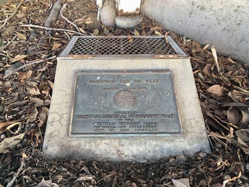
Moreton Bay Fig
(Ficus Macrophylla native to Australia)
In 1904 the House of Representative legislated protection of this tree. Requested by President Theodore Roosevelt after a visit of the area.
This tree is now over 200 years old. — — Map (db m70319) HM
The Pioneer Truck Company was the first occupant of this building owned by Roscoe Hazard and Elwyn Gould. It was used as a furniture and van storage warehouse. In order to avoid extra handling the San Diego & Arizona Santa Fe Railroad spur tracks . . . — — Map (db m191981) HM
The Botanical Building is widely acclaimed as the most photo- graphed spot in San Diego. Alfred D. Robinson, a founder and President of the San Diego Floral Society, suggested the construction of a lath house for the 1915 Panama California . . . — — Map (db m209497) HM
1915 - 1955
In Balboa Park the year 1915, San Diego opened its Panama-California Exposition. Designed to call attention to San Diego and bolster the economy, the Exposition highlighted archaeological and anthropological displays as well as . . . — — Map (db m209206) HM
Designed by architect Richard Requa (1883-1941), this sunken garden and stone amphitheater were built by government-funded work relief employees during the Great Depression of the 1930s. The area is used for events and plays and has been cultivated . . . — — Map (db m209486) HM
This huge timber was once a bowsprit aboard Forester, a four-masted schooner built in 1900 to carry lumber from the Pacific Northwest to growing coastal ports like San Diego. After many years of service, Forester was eventually . . . — — Map (db m229834) HM
From the 1920s through the 1960s, island slopes
gistened every summer with the vibrant pink
blossoms of an iceplant (Drosanthemum
floribundum) known by the residents as "Persian
carpet.” The iceplant solved two problems
it reduced . . . — — Map (db m194674) HM
In 1880, Finnish sea captain Gustave Niebaum acquired the Inglenook Estate and began building the stone chateau for his winery. His wines became world renowned and contributed to the growing fame of the Napa Valley.
Francis and Eleanor Coppola . . . — — Map (db m236038) HM
In the winter of 1894 the California Midwinter Exposition arrived in Golden Gate Park. Some of the most popular attractions at the fair were exhibits of people from around the world; Native Americans, Egyptians, Aleutians, Hawaiians, Turks, South . . . — — Map (db m132112) HM
In the 1860's, San Francisco was a booming city fueled by the Gold Rush and the first transcontinental railroad. Civic leaders envisioned a large park and arboretum similar to those in European cities and the eastern United States. Skeptics . . . — — Map (db m106635) HM
California’s first municipal greenhouse was completed in 1879. It was patterned after the Conservatory, Kew Gardens, England. A distinguished example of late Victorian style using early techniques of mass production and assembly of simple glass . . . — — Map (db m143442) HM
3434 entries matched your criteria. Entries 201 through 300 are listed above. ⊲ Previous 100 — Next 100 ⊳