After engaging Union forces in Columbia the afternoon of July 3, Gen. John Hunt Morgan’s command continued north on the Columbia-Lebanon Pike. Just beyond the town, they passed Union Camp Gilbert, formerly named Camp Boyle, now abandoned - the . . . — — Map (db m170574) HM
A foremost champion of the Union, a staunch friend of the stricken South, defender of constitutional freedom. Born Columbia 1817, died 1895 and buried in city cemetery. Veteran Mexican War, leader famed First Kentucky Union Cavalry, hero of many . . . — — Map (db m83387) HM
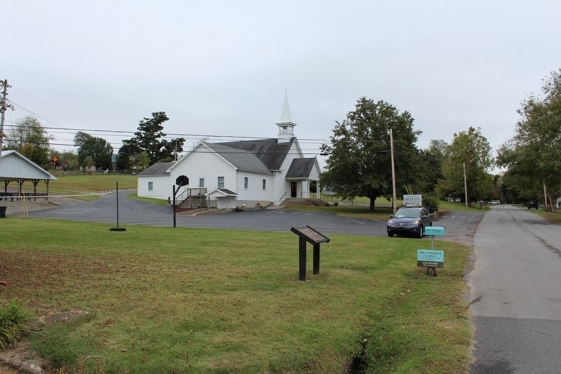
Active Presbyterian congregations formed early in the county’s settlement: 1803 on Col. Casey’s farm & 1827 in Columbia. Church was built in 1857 and has had continuous services ever since. County and city congregations merged in 1912. . . . — — Map (db m170507) HM
General John Hunt Morgan's cavalry, returning from second Kentucky raid, passed here on way back to Tennessee, Jan. 1, 1863. On raid, Union's rail supply line wrecked and $2,000,000 property destroyed. July 3, 1863, Morgan here again drove out . . . — — Map (db m83391) HM
Frank Lane Wolford (1817 - 1895). Adair County native, organized 1st Kentucky Cavalry (US) in 1861. His men knew little about the drill and discipline but had the utmost confidence in Wolford and he in them. The soldiers supplied their own horses . . . — — Map (db m170508) HM
Male and Female High School Site
The Columbia College Joint Stock Company formed in 1853 to build the M&F School. It was conveyed to trustees appointed by Transylvania Presbytery and opened in 1855. The building was a Union Camp during . . . — — Map (db m170509) HM
John Hunt Morgan entered Kentucky July 2 with about 2,500 men who swam the rain swollen Cumberland River - many naked, not to be encumbered with soggy clothes. The rebel yell of the on-coming nude men took the Union scouts by surprise.
Columbia . . . — — Map (db m170510) HM
In November 1863, Dumont Hill looked like a city of tents. Each regiment arranged its tents according to army regulations. At one end was a guard station. The officers’ latrines, called sinks, were at the other end. In between was the baggage train, . . . — — Map (db m152742) HM
A Once Proud Army in Tatters
In early 1862, the Union Army of the Ohio numbered almost 70,000 men. New and veteran soldiers alike were eager for action. By November, the army was demoralized, angry that their commander, General Don . . . — — Map (db m152736) HM
Camps of Soldiers Surrounded Scottsville
Tents housing almost 5,000 soldiers—ten times the population of Scottsville in 1862—covered the hillsides around town. Imagine what it looked like. Imagine the sounds of men drilling, . . . — — Map (db m152739) HM
Confederate forces of 200 under Col. John M. Hughs attacked here, Dec. 8, 1863. Twelve days earlier he had attacked Monticello, Ky., captured then paroled garrison of 153 men; no supplies. Continuing to harass USA forces, seek stores[,] he came . . . — — Map (db m170511) HM
Ebenezer Dumont twice served his country in time of war. He fought in the Mexican War, earning the rank of lieutenant colonel. Afterward the Vevay, Indiana native resumed his successful career in politics. When the Civil War began Dumont did not . . . — — Map (db m152741) HM
Captain Eli Lilly commanded the 18th Indiana Battery, the only battery known to have been at Scottsville. While here, the battery refitted, obtained ammunition, and procured horses to replace those that died in a fire at Allen Springs the night . . . — — Map (db m152745) HM
On August 29, 1862 at the beginning of the Confederate Invasion of Kentucky. Colonel John Hunt Morgan rode into Scottsville, leading a brigade of 1,100 cavalrymen. Morgan and his men were on their way to Lexington, where they planned to join . . . — — Map (db m131263) HM
In early October Morgan’s cavalry swept through the Trammel Community in search food and supplies. Some, such as John Howard Morgan and his mother, Isabella, who were relatives of John Hunt Morgan and were sympathetic to the southern cause, . . . — — Map (db m170512) HM
1860 – A Bustling County Seat Town
Imagine Scottsville in 1860. A fine two-story octagonal brick courthouse dominates the busy court square. The prosperous rural town of 403 residents boasts a public spring, at least one church, a . . . — — Map (db m152751) HM
Each regiment had a quartermaster, who provided everything the men needed except food and weapons.
Quartermaster Wainwright
While in Scottsville, Lieutenant William A. Wainwright, quartermaster of the 75th Indiana, obtained and . . . — — Map (db m152750) HM
Seven regiments of infantry and one artillery battery encamped at Scottsville in November 1862. These regiments made up the 12th Division of the Army of the Cumberland under the command of General Ebenezer Dumont.
Among the soldiers at . . . — — Map (db m152747) HM
Oct. 8, 1862, during Battle of Perryville, Gen. Jones Withers' troops of Gen. Kirby Smith's CSA army attacked USA force of Gen. J.W. Sill near Fox Creek while Smith skirmished with Sill's rear guard. Many Union prisoners and 20 wagons captured. A . . . — — Map (db m162489) HM
The McAfee bros., James McCoun, Jr. and Samuel Adams, first white men to explore this area, 1773. Cove Spring and Cove Spring Branch in Franklin Co. boundary line, 1794. Maj. Gen. Kirby Smith, CSA, and troops camped here on their way to join General . . . — — Map (db m105464) HM
This renowned scholar, raconteur, and lawyer was born in Anderson Co. Educated first in a one-room school at Glensboro, he graduated from U.K. Law School in 1912. Among his books was Lincoln and the Bluegrass (1955). His talk on Cassius Clay, . . . — — Map (db m34786) HM
Fort Jefferson (also known as Camp Crittenden) was the second of two Union Army posts established in Ballard County in September 1861, following the Confederate occupation of Columbus. Fort Jefferson was first established during the American . . . — — Map (db m18493) HM
One of first Kentucky positions, Fort Jefferson, occupied by Union troops after Confederate seizure of Columbus, Sept. 1861. From this base, Gen. U.S. Grant directed demonstration against Columbus, Jan. 1862. Troops from here joined in capturing Ft. . . . — — Map (db m18519) HM
CSA General John Hunt Morgan and a company of troops arrived here, May 11, 1862. They seized a train reported to be carrying some of Morgan's men captured at Lebanon, Tenn. Instead, it carried railroad employees whom he released. Morgan burned the . . . — — Map (db m321) HM
General Joseph H. Lewis, commander of the famous Orphan Brigade, established, at the outbreak of the Civil War, a recruitment and training camp here in Cave City. Here he formed the Confederate 6th Kentucky Infantry Regiment, for which he received a . . . — — Map (db m130009) HM
On May 11, 1862 Col. John Hunt Morgan and his advance guard seized the Cave City depot and captured the next train that stopped. Morgan's entire command arrived shortly thereafter. Morgan's troops proceeded to destroy the train; four passenger . . . — — Map (db m322) HM
October 6, 1863
On October 6, 1863 Confederate Col. John M. Hughes, commanding 129 men of the 25th Tennessee Infantry, attacked Fort Wiliams. The 37th Kentucky Mounted Infantry, some 420 men under the command of Maj. Samuel Martin, . . . — — Map (db m130010) HM
Taken from parts of Green and Warren counties. Glasgow, county seat, was founded in 1799. County received name from the “barrens” or prairies of this region.
Early explorers and settlers came through this area. In Civil War, first . . . — — Map (db m88132) HM
On Dec. 24, 1862, main body of Morgan's Raiders made camp south of here. Capt. Quirk and scouts entered town although USA troops patrolled area. CSA scouts wished to celebrate Christmas Eve, and dismounted at tavern. A patrol of 2nd Mich. Cavalry, . . . — — Map (db m73020) HM
(side 1)
Confederate Congressional Medal of Honour
The President (CSA), in 1862, was authorized to confer a Medal of Honour upon one enlisted man of each company for “every signal victory.” At first dress-parade, . . . — — Map (db m73018) HM
Fort Williams
Fort Williams was ordered constructed in Glasgow in the spring of 1863. It was during the spring and summer of 1863 that the Union army began to build defensive works at strategic points in Kentucky to defend . . . — — Map (db m88139) HM
On 6 October, 1863, Confederate forces raided Fort Williams. Union losses were 9 KIA, 26 WIA and 226 POW. Confederate losses were 1 KIA and 4 WIA. — — Map (db m88142) HM
Site of Civil War fort built in spring of 1863. Attacked Oct. 6 by Confederate Col. John M. Hughs and his 25th Tenn. Infantry. US troops under Maj. Samuel Martin surprised. Over 200 horses captured, part of fort burned, and 142 men taken prisoner, . . . — — Map (db m39405) HM
General Joseph H. Lewis, commander of the famous Orphan Brigade, is buried just down the hill from Fort Williams. The Orphan Brigade was composed of the 2nd, 3rd, 4th, 6th and 9th Kentucky Infantry regiments along with two batteries of . . . — — Map (db m72389) HM
As Morgan’s command was marching out of Alexandria, Tennessee en route to Muldraugh Hill, a battalion of the 2nd Michigan Cavalry was ordered from Gallatin, Tennessee to Munfordville. The two forces met at Glasgow, Kentucky on Christmas Eve, 1862. . . . — — Map (db m88035) HM
Civil War’s first Kentucky Federal death, Oct. 10, 1861, 4 miles east. A Union company slipped through the graveyard at night to arrest C.B. Hutcherson, a local Southern sympathizer. Ten poorly equipped recruits from CSA camp of Gen. Joseph Lewis, . . . — — Map (db m97001) HM
On CSA invasion of Kentucky, resulting in battle of Perryville, Gen. Leonidas Polk’s wing moved thru here, Sept. 16, 1862, to attack USA troops at Munfordville.
Two of Kentucky raids by CSA Gen. John Hunt Morgan’s cavalry routed thru here, . . . — — Map (db m79208) HM
This famous resort, known by 1791
as Mud Lick Springs, was favored
for a century by such prominent
visitors as Henry Clay. First
stagecoach route in Kentucky began in
1803 between here and Lexington.
Many Lexingtonians fled here . . . — — Map (db m146665) HM
Formed from Montgomery County, 1811. Named for its many mineral springs. The birthplace of CSA Gen. John B. Hood and US Senator Richard H. Menefee. Owingsville named for Col. Thomas D. Owings. Organizer US 28th Inf. Reg., 1812. Associate in . . . — — Map (db m26286) HM
Twenty-two Kentucky courthouses were burned during the Civil War, nineteen in last fifteen months: twelve by Confederates, eight by guerillas, two by Union accident. See map on reverse side.
March 21, 1864, Union troops fled courthouse here as . . . — — Map (db m79185) HM
John Bell Hood, 1831-79, graduate of West Point, 1853. Eight years Indian campaigns. Resigned, 1861, and joined CSA as colonel, heading Texas Brigade. Gained distinction at Sharpsburg, Fredericksburg, 1862, and at Gettysburg, Chickamauga, 1863. . . . — — Map (db m110149) HM
"Cumberland Gap is the strongest position I have ever seen except Gibraltar." These were Union General George W. Morgan's words after viewing the fortification around the Gap. On June 19, 1862, he wrote to Secretary of War Edwin M. Stanton, "The . . . — — Map (db m207707) HM
During the Civil War, Cumberland Gap was held alternately by Union and CSA armies. USA forces under Gen. George W. Morgan occupied it June 18 to Sept. 17, 1862. Cut off from supplies and surrounded, Morgan with 9,000 men retreated successfully to . . . — — Map (db m50230) HM
(side 1)
Cumberland Gap
Providing a viable transportation route through the rugged terrain of the Appalachian Mountains, the Cumberland Gap was valued by both Union and Confederate armies during the Civil War. Along with the East . . . — — Map (db m181079) HM
During the Civil War this earthwork - called Fort Rains by the Confederates and Fort McCook by the Federals - was one of many fortifications ringing Cumberland Gap. These defenses were considered too formidable to be taken by direct assault, which . . . — — Map (db m207773) HM
Where you see a picnic ground today, imagine a seven-sided structure made of earth and wooden walls, approximately 40 feet by 70 feet. The outer walls of this Civil War fort were approximately five feet high with an earth-covered powder magazine . . . — — Map (db m88656) HM
Where you see a picnic ground today, imagine a Civil War fort the size of four football fields side-by-side atop this knoll. The outer walls, made of packed earth faced with logs, rose 10 feet high. Like the other batteries, forts, and rifle pits . . . — — Map (db m205085) HM
At daybreak skirmishing parties of the enemy opened fire...from the adjacent hills....Minie balls are falling within our works. I have no artillery. The snow is falling thickly and the morning is dark. Our men are in the trenches....One man is . . . — — Map (db m207772) HM
For the North, Cumberland Gap was a natural invasion route into the South - providing access to vulnerable railroads and valuable minerals and salt works in East Tennessee and southwest Virginia. For the South, the Gap was a gateway for an . . . — — Map (db m207774) HM
The long crater you see here is all that remains of the Union warehouse that stood here in 1862. Advancing Confederates had to wait 18 hours as scattered munitions continued to explode unexpectedly. By then the once-surrounded Union garrison of . . . — — Map (db m177860) HM
The flames of [pro-Union] rebellion will flash throughout East Tennessee, the railroad will be destroyed, the bridges burned, and other calamities...will follow. Landon C. Hayes, letter to Confederate President Jefferson Davis, . . . — — Map (db m205086) HM
A natural thoroughfare through the Appalachian Mountain barrier, Cumberland Gap assumed great strategic importance in the Civil War. Both sides sought to control the Gap. It changed hands three times, but no battles were fought. Troops garrisoned . . . — — Map (db m207711) HM
One of the most important points on the Wilderness Road marked by Daniel Boone in 1775. Ford first used by Indians, then by early explorers and the Long Hunters. After Boone opened the way west, more than 100,000 settlers used the crossing as a . . . — — Map (db m35831) HM
On route of Gen. E. Kirby Smith's Confederate invasion of Kentucky, fall 1862, concurrent with that of Bragg to the west. At Richmond Smith defeated USA, then occupied Lexington, Sept. 2. The Battle of Perryville prevented CSA plan to take central . . . — — Map (db m181124) HM
Bell County formed from Harlan and Knox Counties, 1867. Named for Joshua Fry Bell, 1811-70, Congressman, Ky. Sec. of State, Comr. to peace conference in 1861 and State Legislator. He was g. grandson of Dr. Thomas Walker, explorer of Ky. . . . — — Map (db m35871) HM
This cemetery was established by pioneers traveling along Boone's Wilderness Road during the late 1700's and early 1800's. These first settlers camped in the bottomland that is now Wasioto Golf Course while preparing to cross the Cumberland . . . — — Map (db m181156) HM
Union troops, had built forts around Covington to repel expected attack from CSA troops under Gen. Heth. Detachment of 101 CSA troops camped at Snow's Pond attacked here by scouting party of 53 USA cavalrymen Sept. 17, 1862. In the skirmish 1 Union, . . . — — Map (db m133190) HM
On Nov. 28, 1863, after escaping
from Ohio Penitentiary & taking a
train to Cincinnati, CSA Gen. John
Hunt Morgan & Capt. Thomas Hines
crossed the Ohio River to Ludlow.
Sympathetic Boone County residents,
as well as Big Bone Baptist . . . — — Map (db m136082) HM
During 1862 Confederate invasion,
rebel forces under General Basil W
Duke searched for approaches to
Cincinnati. On September 25, 1862,
over 500 attacked a federal camp
here commanded by Brig. Gen. Quincy
A. Gillmore. Many USA . . . — — Map (db m133217) HM
(obverse)
July 18, on its first Ky. raid Gen. John Hunt Morgan's cavalry rode to Paris from victory at Cynthiana. After holding out for days citizen groups surrendered. Warned of Union force nearby, CSA escaped pursuit, returned to Tenn. . . . — — Map (db m97145) HM
First Christian Church organized 1827 by Thomas Allen, John Gano, and six "brave and forthright" women. Part of movement led by Barton W. Stone out of 1801 Cane Ridge Revival promoting Christian unity on New Testament authority. Prominent from its . . . — — Map (db m170054) HM
Elizabeth started this quilt top in 1836 as a memorial to her family. Two sons, John V. and Mathias (Bub) Mitchell, are named on this piece; other sons were veterans of the Civil War. A finished quilt was made from this practice pattern piece. In . . . — — Map (db m228068) HM
A former Canadian working for the United States during the Civil War invented several
pieces of light ordnance which, although apparently excellent weapons, did not seem to have
been particularly popular. Norman Wiard (1826-1896) was born in . . . — — Map (db m127198) HM
USA post located here to protect Ohio River traffic. Became supply base and communications center for Union forces in the Big Sandy region. In winter 1861-62 troops under Col. J.A. Garfield, later 20th President U.S., drove CSA from area by victory . . . — — Map (db m73765) HM
(North Face)
Erected by the U.D.C. and veterans of Boyle Co. The Confederate Dead
(South Face)
"What They Were The Whole World Knows" — — Map (db m167404) WM
Boyle County's first courthouse erected here, 1842, destroyed by great fire of 1860. This building completed 1862. First occupied by Union forces as hospital after battle of Perryville, October 8, 1862.
On 11th a Union force drove CSA from . . . — — Map (db m121556) HM
May 23, 1864, nearly 250 black men, most of them slaves, left Boyle Co. to march to Camp Nelson in Jessamine Co. to enlist in the Union army. On the way, some Danville citizens threw stones and shot pistols at the recruits. When they reached . . . — — Map (db m70996) HM
Born in Boyle Co. and a graduate of Centre College, 1850, Harlan practiced law in central Ky. after 1853. Although against Lincoln and abolition in 1860, he was a strong Unionist during Civil War; recruited 10th Ky. Infantry. Elected Attorney . . . — — Map (db m121559) HM
(side 1)
Poet, Lawyer and Soldier
Theodore O'Hara was born in this city, Feb. 11, 1820. He read law with Judge Wm. Owsley. Newspaper work included editing Frankfort Yeoman and Louisville Times. He served in Mexican War, . . . — — Map (db m121558) HM
The 436 members of the 38th Indiana Infantry Regiment deployed here, in a cut cornfield, next to the 10th Wisconsin Infantry. These men supported Captain Peter Simonson’s six cannon, which were located to your right. It was a crucial position; along . . . — — Map (db m46482) HM
About 4 PM on October 8, Colonel Samuel Powell was ordered to move his brigade westward and discover how many Federal troops were stationed west of Perryville. His 1,000-man force dutifully advanced along the Springfield Pike (today US 150 and 4th . . . — — Map (db m46416) HM
The inexperienced 80th Indiana Infantry Regiment was part of Union Colonel George Webster’s brigade. This unit included the 50th, 98th, and 121st Ohio infantry regiments and the 19th Battery, Indiana Light Artillery, commanded by Captain Samuel . . . — — Map (db m142157) HM
The Battle of Perryville was a fierce fight for the members of the 79th Pennsylvania Infantry. Fighting in these fields, this unit suffered 40 killed, 146 wounded, and 30 missing. This represents a loss of more than fifty percent of the . . . — — Map (db m168004) HM
Army of the Mississippi
General Braxton Bragg
Right Wing
Major General Leonidas Polk
Cheatam's Division
Major General Benjamin F. Cheatam
First Brigade
Brigadier General Daniel S. Donelson
8th, 15th, 16th, 38th, 51st Tennessee . . . — — Map (db m167751) HM WM
First Army Corps Major General Alexander McD McCook Tenth Division Brigadier General James S. Jackson Thirty-Third Brigade Brigadier General William R. Terrill 80th, 123rd Illinois and 105th Ohio Infantry Regiments and detachments . . . — — Map (db m21467) HM
Before the Confederate infantry attacked, the Southern army tried to weaken the Federal position by bombarding the Union lines with artillery fire. At noon, Captain William Carnes’ Confederate artillery battery took up position on one of the far . . . — — Map (db m46487) HM
They were outnumbered, but they were ready. Watching from the top of the hill across the road, members of the 3rd Ohio Infantry Regiment saw waves of attacking Confederate infantry moving toward them. These Federal soldiers, anchoring the southern . . . — — Map (db m167639) HM
They were outnumbered, but they were ready. Watching from the top of the hill across the road, members of the 3rd Ohio Infantry Regiment saw waves of attacking Confederate infantry moving toward them. These Federal soldiers, anchoring the southern . . . — — Map (db m185090) HM
Maney’s Confederates immediately discovered the lethal danger of attacking the eight Union cannon on top of the ridge in front of you. The Confederates sought cover behind a split-rail fence, but the Union artillery shattered the rails, killing and . . . — — Map (db m46469) HM
The 500 soldiers of the 42nd Indiana were suffering from an intense thirst. Their canteens dry from a recent drought, the commanders allowed these troops to find pools of water in Doctor's Creek, located just in front of you.
The men stacked . . . — — Map (db m88475) HM
(left panel)
The battle was brought on by Confederate Lieut. Gen. Braxton Bragg as a delaying action to insure safe withdrawal of a huge wagon train of supplies and to enable him to effect a junction with the army of Maj. Gen. E. Kirby . . . — — Map (db m46239) HM
October 8, 1862 Here 16,000 Confederates under General Braxton Bragg fought 22,000 Federals under General Don Carlos Buell. Bragg, facing superior forces, withdrew.Union casualties 4211; Confederate, 3396. — — Map (db m5193) HM
Here 16,000 Confederates under General Braxton Bragg fought 22,000 Federals under General Don Carlos Buell. Bragg, facing superior forces, withdrew. Union casualties, 4211; Confederate, 3396. — — Map (db m55026) HM
October 8, 1862. Here 16,000 Confederates under General Braxton Bragg fought 22,000 Federals under General Don Carlos Buell. Bragg, facing superior forces, withdrew, Union casualties, 4211; Confederate, 3396. — — Map (db m68552) HM
Owned by Squire H. P. Bottom, it was a key position in Battle of Perryville, Oct. 8, 1862. At the beginning of battle, held by USA troops. After a massed attack, Confederates took the house and held it. The battle over, Bottom identified and buried . . . — — Map (db m167646) HM
The Confederate Army’s advance into Kentucky in 1862 was initiated to relieve Tennessee of Union control, to align the help of dissatisfied Kentuckians and to gain access to the rich supplies Kentucky offered.
General Kirby Smith entered . . . — — Map (db m46404) HM
Forced back from the hills above Doctor's Creek, the Union soldiers retreated to this position. Their lines were in chaos - regiments intermingled, the wounded were left behind and some panicked troops raced for the rear. Most soldiers, however, . . . — — Map (db m88483) HM
When the Battle of Perryville ended, hundreds of dead soldiers were left on the battlefield. The Confederates, who attacked the Union battle lines, lost 532 killed, 2,641 wounded, and 228 missing (3,401 total). Federal losses were just as . . . — — Map (db m46421) HM
Used by Confederate Gen. Braxton Bragg as headquarters during the Battle of Perryville, Oct. 8, 1862. Crawford Spring, back of the house, furnished vital water supply to CSA troops on the drought stricken battlefield. — — Map (db m46248) HM
As Confederate and Union armies converged over to the west the day and night before great Battle of Perryville, Oct. 8, 1862, there was constant fighting for water. Almost unprecedented drought had made water so scarce that troops contended for . . . — — Map (db m68319) HM
In 1862, the ravine in front of you was planted in corn, the fields recently cut and harvested. Here, on this ridge, the Union soldiers established a strong defensive position. Two brigades and six cannon awaited the Confederate attack.
With a . . . — — Map (db m168005) HM
As Maney’s Confederates reached the top of this hill they watched the fleeing Union soldiers retreat into the valley in front of you. The Southerners had lost hundreds of men killed and wounded during the fight to take this ridge, and their hearts . . . — — Map (db m141638) HM
Union Brigadier General William Terrill was nearly panic-stricken. To his surprise, thousands of Confederates swarmed over the fields in front of you, moving toward the Federal lines. The shouts of attacking Southern troops and the crescendo of . . . — — Map (db m141649) HM
During the Battle of Perryville, the Dixville Crossroads, the intersection in front of you, was a crucial tactical point on the battlefield.
Here, the Benton Road (now called Whites Road), which runs to Dixville in Mercer County, intersects the . . . — — Map (db m167664) HM
When Donelson’s shattered regiments reached this position, nearly half of his men had been killed and wounded. Despite the appalling casualties, the Confederate attack continued to the west.
With Donelson’s 16th Tennessee Infantry Regiment . . . — — Map (db m46480) HM
When Donelson’s brigade moved into this valley, they were met with a deadly surprise. The rolling terrain had prevented the Confederates from seeing all of the Union troop positions. When the Confederates reached this valley, they became trapped in . . . — — Map (db m46481) HM
Confederate Brigadier General Daniel Donelson had been given great responsibility. His brigade was to open the Confederate attack by assaulting the northern end of the Union defensive line. Once Donelson’s brigade moved forward, other Southern . . . — — Map (db m46430) HM
897 entries matched your criteria. The first 100 are listed above. Next 100 ⊳