On County Road 241 S near NW 294 Avenue, on the left when traveling south.
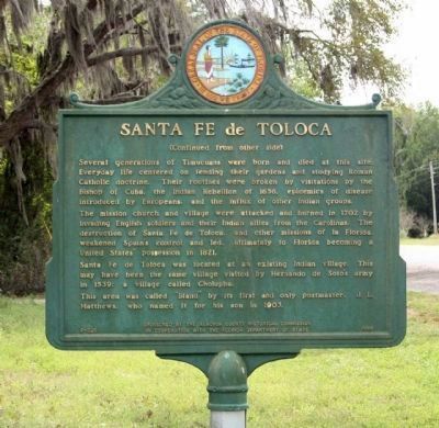
A Spanish Mission was established near here within sight of the Santa Fe River about A.D. 1606 by Franciscan missionaries. The river took its name from the mission, as did the modern town of Santa Fe. At one time, Santa Fe de Toloca was said to be . . . — — Map (db m64880) HM
Near Southeast 15th Street (Camp Ranch Road), 0.4 miles south of Southeast 41st Avenue when traveling south.
Hacienda de la Chua
Organized cattle ranching at the prairie began here in the 1600s. You are standing at the site of the largest ranch in Spanish Florida, Hacienda de Ia Chua (right). Hacienda de la Chua was the main supplier of beef to St. . . . — — Map (db m126488) HM
Near Southeast 15th Street (Camp Ranch Road), 0.4 miles south of Southeast 41st Avenue when traveling south.
The Alachua Sink, a named likely derived from the Potano word meaning “jug,” is the deepest of Paynes Prairie’s sinkholes and acts as a conduit for water entering the Floridan aquifer at a rate of up to 6 million gallons per day. . . . — — Map (db m126294) HM
On NW 83rd Street north of North West South Road, on the left when traveling north.
It’s August 13, 1539…
Hernando de Soto and his scouting party are passing through the Indian villages of Utinamocharra located just south of here –
My army of more than 700 men follow behind. We will march quickly through . . . — — Map (db m126581) HM
Near Northwest 34th Street (Florida Route 121) at Northwest 10th Avenue, on the right when traveling north.
(Front)
Hogtown Settlement
Near this site was located Hogtown, one of the earliest settlements in Alachua County. It was originally an Indian village which in 1824 had fourteen inhabitants. Hogtown settlement is also mentioned in . . . — — Map (db m150806) HM
On E. University Avenue, on the right when traveling west.
Present-day Gainesville was the center of a large Spanish cattle ranching industry, founded on the labor of native Timuqua Indians, during the 1600s. LaChua, largest of the ranches, was a Spanish corruption of an Indian word, and in turn was . . . — — Map (db m72916) HM
On Village Drive at Southwest 2nd Avenue (State Road 26A), on the right when traveling north on Village Drive. Reported permanently removed.
100 yards west is an aboriginal burial mound built ca. A.D. 1000 by Alachua Tradition peoples, ancestors of the Potano Indians who lived in Alachua County in the 16th and 17th centuries. Initially several individuals were buried in a central grave, . . . — — Map (db m134742) HM
On Village Drive south of Southwest 2nd Avenue (State Road 26A), on the right when traveling north.
(side 1)
Timucua Burial Mound
This earthen mound pays tribute to the ancestors of the Timucua Indians who lived and established villages near lakes and other sources of fresh water in north central Florida. Around 950 CE, following . . . — — Map (db m134740) HM
Gainesville is part of the traditional homelands of the Potano people, a Timucua-speaking society. The Timucua people lived here since time immemorial. Indigenous peoples from other nations long inhabited the area around what is now called . . . — — Map (db m220713) HM
Near SE Oleno Park Road, 2 miles east of US Highway 41 (U.S. 441) when traveling east.
It’s August 15, 1539…
Hernando de Soto and his scouts arrive at the Indian village of Cholupaha. It lies along the present-day Santa Fe River, which runs through here –
My Men captured several Indians and questioned them . . . — — Map (db m126582) HM
On Southeast Tuscawilla Road, 0.3 miles west of U.S. 441, on the right when traveling west.
The Battle of Micanopy
The Battle of Micanopy took place on the morning of June 9, 1836. Seventy-five troops under the command of Major J.F. Heileman engaged a larger Seminole force headed by Osceola, numbering about 250 warriors. Two . . . — — Map (db m150458) HM
On Northeast 1st Street (County Route 25A) at Northeast Peach Avenue, on the left when traveling north on Northeast 1st Street. Reported permanently removed.
A Timucua Indian village of the Potano tribe was located near here when the early Spanish Explorer Hernando De Soto led his expedition through the area in 1539. Botanist William Bartram visited Cuscawilla village nearby in 1774. The first permanent . . . — — Map (db m149338) HM
On Southeast Tuscawilla Road, 0.3 miles west of U.S. 441, on the right when traveling west.
War on the Frontier
The opening of the Second Seminole War began during the first week of December 1835. Seminole, along with their Black allies, attacked and burned hundreds of farms and homesteads in the Payne's Prairie region, the . . . — — Map (db m150459) HM
On Southeast Tuscawilla Road, 0.3 miles west of U.S. 441, on the right when traveling west.
Seminoles in Florida
Between 1716 and 1763, under pressure from the colonial powers of Britain and Spain, two groups of Creek Indians from more northerly regions of Spanish La Florida (see map) arrived in the area of present-day Micanopy . . . — — Map (db m150457) HM
Near Interstate 10 at milepost 318,, 0.6 miles west of 17 Mile Camp Road, on the right when traveling east.
Did you know the first people in North Florida lived here 10,000 years ago?1562
Timucuans
The Timucuans were the Native Floridians living in north and central Florida when the Europeans arrived in 1562. Powerful and . . . — — Map (db m159960) HM
Near Chestnut Avenue at 9th Street, on the right when traveling south.
In this park are the remains of a Native American settlement occupied sometime between AD 1200 and 1500. Archaeological studies at this site, called the Buena Vista Site 8BY878 documented that this was probably a small, temporary settlement where . . . — — Map (db m245323) HM
On West 10th Street at Beck Avenue, on the right when traveling east on West 10th Street.
When the Spanish passed through between the years 1516 and 1558, this area was inhabited seasonally by the Chatot and Yuchi Native American tribes. Shortly after contact, the Chatot became extinct (as did more than 90% of Florida native . . . — — Map (db m245641) HM
On Lighthouse Road north of Control Tower Road, on the left when traveling north.
The earliest evidence of human habitation on Cape Canaveral dates back about 6,000 years. Descendants of these first humans, the Ais, inhabited Cape Canaveral along with the nearby islands and the mainland.
There are 95 recorded sites within the . . . — — Map (db m217573) HM
On Center Street at Sevilla Court, in the median on Center Street.
Before modern construction a complex of six burial mounds occupied this location. They were built by the ancestors of the prehistoric Ais tribe, a group who occupied the Cape Canaveral area at the time of European contact. Based on pottery styles . . . — — Map (db m243353) HM
On Lighthouse Road north of Control Tower Road, on the left when traveling north.
Beginnings of Settlement
In the 1500s European explorers, slavers and missionaries first came to Cape Canaveral. Here they found a Native American population which had disappeared by 1730. The area remained sparsely populated until a . . . — — Map (db m217567) HM
On West King Street (State Road 520) west of South Cocoa Boulevard (U.S. 1), on the right when traveling west.
One half mile to the west ran the Hernandez Trail used during the Seminole War. It connected forts along the East Coast to Ft. Dallas in Miami and across from Ft. Pierce and Ft. Capron to Ft. Brooke near Tampa. Brig. General Joseph M. Hernandez, . . . — — Map (db m72606) HM
On Ramp Road, 0.2 miles west of South Brevard Avenue, on the left when traveling west.
The Thousand Islands formed as the result of an ancient tidal inlet that breached this barrier island and flowed across modern-day Cocoa Beach. The indigenous Ais people, a fisher-gatherer society, lived along the inlet. Their oyster-shell middens . . . — — Map (db m112180) HM
In 1605 Florida's Spanish Governor Pedro de Ybarra sent Lt. Alvaro Mexia on a diplomatic mission to the Ais Indians. Mexia recorded his passage from St. Augustine down the coast to the principal Ais Indian town near present-day Vero Beach. At the . . . — — Map (db m82927) HM
Near Thomas Barbour Drive, 0.5 miles north of U.S. 1.
The Ais Indian town of Pentoaya is thought to have been located atop the arc-shaped sand bluffs that surround the western edge of what is now Ballard Park. Pentoaya was an important prehistoric Indian settlement on the east coast of Florida, and was . . . — — Map (db m82819) HM
Near South Sykes Creek Parkway at Fortenberry Road.
Over three years from 2013-16, Navy veteran Jim McDole, of part Choctaw and Cherokee Heritage, carved this magnificent first buffalo hunt from a large block of fallon Chinese tallow. McDole was a homeless veteran during most of his labors. The . . . — — Map (db m164840) WM
On Sykes Creek Parkway at Old Audubon Road, on the right when traveling south on Sykes Creek Parkway.
The Ais were one of the most influential and powerful tribes in Florida when Spanish Army Lt. Alvaro Mexia mapped Ulumay Lagoon in 1605. He wrote in his diary “Here is the town of Ulumay, the first one of the province of Ais. In back of and . . . — — Map (db m72602) HM
Native Americans, explorers and settlers hauled or carried canoes and small boats over this narrow strip of land between Mosquito Lagoon and the Indian River. Eventually it became known as the “haulover.” Connecting both bodies of water . . . — — Map (db m108012) HM
On Windover Way at Windover Trail on Windover Way.
Discovered by accident in 1982, the Windover site is a burial place of Early Native Americans who inhabited this region 7,000 to 8,000 years ago. The burials were placed underwater in the peat of the shallow pond. This peat helped to preserve . . . — — Map (db m60342) HM
Near Southeast 6th Avenue at Southeast 4th Avenue, on the right when traveling south.
On this spot, January 31, 1893, Frank Stranahan, the founder of this city, conducted a ferry across New River, established a trading post with the Indians and operated the first U.S. Post Office.
Seven tenths of a mile west of this point . . . — — Map (db m100795) HM
Bahia Mar is the site of a haulover where Indians took their canoes from New River Sound into the Atlantic Ocean. A Second Seminole War fort named for Major William Lauderdale was built near here in 1838. It was active until the War ended in 1842. . . . — — Map (db m47419) HM
Near Southeast 6th Ave at Southeast 4th Avenue, on the right when traveling south.
Born at White Springs, Florida, on the banks of the Suwannee River, came to Fort Lauderdale, Florida in 1899 as the town's first school teacher. She married Frank Stranahan in 1900 and lived at the Indian Trading Post on New River, where she . . . — — Map (db m100385) HM
On Southwest 11th Avenue at Southwest 4th Street, on the left when traveling south on Southwest 11th Avenue.
The prehistoric peoples of Fort Lauderdale, commonly known as the Tequesta, occupied camps as early as 500 BCE in the area now known as Sailboat Bend. By 1800, Seminole Indians and Bahamian and American settlers inhabited lands along New River. In . . . — — Map (db m100394) HM
On Southwest 9th Avenue at Coconut Drive, on the right when traveling north on Southwest 9th Avenue.
The Tequesta Indians and their ancestors lived and traveled along the New River for at least 5000 years. The Tequesta were Native Americans that lived in Southeast Florida in an area that extended from Boca Raton to Key West encompassing the . . . — — Map (db m100444) HM
Near U.S. 441 at Stirling Road (State Road 848), on the right when traveling south.
The Council Oak Tree Site reflects the Seminole Tribe of Florida's growth over the years and stands as a symbol of strength and stability. The Council Oak Tree was the site of the meetings that led to the creation of the Seminole Tribe of Florida . . . — — Map (db m100134) HM
Bird Sanctuary
This mound was constructed as a place for ceremonial burial by prehistoric Indians about the year 1300 A.D.- It is believed that they were ancestors of the tribe known as the "TEQUESTA INDIANS"
Given to the people of Pompano . . . — — Map (db m128278) HM
On Hibiscus Avenue, 0.1 miles west of State Road A1A, on the right when traveling north.
Side One:
The Pompano Beach Indian Mound is a prehistoric sand burial mound that was used by the Tequesta tribe and their ancestors for burial of their dead. Located nearby was their associated village and midden dating as far back as AD . . . — — Map (db m100403) HM
On Central Avenue (State Road 20) at Main Street (State Road 71), on the right when traveling west on Central Avenue.
This is the western boundary of a reservation set aside by the treaty of Fort Moultrie and given to John Blunt (Blount) one of the six principal chiefs of the Florida Indians. The Apalachicola River was the eastern boundary. The treaty was ratified . . . — — Map (db m78029) HM
On East Central Avenue (State Road 20) at Main Street (State Road 71), on the right when traveling west on East Central Avenue.
(This is Florida's first bi-lingual marker. The second language is Apalachicola Muskogee/Creek.) Apalachicola Creek Indians permanently settled Calhoun County in 1815; wars forced them out of Alabama. A new Tribal Town was built by Chief Tuskie . . . — — Map (db m48489) HM
Near Tamiami Trail (U.S. 41) 0.1 miles south of County Route 776A.
In 1905, Clarence Bloomfield Moore (1852-1936), a wealthy, amateur archaeologist from Philadelphia excavated a mound located on the northern bank of the Peace River about one half mile north of this site. Moore found the sand burial mound containing . . . — — Map (db m152615) HM
On Ponce de Leon Parkway, 0.9 miles west of Colony Point Drive, on the right when traveling south.
On this day, May 24, ships were sent to seek a mainland colony site and to sound and chart the newly found “Bay of the Holy Spirit” (Charlotte Harbor). For three weeks explorations continued, seldom by land. There were at least three . . . — — Map (db m95500) HM
On Howard Street at Shore Drive, on the left when traveling north on Howard Street.
Frederick William Howard of Kinderhook, New York, first settled near this site in November 1873. After their marriage, Frederick and his wife Anna established residence here in January 1874, along with their two nephews. Frederick hired men and an . . . — — Map (db m167522) HM
On Ponce De Leon Parkway, 0.6 miles south of North Marion Court when traveling south. Reported missing.
In Charlotte Harbor Ponce de Leon came upon an urban Indian culture over 200 years old! The Caloosas were "City dwellers" whose sea-oriented high, dry, airy rectangular dwelling mounds made pleasant and secure homesites. Skillful engineers, the . . . — — Map (db m167684) HM
On Ponce de Leon Parkway, 0.6 miles south of North Marion Court, on the left when traveling south. Reported permanently removed.
On his first voyage to Florida in 1513, Juan Ponce de Leon spent several weeks at or near the mouth of Charlotte Harbor. When attacked by Indians he returned to Puerto Rico. In 1521, Ponce de Leon, with two shiploads of colonists, returned to . . . — — Map (db m167594) HM
On Ponce de Leon Parkway, 0.5 miles south of North Marion Court, on the right when traveling south. Reported missing.
The first European settlement in what is now the United States was established on the shores of Charlotte Harbor by explorer Juan Ponce de Leon and a band of more than 200 soldiers, priests, farmers, artisans and monks. The colony lasted for about . . . — — Map (db m167676) HM
Near East Orange Avenue (County Road 48) just east of South Florida Avenue (U.S. 41), on the left when traveling east.
[north-facing kiosk panel] Introduction Records of colonial explorers reveal a well-developed Native American trail linking the Tampa Bay area to the village of Alachua, 150 miles to the north. A Timucuan village existed along this . . . — — Map (db m168617) HM
On East Orange Avenue / South Duval Island Drive east of South Shore Acres Point, on the right when traveling east.
It’s July 24, 1539…
Hernando de Soto’s army has set up camp at a nearby Indian village, Tocaste -
I moved ahead with a small scouting party. Just north of the village, we discovered a broad road, which I believe may be the entrance . . . — — Map (db m126576) HM
Near South Florida Avenue (U.S. 41) 0.5 miles north of East Fort Cooper Road, on the right when traveling north.
More than 1,500 soldiers died and $20 million was spent in the Second Seminole War. It was the most costly of three conflicts between the U.S. and the Seminoles in Florida. Fought from 1835–1842, the war broke out when Seminoles resisted . . . — — Map (db m101818) HM
Near East Turner Camp Road (County Road 581) at Parker Street, on the right when traveling north.
It’s July 26, 1539…
An advance guard of Hernando de Soto’s army has moved through a nearby area and crossed the present-day Withlacoochee River -
It took us two days to cross the river. The rest of our army soon followed. Weighed . . . — — Map (db m126578) HM
Near Old Floral City Road, 0.2 miles south of Carnegie Drive, on the right when traveling south.
Prior to the Spanish arrival in the 1500s, there were hundreds of thousands of Native Americans living in Florida. Evidence of their diverse culture has been discovered in the mounds, earthworks, middens and other archaeological sites found . . . — — Map (db m132271) HM
Near Old Floral City Road, 0.2 miles south of Carnegie Drive, on the right when traveling south.
Setting the Scene In the Spring of 1836, President Andrew Jackson ordered General Winfield Scott, commander of the U.S. Army in Florida, to punish and defeat the belligerent Seminoles. Gen. Scott devised a complicated plan in which three . . . — — Map (db m132055) HM
Near Old Floral City Road, 0.2 miles south of Carnegie Drive, on the right when traveling south.
Adapting to Life in the Cove Necessities of Life Before the Seminole were forced to move to the Cove, they were farmers and ranchers who lived in sturdy log homes and based their wealth on large herds of cattle and extensive crops. Unlike the . . . — — Map (db m132276) HM
Near Old Floral City Road, 0.2 miles south of Carnegie Drive, on the right when traveling south.
The Siege of Fort CooperA Hastily Built Defense In March 1836, General Winfield Scott launched a campaign to surround the Seminole in the Cove with an army of approximately 5,000 men. While marching to Fort Brooke in Tampa they stopped . . . — — Map (db m132281) HM
Near East Dampier Street east of North Mill Avenue when traveling east.
It’s July 25, 1539…
Captain Moscoso is leading Hernando de Soto’s army north, from the village of Tocaste, to support De Soto’s scouting party…
Passing near a large lake, we were met by messengers sent by De Soto. They told us the . . . — — Map (db m126577) HM
Near Old Floral City Road, 0.2 miles south of Carnegie Drive, on the right when traveling south.
Seminole Migration Story of Survival The Seminole are descendants of the Muscogee group consisting primarily of Creek Indians from Georgia and Alabama. In the early 1700s, various bands of Creeks and other Muskogean peoples began to migrate . . . — — Map (db m132273) HM
Near Old Floral City Road, 0.2 miles south of Carnegie Drive, on the right when traveling south.
The Second Seminole War BeginsA Year of Victory for the Seminole In the early 1830s pressure to remove Florida's Indians grew intense. Seminole leaders signed treaties in 1832 and 1833 that called for the tribe to relocate within three . . . — — Map (db m132277) HM
Near Tamiami Trail East (U.S. 41) just south of San Marco Road (County Route 92), on the right when traveling south.
Once, occupied by the Caloosa Indians and the Spanish, it was the last refuge of the Seminoles. The region is drained in a north-south direction by creeks, rivers, sloughs and swamps. Abounding in wildlife, trees, plants, shrubs and flowers, most of . . . — — Map (db m194947) HM
In the early 1800s, the Seminole tribe sought and found refuge deep in the bald cypress forests of Southwest Florida during the Seminole Wars. This tree bears the Seminole name for big cypress, Asteenahoofa. It is straight, solid and free of . . . — — Map (db m164916) HM
On 8th Street South at 12th Avenue South on 8th Street South.
The Naples Canal was a monumental prehistoric construction achievement. It was 4,150 feet long (0.8 miles) and bisected an area between the Gulf of Mexico and Naples Bay. The Naples Canal was dug perhaps as early as A.D. 200 by local American . . . — — Map (db m127697) HM
On Tamiami Trail East (U.S. 41) at Monument Road, on the right when traveling west on Tamiami Trail East.
On February 22, 1936, this pine hammock was the site of a conference attended by about 275 Seminoles and several representatives of state and local governments. Florida's New Deal governor, David W. Sholtz (1933-37), had aided the state's economic . . . — — Map (db m190699) HM
Near SW Elim Church Road (County Road 238) 0.2 miles east of SW Ichetucknee Avenue, on the right when traveling east.
It’s August 17, 1539…
When Hernando de Soto’s scouts sight the abandoned Indian village of Caliquen, Cavalry Captain Baltasar de Gallegos is ordered to move ahead –
My men and I were sent to check for food and supplies. When . . . — — Map (db m127006) HM
On Northwest Falling Creek Road (County Road 131) 0.9 miles north of US Highway 41 (State Road 100), on the right when traveling north.
It’s September 10, 1539…
Conquistador Hernando de Soto has come to Uriutina, a deserted Indian village near here.
We have feasted upon the bounty of food left behind by the fleeing villagers. Messengers sent by Chief Uzachile have . . . — — Map (db m126584) HM
On U.S. 17, 0.2 miles south of Southwest River Street, on the right when traveling south.
As white settlers moved into Florida, demands increased for the removal of the Seminole Indians to a western reservation. The Seminoles failed to cooperate, and in 1835 the conflict known as the Second Seminole War began. By 1841, the Indians . . . — — Map (db m72605) HM
On County Road 351, 2.4 miles north of 1st St, Horseshoe Beach, on the left when traveling south.
On December 26, 1817, U.S. Secretary of War John C. Calhoun directed General Andrew Jackson to protect citizens trying to settle in Florida. Jackson arrived in Florida with the largest army ever to invade the state to date -- 2,000 Creek Warriors . . . — — Map (db m61566) HM
On U.S. 19 at State Road 349, on the right when traveling west on U.S. 19.
Inhabited by the Upper Creeks, Oldtown, often called Suwanee Oldtown, was one of the largest Indian villages in northern Florida. In Andrew Jackson's punitive expedition into Florida in April, 1818, Oldtown was captured. Most of the renegade Indians . . . — — Map (db m17712) HM
On Heckscher Drive (State Road 1A) south of Fort George Road, on the right when traveling south.
Jean Ribaut and a party of Huguenots landed the morning of May 1, 1562 on this island. Here they knelt in prayer, beseeching God's guidance and commending the natives to his care. This was the first Protestant prayer in North America. — — Map (db m40024) HM
On Ft. Caroline Road, on the left when traveling east.
"[H]aving landed [on the River of May's shore]... we saw the chief of that country, ... he ... showed such enthusiasm that he almost lost his composure. He came up to us... repeating ...'friend, friend.'" Captain René de Laundonnière, 1564 . . . — — Map (db m46555) HM
Near Ft. Caroline Road, on the left when traveling east.
"[The Timucuans] brought us grains of roasted maize,... smoked lizards or other wild animals... and various kinds of roots, some for foods, others for medicine. And when they discovered that we were more interested in metals and minerals, they . . . — — Map (db m46571) HM
Near Ft. Caroline Road, on the left when traveling east.
Bound by the Nassau River, the Atlantic Ocean, and the St. Johns River, the Timucuan Ecological and Historic Preserve seeks to protect much of the water and undeveloped land you see from here. Salt marsh, coastal hammock, tidal creeks, and sea and . . . — — Map (db m46576) HM
On North Julia Street at West Monroe Street, on the left when traveling north on North Julia Street.
Site of the ancient
Timuquan Indian town
of
Ossachite
from earliest times
until about 1700
Jacksonville Historical Society
1931 — — Map (db m148637) HM
Near East Main Street (County Road 196) at South Alcaniz Street, on the right when traveling east.
(Left panel)
De Soto Trail
1539-1540
You are standing along the historic route of the conquistador Hernando de Soto and his expedition through the Florida Native American territories in his quest for gold and glory. . . . — — Map (db m126595) HM
A native of Spain, Don Manuel Gonzalez joined the army at Madrid and was sent to New Orleans. After his discharge he was granted passage through the Choctaw and Creek Nations to Pensacola. At Pensacola, he was a successful cattle rancher. He opened . . . — — Map (db m80051) HM
On South 10th Avenue, 0.1 miles north of East Colfax Street, on the right when traveling north.
(Side 1)
The Hawkshaw site has supported prehistoric and historic occupations which span a period of nearly 2,000 years. It was inhabited around A.D. 150 by groups of Native Americans whom archaeologists call the Deptford Culture. Scientific . . . — — Map (db m72238) HM
On Bay Parkway (Florida Route 196), on the right when traveling east.
Archaeology has helped us learn a lot about life in prehistoric Pensacola.
Although little archaeological evidence exists from Pensacola's earliest
Paleoindian residents, sites from later periods reveal a strong reliance on the
marine landscape. . . . — — Map (db m177091) HM
On South Spring Street at Main Street, on the right when traveling north on South Spring Street.
Indian trading post
established during the English occupation
1763-1783
and burial place of
Alexander McGillivray.
Born Ft. Toulouse, Ala. 1746
Died Pensacola, Fla. 1793
Made Chief of Creek Nation 1776
Commissioned British . . . — — Map (db m170763) HM
Near Fort Pickens Road, 9.5 miles west of Pensacola Beach Boulevard (Road 399), on the right when traveling west.
In 1886 the U.S. Army exiled 400 Apaches from the Southwest to Florida and sent most of them to Fort Marion in St. Augustine. Several Pensacola citizens, however, petitioned the government to imprison Geronimo, a medicine man and warrior, and 15 . . . — — Map (db m86084) HM
Near Bulow Plantation Ruins, 1 mile east of Old Kings Road.
The Bulow Ville plantation house was built in the early 1820s and believed to have resembled the mansion shown. The two and a half story building faced Bulow Creek and had a veranda on all sides. The first floor walls were coquina covered with . . . — — Map (db m191597) HM
Near North Ocean Shore Boulevard (Florida Route A1A) at Poole Drive, on the left when traveling south.
What’s That Rock on the Beach?
What is that rock growing out of the beach sand? This is Coquina (ko-key-nah), Spanish for “little shell.” Coquina rock is a mixture of shells and quartz sand. It was formed by nature hundreds . . . — — Map (db m153622) HM
Near North Ocean Shore Boulevard (Florida Route A1A) at Whitney Drive, on the left when traveling south.
Prehistoric Garbage Piles
The Native Americans that lived here for thousands of years are known only from the middens and mounds they left behind. Imagine if there were no big trucks to haul your garbage away. What if you simply tossed your . . . — — Map (db m153634) HM
Near N Ocean Shore Boulevard (National Route A1A) 0.1 miles north of Mala Compra Drive.
Joseph Hernandez was a significant person in early Florida, with a fascinating life. Part of it was spent at his Mala Compra Plantation, and the main buildings were located on this site.
Planter
Joseph Hernandez acquired three . . . — — Map (db m208294) HM
Near North Ocean Shore Boulevard (Florida Route A1A) 0.1 miles north of Mala Compra Drive, on the left when traveling north.
Seminoles Become Residents of Florida
Groups of lower Creeks began moving into Florida from central Georgia about 1715. Fifty years later they had established a separate identity as Seminoles. Seminoles were not a united tribe but a group . . . — — Map (db m209524) HM
On Avenue B South (Business U.S. 98) east of Marine Street, on the right when traveling west.
Jebediah Tate was a superstitious farmer that lived northwest of Carrabelle in Sumatra Florida. His only son was born just before the war and he named him Cebe. Jebediah was a Civil War veteran, and his wife was half Cherokee Indian. He bought 160 . . . — — Map (db m122000) HM
During a storm in 1799, the schooner Fox ran aground off the eastern end of St. George Island. On board was William Augustus Bowles, a British citizen and self-styled leader of the Creek-Cherokee nation. Bowles was bringing gunpowder and bullets, he . . . — — Map (db m52650) HM
Near Forest Road 127, 4 miles west of State Road 65, on the right when traveling south.
(obverse)
Francis the Prophet, whose Indian name was Hillis Hadjo, was an important Creek chief who was forced to leave his home in the Alabama Territory at the end of the Creek War of 1813-14. He established a new town on the Wakulla River . . . — — Map (db m114624) HM
On South River Landing Road, 0.5 miles south of West Washington Street (U.S. 90), on the right when traveling south.
This prehistoric mound is the largest of seven that once stood here at River Landing Park. Believed to date from the Fort Walton time period (A.D. 900-A.D. 1500), its original appearance was that of a flat-topped pyramid. Archaeologists believe that . . . — — Map (db m110893) HM
On River Landing Road, 0.3 miles south of U.S. 90, on the left when traveling west.
The 1795 Treaty of San Lorenzo defined the international border dividing Spanish Florida from the newly formed United States.
No one who signed the treaty had ever seen it, but the point of land formed by the confluence of the Chattahoochee and . . . — — Map (db m230733) HM
On River Landing Road, 0.3 miles west of West Washington Street (U.S. 90), on the left when traveling west.
Chattahoochee River Landing Park-An Apalachicola River Heritage Destination
This restored mound helps you visualize the original appearance of the seven prehistoric mounds that archaeologists believe stood here. Native Americans started . . . — — Map (db m216211) HM
On River Landing Road, 0.4 miles south of U.S. 90, on the right when traveling south.
British troops arrived here in June 1814 as the War of 1812 entered its closing months. Initially, they worked to recruit and train Native American (Red Stick Creek, Seminole, Miccosukee, and Yuchi) warriors as auxiliaries.
The Apalachicola River . . . — — Map (db m231607) HM
On South River Landing Road, 0.5 miles south of West Washington Street (U.S. 90), on the right when traveling south.
Atop this large prehistoric mound stood Nicolls' Outpost, a British fort of the War of 1812. Built in the fall of 1814, it was a rectangular earthen redoubt with a surrounding stockade and was armed with two small cannons. Garrisoned by 180 white . . . — — Map (db m79455) HM
On River Landing Road, 0.2 miles south of U.S. 90, on the left when traveling south.
At the end of the American Revolutionary War in 1783, Florida was returned to Spain after twenty years of British control. Controversy soon arose over the exact location of the boundary between Spanish Florida and the state of Georgia. In 1795, . . . — — Map (db m79444) HM
On River Landing Road, 0.4 miles south of U.S. 90, on the right when traveling south.
River Landing Park is sacred ground. A major culture flourished here more than 1,000 years ago, building a complex of at least seven platform mounds. The largest of these earthworks stands before you.
Construction of the mounds began nearly 2,000 . . . — — Map (db m231609) HM
On River Landing Road, 0.4 miles south of U.S. 90, on the right when traveling south.
The First Seminole War erupted when U.S. soldiers attacked the Lower Creek village of Fowltown near today's Bainbridge, Georgia, on November 21-23, 1817.
Native American and Maroon (escaped slave or Black Seminole) warriors retaliated by . . . — — Map (db m230902) HM
On River Landing Road, 0.4 miles south of U.S. 90, on the right when traveling south.
A bloody battle fought on this site more than 200 years ago helped assure that Florida would become part of the United States.
Angered over an attack by American soldiers on the Lower Creek village of Fowltown near today's Bainbridge, Georgia, . . . — — Map (db m231593) HM
On State Road 78 south of U.S. 27, on the right when traveling west. Reported missing.
In the Ortona cemetery, eight miles west of here, lie the remains of a noble citizen of the Seminole Tribe of Florida, a faithful representative of his people and a true friend of the white man. — — Map (db m218232) HM
Near Lillian Saunders Drive at Foster Barnes Drive, on the right when traveling south.
In the Upper Suwannee River Valley folks continue to make items for decorative and daily use. As local quilter Nancy Morgan says, "There's an art to everything you do." From christening dresses to gourd birdhouses, handmade items reflect the values, . . . — — Map (db m230356) HM
On Bridge Street (State Road 136) north of River Street, on the right when traveling north.
Florida's native Timucuan Indians lived for hundreds of generations in what is now north Florida and southeast Georgia. Beginning in the 1580s, they were organized into mission villages by Spanish Franciscan priests. While exploitation and . . . — — Map (db m44609) HM
On U.S. 41 (Local Road 25) just east of Wesson Street, on the right when traveling east.
These sulphur springs were thought to have medicinal properties and were considered sacred by the Indians. Warriors wounded in battle reputedly were not attacked when they came here to recuperate. Settlers moved into the vicinity in 1826 and the . . . — — Map (db m13675) HM
One of the Last Battles fought with the Seminole Nation ended here on June 16, 1856 with Defeat of the Indians by Soldiers from Ft. Meade. — — Map (db m61059) HM
Near Cortez Boulevard (County Road 550) 6.5 miles west of Commercial Way (U.S. 19), on the right when traveling west.
Bayport's Early Historic Period
During the First Spanish Period (1565-1763) Florida served as a military defense port. In 1763, under British control, agricultural commerce became important. Control of Florida returned to Spain in 1783. In . . . — — Map (db m93297) HM
Near Cortez Boulevard (County Road 550) 6.5 miles west of Commercial Way (U.S. 19).
(side 1)
The Bayport Area Before Human Occupation
The fossilized remains of many prehistoric animals and plants are buried in the Bayport area. During the Eocene Period, 45 million years ago (MYA), the Gulf covered this region. . . . — — Map (db m93296) HM
423 entries matched your criteria. The first 100 are listed above. Next 100 ⊳