By Mike Stroud, March 20, 2013
Santa Fe de Toloca Marker, reverse side
GEOGRAPHIC SORT Title Sort Marker Number Sort Marker Number Sort N Marker Number Sort T Publication Order Sort Publication Order Sort A Erected Year Sort Most Viewed Sort Most Recent-Interest Sort Most Recently Changed Sort SEE FAQ #33 FOR DESCRIPTIONS
On County Road 241 S near NW 294 Avenue, on the left when traveling south.
Near Southeast 15th Street (Camp Ranch Road), 0.4 miles south of Southeast 41st Avenue when traveling south.
Near Southeast 15th Street (Camp Ranch Road), 0.4 miles south of Southeast 41st Avenue when traveling south.
On NW 83rd Street north of North West South Road, on the left when traveling north.
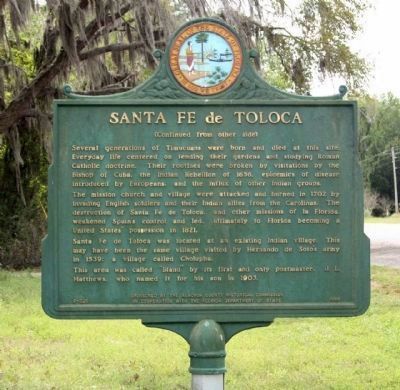
Near Northwest 34th Street (Florida Route 121) at Northwest 10th Avenue, on the right when traveling north.
On E. University Avenue, on the right when traveling west.
On Village Drive at Southwest 2nd Avenue (State Road 26A), on the right when traveling north on Village Drive. Reported permanently removed.
On Village Drive south of Southwest 2nd Avenue (State Road 26A), on the right when traveling north.
On East University Avenue.
Near SE Oleno Park Road, 2 miles east of US Highway 41 (U.S. 441) when traveling east.
On Southeast Tuscawilla Road, 0.3 miles west of U.S. 441, on the right when traveling west.
On Northeast 1st Street (County Route 25A) at Northeast Peach Avenue, on the left when traveling north on Northeast 1st Street. Reported permanently removed.
On Southeast Tuscawilla Road, 0.3 miles west of U.S. 441, on the right when traveling west.
On Southeast Tuscawilla Road, 0.3 miles west of U.S. 441, on the right when traveling west.
Near Interstate 10 at milepost 318,, 0.6 miles west of 17 Mile Camp Road, on the right when traveling east.
Paid Advertisement
Near Chestnut Avenue at 9th Street, on the right when traveling south.
On West 10th Street at Beck Avenue, on the right when traveling east on West 10th Street.
On Lighthouse Road north of Control Tower Road, on the left when traveling north.
On Center Street at Sevilla Court, in the median on Center Street.
On Lighthouse Road north of Control Tower Road, on the left when traveling north.
On West King Street (State Road 520) west of South Cocoa Boulevard (U.S. 1), on the right when traveling west.
On Ramp Road, 0.2 miles west of South Brevard Avenue, on the left when traveling west.
Near South Patrick Drive at Yacht Club Boulevard.
Near Thomas Barbour Drive, 0.5 miles north of U.S. 1.
Near South Sykes Creek Parkway at Fortenberry Road.
On Sykes Creek Parkway at Old Audubon Road, on the right when traveling south on Sykes Creek Parkway.
Near Courtenay Parkway North (State Road 3).
On Windover Way at Windover Trail on Windover Way.
Near Southeast 6th Avenue at Southeast 4th Avenue, on the right when traveling south.
Near Southeast 6th Ave at Southeast 4th Avenue, on the right when traveling south.
Paid Advertisement
Near South Andrews Avenue south of East Broward Boulevard, on the left when traveling south.
On Southwest 11th Avenue at Southwest 4th Street, on the left when traveling south on Southwest 11th Avenue.
On Southwest 9th Avenue at Coconut Drive, on the right when traveling north on Southwest 9th Avenue.
Near U.S. 441 at Stirling Road (State Road 848), on the right when traveling south.
Near Hibiscus Avenue at Southeast 13th Street.
On Hibiscus Avenue, 0.1 miles west of State Road A1A, on the right when traveling north.
On Central Avenue (State Road 20) at Main Street (State Road 71), on the right when traveling west on Central Avenue.
On East Central Avenue (State Road 20) at Main Street (State Road 71), on the right when traveling west on East Central Avenue.
Near Tamiami Trail (U.S. 41) 0.1 miles south of County Route 776A.
On Ponce de Leon Parkway, 0.9 miles west of Colony Point Drive, on the right when traveling south.
On Howard Street at Shore Drive, on the left when traveling north on Howard Street.
On Ponce De Leon Parkway, 0.6 miles south of North Marion Court when traveling south. Reported missing.
On Ponce de Leon Parkway, 0.6 miles south of North Marion Court, on the left when traveling south. Reported permanently removed.
On Ponce de Leon Parkway, 0.5 miles south of North Marion Court, on the right when traveling south. Reported missing.
Near East Orange Avenue (County Road 48) just east of South Florida Avenue (U.S. 41), on the left when traveling east.
On East Orange Avenue / South Duval Island Drive east of South Shore Acres Point, on the right when traveling east.
Paid Advertisement
Near South Florida Avenue (U.S. 41) 0.5 miles north of East Fort Cooper Road, on the right when traveling north.
Near East Turner Camp Road (County Road 581) at Parker Street, on the right when traveling north.
Near Old Floral City Road, 0.2 miles south of Carnegie Drive, on the right when traveling south.
Near Old Floral City Road, 0.2 miles south of Carnegie Drive, on the right when traveling south.
Near Old Floral City Road, 0.2 miles south of Carnegie Drive, on the right when traveling south.
Near Old Floral City Road, 0.2 miles south of Carnegie Drive, on the right when traveling south.
Near East Dampier Street east of North Mill Avenue when traveling east.
Near Old Floral City Road, 0.2 miles south of Carnegie Drive, on the right when traveling south.
Near Old Floral City Road, 0.2 miles south of Carnegie Drive, on the right when traveling south.
Near Tamiami Trail East (U.S. 41) just south of San Marco Road (County Route 92), on the right when traveling south.
Near Sanctuary Road West at Rookery Lane.
On 8th Street South at 12th Avenue South on 8th Street South.
On Tamiami Trail East (U.S. 41) at Monument Road, on the right when traveling west on Tamiami Trail East.
Near SW Elim Church Road (County Road 238) 0.2 miles east of SW Ichetucknee Avenue, on the right when traveling east.
On Northwest Falling Creek Road (County Road 131) 0.9 miles north of US Highway 41 (State Road 100), on the right when traveling north.
On U.S. 17, 0.2 miles south of Southwest River Street, on the right when traveling south.
Paid Advertisement
On County Road 351, 2.4 miles north of 1st St, Horseshoe Beach, on the left when traveling south.
On U.S. 19 at State Road 349, on the right when traveling west on U.S. 19.
On Heckscher Drive (State Road 1A) south of Fort George Road, on the right when traveling south.
On Ft. Caroline Road, on the left when traveling east.
Near Ft. Caroline Road, on the left when traveling east.
Near Ft. Caroline Road, on the left when traveling east.
On North Julia Street at West Monroe Street, on the left when traveling north on North Julia Street.
Near East Main Street (County Road 196) at South Alcaniz Street, on the right when traveling east.
Near North Alcaniz Street at W.D. Childers Plaza.
On South 10th Avenue, 0.1 miles north of East Colfax Street, on the right when traveling north.
On Bay Parkway (Florida Route 196), on the right when traveling east.
On South Spring Street at Main Street, on the right when traveling north on South Spring Street.
Near Fort Pickens Road, 9.5 miles west of Pensacola Beach Boulevard (Road 399), on the right when traveling west.
Near Bulow Plantation Ruins, 1 mile east of Old Kings Road.
Near North Ocean Shore Boulevard (Florida Route A1A) at Poole Drive, on the left when traveling south.
Near North Ocean Shore Boulevard (Florida Route A1A) at Whitney Drive, on the left when traveling south.
Paid Advertisement
Near N Ocean Shore Boulevard (National Route A1A) 0.1 miles north of Mala Compra Drive.
Near North Ocean Shore Boulevard (Florida Route A1A) 0.1 miles north of Mala Compra Drive, on the left when traveling north.
On Avenue B South (Business U.S. 98) east of Marine Street, on the right when traveling west.
Near Forest Road 127, 4 miles west of State Road 65, on the right when traveling south.
On South River Landing Road, 0.5 miles south of West Washington Street (U.S. 90), on the right when traveling south.
On River Landing Road, 0.3 miles south of U.S. 90, on the left when traveling west.
On River Landing Road, 0.3 miles west of West Washington Street (U.S. 90), on the left when traveling west.
On River Landing Road, 0.4 miles south of U.S. 90, on the right when traveling south.
On South River Landing Road, 0.5 miles south of West Washington Street (U.S. 90), on the right when traveling south.
On River Landing Road, 0.2 miles south of U.S. 90, on the left when traveling south.
On River Landing Road, 0.4 miles south of U.S. 90, on the right when traveling south.
On River Landing Road, 0.4 miles south of U.S. 90, on the right when traveling south.
On River Landing Road, 0.4 miles south of U.S. 90, on the right when traveling south.
On State Road 78 south of U.S. 27, on the right when traveling west. Reported missing.
Near Lillian Saunders Drive at Foster Barnes Drive, on the right when traveling south.
Paid Advertisement
On Bridge Street (State Road 136) north of River Street, on the right when traveling north.
On U.S. 41 (Local Road 25) just east of Wesson Street, on the right when traveling east.
On Museum Drive near U.S. 17.
Near Cortez Boulevard (County Road 550) 6.5 miles west of Commercial Way (U.S. 19), on the right when traveling west.
Near Cortez Boulevard (County Road 550) 6.5 miles west of Commercial Way (U.S. 19).
423 entries matched your criteria. The first 100 are listed above.
Next 100 ⊳