It’s July 29, 1539…
De Soto’s weary and starving army arrives at the village of Ocale -
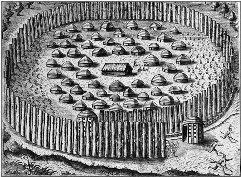
We found the village abandoned but full of food and supplies. I ordered my men to rest and then gather enough provisions for the next several . . . — — Map (db m126579) HM
In 1823, the Treaty of Moultrie Creek allocated land to the Seminole with the northern-most boundary of the reservation ending at what would soon be known as Fort King. Due to the growing friction between the Seminole and white settlers, the . . . — — Map (db m201370) HM
Who were "Americans" first? At least several hundred years before Crackers migrated from England and Scotland to the USA, and then wandered down the eastern seaboard to Florida in the 1800s Well before the Seminoles sought refuge in Florida . . . — — Map (db m167206) HM
December 28, 1835
The start of the Second Seminole War:
The second attack on that deadly day
Attack on Fort King
The same day as the Dade Massacre, the Fort King Indian Removal Agent, General Wiley Thompson, was anticipating . . . — — Map (db m201752) WM
Dade Massacre
Dec. 28, 1835
Major Francis L. Dade and 110 men were attacked six miles north of Withlacoochee River. Four survived and one lived to tell the story. Troop was en route to Ft. King.
Same day, Gen. Thompson and . . . — — Map (db m198813) HM WM
December 28, 1835
The start of the Second Seminole War:
The first attack on that deadly day
Dade Massacre
On December 23, 1835, two companies of U.S. troops were dispatched from Fort Brooke in Tampa under the . . . — — Map (db m201516) HM
It was the U.S. Army’s hope that forts and garrisons would be more self-sufficient and not depend on supplies from the Army. On September 11, 1818, a general departmental order stated, "the commanding officer of every permanent garrison. will . . . — — Map (db m202093) HM
Some of the early migrants to the Greenway were known for whips and storytelling. Discover what happened. Discover The Island. Florida’s Crackers were mostly, it's said to be, English pioneer settlers and their descendants who began coming to . . . — — Map (db m167205) HM
Florida Seminole. After the Third Seminole War (1858), nearly 3,000 Indians were forcibly sent to the Oklahoma Territory. A small number of Seminoles continued to live in relative isolation in southern Florida into the 1900s. Flood control and . . . — — Map (db m167203) HM
Early Migrants More Than Snowbirds The earliest migrants to Florida, determined by archeological evidence, date back to 500 A. D. Among them were the Deptford People, the Weeden Island People, the St. John's People and the Timican . . . — — Map (db m167202) HM
Fort King was a typical U.S. Army frontier fort and a noteworthy symbol of the longest and costliest war America had with its native people - the Seminole War. Fort King is a narrative that speaks of a complicated history as relates to the . . . — — Map (db m201351) HM
On a nearby knoll stood Fort King, important military outpost during the removal of the Florida Indians. Adjacent to a Seminole agency established in 1825, it was named for Col. William King and first occupied in 1827. Outside the stockade, on . . . — — Map (db m150855) HM
A timeless memorial to those who
Lost Their Lives
at Fort King.
In 1927, the Marion County Chapter of the Daughters of the American Revolution had the great forethought to sign a title transaction that deeded this . . . — — Map (db m221845) HM
In the 1800’s,communication, supply delivery and trade between the Indian Agencies, Seminole and U.S.
Army forts proved to be challenging due to the lack of a clear path or road. In many cases forests, difficult or impassable terrain and . . . — — Map (db m201485) HM
Life at Fort King would not have been easy for soldiers accustomed to a northern climate and more civilized setting. They would have experienced extreme heat and encountered insects and animals they were unfamiliar with. The soldiers' uniforms . . . — — Map (db m202035) HM
Navajo Indian Code Talkers
U.S.M.C.
Used their native language skills to direct U.S. Marine Corps artillery fire during WWII in Pacific area. Japanese could not break code thus these early Americans exemplified the spirit of . . . — — Map (db m199035) WM
In 1539 Spanish explorers under Hernando de Soto discovered in this vicinity a populous native country called Ocali. From this Timucuan name is derived Ocala, a designation distinctive among the oldest place-names of Florida. Marion County, named . . . — — Map (db m90554) HM
Oklahoma Seminoles. The Seminole Nation in the State of Oklahoma is the largest of the three recognized Seminole governments in the United States. They are descendants of the 3,000 Seminoles who were forcibly removed from Florida in the middle . . . — — Map (db m167204) HM
1st. Seminole War: 1817 - 1818
Warfare in south GA & Florida
Gen. Andrew Jackson led U.S. troops. Seminoles
we’re called Micos and we’re quickly defeated.
Spain ceded Florida to U.S. in 1821
2nd. Seminole War: 1835 . . . — — Map (db m198855) WM
Several years after the conclusion of the War of 1812, the U.S. military began excursions into the Spanish owned territory of Florida. General Andrew Jackson ordered his military to invade and destroy the “Negro Fort” on the Apalachicola River . . . — — Map (db m201473) HM
The Second Fort
Amidst growing hostilities with the Seminole, the U.S. Army reconstructed Fort King in 1837 and continued its use until the termination of the war. Unlike the first fort, the second fort appears to have been constructed in . . . — — Map (db m201408) HM
The Second Seminole War
After years of managing conflicts between the American settlers and Native Americans all along the east coast, the United States government passed the Indian Removal Act of 1830 which sought to relocate all . . . — — Map (db m201594) HM
The Seminole Wars, also known as the Florida Wars, were three related military conflicts in Florida between the Seminole and the United States. Many consider them one conflict called The Seminole War.
There is no absolute consensus to . . . — — Map (db m201430) HM
Shortly after Florida became American Territory, the conflict between the United States and the Seminole began to escalate. In 1823, the United States and the Seminole entered into an agreement known as The Treaty of Moultrie Creek.
The . . . — — Map (db m201600) HM
After George Washington disbanded the Continental Army in 1783, the United States Army had been reduced to 80 men under a captain guarding the arsenals at two forts. To many members of Congress, a standing army was viewed as a threat to . . . — — Map (db m201667) HM WM
In 1828, Andrew Jackson was elected President of the United States, in 1830, Congress passed and President Jackson signed into law the Indian Removal Act, which called for the relocation of all Native Americans to west of the Mississippi River the . . . — — Map (db m201518) HM
U.S. Territory of Florida
1822 - 1845
Territorial settlers were defended in
attacks from Seminoles and others by the
U.S. Army, Georgia Militia, volunteers and
Allied Indians
Sponsored by:
Descendants of our GGG + . . . — — Map (db m198997) HM WM
October 23, 1834, the Seminole Indians met in council at these springs to discuss demands of the United States for their removal to the West. Osceola, then an obscure sub-chief, swayed the council with his oratory and set the Indians against . . . — — Map (db m132200) HM
Timucuans At least 12,000 years ago, people who later became known as the Timucuans, in the Ocali province, were living here hunting large animals such as mastodon and giant sloths. At that time, the climate was much cooler and drier, sea level . . . — — Map (db m225879) HM
Three miles to the east on September 23, 1696, the British barkentine Reformation foundered off Jupiter Island. The 24 survivors included a party of Quakers bound from Jamaica to Pennsylvania. Leader of the Quakers was Jonathan Dickinson who . . . — — Map (db m14311) HM
Born in 1923, Betty Mae Tiger Jumper was the first Chairwoman of the Seminole Tribe of Florida, elected in 1967. She spent her early life with her parents, Ada Tiger and Abe Partan, at the Seminole camp in Indiantown. Tribal medicine men threatened . . . — — Map (db m148906) HM
A Marker for Millennia
A recognizable landmark on the west bank of the Indian River, the prominent rise we know today as Mount Elizabeth, is actually a collection of debris from a Late Archaic village over 4,200 years old. The Archaic . . . — — Map (db m150970) HM
Mount Elizabeth Mound was constructed approximately 4,000 years ago during the Late Archaic Period by Florida bands who selected this site for a ceremonial shell midden-mound. It was occupied 4,000-800 years ago by ancient peoples who first . . . — — Map (db m106567) HM
Europeans arriving at Hutchinson Island in the 16th century found the island populated by hundreds of Native Americans living in settlements bordering both the Atlantic Ocean and the Indian River.
The rich marine environment provided these . . . — — Map (db m106588) HM
Built in 1925 by R.l. Robb Construction Co. for the Golden Gate Development Company, this building is one of Martin County's most distinctive historical structures. The two-story, trapezoidal building was designed in the Mission/Mediterranean . . . — — Map (db m136029) HM
Through the collective recognition of the community of nations
expressed within the principles of the
convention concerning protection of the world,
cultural and natural heritage
Everglades National Park
has been designated a . . . — — Map (db m213490) HM
In the early 1820's, enslaved Africans, runaways, and "Black Seminoles" seeking freedom from slave catchers and plantation masters, secretly worked their way down to CAPE FLORIDA. They met with bold captains of sloops from the British Bahamas who . . . — — Map (db m79723) HM
Key Biscayne is a barrier island located at the north end of the reef-strewn Florida Straits. One thousand years before Columbus sailed, the Tequesta inhabited the island. These coastal fishermen navigated dugout canoes between the . . . — — Map (db m79666) HM
Archaeologists began work on Key Biscayne in 1985 and have uncovered hundreds of artifacts providing clues of human habitation beginning with the Tequesta Indians and continuing through the mid-nineteenth century. Ten archaeological sites are . . . — — Map (db m134806) HM
The Brickell Family donated Brickell Park to Miami in 1921 as a preserve for the family mausoleum. Their remains are now in Woodlawn Cemetery. Brickell Park is one of the few parks connecting Brickell Avenue to the shoreline of Biscayne Bay. From . . . — — Map (db m65647) HM
The United States of America took possession of Florida from Spain under the terms of the 1821 Treaty of Paris. In 1830, the U.S. implemented the Indian Removal Act, forcing Seminole Indians south into the Miami and Everglades area. The Second . . . — — Map (db m78126) HM
The Tamiami Trail changed life in South Florida forever. Crossing the state went from being a multi-day sea and train journey through the Keys to a motor car drive of only a few hours. It opened up access to an area that was considered by most to be . . . — — Map (db m132095) HM
The Tequesta Indians were the indigenous people of Miami prior to European contact. Mary Brickell Park encompasses a portion of what was the largest Tequesta village in southeast Florida. Archaeological evidence reveals that this site was in use . . . — — Map (db m65648) HM
Don Pedro Menendez de Aviles, Adelantado of Florida and founder of St. Augustine, landed here at the chief village of the Tequesta Indians early in 1567. He returned several Indians held captive on the West Coast and established friendly relations . . . — — Map (db m88324) HM
The Miami Circle site would not exist today if it were not for the support of the community. Public outcry over the impending destruction of the Miami Circle led to additional archaeological research and preservation of the 2.2 acre parcel of . . . — — Map (db m65471) HM
Indians lived at the mouth of the Miami River (200 yards southwest of this spot) for more than 15 centuries before White men came. The principal town of the Tequesta Indians, including six mounds used for dwelling, burial, and religious rites, was . . . — — Map (db m88322) HM
On this spot of land at the mouth of the Miami River, a historic discovery shed new light on one of Florida's early peoples - the Tequesta. During the demolition of the Brickell Point apartments in 1998, archaeologists uncovered preshistoric . . . — — Map (db m65644) HM
The Miami Circle at Brickell Point has been designated a National Historic Landmark This site possesses national significance in commemorating the history of the United States of America. The Miami Circle is a 38-foot diameter ring of post . . . — — Map (db m65646) HM
Brickell Point has been host to many cultures and witness to a number of historical milestones.
The powerful Tequesta Indians made their main village at the mouth of the Miami River for over two thousand years. Abundant natural resources . . . — — Map (db m65645) HM
Virginia Key Beach Park is an environmental and historic landmark located on a barrier island. Its earliest recorded history is of an 1838 skirmish during the Second Seminole War in which three Seminoles were killed on this site. From the early . . . — — Map (db m79381) HM
Until 1973, when it collapsed, the forty foot natural bridge of oolitic limestone that spanned Arch Creek was one of South Florida's earliest landmarks. Prehistoric Indians occupied this site hundreds of years before European exploration. In the . . . — — Map (db m77645) HM
The Arch Creek State Archaeological Site was listed on the National Register of Historic Places in 1985. It contains a portion of the Military Trail, a wagon road, built during the Third Seminole War (1855-1859) by the U.S. Army. In 1856 Captains . . . — — Map (db m77648) HM
Listed on the National Register of Historic Places since 1986, the Deering Estate at Cutler is a 444 acre environmental, archaeological, historical and architectural preserve owned by the State of Florida and managed by the Miami-Dade County Park . . . — — Map (db m187289) HM
(side 1)
In 1838, the United States Congress granted a township of land in the southern extremity of Florida to noted horticulturist Dr. Henry Perrine and his associates. This land was to be used in experiments aimed at introducing foreign . . . — — Map (db m73442) HM
Indian Key, an 11 acre island just offshore to the east, played an important part in Florida's history. An Indian village 1500 years ago, it was also the home of pirates roaming the Caribbean, and a ship wrecker's village during the 1810's. The . . . — — Map (db m176361) HM
Native Americans began occupying Indian Key by approximately A.D. 1000. It was visited by the Spanish during the 17th century, and a trading post had been established on the island by the early 19th century.
The island was acquired by Jacob . . . — — Map (db m224711) HM
When the Europeans arrived in America, two tribes of Indians were found in Florida, the Calusa and the Tequesta. These tribes emerged from the Archaic Period (the time when Florida became subtropical, around 5000 B.C.). The Calusa was the largest . . . — — Map (db m222295) HM
Indians lived on this island over 1000 years ago. In 1722, it was known as Boys Island. In Dec., 1838, Lt. Coste established a Naval base here and named it Ft. Paulding. This was the base for the West Indian Squadron used to blockade the coast to . . . — — Map (db m176362) HM
Like nearby Upper and Lower Matecumbe and Indian Keys, Tea Table Key was occupied by native Americans during prehistoric times. The early inhabitants settled here to take advantage of the abundance of maritime resources available in the area. . . . — — Map (db m224714) HM
Upper Matecumbe Key has been inhabited periodically since about 2000 B.C. Much has changed on the island, but the climate, the sea, and the relaxed lifestyle continue.
Island Natives
Long before European settlement of Florida, Upper . . . — — Map (db m224647) HM
1. North East end Lower Matecumbe Key - Ancient Water Wells - only fresh water on Upper Keys - Used by Indians, Sailors and Traders in XVII Century. Huge Indian Midden (Kitchen) near Wells.
2. Indian Key - Spanish Trading Post - established by . . . — — Map (db m83862) HM
Before 1492, Cuba was populated by at least two distinct indigenous peoples: Taino and Siboney (some consider these populations to be Neo-Taino Nations). These two groups were prehistoric cultures in a time period during which humans created . . . — — Map (db m243874) HM
Second Seminole War
Enraged by the government's imminent deadline for their removal to western reservations, Florida Indians launched attacks on military units and outlying plantations in December 1835.
First news of the attacks . . . — — Map (db m224141) HM WM
(side 1)
What is today Tavenier was originally inhabited by the Calusa and Tequesta Native Americans. The Tequesta occupied the area around Biscayne Bay, while the Calusa inhabited Southwest Florida. In 1513, the Florida Keys were . . . — — Map (db m129571) HM
This land high above the Amelia River was a campsite for Indians in pre-historic times, as early as 2000-1000 B.C. In the early history of the state, it assumed military importance because of the fine protected harbor on the northern boundary of . . . — — Map (db m33349) HM
Plaza San Carlos, located atop a bluff of the Amelia River in Old Town, is one of the most historically significant places on Amelia Island. The area was inhabited by Native Americans of St. Johns culture as early as 1000 BC, and was later used . . . — — Map (db m144885) HM
Side 1
The Indianola Inn, the second hotel in this area, was built on this midden mound in 1912 – the only structure ever permitted to do so. The inn burned in 1962, but the steps, foundation parts, and well head have been . . . — — Map (db m99232) HM
Preserving the Mound
Florida is home to a rich variety of cultural resources that represent our society. Many significant archaeological sites, like the Fort Walton Temple Mound, are in public ownership.
The preservation of the temple . . . — — Map (db m99254) HM
Preserving the Mound
Florida is home to a rich variety of cultural resources that represent our society, past and present. Many significant archaeological sites, like the Fort Walton Temple Mound, are in public ownership. These . . . — — Map (db m221651) HM
You are looking at a hill of earth which is the original temple mound built by the Prehistoric People living here between A.D. 700 and A.D. 1500. It is thought to be one of the largest human-made prehistoric earthworks on salt water.
The . . . — — Map (db m150434) HM
The Fort Walton Temple Mound
You are looking at a hill of earth which is the original temple mound built by the Prehistoric People living here between A.D. 700 and A.D. 1500. This mound was created as a political and religious . . . — — Map (db m221674) HM
The Battle of Okeechobee Historic State Park is located on a portion of the actual battleground of the Second Seminole War's fiercest battle. Federal and volunteer soldiers, led by colonel Zachary Taylor, were part of a large army attempting to . . . — — Map (db m220350) HM WM
The Okeechobee Battlefield Historic State Park is truly hallowed ground on which the great patriots and warriors who so valiantly fought in this battle are honored and memorialized with the dignity they so richly deserve. The Okeechobee . . . — — Map (db m220351) HM WM
The blockhouses served as lookouts, headquarters of General Thomas S Jesup, and protection of the troops in the event of an Indian attack. Two blockhouses were constructed on opposite corners of the stockade twenty (20) feet square with four (4) . . . — — Map (db m208578) WM
The blockhouses served as lookouts, headquarters of General Thomas S. Jesup and protection of the troops in the event of an Indian attack. Two blockhouses were constructed on opposite corners of the stockade, twenty feet square with four feet . . . — — Map (db m208610) HM
Cotton was grown by American Indians in the early 1500's, documented from sightings by the Coronado expedition 1540-1542. The Spaniards raised a cotton crop in Florida in 1556.
Pioneers had to make all the thread they required for their . . . — — Map (db m208586) HM
This 19 foot canoe was found in the area of Tampa Bay in 1980. It was believed to have been a seafaring canoe of 50 to 100 years in age at that time. It is unlikely of Seminole or Miccosukee construction, but may be from the islands, Central America . . . — — Map (db m208530) HM
The storehouse was used for storing army rations and supplies. Food staples consisted of salt pork, dried beef, corn, beans, rice and coffee, plus such condiments as salt, brown sugar, vinegar and molasses. Equipment and supplies for an army, such . . . — — Map (db m208607) WM
During the Second Seminole War General Eustis, U.S. Army, under the command of General Thomas S. Jesup, moved a column south from Fort Mellon (Sanford, Florida) on the 17th of December 1837. The column consisted of the 3rd Regiment of Artillery, 4 . . . — — Map (db m208532) HM
Fort Maitland
was built in November 1838 by Lt. Col. Alexander C. W. Fanning, U.S.A. (1788-1848) on the military road connecting Fort Melon (Sanford) with Fort Gatlin (Orlando) and used as a stockade in the war between the United States and the . . . — — Map (db m7452) HM
Fort Gatlin's Early Settlers
A small civilian population concentrated around Fort Gatlin as a result of the Armed Occupation Act of 1842. The Act offered 160 acres to anyone who stayed five years, built a cabin, cultivated five acres of . . . — — Map (db m220784) HM
On November 9, 1838, during the Second Seminole Indian War (1835-42), the U.S. Army established Fort Gatlin in Mosquito County. This fort was named for Army Assistant Surgeon John S. Gatlin (1806-1835), who was killed in the Dade Massacre in 1835. . . . — — Map (db m6912) HM
What trees can you find at the park? Lake Lorna Doone Park is the home to 4 species of mature trees that are native to the State of Florida, meaning that these trees naturally occur in the state. Can you identify all 4 of them from where . . . — — Map (db m207888) HM
It’s July 17, 1539…
Hernando de Soto’s army has moved further north to the shores of this large lake –
We have decided to name the lake St. John. Those of us in the cavalry have just returned from scouting ahead. We searched the . . . — — Map (db m126572) HM
Before the Spanish invaded Florida in the 1500s, Jororo Indians inhabited what are now parts of South Orange, Lake, Polk, and Osceola Counties. In the late 1600s the Spanish established many mission churches across Florida, three of which were . . . — — Map (db m237226) HM
Discover
Frontier Communities
The Pioneer Village at Shingle Creek is a composite reconstruction of Osceola County's early history designed to reflect the local heritage and common stories. The buildings and historic environments are . . . — — Map (db m204400) HM
Fletcher Park
Donated to the State of Florida
June 15 1935
By Tufts College
Boston Massachusetts
In Memory of
Austin.B.Fletcher
To Perpetuate
For Future Generations
These
Large Cypress Trees . . . — — Map (db m215520) HM
The Seminoles were hunters and harvested natural resources for their own use, as well as for trade. They hunted birds, alligators, deer, and other wild animals. In 1883, Clay MacCauley, an anthropologist, noted that the Seminoles were trading for . . . — — Map (db m205510) HM
The City of Kissimmee rests on the northern shore of the historic Lake Tohopekaliga. This vast lake, almost 19,000 acres, is connected to the Kissimmee Chain of Lakes. Lake Toho, as the locals call it, has played an important role to Kissimmee both . . . — — Map (db m206105) HM
Traditionally, the Seminoles ate native plants and animals and used the natural resources available to them instead of farming. They harvested edible plants, fished along creeks and shores, and hunted wild game. Their core diet consisted of corn, . . . — — Map (db m220318) HM
The Seminoles of central Florida built settlements on elevated hammocks or islands along the swampy Kissimmee River Valley. Their shelters, "chickees," were built from local materials, including pine logs and palm thatch. Chickees were well designed . . . — — Map (db m220319) HM
These shipwrecked iron cannons and anchor were uncovered in July of 1987, just 2000 yards east of this spot in 10 feet of water off Jupiter Inlet.
Archives and research link these maritime remains to the Spanish "Aviso" vessel named "San Miguel . . . — — Map (db m83342) HM
The inlet has always been a mosaic of freshwater, saltwater and upland ecosystems providing a rich diversity of aquatic life, animals and plants. The presence of pottery, food remains of seeds and animal bones, burnt charcoal and hunting and . . . — — Map (db m213655) HM
Jupiter Inlet Midden I is an ancient shell mound built by Indians known as Jeaga. A description of these Indians by Jonathan Dickinson was first published in 1699. This shell mound is the site of the village of Hobe where the Dickinson shipwreck . . . — — Map (db m96948) HM
The waterfront location of today’s Sawfish Bay Park played a major role in the prehistoric and historic settlement of the Jupiter area. First inhabited during the Archaic Period 5,000 years ago, this site provided access to an intricate . . . — — Map (db m96953) HM
For centuries, the Native Americans who became Seminoles enjoyed this area. Once a peaceful wilderness, they named the river we now call Loxahatchee the "Locha Hatchee or Turtle River. During the Seminole Wars (1818-1858), the brilliant Seminole . . . — — Map (db m213652) HM
"Chickee” is the Seminole word for house. This one was built by Jim Billie, Chairman of the Seminole Tribe of Florida. The structure represents a significant era in the history of the Seminole and Miccosukee Tribes of Florida. Hunted by U.S. . . . — — Map (db m213653) HM
The former town of Chipco was located here, less than six miles west of the former site of Fort Dade #2, built in 1849 during the Seminole War era. The town rose to prominence after the Civil War as an economic center. It was named in honor of Chief . . . — — Map (db m146964) HM
It’s July 19, 1539…
Conquistador Hernando de Soto’s army has turned northward –
We have found several Indian villages in this area. Many are abandoned but stocked full of harvested corn.
”The next day they came to the . . . — — Map (db m126566) HM
423 entries matched your criteria. Entries 201 through 300 are listed above. ⊲ Previous 100 — Next 100 ⊳