The first national strike began July 16, 1877, with Baltimore and Ohio Railroad workers in Martinsburg, West Virginia, and Baltimore Maryland. It spread across the nation halting rail traffic and closing factories in reaction to widespread worker . . . — — Map (db m63862) HM
Today Camden Yards is synonymous with sports. It is the site of two stadiums that are the home of the National Football League’s Baltimore Ravens and the Major League Baseball’s Baltimore Orioles. North of the stadiums is the Sports Legends . . . — — Map (db m103024) HM
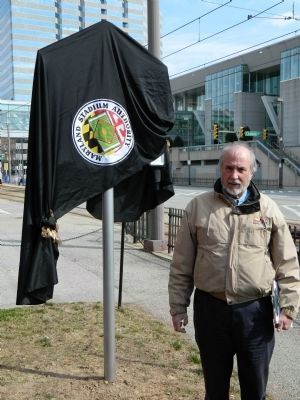
The Camden Yards Light Rail Station is dedicated to Richard H. “Dick” Trainor (1929—1997) for his outstanding public service and leadership in the construction of transportation and public facilities throughout the state of . . . — — Map (db m37539) HM
To look at Bentley Springs today it is difficult to imagine its past as a major destination from Baltimore along the Northern Central Railroad. This small village in upper Baltimore County is located just 4 miles below the Mason-Dixon line and 31 . . . — — Map (db m146982) HM
The first inhabitant of this village, dating back to 1706, was Richard Gist, father of the Revolutionary War hero, Mordecai Gist. The industrial development of the Jones Falls Turnpike Road, circa 1806, and later by the Baltimore and Susquehanna . . . — — Map (db m2272) HM
"Make easy the way for them and then see what an influx of articles will be poured upon us." - George Washington, 1786
You are standing on the original roadbed of the Baltimore & Ohio Railroad, North America's first common-carrier . . . — — Map (db m8874) HM
"There was a man killed yesterday by a fall from the centre of the 1st arch [of the Thomas Viaduct]... What a sympathy there is between these rough men. It was affecting to see his fellow laborers dressed in their best, going in a body to escort . . . — — Map (db m8872) HM
The reign of stagecoaches and Conestoga Wagons on the Baltimore and Frederick-Town Turnpike only lasted seventy years. Omnibuses, attached to teams of four horses, began rolling out from Baltimore to Catonsville in 1862.
The Catonsville Short . . . — — Map (db m5536) HM
"Any Monday morning one could hear the beginnings of the stir of activity as the heavy machinery in the mill started to move, gather speed and settle into a steady rhythmic rumble which was maintained at the same rate day and night . . . — — Map (db m8871) HM
For over 100 years, streetcars graced the streets of Baltimore and the heavily traveled #8 line to Catonsville was one of the most popular. This line swung north from Frederick Rd. and plunged into the woods for a brief run to its terminus at . . . — — Map (db m5534) HM
In June 1864, Confederate Gen. Robert E. Lee sent Gen .Jubal A. Early’s corps from the Richmond battlefields to the Shenandoah Valley to counter Union Gen. David Hunter’s army. After driving Hunter into West Virginia, Early . . . — — Map (db m201632) HM
Completed in 1832, the North Central Railroad carried passengers and freight between Baltimore, York, and Harrisburg for 140 years. After the decline of the railroad, the railroad bed was converted to a rail trail in 1984. Today the Maryland portion . . . — — Map (db m53200) HM
Phoenix, one of the many mill towns of the 1800s in Baltimore County, survives today as a secluded little village beside the Gunpowder River and the Northern Central Railroad 15 miles north of Baltimore. Today's Phoenix, with its big Victorian . . . — — Map (db m53202) HM
From the railroad track bed of Baltimore & Susquehanna Railroad, below Padonia Road bridge. Cut out area in block is to hold rail track. Cockeysville marble, found during construction of the Light Rail.
Historical Society of Baltimore . . . — — Map (db m137189) HM
Approximately 200 yards northwest of this spot an iron foundry, owned by William McShane, was built in 1894. When asked to give a name to the railroad depot serving his new foundry, he chose “Dundalk” in honor of the birthplace of his . . . — — Map (db m2126) HM
The #26 streetcar brought thousands of Baltimoreans to Bayshore Park. Trolleys provided a convenient way for people to travel and could be chartered for group outings. Many people spent their vacations trolleying, using trolley maps to see where . . . — — Map (db m49089) HM
Established 1772 by the three Ellicott brothers from Bucks County, Pennsylvania. They opened the road from here to Baltimore. The B. and O. R. R. was completed to this point May 20, 1830. — — Map (db m175) HM
Freeland, Maryland is the last of the small rural villages in Northern Baltimore County that flourished along the route of the Northern Central Railroad during the late 1800's and early 1900's. It is located just 1-1/2 miles south of the . . . — — Map (db m131332) HM
By 1860 the Western Maryland Railroad reached this site. In 1871 Dr. Charles A. Leas employed Augustus Bouldin, surveyor, to plan the town. The railroad and ideal climate encouraged the early development as a resort center with Victorian summer . . . — — Map (db m2067) HM
The Western Maryland Rail Road Station at Glyndon was built in 1895 of Baltimore County white marble with a red tile roof. Destroyed by fire on December 24, 1903, the building was replaced in 1904 with the present brick structure. On June 7, . . . — — Map (db m82281) HM
Glyndon's "pump house" dates to October 1915, when the Glyndon Volunteer Fire Company decided to dig a new well to meet the community's water needs. The Fire Company, located at the time at 41 Railroad Avenue and led by President C.H. Whittle . . . — — Map (db m176174) HM
On this site in 1830 a hotel with a waiting room and ticket office was built to serve passengers of the B & O Railroad. Here horses were changed for the final 5-mile trip to Ellicott Mills. Hence the name Relay House. As the B & O Railroad grew the . . . — — Map (db m103010) HM
Civil Engineer, graduated West Point 1822. Among engineer officers sent to assist railroad companies, surveyed first route of B&O, 1827. Resigned commission to pursue distinguished railroad career. Enlisted in Confederate Army after Baltimore riots, . . . — — Map (db m40864) HM
Tucked safely beneath the MTA Light Rail tracks sits a line of undisturbed marble track bed. This is one of the two oldest extant segments of the Baltimore & Susquehanna (B&S) Railroad Line, which stretched north from Baltimore into Pennsylvania's . . . — — Map (db m150004) HM
Mining operations a the Greenspring Quarry began in the mid 1800s, and the stone was used to build railroad beds for the transportation of supplies during the Civil War. In later years the mined materials were used for construction of the Baltimore . . . — — Map (db m131337) HM
Congratulations! You are helping to protect the environment. By choosing to ride the Light Rail instead of driving a car to your destination, you are conserving fuel, decreasing emissions, and reducing pollutants in the air and water.
Many . . . — — Map (db m8483) HM
The Trolley Trail runs on the track bed built for the #9 Route that connected Ellicott City to Catonsville and Baltimore. Many used the line to get to work or shop in Baltimore. "I could tell by the color whether to board the front or the . . . — — Map (db m144720) HM
The rock looming in this cut here on the #9 Trolley Trial was once liquid magma that squeezed into a fault between pieces of the Earth's crust, then cooled to form Ellicott City granite. In the mighty construction project of 1898, workers . . . — — Map (db m144722) HM
The first streetcar service to Overlea began on July 14, 1903. Overlea and many other Baltimore suburbs developed when streetcar lines were extended from downtown. These lines allowed workers to live away from the noise and crowds of the city and . . . — — Map (db m114579) HM
At some point in the mid 1700s, a farmer by the name of Parke laid off a portion of his farm into building lots. Thus the village of Parkton came into being. Two notable events helped Parkton become a major commerce center between Baltimore and . . . — — Map (db m240371) HM
The spot where you are standing was once one of the busiest centers for the Northern Central Railroad in the state of Maryland. There were two 90 railroad car sidings, two crossover switches, three locomotive sidings for repairs and storage, a wye . . . — — Map (db m152205) HM
Points of Interest
Monkton Train Station
The restored 1898 Monkton Train Station (located at 1820 Monkton Road, Monkton, MD 2111) serves as a museum, gift shop and Ranger Station. It's a great place to learn about the history of the . . . — — Map (db m240370) HM
Railroad History Notes
The trail's railroad past remains evident in many of the fixtures and markers along the trail today. Railroad enthusiasts will enjoy visiting the historic Monkton Train Station, now a park visitor center and railroad . . . — — Map (db m240372) HM
Early romantic suburb designed in 1889 by Frederick Law Olmsted, Sr., father of landscape architecture in America. On 204 acres of James Howard McHenry’s “Sudbrook” estate. Olmsted designed a naturalistic landscape with curvilinear roads . . . — — Map (db m2266) HM
Beginning in 1873, the picturesque Viaduct Station Hotel complimented the Thomas Viaduct. The Viaduct Hotel was built in the town of Relay as a rural vacation spot and a comfortable place for passangers to change trains. The hotel was a forerunner . . . — — Map (db m8833) HM
Before you stands the thomas Viaduct, named after Philip E. Thomas, the first president of the Baltimore & Ohio Railroad. This unique bridge has become an enduring symbol of the B&O Railroad and the Patapsco Valley, surviving several floods and . . . — — Map (db m8834) HM
Created in 1830 as a change point, or "relay," for horses hauling the first scheduled railroad cars in the U.S. The first rail link to nation's capital began here. Thomas Viaduct carries the track across Patapsco gorge; completed in 1835, it is the . . . — — Map (db m8764) HM
Front
Commenced, July 4th, 1833.
Finished, July 4th, 1835.
Rear
Johnathan Knight,
Chief Engineer
Caspar W. Wever,
Superintendent of Construction.
Designed by
Benjamin H. Latrobe. . . . — — Map (db m127) HM
In 1835, the Baltimore and Susquehanna Railroad constructed a track through Baltimore County which included a siding and switch near a large tract of land owned by the Sparks family. Railroad officials gave the name Sparks to the switch and soon . . . — — Map (db m95687) HM
Marble blocks from Cockeysville area quarries were used in 1836 to bed the track for this section of the Baltimore and Susquehanna, one of the nation's earliest commercial railroads. Revealed during construction of the MTA Light Rail, the marble . . . — — Map (db m150003) HM
Some of the finest Thoroughbred horses in the country lived in the stable to your left. Horses with names such as "Grey Medeley," "Post Boy" and "Tuckahoe" enhanced the reputation and purses of their owners. As founding members of the Baltimore . . . — — Map (db m144063) HM
Bald Eagles typically nest within a half-mile of water. The resident Bald Eagle's nest downstream from this viewing platform is in a forested area. It is important to stay a reasonable distance from Bald Eagle nests when observing. Human . . . — — Map (db m162783) HM
Ospreys build their nests on man-made structures such as the channel markers along the stream. They travel up Fishing Creek to hunt for fish, which make up 99 percent of the osprey's diet.
Only the male red-winged blackbird has a bright red . . . — — Map (db m162791) HM
Built by Otto Mears of Colorado in 1897. The train track linking Washington, D.C. to Chesapeake Beach crossed here. The original depot to the east is now the Railway Museum. Excursion steamboats also brought passengers to Chesapeake Beach from . . . — — Map (db m731) HM
From 1900 until 1935 the Chesapeake Beach Railway carried Washington excursionists through the honeysuckle-scented countryside of Southern Maryland, giving the railway the name of The Honeysuckle Line. The last train left Chesapeake Beach on . . . — — Map (db m162780) HM
This Property has Been Placed
on the
National Register
of
Historic Places
By the United States
Department of the Interior
This railroad station, erected in 1898-1899, is the original eastern terminus of the Chesapeake Beach Railway. . . . — — Map (db m109617) HM
Look and see if you can see any of these fish or reptiles swimming in the creek below.
Keep an eye out for turtles sunning sunning themselves on rocks and the banks of the creek.
• Red-eared sliders can live up to 30 years. They have . . . — — Map (db m181868) HM
The Chesapeake Beach Railway ran trains to Chesapeake Beach from 1900 until the bankruptcy of the Railway in 1935. After that time the East Washington Railway operated out of the maintenance yard and roundhouse at Seat Pleasant, Maryland. Between . . . — — Map (db m162781) HM
Here you can see the evidence of the railroad that used to bring visitors from Washington D.C. to Chesapeake Beach during the summertime. The Mears Avenue road bed is the same road bed as the Railroad. The Railroad went west along Fishing Creek . . . — — Map (db m162784) HM
Here you can see the evidence of the railroad that used to bring visitors here from Washington, D.C., to Chesapeake Beach during the summertime. The concrete path you have just walked along is the railroad bed. The railroad crossed Fishing Creek . . . — — Map (db m181862) HM
The grand Belvedere Hotel stood at this corner from 1900 until it burned in 1923. This was also the location of the southern end of the Boardwalk. A walkway from the Boardwalk to the shore joined 17th Street at the water's edge. From 1914 until the . . . — — Map (db m162777) HM
Near this spot in the early 20th century, steam trains from The Chesapeake Beach Railway discharged passengers from Washington DC. They arrived with great expectations for a busy day enjoying the many amusements of the beach and park. The park . . . — — Map (db m109665) HM
The tree canopy is ahead of you serves as a home to birds and other marsh dwelling animals. Some of the trees that you will see here and along with other parts of the trail includes: black locust, sweetgum, and black cherry trees. . . . — — Map (db m162788) HM
Clean watersheds are important to the ecology of the Chesapeake Bay. The local Fishing Creek watershed is somewhat small in size and serves as a nursery and breeding grounds for many species of wildlife. It is important that we keep the . . . — — Map (db m162794) HM
Switchgrass, a native plant species, has a growing season which occurs from late spring to early fall. During the colder months it becomes dormant. Switchgrass is abundant throughout the United States east of the Rocky Mountains, and into Canada. . . . — — Map (db m181864) HM
The Town of North Beach, Calvert County's northernmost municipality, was originally called "North Chesapeake Beach" when it was first developed for summer cottages in 1900. Before then, this view of the beach itself had changed relatively little . . . — — Map (db m138545) HM
The shores of the Chesapeake Bay are the perfect place to watch the ebb and flow of the tides. Just as with the tides, the small town of North Beach has experimented many changes in its history.
The town's original heyday began in the early . . . — — Map (db m138559) HM
There was a boardwalk in North Beach as early as the 1930's. The structure was only two blocks long, from 5th to 7th Street on Atlantic Avenue. It was destroyed by the hurricane of 1933. The boardwalk was rebuilt several times following storm . . . — — Map (db m138547) HM
The Town of North Beach was incorporated in 1910. It was developed and marketed as a waterfront resort by the North Beach Land and Improvement Company. In 1906, the company opened a road between Chesapeake Beach and what was then called North . . . — — Map (db m138548) HM
Gift: Gorman A. Buckler CMM74.521
Set of cast iron gears formerly used to operate the marine railway at M.M. Davis and Son shipyard on Mill Creek, Solomons, Maryland: The gears were originally powered by steam and later converted to electricity. A . . . — — Map (db m60231) HM
Sailboats and steamboats unloaded and loaded passengers and freight all along the Choptank. As trade increased in the 1800s, people built wharves and landings every few miles on the river.
A wharf bustled with activity when a boat arrived. . . . — — Map (db m68427) HM
It was in the teens when an select group of ladies formed a Community Club in Ridgely. Their goal was to improve the town's appearance. The bulk of the members consisted of the "wives of local merchants, cannery owners, and farmers." . . . — — Map (db m205477) HM
1867 - 1887
The railroad was completed to Ridgely in 1867. At that time there were two houses in the place — the Vernon property and the Ridgely Hotel. One of the factors getting the railroad to come. Mr. Thomas Bell had to give an area of . . . — — Map (db m205474) HM
In 1896, Ridgely emerged from a village into the dignity of a town. It was incorporated as such with the following first town commissioners: Mr. Sylvester Smith; Mr. T.W. Jones, Dr. F.P. Herr; Mr. T.L. Day; and Mr. J.T. Saulsbury.
The entire . . . — — Map (db m205470) HM
The Railroad was completed to Ridgely in 1867. The Saulsbury home was one of the earliest residences in Ridgely. Erected in 1867 by James K. Saulsbury, the building combined a large store where a widely known general merchandise business was . . . — — Map (db m205482) HM
The Ridgely Flag was designed by Yolanda Mayers in honor of the town's Sesquicentennial Celebration. The flag incorporates elements of Ridgely history. The town colors are a perfect backdrop for the "Dream City" banner and train number 513 in . . . — — Map (db m205483) HM
Around 1750, the community of Eldersburg was founded by John Elder, who was given a land grant from the King of England for as much land as Elder could stake out in 24 hours. John Elder staked an 800-acre farm named Perseverance on a stagecoach . . . — — Map (db m134037) HM
We hope you will enjoy our small town and the friendly atmosphere our community offers. We pride ourselves on Mt. Airy's small-town charm, first-rate businesses, family-friendly neighborhoods with excellent sports and other activities, stable . . . — — Map (db m199371) HM
Mount Airy was first settled along what is now Ridgeville Boulevard. With the construction of the Old National Pike (Route 40) in the 1730s, Ridgeville became a rest stop and overnight lodging for travelers on the road. In 1831 the Baltimore and . . . — — Map (db m199372) HM
In 1839, the Baltimore and Ohio Railroad extended its line through Mount Airy Cut, and a village soon developed here. During the Civil War, Co. K, 14th New Jersey Infantry, guarded the railroad and National Road at Mount Airy. Pine Grove Chapel, . . . — — Map (db m201590) HM
The Railway Express Agency was a national package delivery service created during World War I. It used the nation's railroads from 1918 to 1975 for the transportation and delivery of parcels, money and goods. The agency's red and green baggage carts . . . — — Map (db m199365) HM
From the late 1800s to the mid-1960s, Mount Airy was a busy farming community. The B&O Railroad carried commodities from Mount Airy to market, and carried needed manufactured goods into Mount Airy. A grain mill was always one of the centers of . . . — — Map (db m98472) HM
This building was originally constructed in 1957 on land owned by the B&O Railroad. It was built by Ira Watkins as the Lynn Shop, which sold ladies and children's clothes. Since then, this building has been home to:
This site was once the Mount Airy rail yard. Passenger trains stopped here to pick up and drop off passengers at the Mount Airy Station. Children from Watersville and other nearby communities would ride the train to attend school in Mount Airy. . . . — — Map (db m98471) HM
The Mount Airy Railroad Station was designed by the famed train and train station designer E. Francis Baldwin. It was built by the B&O Railroad, and served the railroad from 1875 until August 15, 1957. Afterwards, it provided space for a number . . . — — Map (db m98470) HM
One of many handsome structures designed by B&O architect E. Francis Baldwin, the station was built in 1884 along the Old Main Line. The building contained a ticket and telegraph office, separate waiting rooms for men and women, and a freight room. . . . — — Map (db m133983) HM
Near here the Confederate cavalry of Major General J.E.B. Stuart entered Carroll County from Cooksville about daybreak June 29, 1863. After damaging the tracks and bridge of the Baltimore and Ohio Railroad at Sykesville, they marched to Westminster . . . — — Map (db m133800) HM
The arrival of the Pennsylvania Railroad Company in 1871 placed the town's merchants and farmers in an advantageous economic situation. Edward Reindollar expanded a grain elevator by including a steam flour mill in 1892, while Edward Zepp set up . . . — — Map (db m80556) HM
Union Gen. John F. Reynolds was killed at Gettysburg on July 1, 1863 while directing his command along the Chambersburg Turnpike in the early fighting. His body was carried to a house in town. Orderlies searched for a coffin but found only a too . . . — — Map (db m201605) HM
During the Civil War, railroads for the first time attained strategic importance for transporting troops and equipment. On July 1, 1863, Gen. Herman Haupt, chief of U.S. Military Railroads, assumed control here of the Western Maryland Railroad to . . . — — Map (db m13828) HM
Home of George Milligan (1720–1783), Scotch trader. Purchased from his son, Robert, by Louis McLane (1784–1857) who represented Delaware in the United States House and Senate, was Minister to Great Britain, Secretary of the Treasury, . . . — — Map (db m144538) HM
One of the earliest in the United States, the line ran from New Castle on the Delaware River, crossed the highway here, and extended to Frenchtown on the Elk River 1½ miles west of this point. — — Map (db m1564) HM
In 1918, the United States purchased Perry Point as the proposed site for an ammonium nitrate plant to assist in the war effort. The federal government signed a contract with the Atlas Powder Company on February 1, 1918 to oversee construction . . . — — Map (db m184954) HM
On April 18-19, 1861, a week after the bombardment of Fort Sumter, South Carolina, Confederate sympathizers attacked U.S. Army forces en route to Washington in Baltimore, 35 miles southwest of here. On the second day shots were fired and soldiers . . . — — Map (db m145865) HM
In the early 1900's this site was the location of a large railroad freight yard with roundhouse. It was an important transportation hub, linking East-West rail lines with North-South lines. It was the largest business enterprise in the Town of . . . — — Map (db m184951) HM
The Naval Base, [then] known as “The Naval Proving Ground”, was established in the town of Indian Head in 1890. Its main purpose was to test guns, powder, fuses and other naval ordnances as well as producing smokeless powder. The Naval . . . — — Map (db m70905) HM
The Indian Head White Plains Railroad, which became the current rail trail, connected to an internal railroad system at the Indian Head Naval Proving Ground. The existing railroad system at Indian Head reflects four periods: of development: Naval . . . — — Map (db m98545) HM
Who would ever have imagined that a railroad track, once built with a focus on war, would one day be the source of such peace…
The Indian Head – White Plains Railroad was built during World War I in an effort to meet increased . . . — — Map (db m98546) HM
The Naval Base, known as The Naval Proving Ground, was established in the town of Indian Head in 1890. Its main purpose was to test guns, powder fuses and other naval ordnances as well as producing smokeless powder. The Naval Proving Ground played . . . — — Map (db m98544) HM
In June 1864, Union Lieutenant General Ulysses S. Grant was intent on destroying Confederate General Robert E. Lee's army at Petersburg, Virginia. Lee saw an opportunity to capture undefended Washington, D.C. He sent Lieutenant General Jubal A. . . . — — Map (db m213594) HM
Roads are a record of those who have gone before.
—Rebecca Solnit
Monocacy has always served as an important crossroads. Here, you'll travel along the same routes used by Civil War soldiers and . . . — — Map (db m213596) HM
First called Berlin, later Barry, and finally named Brunswick in 1890, the town's fortunes fluctuated with the times. The canal was built here in 1834 and a large gristmill, powered by canal water, was built on the canal across from the towpath. . . . — — Map (db m4333) HM
The area now known as Brunswick was prime for growth for over a century before the C&O Canal reached this location in 1834. Originally the site of a trading post and ferry, the water crossing here provided a route for settlers heading west into . . . — — Map (db m61864) HM
The Baltimore & Ohio Railroad
The Railroad… Past and Present
The railroad arrived in 1834, but its major impact on the town of Berlin (as it was then known) occurred fifty years later when the Baltimore & Ohio (B&O) . . . — — Map (db m103428) HM
By 1787, Leonard Smith laid out the town of Berlin in 96 lots, most of which were half acre in size. Geographic location made this locale a natural transportation crossroads. Settlers and merchants traveled to and through the new town to utilize . . . — — Map (db m103437) HM
This is the earliest known cemetery in the city of Brunswick. Historical records indicate burials here from 1799 or earlier. The oldest standing gravestone is marked "M.C. 1810." Most of the recorded burials took place between 1890 and 1910. The . . . — — Map (db m173616) HM
The Brunswick Railroad Museum and the Chesapeake and Ohio Canal National Historic Park Visitor Center exist side by side today, just as the transportation modes did when first arriving here in 1834. However, the early relationship between canal . . . — — Map (db m60881) HM
425 entries matched your criteria. Entries 101 through 200 are listed above. ⊲ Previous 100 — Next 100 ⊳