On Railroad Square near Maryland Avenue, on the right when traveling east.
(below the window) Preserve the memory of train crew by ringing this bell for Ricky, Jimmy and Jim.
(above the window) The bricks which make up the base of the bell memorial came from the B & O roundhouse that once stood in . . . — — Map (db m1981) HM
On Chesapeake and Ohio Canal Towpath, 0.2 miles west of South Maple Avenue, on the left when traveling west.
Things to Know Before You Go
The Brunswick TRACK Trail is 0.8 miles one way (1.6 miles round trip) from this kiosk to milepost 56. The trail follows the path of the original towpath of the Chesapeake and Ohio Canal. Along the . . . — — Map (db m197953) HM
Near South Seton Avenue (Business U.S. 15) 1.7 miles north of Catoctin Mountain Highway (U.S. 15), on the right when traveling north.
Bells pealed throughout Saint Joseph's Valley with the joyful news of Mother Seton's beatification March 17, 1963
The Academy Bell, cast by George Harley of Philadelphia (n.d.), summoned boarding and day pupils of Saint Joseph's Academy to . . . — — Map (db m147288) HM
On Urbana Pike (State Highway 355), on the right when traveling north.
On July 9, 1864, at 2:00 a.m., the last train of Union reinforcements pulled into Monocacy Junction just hours before the battle. The addition of 3,400 veterans increased Wallace's total to 6,600 men. While Wallace was successful in delaying the . . . — — Map (db m76713) HM
On B & O Avenue at South East Street, on the right when traveling west on B & O Avenue.
(North Facing Side): The Lower Depot Neighborhood The railroad transformed 19th century America, facilitating long-distance travel and the efficient transfer of raw materials to factories and agricultural and manufactured goods to markets. . . . — — Map (db m2823) HM
Near Dwight D. Eisenhower Highway (Interstate 70) south of Baltimore National Pike (U.S. 40), on the right when traveling east.
Crisscrossed By Transportation Routes, Home To America's Earliest Industries, And Meeting Place For National Leaders, Maryland's Appalachian Region Has Been Pivotal In The Growth Of The Country
Throughout its history, the nation has . . . — — Map (db m116529) HM
On an autumn day in 1898, an electric railway car rolled into Myersville changing the way of life here and connecting the town with Middletown, Frederick and eventually Hagerstown.
The Myersville and Catoctin Railway was built and paid for by . . . — — Map (db m107931) HM
This Building Served As The Last H & F
Trolley Station To Serve This Community
H & F Trolley Service To Myersville
Extended From 1898 To 1945. — — Map (db m107611) HM
On Canal Street, on the right when traveling west.
This [railroad] company was met by the most decided and inveterate opposition, on the part of the Chesapeake and Ohio Canal Company. Philip E. Thomas, President, Baltimore and Ohio Railroad Company The proximity of railroad tracks by the . . . — — Map (db m7661) HM
Completed in 1837, Lockhouse 28 stands where fierce competition between the C&O Canal and the B&O Railroad brought both to a standstill. Both sides fought long and hard in the race to reach the Ohio River valley and control mid-Atlantic western . . . — — Map (db m100779) HM
On Clay Street (Maryland Route 28) east of Catoctin Mountain Highway (U.S. 15).
In mid-June 1863, with rumors of a pending reinvasion of Maryland by Confederate forces, most Baltimore and Ohio trains stopped running past here. As tension mounted, the New York Times reported that no trains were departing Baltimore, “except . . . — — Map (db m743) HM
On Clay Street (Maryland Route 28) east of Catoctin Mountain Road (U.S. 15).
The rail line immediately before you served as an important means of supply and communication during the Civil War (the station, and tracks to Washington, D.C., on the southern or right side of the station were built later). Here at Point of Rocks, . . . — — Map (db m744) HM
In 1832, Point of Rocks served as the western terminus for the C&O Canal and the B&O Railroad. This was not deliberate, but the result of competition as the transportation pioneers wrangled in court for rights to the narrow passage between the . . . — — Map (db m59743) HM
On Monroe Street at Clay Street (Maryland Route 28), on the right when traveling south on Monroe Street.
The "Point of Rocks" has long served as a distinguishing landmark along the Potomac River. Native Americans, and later colonial settlers and traders, used the vicinity as a home and transportation corridor. River transportation and improvements . . . — — Map (db m168024) HM
On Clay Street (Maryland Route 28) east of Monroe Street, on the right when traveling east.
The Chesapeake & Ohio Canal was an ambitious project to provide access from the east coast into the rapidly developing western areas of the United States. Construction on the C&O Canal began July 4, 1828. It originated in Georgetown (Washington, . . . — — Map (db m168027) HM
On Commerce Street at Clay Street (Maryland Route 28), on the right when traveling north on Commerce Street.
The B&O rail line served as an important means of supply and communication during the Civil War (the station and tracks to Washington, D.C., on the southern or right side of the station were built later).
At Point of Rocks, the Baltimore & . . . — — Map (db m168030) HM
On Commerce Street, 0.1 miles east of Monroe Street, on the right when traveling east.
The arrival of the B&O Railroad in Point of Rocks would have a major impact on the future development of the town. The first train arrived on April 23, 1832, and Point of Rocks remained the terminus of the Old Main Line for three years. Continued . . . — — Map (db m168032) HM
On Catoctin Furnace Road (Maryland Route 806) 0.1 miles north of Catoctin Hollow Road, on the left when traveling north.
"a large blast furnace— the stack wheel and bellows and all the buildings… are built in the best manner"
— From a notice in the Frederick Town Herald advertising the sale of the furnace property in 1871 workers employed or . . . — — Map (db m184182) HM
On East Main Street (Route 550) west of Alley 5, on the left when traveling east.
The Western Maryland Railroad first reached Thurmont (then Mechanicstown) in 1871 and stopped in our town until 1967 when the depot (shown in upper left corner of mural) was closed and demolished.
The H&F Railway (trolley system) traveled . . . — — Map (db m131817) HM
On Hotel Road east of Deer Park Hotel Road, on the left when traveling east.
President Grover Cleveland and his bride, the former Frances Folsom, arrived here the day following their White House wedding on June 2, 1886. They spent their honeymoon at this Deer Park Hotel cottage. — — Map (db m470) HM
On Maryland Highway (Maryland Route 135) west of Deer Park Hotel Road, on the right when traveling east.
The hotel was built by the Baltimore and Ohio Railroad, opened July 4, 1873, and operated until 1829. Dismantled 1942. President and Mrs. Grover Cleveland spent their honeymoon at the cottage in June, 1886. — — Map (db m472) HM
On Hotel Drive south of Hotel Road, on the right when traveling south.
Built by the B&O Railroad, opened July 4, 1873 and operated until 1929. Razed 1942. This was one of the most exclusive mountain resorts in the east. Many nationally prominent people, including four United States Presidents, were guests here. — — Map (db m5413) HM
On Maple Street at Walnut Street, on the right when traveling east on Maple Street.
Drawn by the rich forest timberlands of Garrett County, John W. McCullough arrived in the Friendsville area in the 1890's and figured prominently in the expansion of the town. He constructed several sawmills in the area and in 1894 built a 36 inch . . . — — Map (db m134372) HM
On Morris Avenue north of Oak Street, on the left when traveling north.
With the arrival of the train to Friendsville in 1889, the Yough Manor Lumber Co. extended the tracks upriver two miles to service a sawmill. A. Knabb and company had already set up a stave mill for barrels in 1891 and the town's name became Krug, . . . — — Map (db m134370) HM
On Chestnut Street at 1st Avenue, on the left when traveling north on Chestnut Street.
The Confluence and Oakland Railroad (C&O) was completed between Confluence, PA and Friendsville. Upon completion, it was leased to the B&O Railroad for 99 years. In Confluence it connected with the B&O Baltimore, Pittsburgh and Chicago Railways. . . . — — Map (db m134353) HM
On West 1st Avenue west of Paull Street (Maryland Route 560), on the right when traveling west.
Absolutely crucial to the success of the unique town of Mountain Lake Park was without question its B&O Railroad station, the point at which hundreds of summer residents and visitors, after departing the extreme head and humidity of . . . — — Map (db m235198) HM
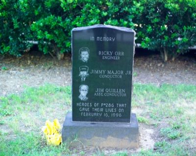
On East First Avenue just east of Paull Street (Maryland Route 560), on the left when traveling east.
Janet Deem • Nancy Deem • Merle Harvey • Nancy Harvey • Richard Hinkle • Lee Hoffman • Shirley Lee
Dedicated to the memory of the precious children who lost their lives at this railroad crossing, in one of the nation's worst school . . . — — Map (db m235203) HM
On G Street south of Maryland Highway (Maryland Route 135), on the left when traveling south.
No long farewell embraces,
No time to say goodbye,
You were gone before we knew it.
And no matter how we try,
Our tears can’t build a stairway,
Nor our memories a lane,
That reaches up to Heaven,
To bring you home again.
So with . . . — — Map (db m480) HM
On East Liberty Street west of South 2nd Street, on the left when traveling west.
Given the architectural design term "Queen Ann Style" by its architect E. Francis Baldwin, the Baltimore and Ohio Railroad's "1884 Oakland Train Station" is the third building to occupy this location. The first station was a small, square two-story . . . — — Map (db m399) HM
On E Liberty Street at s 1st Street, on the right when traveling south on E Liberty Street.
This 1920 locomotive was originally built by the Baldwin Locomotive works for the Jonesboro, Lake City and Eastern Railroad in Mississippi. The locomotive originally carried the number 40, but was changed to #76 in 1925, when it was leased to the . . . — — Map (db m135601) HM
On East Liberty Street west of South Second Street, on the left when traveling west.
This 1920 locomotive was originally built by the Baldwin Locomotive
Works for the Jonesboro, Lake City and Eastern Railroad in Arkansas.
The locomotive originally carried the number 40, but was changed to
#76 in 1925, when it was leased to the . . . — — Map (db m199475) HM
Near East Liberty Street at South 1st Street, on the right when traveling east.
This 1955 B&O Railroad Caboose was donated to the Town of Oakland by the B&O Railroad Museum, Baltimore, Md. In 2013/2014 it was fully restored, inside and out, by Alexander Jacob Savopoulos, a member of Boy Scout Troop #22, as his Eagle Scout . . . — — Map (db m153142) HM
On Herrington Manor Road east of Fingerboard Road.
On April 26, 1863, during the Confederate occupation of Oakland, a detachment of Confederate Capt. John H. McNeill's partisan rangers attacked the Baltimore and Ohio Railroad bridge here over the Youghiogheny River. They were part of a larger group . . . — — Map (db m481) HM
On West Liberty Street near South 2nd Street, on the left when traveling west.
Directly behind you, John W. Garrett built Garrett Memorial Church in 1869 as a memorial to his brother Henry S. Garrett who died in 1867. The site was originally chosen by his brother for a church, but he died before steps could be taken to build . . . — — Map (db m467) HM
On East Green Street west of South 3rd Street (U.S. 219), on the left when traveling west.
Oakland's Main Street Maryland program and its Design Committee spent several years looking for a way to beautify the town's barren walls while informing its residents and visitors about town history. A review of other small towns around the . . . — — Map (db m234244) HM
On East Liberty Street west of South 2nd Street, on the left when traveling west.
On Sunday, April 26, 1863, a detachment of Confederate Capt. John H. McNeill's partisan rangers under Col. A. W. Harman attacked the Baltimore and Ohio Railroad facilities here in Oakland. They were part of Confederate Gen. William E. “Grumble” . . . — — Map (db m485) HM
On East Liberty Street west of South 2nd Street, on the left when traveling west.
On April 20, 1863, Confederate Gens. William E. "Grumble" Jones and John D. Imboden began a raid from Virginia through present-day West Virginia on the Baltimore & Ohio Railroad. Taking separate routes, they later reported that they . . . — — Map (db m235130) HM
On West Liberty Street just west of West Liberty Street, on the left when traveling west.
In many ways the Town of Oakland owes its early development as one of Garrett County's largest towns and as the county seat to the arrival of the Baltimore and Ohio Railroad. In 1851 the railroad meandered through the Youghiogheny Glades on its way . . . — — Map (db m153147) HM
Near East Liberty Street, 0.1 miles north of North 2nd Street, on the left when traveling north.
When the Oakland B&O Museum was established in 2013 the organizers hoped some day to acquire an authentic steam locomotive for display in front of the 1884 Oakland Train Station. This dream came to fruition in 2017/2018, beginning with a surprise . . . — — Map (db m153139) HM
In the late 1800's there were twelve passenger trains a day stopping at the Oakland train station, and hordes of vacationers flooding the town. Perhaps the busiest section of Oakland was Railroad Street, which ran parallel to the tracks between . . . — — Map (db m167585) HM
On Alder Street at Second Street, on the right when traveling west on Alder Street.
On this site in 1851 stood the blacksmith shop operated by Henry August Rasche, then in the employ of the Baltimore and Ohio Railroad. The B & O line was at the time being extended through Oakland, Allegany County, Maryland, westward into Preston . . . — — Map (db m68878) HM
On West Liberty Street near South 2nd Street, on the left when traveling west.
Facing the railroad tracks directly in front of you was the Glades Hotel. Deriving its name from the nearby area called “Youghiogheny Glades,” the Glades Hotel was built in the mid-1850’s by Perry Lyle directly across the tracks from . . . — — Map (db m468) HM
Early in the 1870's, the Baltimore and Ohio Railroad realized an asset to its passenger train service would be having a resort hotel in this area. First, it built the Deer Park Hotel in 1873, which proved so successful that in 1875 they started . . . — — Map (db m68876) HM
On East Liberty Street near South 2nd Street, on the left when traveling west.
Dailey’s Park. The Garrett County Historical Society welcomes you to Dailey’s Park. This park is named in honor of John and Ann Rebecca Dailey, who owned and operated the Glades Hotel in Oakland from 1859 to 1881. Historian Thomas Scharf noted . . . — — Map (db m466) HM
On Maryland Highway (Maryland Route 135) west of Altamont Road, on the left when traveling east.
On April 26, 1863, a detachment of Confederate Capt. John H. McNeill’s partisan rangers attacked the Baltimore and Ohio Railroad facilities here at Altamont. They were part of a larger group that entered Oakland that Sunday as Confederate Gen. . . . — — Map (db m37544) HM
Near North Parke Street at Diamond Street (later Centennial Lane).
Some 100 or 150 years ago, the watchman was protected from the weather by the shed that sat at the post road crossing of the north/southeast coast Washington to New York Highway, later known as route 7. When the crossing was closed the small . . . — — Map (db m146848) HM
On East Bel Air Ave at Post Road, on the left when traveling east on East Bel Air Ave.
At intersection of Old Post Road (established 1666) and Bush Neck Road (1670) were a tavern and relay point for stagecoaches in 18th Century. In 1835 nearby stop on Philadelphia, Wilmington and Baltimore Railroad was named for Aberdeen, Scotland, . . . — — Map (db m1258) HM
Commemorating the local history of the Maryland and Pennsylvania Railroad that traveled along this path connecting with the Spenceola CanneryCommissioned by The Harford County Cultural Arts BoardFunded through "Public Art Project Grant" Maryland . . . — — Map (db m96734) HM
On Tollgate Road at County Home Road on Tollgate Road.
In 1994, Harford County Department of Parks & Recreation helped to found the MA & PA Heritage Trail, Inc. to revitalize the former Maryland & Pennsylvania Railroad into a pedestrian greenway that will ultimately stretch from Fallston to Forest Hill. — — Map (db m96741) HM
On Williams Street at W. Ellendale Street on Williams Street.
The History of the MA & PA Trail
The MA & PA Railroad stretched between Baltimore at North Avenue & Howard Streets, on to Towson, through Long Green Valley into Harford County. It ended at Market Street in York, Pennsylvania. Even by the . . . — — Map (db m104553) HM
On County Home Road at Tollgate Road on County Home Road.
At the very spot where you're standing, Harford County's past and present converge in an exciting way! The Ma and Pa Railroad, which is short for Maryland and Pennsylvania Railroad, was at one time an integral part of Harford County's . . . — — Map (db m97824) HM
Post card image of the Bel Air station circa 1907.
The 77.2 mile route of the Ma & Pa ran from Baltimore to York. While significantly longer than other railroads, the Ma & Pa passed through the center of Harford County. This is the . . . — — Map (db m173926) HM
On North Avenue at Running Creek Way, on the right when traveling west on North Avenue.
The original name of the Ma & Pa was the narrow gauge Maryland Central Railroad that reached Bel Air in 1883. After merging with the York and Peach Bottom Railway in 1891, its name became the Baltimore and Leheigh Railroad. This meandering . . . — — Map (db m238311) HM
On E. Jarrettsville Road, on the right when traveling east.
Railroad service came to Forest Hill circa 1883, when the Maryland Central Railroad laid narrow gauge track from Baltimore to Delta, PA. The MCR suffered financial difficulties and emerged as the Maryland Central Railway Company in 1888. Interested . . . — — Map (db m187768) HM
Prior to roads and rails, water was the most significant transportation mode in the growth of our nation's emerging economy. Situated at the juncture of the Susquehanna River and the Chesapeake Bay, the town of Havre de Grace grew and prospered. . . . — — Map (db m163126) HM
Beginning in 1838,the cars of the Philadelphia, Wilmington & Baltimore Railroad were carried across the Susquehanna River by the first railroad ferry in the U.S. A rail bridge replaced the ferry in 1866. The surviving granite piers carried the . . . — — Map (db m79601) HM
On Stafford Road, on the right when traveling north.
The appearance of the area around the mouth of Deer Creek was changed by the construction of the Susquehanna and Tidewater Canal. A 246'-long dam, consisting of a heavy timber frame filled with rocks and covered with planking, raised the level of . . . — — Map (db m213919) HM
On Mountain Road (Maryland Route 152) at Old Joppa Road, on the right when traveling east on Mountain Road. Reported missing.
On July 10, 1864, Major Harry Gilmor’s Confederate cavalry camped in this building (an old stage coach headquarters) on his way to burn the Pennsylvania R. R. bridge across the Gunpowder, where he captured General W. B. Franklin. — — Map (db m196723) HM
On Torrey C. Brown Rail Trail at Wiseburg Road, on the right when traveling south on Torrey C. Brown Rail Trail.
As railroads developed in the mid-nineteenth century there was a need to control the traffic on the railroads.
The first attempt to control traffic was by the use of the telegraph system. Station Masters would have the normal printed . . . — — Map (db m183575) HM
On Wiseburg Road, 0.1 miles east of White Hall Road, on the right when traveling east.
Railroad History Notes
The trail's railroad past remains evident in many of the fixtures and markers along the trail today. Railroad enthusiasts will enjoy visiting the historic Monkton Train Station, now a park visitor center and railroad . . . — — Map (db m183576) HM
On Wiseburg Road just north of School House Road, on the right when traveling south.
After passing through the village of Monkton, the Northern Central Railroad continued northward through the abandoned villages of Pleasant Valley and Bluemount toward White Hall, a distance of approximately 3.5 miles.
Early in the 1800s a . . . — — Map (db m183579) HM
On Dorsey Run Road at Junction Drive, on the left when traveling south on Dorsey Run Road.
Began service in 1840 between Annapolis and the Washington Branch of the Baltimore & Ohio Railroad at Annapolis Junction. Sponsored by the state, the line was a key route for travel to and from the capital. During the Civil War it was used by Union . . . — — Map (db m80024) HM
Near Old Guilford Road, 0 miles south of Guilford Road when traveling south.
Granite was quarried in the Guilford area beginning in the 1830s and continuing until 1925 - a span of almost a century. As the nearby cities of Baltimore and Washington expanded, there was a need for quality building stone for structures and . . . — — Map (db m20501) HM
[picture of steam locomotive] Steam locomotive. A small saddle-tanker locomotive pushed and pulled freight cars around in the quarry, and hauled heavy loads of granite to the main line of the railroad. The saddle-tanker had a water tank that . . . — — Map (db m20499) HM
History: Railroad expansion in the 19th century required strong, dependable bridges to carry trains over ravines and rivers. Early bridges were built of stone that was sturdy but expensive. Timber bridges often had to be replaced as wood . . . — — Map (db m20498) HM
On Furnace Avenue, 0.1 miles west of Railroad Avenue, on the left when traveling south. Reported permanently removed.
On May 5, 1861, U.S. Gen. Benjamin F. Butler occupied Relay, Maryland, with the 8th New York and 6th Massachusetts Infantry Regiments and Cook's Boston Battery of light artillery. Their mission was to prevent Confederate sympathizers from . . . — — Map (db m5876) HM
On Furnace Avenue, 0.1 miles east of Railroad Avenue, on the left when traveling east.
On May 5, 1861, the 8th New York and 6th Massachusetts Infantry Regiments and Cook's Boston Battery of light artillery occupied the heights around you. Their mission was to prevent Confederate sympathizers from sabotaging the strategic Thomas . . . — — Map (db m150570) HM
On Furnace Avenue at Riverwatch Avenue, on the right when traveling north on Furnace Avenue.
Elkridge During the Nineteenth Century
The nineteenth century began with economic decline before years of rapid growth and prosperity transformed Elkridge. During the eighteenth century, the Patapsco River served as the economic lifeblood of . . . — — Map (db m150571) HM
On Main Street (Maryland Route 144) at Maryland Avenue, on the right when traveling east on Main Street. Reported permanently removed.
One of the first railroads in the country, constructed in 1830 of wooden rails that carried horse-drawn cars, extended from Baltimore to Ellicott's Mills. This station was built the next year, and soon steel rails replaced wooden ones as the . . . — — Map (db m29961) HM
On Main Street (Maryland Route 144) at Maryland Avenue, on the right when traveling east on Main Street.
When the Civil War began, the Baltimore & Ohio Railroad became a vital transportation route for the Federal armies, with men and supplies passing by this station day and night. To protect the line, local businessman Thomas McGowan raised the . . . — — Map (db m144727) HM
During the Civil War, Union troops stationed here guarded the viaduct against destruction by southern forces. The viaduct stands today as originally built, 612 feet long, 28 feet wide, and curving in a graceful four degree arc across the Patapsco. . . . — — Map (db m73577) HM
Near Maryland Avenue. Reported permanently removed.
The Baltimore & Ohio (B&O) Railroad's Ellicott City complex was the heart and soul of a bustling industrial and agricultural community once known as Ellicott’s Mills. The railroad built several structures on or near the site, including Oliver . . . — — Map (db m112255) HM
Near Maryland Avenue at Main Street (Maryland Route 144). Reported permanently removed.
Ellicott City’s Main Street is the National Pike, part of the road system that moved Americans west. Only two decades after the road was constructed, a new transportation rival appeared. In 1831, America’s first railroad, the Baltimore & Ohio, . . . — — Map (db m720) HM
On Main Street just east of Maryland Avenue, on the right when traveling east.
Ellicott City’s Main Street is the National Pike, part of the road system that moved Americans west. Only two decades after the road was constructed, a new transportation rival appeared. In 1831, America’s first railroad, the Baltimore & Ohio, . . . — — Map (db m243568) HM
Near Maryland Avenue just south of Main Street (Maryland Route 144), on the left when traveling south.
Designed by noted architect E. Francis Baldwin and constructed in 1885, the Freight House served as a loading platform and storage room for freight. Materials were transferred in and out of the building on Maryland Avenue using a wooden platform. . . . — — Map (db m144728) HM
The single set of tracks outside the museum’s fence was the original right-of-way of the Baltimore & Ohio (B&O) Railroad. Now owned by CSX Transportation, this right-of-way has been in continuous use since 1830. For many years there were two sets . . . — — Map (db m112291) HM
On Maryland Avenue just south of Main Street (Maryland Route 144), on the left when traveling south.
The single set of tracks outside the museum's fence was the original right-of-way for the Baltimore & Ohio (B&O) Railroad. Now owned by CSX Transportation, this right-of-way has been in continuous use since 1830. A second set of tracks was added in . . . — — Map (db m144726) HM
On Foundry Street near Gorman Road, on the left when traveling north.
Spanning the Little Patuxent River is the sole surviving example of the bridging system invented, 1850, by Wendel Bollman, Baltimore engineer. It was the first system, entirely of iron, used by the Baltimore and Ohio railroad and the first in . . . — — Map (db m123610) HM
Near Foundry Street north of Gorman Road when traveling west.
The mill town of Savage served a vital need for the United States Army after the Civil War began in 1861. William Baldwin who had purchased the mills in 1859 manufactured canvas for cannon covers and tents. Although cotton was in short supply, . . . — — Map (db m22462) HM
On Washington Boulevard (U.S. 1) 0.2 miles north of Waterloo Road (Maryland Route 175), on the right when traveling north.
In 1771 William Spurrier opened a tavern at the intersection of the main routes linking Baltimore, Washington and Annapolis, now US 1 and MD 175. As traffic increased, it served as the first horse changing station for stages southbound from . . . — — Map (db m3237) HM
After the Civil War, America's cities created new transportation systems that enabled them to prosper and grow. During this time, major rail lines were built to connect Washington, D.C. with other cities. Smaller electric streetcar or 'trolley' . . . — — Map (db m116775) HM
On Capital Crescent Trail, 1.9 miles south of River Road (Route 190), on the left when traveling south.
In 1991, John Dugger saw the potential for the abandoned B&O rail line, from Georgetown to Silver Spring, to become a multi-use trail for greater Washington, DC. Together with Henri Barholomot, John secured funds for the Intermodal Surface . . . — — Map (db m245542) HM
On Capital Crescent Trail, 0.1 miles north of River Road (Maryland Route 190), on the left.
Neal Potter
Neal Potter was a model public citizen, an economist, and a lifelong advocate for world peace, human rights, and responsible government. As a Montgomery County citizen and Councilmember and Montgomery County Executive, he . . . — — Map (db m182165) HM
Near Old Georgetown Road (Maryland Route 187) just east of Arlington Road, on the right when traveling east.
In 1890, the Tennallytown and Rockville Railroad ran along Old Georgetown Road to Bethesda Park, a favorite amusement spot in the area. The park entrance was located on the corner of what is now Old Georgetown Road and Sonoma Road. — — Map (db m73284) HM
On Capital Crescent Trail, 1.7 miles south of River Road (Maryland Route 190), on the right when traveling south.
In the nineteenth century, boats along the Chesapeake and Ohio Canal transported coal from Cumberland, Maryland to Georgetown in the District of Columbia. By the early twentieth century, trains had replaced boats as a means of transportation and . . . — — Map (db m185532) HM
Near Bethesda Avenue at Woodmont Avenue, on the right when traveling east.
The Capital Crescent Trail follows the route of an old railroad line called the Georgetown Branch of the Baltimore and Ohio (B&O). It's all that remains of an unrealized attempt by the B&O to construct a major rail link between the . . . — — Map (db m83) HM
Near Capital Crescent Trail, 1.9 miles south of River Road (Maryland Route 190), on the left when traveling south.
The Capital Crescent Trail follows the route of an old railroad line called the Georgetown Branch of the Baltimore and Ohio (B&O). It's all that remains of an unrealized attempt by the B&O to construct a major rail link between the . . . — — Map (db m185530) HM
Near River Road (Maryland Route 190) west of Willard Avenue, on the right when traveling west.
From 1891 to 1900, the Glen Echo Railroad Company, later known as the Washington and Glen Echo Railroad, operated a trolley line through what is now Willard Avenue Park. This line comprised part of a series of interconnecting systems that provided . . . — — Map (db m126644) HM
Near Darnestown Road (Route 28) just east of Seneca Road (Route 112), on the left when traveling east.
Darnestown Road is one of the oldest roads in Montgomery County. Once an old trail, the route dates back to 1600 when it was used by the Seneca Indians. Native Americans Established villages, planted maize, and fished along the Potomac Palisades. . . . — — Map (db m69645) HM
On Beallsville Road (State Highway 109) just south of Hillrise Lane, on the right when traveling south.
Built about 1930 as the first metering station for the Washington area gas supply, this building was saved from imminent destruction by concerned citizens dedicated to both the preservation of the visible past and revitalization of the railroad. . . . — — Map (db m139683) HM
On South Summit Avenue south of East Diamond Avenue, on the left when traveling south.
The Gaithersburg Railroad Station and freight house were built in 1884 as handsome replacements for the adjacent small frame structure which served as a freight depot when the Metropolitan Branch of the B & O Railroad was extended to Gaithersburg . . . — — Map (db m1039) HM
Near South Summit Avenue just south of East Diamond Avenue, on the right when traveling north.
Gaithersburg began as an agricultural community. With the coming of the railroad in the late 1800's, markets in Washington, D. C. and Baltimore were opened to area farmers. Wheat, vegetables, fruits, meats, dairy products, and cider could be easily . . . — — Map (db m128821) HM
Near South Summit Avenue just south of East Diamond Avenue, on the right when traveling north.
Before the arrival of the first European settlers, the area that is now the City of Gaithersburg was a land of dense forests and gently rolling hills. Frederick Avenue was a well-traveled path for the Piscataway and Tuscarora Indians, who hunted the . . . — — Map (db m3346) HM
On Olde Towne Avenue close to Fulks Corner Avenue, on the right when traveling west.
You are standing on the historic site of The Gaithersburg Wye, situated on 2.25 acres adjacent to the Metropolitan Branch of the old Baltimore and Ohio Railroad. This railroad is currently known as the CSX.
The Gaithersburg Wye . . . — — Map (db m141319) HM
In 1989, this passenger waiting room was taken down from its location in Landover, MD., and brought to this site and re-assembled by the Montgomery County Conservation Corps. On behalf of the citizens of Garrett Park, the Mayor and Town Council . . . — — Map (db m219) HM
425 entries matched your criteria. Entries 201 through 300 are listed above. ⊲ Previous 100 — Next 100 ⊳