After filtering for Missouri, 325 entries match your criteria. The first 100 are listed. ⊳
Railroads & Streetcars Topic
By Michael E Sanchez, Jr., March 24, 2017
The Cyclone Marker back
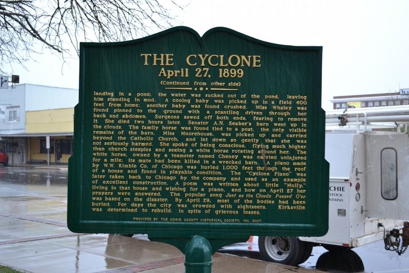
| 1 ► Missouri, Adair County, Kirksville — The Cyclone — April 27, 1899 — |
| On North Elson Street just north of West Washington Street, on the left when traveling south. | |||
| 2 ► Missouri, Boone County, Columbia — Commerce — Flat Branch Park — |
| On South 4th Street at Cherry Street, on the right when traveling south on South 4th Street. | |||
| 3 ► Missouri, Boone County, Columbia — Missouri, Kansas & Texas Railroad Depot — |
| On South 4th Street at East Broadway, on the right when traveling north on South 4th Street. | |||
| 4 ► Missouri, Boone County, Columbia — Missouri-Kansas-Texas Railroad Yard — Downtown Columbia, MO — |
| On South 4th Street at Cherry Street, on the right when traveling south on South 4th Street. | |||
| 5 ► Missouri, Boone County, Columbia — Transportation — Flat Branch Park — |
| On South 4th Street at Cherry Street, on the right when traveling south on South 4th Street. | |||
| 6 ► Missouri, Boone County, Rocheport — Edward D. "Ted" and Pat Jones — |
| 7 ► Missouri, Boone County, Rocheport — Katy Trail State Park 20th Anniversary — 1990 - 2010 — |
| 8 ► Missouri, Buchanan County, St. Joseph — C. B. & Q. 5614 Steam Locomotive — |
| On 10th Street near Seneca Street, on the left when traveling north. | |||
| 9 ► Missouri, Buchanan County, St. Joseph — Patee Town — |
| On Penn Street at South 10th Street, on the left when traveling east on Penn Street. | |||
| 10 ► Missouri, Buchanan County, St. Joseph — Transcontinental Telegraph — Electrical Engineering Milestone — |
| On Penn Street near 12th Street, on the right when traveling east. | |||
| 11 ► Missouri, Caldwell County, Hamilton — Hamilton Train Depot — |
| On Davis Street (State Highway 13) at McGaughy Street, on the left when traveling south on Davis Street. | |||
| 12 ► Missouri, Caldwell County, Kingston — Kingston — |
| On East Main Street just east of North Washington Street (Missouri Highway 13). | |||
| 13 ► Missouri, Callaway County, Jefferson City — History of Jefferson City Area — |
| Near Katy Road, 0.9 miles north of Oilwell Road, on the right when traveling north. | |||
| 14 ► Missouri, Callaway County, Jefferson City — Katy Trail State Park — |
| On Katy Road, 0.9 miles north of Oilwell Road, on the right when traveling north. | |||
| 15 ► Missouri, Callaway County, Jefferson City — N. Jefferson to Hartsburg — Points of Interest — |
| On Katy Road, 0.9 miles north of Oilwell Road, on the right when traveling north. | |||
| 16 ► Missouri, Callaway County, Jefferson City — N. Jefferson to Tebbetts — Points of Interest |
| On Katy Road, 0.9 miles north of Oilwell Road, on the right when traveling north. Reported damaged. | |||
| 17 ► Missouri, Cape Girardeau County, Cape Girardeau — 1875 — River Commerce — |
| On North Water Street at Themis Street, on the left when traveling south on North Water Street. | |||
| 18 ► Missouri, Cape Girardeau County, Cape Girardeau — 1880 — The Coming of The Railroad — |
| On North Water Street at Themis Street, on the left when traveling south on North Water Street. | |||
| 19 ► Missouri, Cape Girardeau County, Cape Girardeau — Cape Girardeau and the Railroad — |
| Near Aquasmi Street, on the right when traveling south. | |||
| 20 ► Missouri, Cass County, Harrisonville — Cass County — |
| On East Wall Street, on the left when traveling east. | |||
| 21 ► Missouri, Cass County, Harrisonville — United We Stand Divided We Fall — |
| 22 ► Missouri, Cass County, Pleasant Hill — 105 First Street — Historic Building 1881 — |
| On 1st Street south of Wyoming Street, on the right when traveling north. | |||
| 23 ► Missouri, Cass County, Pleasant Hill — 117 First Street — Historic Building circa 1895 — |
| On 1st Street north of Commercial Street, on the right when traveling north. | |||
| 24 ► Missouri, Cass County, Pleasant Hill — Missouri Pacific Railroad Depot — Historic Building circa 1903 — |
| On Boardman Street south of Paul Street / Wyoming Street, on the right when traveling south. | |||
| 25 ► Missouri, Cass County, Pleasant Hill — Pleasant Hill, Missouri — |
| On Veterans Parkway (AKA Lake Street) at Paul Street, on the right when traveling south on Veterans Parkway (AKA Lake Street). | |||
| 26 ► Missouri, Clark County, Athens — Businesses in Athens, circa 1853-1860 — |
| Near County Road 81 (County Highway 81) at County Highway CC, on the right when traveling west. | |||
| 27 ► Missouri, Clay County, Liberty — Interurban Railroad - Withers Station — [Westboro-Canterbury Greenway Trail] — |
| On South Withers Road, 0.1 miles south of Owens Drive, on the right when traveling south. | |||
| 28 ► Missouri, Clay County, Liberty — Interurban Railway Bridge — [Westboro-Canterbury Greenway Trail] — |
| Near Park Lane south of Broadmore Lane, on the right when traveling south. | |||
| 29 ► Missouri, Clay County, Liberty — Kansas City to Liberty to Excelsior Springs Interurban Depot — |
| On Mill Street (Missouri Route H) at Leonard Street (Missouri Route 33), on the right when traveling east on Mill Street. | |||
| 30 ► Missouri, Clay County, Liberty — Scales and Rails — |
| On Water Street north of Mill Street, on the left when traveling north. | |||
| 31 ► Missouri, Clinton County, Cameron — Abraham Lincoln / John Wilkes Booth — |
| On North Walnut Street (Business Interstate 35) at East 2nd Street, on the left when traveling south on North Walnut Street. | |||
| 32 ► Missouri, Clinton County, Cameron — Cameron Railroads — |
| On U.S. 69 north of 1st Street, on the right when traveling north. | |||
| 33 ► Missouri, Clinton County, Cameron — Herbert Clark Hoover — 1874 - 1964 — 31st President of the United States — |
| On North Cherry Street north of West 3rd Street, on the right when traveling north. | |||
| 34 ► Missouri, Clinton County, Cameron — John T. Walker — Rock Island Lines — 1852 • 1922 — |
| On Cherry Street at 3rd Street, on the right when traveling south on Cherry Street. | |||
| 35 ► Missouri, Clinton County, Cameron — Rutherford B. Hayes / William T. Sherman — |
| On Park Avenue, 0.4 miles west of South Chestnut Street, on the right when traveling north. | |||
| 36 ► Missouri, Clinton County, Plattsburg — Clinton County — |
| On North Main Street south of East Maple Street, on the right when traveling north. | |||
| 37 ► Missouri, Cole County, Jefferson City — The Missouri River Valley as a Transportation Corridor — |
| On Jefferson Street at Capitol Avenue, on the left when traveling north on Jefferson Street. | |||
| 38 ► Missouri, Cooper County, Boonville — "Caboose #134" — A Tribute to the Katy Railroad — |
| On 1st Street north of Spring Street, on the right when traveling north. | |||
| 39 ► Missouri, Cooper County, Boonville — 25th Anniversary — Katy Trail State Park — 1990-2015 — |
| Near 1st Street near Spring Street. | |||
| 40 ► Missouri, Cooper County, Boonville — Boonville Depot |
| On 1st Street north of Spring Street, on the right when traveling north. Reported unreadable. | |||
| 41 ► Missouri, Cooper County, Boonville — Boonville to New Franklin — Points of Interest — |
| Near West Spring Street at 1st Street. | |||
| 42 ► Missouri, Cooper County, Boonville — Boonville to Pilot Grove — Points of Interest — |
| Near West Spring Street at 1st Street. | |||
| 43 ► Missouri, Cooper County, Boonville — History of Boonville — |
| On West Spring Street. | |||
| 44 ► Missouri, Cooper County, Boonville — The End of the Line |
| On 1st Street north of Spring Street, on the right when traveling north. Reported unreadable. | |||
| 45 ► Missouri, Cooper County, Pilot Grove — Early Travel Route — |
| On 2nd Street at Roe Street, on the right when traveling east on 2nd Street. | |||
| 46 ► Missouri, Cooper County, Pilot Grove — History of Pilot Grove — |
| On 2nd Street at Roe Street, on the right when traveling east on 2nd Street. | |||
| 47 ► Missouri, Cooper County, Pilot Grove — Pilot Grove - 1873 — |
| On Roe Street at College Street (Missouri Route 135), on the right when traveling west on Roe Street. | |||
| 48 ► Missouri, Cooper County, Pilot Grove — Pilot Grove to Boonville — Points of Interest — |
| On 1st Street at Roe Street (Missouri Route M), on the left when traveling east on 1st Street. | |||
| 49 ► Missouri, Cooper County, Pilot Grove — Pilot Grove to Clifton City — Points of Interest — |
| On 1st Street at Roe Street (Missouri Route M), on the left when traveling east on 1st Street. | |||
| 50 ► Missouri, Crawford County, Cuba — Confederates in Cuba — |
| On Buchanan Street just south of West Washington Street (Missouri Highway ZZ), on the right when traveling south. | |||
| 51 ► Missouri, Crawford County, Cuba — St Louis, Salem & Little Rock Railroad — |
| On North Franklin Street (State Highway 19) at Washington Street (State Highway ZZ) on North Franklin Street. | |||
| 52 ► Missouri, DeKalb County, Maysville — DeKalb County — |
| On Main Street (Missouri Route 6) at Polk Street (Missouri Highway A), on the right when traveling west on Main Street. | |||
| 53 ► Missouri, Franklin County, Gerald — Gerald Depot — Rock Island — Built 1909, Relocated 1986 — |
| Near West Fitzgerald Avenue (U.S. 50) west of West 6th Street, on the left when traveling west. | |||
| 54 ► Missouri, Franklin County, New Haven — Miller's Landing — New Haven — Lewis and Clark National Historic Trail — |
| Near Main Street west of Miller Street, on the right when traveling west. | |||
| 55 ► Missouri, Franklin County, New Haven — New Haven — 1856 - 1956 — |
| On Main Street at Miller Street, on the left when traveling east on Main Street. | |||
| 56 ► Missouri, Franklin County, New Haven — The Iron Horse Arrives — New Haven — Lewis and Clark National Historic Trail — |
| On Main Street west of Cottonwood Street, on the left when traveling east. | |||
| 57 ► Missouri, Franklin County, Pacific — War on the Pacific Railroad — |
| On South 1st Street north of Orleans street. | |||
| 58 ► Missouri, Franklin County, Washington — 1865 Missouri Pacific Railroad Depot — Freight Depot — |
| On West Front Street east of Cedar Street, on the right when traveling west. | |||
| 59 ► Missouri, Franklin County, Washington — 2 — Missouri Pacific Passenger Depot — 1924 — |
| On West Front Street at Elm Street, on the right when traveling west on West Front Street. | |||
| 60 ► Missouri, Franklin County, Washington — Missouri Pacific Railway Station — 1923 — |
| On West Front Street east of Cedar Street, on the right when traveling west. | |||
| 61 ► Missouri, Franklin County, Washington — 4 — Pacific House — 1855 — |
| On West Front Street near Elm Street, on the right when traveling east. | |||
| 62 ► Missouri, Franklin County, Washington — 1 — Pacific Railroad Depot — 1865 — |
| On West Front Street at Cedar Street, on the right when traveling west on West Front Street. | |||
| 63 ► Missouri, Franklin County, Washington — Washington's Railroad History — Railroad Heritage Park — |
| On West Front Street east of Cedar Street, on the right when traveling west. | |||
| 64 ► Missouri, Gasconade County, Hermann — The Caboose Museum — |
| On East 1st Street (State Highway 100) just east of Gutenberg Street, on the right when traveling west. | |||
| 65 ► Missouri, Gasconade County, Owensville — Railroad Crossing — |
| On East Mcfadden Avenue just west of North 1st Street, on the right when traveling west. | |||
| 66 ► Missouri, Gentry County, Albany — Gentry County — |
| On U.S. 136/169 at State Route H, on the right when traveling east on U.S. 136/169. | |||
| 67 ► Missouri, Greene County, Springfield, Commercial Street Historic District — First Springfield Railroad — |
| On East Commercial Street west of North Washington Avenue, on the right when traveling west. | |||
| 68 ► Missouri, Greene County, Springfield, Downtown Springfield — 21 — History of Springfield Public Square — Now Park Central Square — 1835-1970 — |
| Near Park Central Square west of E St. Louis Street. | |||
| 69 ► Missouri, Grundy County, Trenton — Trenton — |
| On Main Street (State Highway 6) just north of East 7th Street, on the right when traveling north. | |||
| 70 ► Missouri, Henry County, Clinton — Henry County — |
| On Washington Street at Franklin Street, on the left when traveling south on Washington Street. | |||
| 71 ► Missouri, Holt County, Oregon — Holt County — |
| On West Nodaway Street (Missouri Route 111) just east of South Washington Street, on the right when traveling east. | |||
| 72 ► Missouri, Howard County, Glasgow, Chariton Township — History of Glasgow — |
| On 1st Street (State Highway 5/240) at Market Street, on the left when traveling north on 1st Street. | |||
| 73 ► Missouri, Howard County, Glasgow, Chariton Township — Worlds First Large All-Steel Bridge — |
| On Water Street at Market Street, on the right when traveling south on Water Street. | |||
| 74 ► Missouri, Howard County, New Franklin — Franklin and New Franklin — |
| On Broadway, in the median. | |||
| 75 ► Missouri, Howard County, New Franklin — KATY Caboose #127 — |
| On Broadway at Missouri Street (Missouri Route 5), on the right when traveling east on Broadway. | |||
| 76 ► Missouri, Howard County, New Franklin — Missouri - Kansas - Texas Railroad — |
| On Broadway, in the median. | |||
| 77 ► Missouri, Howard County, New Franklin — The New Franklin Viaduct — |
| On Missouri Street (Missouri Route 5) at Katy Trail State Park, on the left when traveling south on Missouri Street. | |||
| 78 ► Missouri, Iron County, Arcadia — The Arcadia Valley — Battle of Pilot Knob — |
| On State Highway 72 at Thompson Road, on the left when traveling west on State Highway 72. | |||
| 79 ► Missouri, Iron County, Ironton — War In The Arcadia Valley — Missouri's Civil War — |
| On S. Main Street at W. Russell Street, on the left when traveling north on S. Main Street. | |||
| 80 ► Missouri, Iron County, Pilot Knob — Railroad Depot — Battle of Pilot Knob — |
| On Bogy Street at Walnut Street, on the right when traveling north on Bogy Street. | |||
| 81 ► Missouri, Iron County, Pilot Knob — The Arcadia Valley — Battle of Pilot Knob — |
| On N. McCune Street, 0.2 miles north of Cedar Street, on the left when traveling north. | |||
| 82 ► Missouri, Jackson County, Independence — The Railroad Comes to Town! — Santa Fe, Oregon, and California National Historic Trails — |
| On West College Street at North McCoy Street, on the left when traveling east on West College Street. | |||
| 83 ► Missouri, Jackson County, Kansas City, Central Hyde Park — Eagle Scout Tribute Fountain — |
| On 39th Street at Gillham Road and Harrison Parkway, on the left when traveling east on 39th Street. | |||
| 84 ► Missouri, Jackson County, Kansas City, Central Hyde Park — Hyde Park Neighborhood — Architect: George A. Mathews (1860-1903) Constructed: 1897-1917 — 1897 National and Kansas City Landmark Janssen Place Historic District — |
| Near East 36th Street at Janssen Place, on the right when traveling east. | |||
| 85 ► Missouri, Jackson County, Kansas City, Countryside — Country Club Line Historical Trolley Station — |
| On 54th Street at Brookside Boulevard, on the right when traveling east on 54th Street. | |||
| 86 ► Missouri, Jackson County, Kansas City, Countryside — James G. Ashley, Jr. and Pamela C. Ashley — |
| On Brookside Boulevard at 55th Street, on the right when traveling north on Brookside Boulevard. | |||
| 87 ► Missouri, Jackson County, Kansas City, Downtown Kansas City — Darby Trotter Spirit Mall — Riverfront Heritage Trail — |
| On West 8th Street at Madison Avenue, on the right when traveling west on West 8th Street. | |||
| 88 ► Missouri, Jackson County, Kansas City, Downtown Kansas City — Frontier Railroads in Kansas City — |
| On West 8th Street at Madison Avenue, on the right when traveling west on West 8th Street. | |||
| 89 ► Missouri, Jackson County, Kansas City, Downtown Kansas City — Moving Settlers West — |
| Near Riverfront Trail. | |||
| 90 ► Missouri, Jackson County, Kansas City, Downtown Kansas City — The Chicago, Milwaukee and St. Paul Railroad — |
| Near West 22nd Street west of Baltimore Avenue. | |||
| 91 ► Missouri, Jackson County, Kansas City, Downtown Kansas City — The Chicago, Milwaukee and St. Paul Railroad Freight House — 101-123 W. 22nd Street, Kansas City, Missouri — |
| Near West 22nd Street west of Baltimore Avenue. | |||
| 92 ► Missouri, Jackson County, Kansas City, Downtown Kansas City — Union Station Kansas City — |
| On West Pershing Road at Main Street, on the right when traveling west on West Pershing Road. | |||
| 93 ► Missouri, Jackson County, Kansas City, Downtown Kansas City — Union Station's Lamp Post Clock — |
| On OK Street west of Main Street, on the left when traveling west. | |||
| 94 ► Missouri, Jackson County, Kansas City, Oakwood — Where People Once Lived — |
| On Hickman Mills Drive south of Marion Park Drive, on the left when traveling south. | |||
| 95 ► Missouri, Jackson County, Kansas City, Old Westport — Three Trails West — |
| On Broadway Boulevard at Westport Road, in the median on Broadway Boulevard. | |||
| 96 ► Missouri, Jackson County, Kansas City, River Market — Hannibal Bridge — |
| Near Main Street. | |||
| 97 ► Missouri, Jackson County, Lee's Summit — William B. Howard Station Park — |
| On SE Main Street north of SE 3rd Street, on the left when traveling north. | |||
| 98 ► Missouri, Jasper County, Carthage — Carthage — |
| On Esterly Drive, 0.2 miles west of Missouri Route 96, on the right when traveling east. | |||
| 99 ► Missouri, Jasper County, Webb City — Prosperity Junction Station and Street Car #60 — Historic Landmarks — |
| Near Tracy Street near Main Street. | |||
| 100 ► Missouri, Jasper County, Webb City — Southwest Missouri Electric Railway Company — 1889 - 1939 — |
| Near Tracy Street near Main Street. | |||
325 entries matched your criteria. The first 100 are listed above. Next 100 ⊳