On N Street south of East 2nd Street, on the left when traveling south.
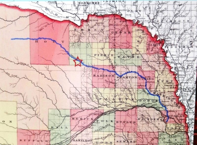
A Route and a Power Source: The Elkhorn Valley The Elkhorn Valley was a natural travel corridor into north-central and western Nebraska. Water, wood, and grass provided people and animals the critical resources to move overland wagons. Travel . . . — — Map (db m159076) HM
On Box Butte Avenue just south of West 18th Street, on the right when traveling south.
By the mid-1880s the Sandhills had become an important cattle-raising region. The extension of the Burlington and Missouri Railroad westward through the Sandhills in 1877-1888 made ranching more profitable by making more accessible eastern markets. . . . — — Map (db m178801) HM
On North Main Street, 0.1 miles south of East 3rd Street, on the left when traveling south.
Like many Nebraska communities, Long Pine's history is tied to railroad development. When the Fremont, Elkhorn, and Missouri Valley line arrived in 1881, Long Pine became a bustling railroad town. The Chicago & North Western Railroad (CNW) built a . . . — — Map (db m182061) HM
On Windmill St Recreation Road east of Lowell Road (Nebraska Route 10C), on the right when traveling east.
Gibbon, on the old Mormon Trail, was the site of a unique experiment in homestead colonization. Originally conceived as a financial venture by Colonel John Thorp of Ohio, the Soldier's Free Homestead Colony was responsible for bringing the first . . . — — Map (db m79880) HM
Baldwin Built engine 481 in 1903. The original number was 1902, but was later renumbered 841 in 1915. It was used on the main line branch lines of the Union Pacific Railroad in Kansas until the winter of 1954-55, when it was brought to Kearney . . . — — Map (db m45428) HM
On Central Avenue at 19th Street, on the left when traveling north on Central Avenue.
Long before early French explorers named it the Platte River, or "flat waters," this heartland oasis was a crossroads. Migratory birds, abundant wildlife and Native Americans had been in residence for centuries when the confluence of the Oregon and . . . — — Map (db m58888) HM
On U.S. 30, 0.2 miles east of 46th Avenue, on the right when traveling east.
In the late 1880's, Kearney business leaders envisioned the city as a major manufacturing center. The Kearney Cotton Mill was among the many enterprises launched as part of this venture, which included paper, woolen, and oatmeal mills; plow and . . . — — Map (db m101852) HM
This depot was built in 1898 next to the Union Pacific tracks in Shelton. It was moved to this site in September 1975 and was the first building on the grounds of the Trails and Rails Museum of the Buffalo County Historical Society. It was donated . . . — — Map (db m45471) HM
On State Highway 2, 1 mile east of Ravenna Road (State Highway 68), on the right when traveling east.
The ill-fated Pleasanton Nebraska branch extended southwestward along the South Loup Valley from Boelus to Pleasanton, a distance of 22.42 miles. Construction from Boelus to Nantasket was completed in 1887 and reached Pleasanton in 1890. The line . . . — — Map (db m181793) HM
On State Highway 61, 0.2 miles north of Survey Valley Road, on the left when traveling north.
This natural valley extending east and west across the Sandhills became known as Survey Valley after the Burlington and Missouri River Railroad surveyed a prospective line from O’Neill to Alliance in 1887. No rails were ever laid. On January 19, . . . — — Map (db m178711) HM
On Front Street at Elm Street, on the left when traveling west on Front Street.
Potter began as a small Union Pacific Railroad settlement and depot midway between Kimball and Sidney. The station house was built by Union Pacific in 1870 and, as the only building in the settlement, also served as the post office and school. Its . . . — — Map (db m231144) HM
Near Interstate 80 (at milepost 61), 1.3 miles east of Upland Parkway (Alternate Interstate 80), on the right when traveling west.
Cheyenne County was organized in 1870 from lands ceded by the Cheyenne, Arapaho, and Dakota Sioux Indians. In the panhandle of Nebraska, it is part of the Cheyenne tableland portion of the Great Plains. Some fifteen miles west of Sidney lies the . . . — — Map (db m231054) HM
Near Interstate 80 (at milepost 61), 1.3 miles east of Upland Parkway (Alternate Interstate 80), on the right when traveling west.
In 1867 an Army tent camp was established near here to provide protection for Union Pacific Railroad construction crews. Three years later it became Fort Sidney, the nucleus for the town of Sidney, county seat of Cheyenne County. The rush to the . . . — — Map (db m231061) HM
On Lincoln Highway (U.S. 30) 1 mile west of 13th Avenue, on the left when traveling west.
Gold was discovered in the Black Hills in August, 1874. By the spring of 1876, the Army had stopped enforcing a treaty which reserved the hills for the Sioux Indians. Miners soon began to pour into the gold regions. From 1875 to 1881, the . . . — — Map (db m231079) HM
On East Smith Avenue (State Highway 21A Spur) just east of North Dorr Street, on the right when traveling east.
Anselmo began as a railroad town along the Burlington and Missouri River Railroad. The Burlington needed a stop for water, coal, and switching facilities. It built a depot, and the town itself was platted in November 1886. A Lincoln Land Company . . . — — Map (db m223426) HM
On South E Street (State Highway 2) at South 8th Avenue, on the left when traveling east on South E Street.
Broken Bow was platted 1882 by Jesse Gandy. He donated lots to people who would build a house or establish a business. He did this to influence voters to make the new town the Custer County seat, which they did in an election that fall. The . . . — — Map (db m180947) HM
On East 4th Street at Dakota Avenue on East 4th Street.
Designer: J.A.L. Waddell
Built By: Phoenix Bridge Company - Fabricator and Erector
Sooysmith & Company - Foundations & Piers
The stone of this monument came from piers of the previous bridge erected at this spot. The Pacific Short Line . . . — — Map (db m178597) HM
On McPhearson Street (U.S. 20) at State Highway 2, on the right when traveling east on McPhearson Street.
Crawford sprang up as a tent city on land owned by homesteader/newspaper correspondent William E. Annin in 1886 when the Fremont, Elkhorn and Missouri Valley Railroad pushed through the Nebraska Panhandle. To Incorporate the town, editor William . . . — — Map (db m44254) HM
Near Bridges to Buttes Byway (U.S. 20) south of Soldier Creek Road, on the right when traveling east.
On January 20, 1885. Congress granted the
Fremont, Elkhorn and Missouri Valley Railroad
a right-of-way through the Fort Robinson Military
Reservation. Later this line was acquired by the
Chicago and North Western. With direct rail access
in . . . — — Map (db m223433) HM
On Interstate 80 at milepost 227, on the right when traveling west.
Here in Dawson County, much of the early history is concerned with the pioneer trails to the west. The Mormon Trail to Utah and the first transcontinental railroad passed through here on the north side of the Platte River; the Oregon Trail and the . . . — — Map (db m228354) HM
On U.S. 30 at North Meridian Avenue, on the right when traveling east on U.S. 30.
The 100th longitudinal line west of Greenwich was the major goal set by Congress in building the first transcontinental railroad.
Construction of the Union Pacific track reached the Meridian on October 5, 1866.
To celebrate this record-breaking . . . — — Map (db m123869) HM
On U.S. 30, 0.1 miles west of Road 430, on the right when traveling east.
Here, on August 7, 1867, a band of Southern Cheyennes, led by Chief Turkey Leg, wrecked a west-bound Union Pacific freight train and handcar which preceded it.
The engineer and fireman were killed and the boxcars looted and burned.
One of the . . . — — Map (db m120893) HM
On U.S. 30 at Road 446, on the right when traveling east on U.S. 30.
Railroads played an important role in the settlement of the Great Plains. Their construction was particularly damaging to the Indian way of life, since railroads helped the military to patrol rapidly along their lines, and villages and farming . . . — — Map (db m101854) HM
Near Interstate 80 at milepost 100, on the right when traveling east.
The history of Big Springs, northeast of here, has been closely associated with the Union Pacific Railroad since 1867, when a station was established at that point. A nearby spring, from which the station derived its name, provided an . . . — — Map (db m68069) HM
On Interstate 80 at milepost 99, on the right when traveling east.
Julesburg, Colorado, visible to the southwest, was
established as a road ranche, trading post, and stage
station in 1859. Located near the junction of several
overland routes, Old Julesburg became an important
transportation and military . . . — — Map (db m228355) HM
On State Highway 25A at County Route 165, on the right when traveling north on State Highway 25A.
Here is the valley of Lodgepole Creek through which passed historic trails, telegraph lines, and railroads. The famed Pony Express followed the valley in 1860-61. "Nine Mile" Pony Express station was located just southeast of present Chappell; "Pole . . . — — Map (db m223445) HM
On West 3rd Street (State Highway 26E) just east of North Nebraska Street, on the right when traveling west.
Ponca, one of northeast Nebraska’s earliest communities, was platted in 1856 by Frank West and laid out by Dr. Solomon B. Stough. The town was named for the Ponca Indian tribe that inhabited the area when the first white settlers arrived. The . . . — — Map (db m206794) HM
On Main Street near 5th Avenue, on the right when traveling south.
The Union Pacific reached Fremont in 1866. The new Union Depot was erected at a cost of $50,000 and gave the approach to the city a dignified and completed appearance, with its winding gravel walks, grass and flower plots and wide frontage.
As a . . . — — Map (db m58553) HM
On South 10th Street, on the right when traveling east.
Omaha Union Station has been designated a National Historic Landmark designed by Gilbert Stanley Underwood for the Union Pacific Railroad. Omaha Union Station is an exceptional and highly complete example of Art Deco architecture. It is one of . . . — — Map (db m245195) HM
On Underwood Avenue at Happy Hollow Boulevard, on the left when traveling west on Underwood Avenue.
Dundee, Omaha's first suburb, was connected to downtown by the streetcar. Dundee was literally the end-of-the-line. The streetcars reversed their course just west of this site. In 1891, a steam driven "trolley" and then a horse-drawn car brought . . . — — Map (db m58356) HM
On 10th Street near Cuming Street, on the right when traveling south.
You are standing at the site of the original Union Pacific Omaha Shops.
From this point a railroad was begun that would fulfill a national destiny.
Even before Union Pacific was an American icon, it was an American dream. It was a . . . — — Map (db m58038) HM
Born in Virginia in 1824, James Megeath was the eldest of 10 children. By age 20, he had become a cattle and sheep trader. Struck by gold fever, he went to Calaveras County, California, in 1851, operating a general merchantise store for three . . . — — Map (db m58234) HM
On 10th Street near Leavenworth Street, on the left when traveling south.
No other improvement...can
equal in utility the railroad.
Abraham Lincoln
March 9, 1832
Dedicated by the railways of Omaha
to the service, comfort and
convenience of the people — — Map (db m35264) HM
On Farnam Street, on the right when traveling west.
The initial "B" identifies this as the headquarters for the Burlington and Missouri River Railroad, which occupied the upper floors upon completion in 1879 of the original building designed by A.R. Dufrene. Nave, McCord & Brady, wholesale grocers, . . . — — Map (db m229143) HM
On Jackson Street at 10th Street, on the left when traveling east on Jackson Street.
The Windsor Hotel, designed in the Italianate style, was constructed in two phases – the east wing was completed in 1885, and an addition to the west was finished by 1887. It was designed to be a workingman’s hotel, and with the proximity to . . . — — Map (db m35254) HM
On South Exeter Avenue at West Tecumseh Street, on the left when traveling north on South Exeter Avenue.
The first settler in Exeter Township, Fillmore County was Warren Woodard, who built the first house in 1870. The Burlington and Missouri River Railroad, building westward, determined Exeter's location in 1871. The town was laid out by the railroad . . . — — Map (db m78010) HM
On G Street at North 9th Street, on the right when traveling east on G Street.
The first homesteads were filed in 1866 by William O. Bussard and William C. Whitaker along the West Fork of the Blue River. Mrs. E. A. Whitaker, the first white woman, came in 1867. The first white children, Emma Whitaker Hall and Arthur Dixon . . . — — Map (db m206666) HM
On 2nd Street near Court Street (U.S. 136), on the left when traveling north.
Dedicated to the Citizens of Beatrice
for all their efforts put forth in the
Beatrice Centennial Celebrations of 2007
Beatrice, Nebraska Territory
Founded on this site July 4, 1857
Time Capsule to be opened on July 4, 2057
200 . . . — — Map (db m47616) HM
On Court Street (U.S. 136) at 2nd Street, on the right when traveling west on Court Street.
Railroads played a key role in the development of the Heritage Highway corridor. Trains brought settlers and goods west to the new towns and took farm products back to market. As times have changed and transportation has evolved, many railroad . . . — — Map (db m47620) HM
You are standing on an old road trace, lined with cottonwood trees, where freight was hauled by wagon. The ability to get goods to market is yet another reason Daniel Freeman homesteaded here, four miles from the town of Beatrice.
Freight roads . . . — — Map (db m47584) HM
On H Street, 0.2 miles east of 13th Avenue (State Highway 96), on the left when traveling east.
Burwell began as a post office named The Forks in 1875. The town was incorporated as a village and changed its name to Burwell in 1884. Three years later, the newly-incorporated Lincoln & Black Hills Railroad laid track from Central City to . . . — — Map (db m179191) HM
Near Railroad Street just east of North Main Street, on the left when traveling east.
The Early Years 1875-1881 Welcome to Atkinson — a city of 1,462 as of 2019 census and thank you for visiting Railroad Park. The Railroad played an important role in establishing our city. This picnic pavilion is on the west end of . . . — — Map (db m191594) HM
Near Railroad Street just east of North Main Street, on the left when traveling east.
Atkinson celebrated its Diamond Anniversary in August 1940 and The Atkinson Graphic newspaper published numerous articles describing meetings of various local clubs which were organizing activities leading up to the late summer event. In the June . . . — — Map (db m191595) HM
On Northwest 1st Street west of North Cleveland Avenue, on the left when traveling west.
The Grand Island and Wyoming Central branch of the Burlington railroad came through this area in 1887 and built a siding here named Mullen after a railroad contractor. In 1888 Trefren and Gandy platted the village of Mullen. Hooker County, named . . . — — Map (db m178920) HM
On Southwest 1st Street (State Highway 2) 10 miles west of North Washington Avenue (State Highway 97), on the right when traveling west.
When the Burlington & Missouri River Railroad (now the Burlington Northern-Santa Fe) reached this point in 1887, it built a siding named Hecla after a volcano in Iceland. A post office was established the same year, and construction of stockyards . . . — — Map (db m180869) HM
On River Road, 4 miles north of U.S. 136, on the right when traveling north.
The availability of suitable building material was of great importance to Nebraska’s pioneer settlers. Here in Jefferson County, native limestone was used for building and the stone was burned in kilns to produce lime for mortar and whitewash. The . . . — — Map (db m177301) HM
Near West Main Street (State Highway 49A Spur) just west of South Third Street, on the left when traveling west.
This region was once home to Oto and Missouri Indians, who ceded their land to the government before Nebraska Territory was created in 1854. White settlers arrived in 1857 and founded a town and post office named Helena about four miles west of . . . — — Map (db m177292) HM
On Broadway at 4th Street, on the right when traveling east on Broadway.
Tecumseh, the county seat of Johnson County, was incorporated in 1856. It was first called Frances in honor of the wife of Colonel Richard M. Johnson, for whom the county is named. In 1857 the town was renamed for the famous Shawnee Indian chief, . . . — — Map (db m48209) HM
On Harold Warp Memorial Drive (32nd Road) (State Highway 10) near State Highway 50A, on the right when traveling south.
The Burlington & Missouri River Railroad entered Nebraska at Plattsmouth in 1870 and built west to join the Union Pacific at Kearney Junction (now Kearney city) on September 3, 1872. The railroad bridge into Kearney was used for 104 years. It . . . — — Map (db m58980) HM
When the Union Pacific laid track west from Omaha in 1865 the rails also followed the Great Platte River Road. The Union Pacific linked up with the Central Pacific at Promontory, Utah in 1869 to complete the nation’s first transcontinental railroad. . . . — — Map (db m50788) HM
On North 7th Street at P Street, on the right when traveling south on North 7th Street.
The Burlington and Missouri River Railroad entered
Lincoln in 1870 - the first line to serve the young capital
city, established just three years earlier. Seven other
railroads followed in the next thirty years. Trade expanded
as the . . . — — Map (db m211301) HM
Near North Buffalo Bill Avenue, 0.8 miles north of Lincoln Highway (U.S. 30), on the right when traveling north.
After the completion of the Transcontinental Railroad in 1869, settlers began to establish farms and ranches all around the railroad line and they needed access to the railroad to ship their crops and cattle to market and travel to neighboring . . . — — Map (db m191900) HM
Near North Buffalo Bill Avenue, 0.8 miles north of Lincoln Highway (U.S. 30), on the right when traveling north.
This cabin was built in 1866 by R. E. Rowland out of native cedar found in the hills south of the Platte River. As a freighter to the town of Cottonwood Springs, near Maxwell, Nebraska, Rowland needed living quarters while staying in the area. . . . — — Map (db m242017) HM
Near North Buffalo Bill Avenue, 0.8 miles north of Lincoln Highway (U.S. 30), on the right when traveling north.
This log, two-story, cedar log structure was built in 1868 or 1869 by Mr. E.E. Ericsson. Each log is shaped and interlocked with the next with a minimal use of square nails. Mr. Ericsson was born in Varmland, Sweden on July 1st, 1835. He arrived . . . — — Map (db m191768) HM
Near North Buffalo Bill Avenue, 0.8 miles north of Lincoln Highway (U.S. 30), on the right when traveling north.
This is the boyhood home of William "Bill" M. Jeffers, president of the Union Pacific Railroad from 1937-1946. Remarkably he began his career as a janitor & call boy. As president, he prepared the railroad for the coming war and was appointed by . . . — — Map (db m191890) HM
On East Third Street at North Dewey Street, on the right when traveling east on East Third Street.
Sioux Lookout, the highest point in Lincoln County, was a prominent landmark on the overland trails.
From its lofty summit the development of the West unfolded before the eyes of the Sioux and other Indians.
Trappers and traders came by here . . . — — Map (db m107393) HM
Near North Buffalo Bill Avenue, 0.8 miles north of Lincoln Highway (U.S. 30), on the right when traveling north.
100-CA-7 class cabooses were built in Union Pacific shops in Omaha, Nebraska in 1959, numbered 25400 thru 25499. This caboose was updated in 1975 with federally approved toilets, axle-driven alternators, and other items necessary for system-wide . . . — — Map (db m191899) HM
Near North Buffalo Bill Avenue, 0.8 miles north of Lincoln Highway (U.S. 30), on the right when traveling north.
This shield is from the North Platte, NE. Union Pacific Depot 3-20-1918 to 11-1-1973 Home of WWII Canteen 12-25-1941 to 4-1-1946 — — Map (db m191939) HM
On Main Avenue east of 4th Street, on the right when traveling east.
Near here at a point midway between the source of the Elkhorn River and its entry into the Platte, is the town of Meadow Grove. The Elkhorn Valley has long been an important passageway for travelers and settlers. In 1739, the Mallet brothers made . . . — — Map (db m182088) HM
On Main Street (State Highway 88) at Gold Rush Byway (U.S. 385), on the right when traveling north on Main Street.
Old Oregon Trail, 1750 feet south, 1850-1869.
The Old Pony Express Route 6 mi south, 1860-1861.
The First Transcontinental Telegraph Line
passed 6 miles south, 1861-1870.
Old Deadwood Trail, 4 mi. west, 1874-1886.
Old Mormon Road, 1 mi. . . . — — Map (db m182056) HM
On Main Street just west of South 2nd Street, on the left when traveling west.
On August 29, 1854, shortly after the Kansas-Nebraska Act had opened the territory west of the Missouri River to permanent settlement, Richard Brown arrived on the site of the town which was to bear his name. Other settlers soon followed. . . . — — Map (db m177299) HM
On West Street west of 2nd Street, on the left when traveling west.
The first French people in this area were trappers and traders along the Missouri River. Permanent French settlers began to arrive during the 1850s. Among the early settlers were Julien Bahuaud and the Laurent Bernard, Jean Bize, and Jean Lavigne . . . — — Map (db m183300) HM
On Market Street south of 3rd Street, on the right when traveling south.
This area of the Little Nemaha Valley was settled in the late 1850's and early 1860's. Many settlers were Northern European immigrants. By 1881, the Missouri Pacific R.R. had begun constructing its Kansas City-Omaha line through the area. The . . . — — Map (db m182086) HM
On Nebraska Route 67B Spur just west of Nebraska Route 50, on the left when traveling east.
Warnings to avoid “bloody Kansas” prompted the Steinauer brothers, Anton, Nicholas, and Joseph, to settle here in Pawnee County. They arrived in September 1856, only two years after the creation of Nebraska Territory. Famine and depression had . . . — — Map (db m177419) HM
On 13th Street (Business U.S. 30) near 27th Avenue, on the left when traveling east.
Vincent Kummer
Born 1821
Berne, Switzerland
John Rickly
Born March 19, 1815
Berne, Switzerland
Jacob Louis
Born September 2, 1834
Wurttemberg, Germany
Charles Reinke
Born May 15, 1828
Germany
Fred . . . — — Map (db m58751) HM
On 33rd Avenue (U.S. 30/81) at 7th Street on 33rd Avenue.
The West produced many fighting men and ranking high among them are Frank and Luther North of Columbus, leaders of the legendary Pawnee Scouts. The Pawnee, located at their nearby reservation, were eager to cooperate with the Army in fighting their . . . — — Map (db m53147) HM
On Main Avenue at 9th Street, on the right when traveling north on Main Avenue.
The history of Duncan, Nebraska has been closely associated with overland routes through the Platte and Loup River valleys. The Mormon Trail passed nearby during the mid-19th Century and the first transcontinental railroad was completed to this . . . — — Map (db m53194) HM
On U.S. Hwy 30 Frontage Road (original Lincoln Hwy), 0.1 miles east of the intersection of 355th Avenue and 115th Street, on the left when traveling east.
The Lincoln Highway Association was founded in 1913 to promote a coast-to-coast, toll- free automobile route. The Lincoln Highway, which followed existing roadways through thirteen states, was dedicated on October 31, 1913. The route was marked by . . . — — Map (db m53206) HM
On Walnut Street at Oak Street, on the left when traveling north on Walnut Street.
In 1873 Horace A. Cowles, Civil War veteran, set up the Cyclone post office in his home one mile east and one mile south of present-day Shelby. A second post office, Arcade, was established one mile east of town in 1879; a year later it moved to . . . — — Map (db m182095) HM
On Park Road just west of Main Street (U.S. 81), on the left when traveling west.
The site for Stromsburg was selected in 1870 by Lewis Headstrom, member of a townsite company from Galva, Illinois. In 1872 the town was platted and named “Stromsburg,” the last syllable of Headstrom’s name plus “burg,” which in Swedish means . . . — — Map (db m181423) HM
On North Washington Street north of East 2nd Street, on the right when traveling north.
Approximately thirty feet south of here in 1865 the Union Pacific Railroad laid its original track extending from the Missouri River in Omaha, south up Mud Creek to Papillion Creek, and northwesterly along West Papillion Creek. Although Chief . . . — — Map (db m223478) HM
On Old Oregon Trail (County Road K) 0.7 miles west of Meadowlark Boulevard, on the right when traveling west.
Scotts Bluff was a marvel to many people from the eastern
part of the continent. Rising abruptly from the plains, it
inspired some to write poetic descriptions in their diaries.
It was a relief to people on the westward journey to Oregon
and . . . — — Map (db m174221) HM
On State Highway 58, 0.4 miles south of Road 785, on the right when traveling south.
Austin was named in honor of Simeon Austin, a circuit rider. In 1877 the Austin post office was established on the farm of Oliver S. Brown and continued until 1919. The Union Pacific Railroad arrived in 1886; the Austin siding was built halfway . . . — — Map (db m181796) HM
On U.S. 20 at milepost 1,, 1 mile east of the Nebraska/Wyoming State Line, on the right when traveling east.
Large pioneer ranches were established in this region of Nebraska in the 1870's and early 1880's. Charles F. Coffee was one of these pioneers, with ranch headquarters on Hat Creek in Nebraska and Rawhide Creek in Wyoming. By June, 1886, the Fremont, . . . — — Map (db m9584) HM
On North Main Street just south of East 2nd Street, on the left when traveling south.
Named for Secretary of War Edwin M. Stanton in 1862. Jacob Hoffman and Francis Scott filed the first homestead applications in the county on November 18, 1865. The first farms, however, were those of Charles and Mitchell Sharp, who homesteaded near . . . — — Map (db m179371) HM
On 9th Street just west of C Street, on the right when traveling west.
During the nineteenth century the United States underwent a dramatic westward expansion, but perhaps no single event stimulated this mass migration more than the 1848 discovery of gold at Sutter’s Mill in California. Hundreds of thousands of . . . — — Map (db m206659) HM
On Road Q just east of U.S. 81, on the left when traveling east.
From Independence and Westport (Kansas City) Missouri to the Columbia River. Route of the first Oregon Colonists, the trail of trappers and traders as early as 1830. A main road to the gold fields and western military posts. The path of the Pony . . . — — Map (db m206998) HM
On Jewett Avenue (State Highway 2) just east of Pearl Street, on the right when traveling east.
In 1885 surveyors designated a route through the Sand Hills for a Burlington Railroad branch line. The rails reached this point on the Blaine Thomas county line in 1887, and a town was laid out. It was named Halsey after Halsey E. Yates, the son of . . . — — Map (db m178925) HM
On South Main Street (State Highway 15) 0.1 miles south of Clark Street, on the right when traveling south.
Wayne, the county seat of Wayne County, was laid out by the St. Paul and Sioux City Railroad in June 1881. City and county were named for “Mad” Anthony Wayne, a Revolutionary War general. The first settlers arrived in the eastern part of the county . . . — — Map (db m179360) HM
On Welsch Street at South Seward Street, on the right when traveling west on Welsch Street.
Built in 1897, the main section of Red Cloud's Burlington Depot contained sleeping quarters on the second floor, and freight room, agent's office, and waiting room below. The building was moved here from its site near the tracks directly . . . — — Map (db m77974) HM
On Lincoln Street, 0.1 miles south of West Jackson Street, on the right when traveling south.
After 1861 an important variant of the overland trails system, the Nebraska City – Fort Kearny Cutoff, passed nearby, over which freight was transported from the Missouri River to western forts and mining camps.
The region’s first . . . — — Map (db m101842) HM
On State Highway 93A at Local Road 11, on the right when traveling north on State Highway 93A.
Between 1855 and 1867 companies like Russell, Majors, and Waddell shipped millions of pounds of freight across the plains to supply military posts and mining camps to the West. After 1861 freighters followed the "Nebraska City-Fort Kearney . . . — — Map (db m223482) HM