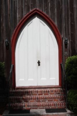
On Okatie Hwy (State Highway 170), on the right when traveling south.
This sanctuary, built 1824 as St. Luke's
Episcopal Church, housed an active
Episcopal congregation until just before
the Civil War. It was sold to the
trustees of St. Luke's Methodist
Church in 1875 and served that
congregation since. St. . . . — — Map (db m19645) HM
On Beach City Rd, 0.7 miles Dillon Rd, on the right.
Early A.M.E. Missionaries to South Carolina, Rev. James H.A. Johnson and Rev. James A. Handy, arrived at Hilton Head on the Steamship Arago at 3:18 p.m. Friday, May 12, 1865.
Rev. James Lynch, also an A.M.E. Missionary, shared entertainment . . . — — Map (db m104498) HM
On City Beach Rd, 0.3 miles south of Hunter Rd, on the right.
Oldest Baptist church on Hilton Head Island
Organized August 17, 1862
in the town of Mitchelville
with 120 members
Building was moved to present location
later and rebuilt in 1966
Rededicated October 30, 1988
Rev. C.W. Aiken, Pastor . . . — — Map (db m104497) HM
On Beach City Road at Eneterprise Lane, on the right when traveling north on Beach City Road.
This church, organized in 1862, was first located in the town of Mitchelville, a freedman’s village established on Hilton Head by the United States Army. Rev. Abraham Murchinson, its first pastor, was a former slave. The congregation numbered . . . — — Map (db m104580) HM
On Beach City Road, 0.1 miles north of Hunter Road, on the right when traveling north.
(front)
The congregation of Queen Chapel can trace its roots to May 1865 when A.M.E. missionaries Rev. R.H. Cain, Rev. James H.A. Johnson and James A. Handy arrived on Hilton Head Island. They visited the Freedman’s town of Mitchelville . . . — — Map (db m104583) HM
Near Beach City Road, 0.4 miles north of Dillon Road, on the right when traveling north.
Religion in Mitchelville
Before Mitchelville was established, African slaves on the island congregated at impromptu religious services under trees. The churches built in Mitchelville were the center of religious, social, political, and . . . — — Map (db m105172) HM
On Beach City Road at Dillon Road, on the right when traveling north on Beach City Road.
This church, founded in 1886 by former members of First African Baptist Church, is one of the oldest surviving institutions remaining from the town of Mitchelville, a freedmen’s village established here by the United States Army in 1862. The present . . . — — Map (db m44098) HM
On William Hilton Parkway near Mathews Drive and William Hilton Parkway (Route 278), on the right when traveling south.
A Chapel of St. Luke's Parish,
established May 23, 1767, built of
wood shortly after 1786 under the
direction of Captain John Stoney
and Isaac Fripp, was consecrated
in 1833. Members of the Barksdale,
Baynard, Chaplin, Davant, Fripp,
Kirk, . . . — — Map (db m119648) HM
On 11th Street west of Paris Avenue, on the right when traveling west.
The Historic
Union Church
of Port Royal
circa 1878
This property has been
listed in the
National Register
of
Historic Places
by the United States
Department of the Interior — — Map (db m103787) HM
On Lands End Road (State Highway 45), on the left when traveling south.
To St. Helena's Church, Beaufort, S.C. Built about 1740. Made a separate church after the revolution. Burned by forest fire Feb. 22, 1886. — — Map (db m19647) HM
Near Old Sheldon Church Road north of Trask Parkway (U.S. 21), on the right when traveling north.
Church of Prince William's Parish
known as
Sheldon
Built Between 1745-1755
Burned By the British Army 1779
Rebuilt 1826
Burned By the Federal Army 1865 — — Map (db m106086) HM
On Old Sheldon Church Road near Trask Parkway (U.S. 21), on the right when traveling north.
Text from Front Side
Prince William's Parish Church
(Sheldon Church)
These ruins are of Prince William's Parish Church, built ca. 1751-1757 and partially burned during the American Revolution, with its interior and roof rebuilt . . . — — Map (db m106077) HM
On Old Sheldon Church Road north of Bailey Road, on the right when traveling north. Reported permanently removed.
Ruins of Old Sheldon Prince William's Parish Church Built 1745-55. Burned 1779 by British. Rebuilt 1826. Burned 1865 by Federal Army. Named for ancestral home of the Bull family in Warwickshire, England. ——— Annual Services . . . — — Map (db m26366) HM
Near Old Sheldon Church Road north of Trask Parkway, on the right when traveling north.
William Bull
of Sheldon
Born 1683 Son of Stephen Bull,
the Immigrant
Member Colonial House of Commons
1706 - 1719
Colonel of Berkeley County Regiment
Tuscarora and Yemassee Wars.
Lord's Proprietors Deputy 1719.
Member and President . . . — — Map (db m106135)
The Parish of St. Thomas was established by Act of Assembly Nov. 30, 1706. The first church was erected in 1708 and destroyed by forest fire in 1815. The present ediface was erected in 1819. — — Map (db m23368) HM
On Doctor Evans Road (South Carolina Route S-8-444) at Strawberry Chapel Road, on the right when traveling south on Doctor Evans Road.
Chapel of Ease to St. John's (Biggin Church), built about 1725 on land bequeathed by James Child, founder at this place, of the Town of Childbury. Strawberry Ferry was established here by Act of Assembly in 1705. — — Map (db m234406) HM
On Snake River Rd., 0.2 miles south of Old State Road, on the right when traveling east.
The Parish of St. James was founded by Act of Assembly in 1706. The present edifice was begun in 1714, and completed in 1719. The Royal Arms of Great Britain can still be seen over the chancel, and here is preserved the Izard Hatchment, said to be . . . — — Map (db m39091) HM
On Vestry Lane west of Snake River Road (South Carolina Highway S-8-208).
Marker Front:
St. James, Goose Creek was one of the first Anglican parishes in the lowcountry, created by the Church Act of 1706. The first church here , built in 1707, was a frame building. This Georgian brick church, covered in stucco, . . . — — Map (db m29495) HM
On Foster Creek Road at Ford Boulevard on Foster Creek Road.
Bowen's Corner, an African-American farming community from the mid-19th century through the late-20th century, was originally part of a rice plantation established along Goose Creek in 1680. That tract was granted by the Lords Proprietors to Barnard . . . — — Map (db m29500) HM
On Cainhoy Road (State Highway 8-98) at Pompion Hill Lane, on the right when traveling south on Cainhoy Road.
One quarter mile north, the first Church of England ediface outside of Charleston, was erected of Cypress in 1703, largely through the efforts of Gov. Sir Nathaniel Johnson. The present brick structure was erected in 1763. The Parish of St. Thomas, . . . — — Map (db m24463) HM
On Old Macbeth Road (State Highway 8-52) 0.2 miles west of U.S. 52, on the right when traveling west.
(Marker Front) This church grew out of services held as early as 1811, at first in a brush arbor and later at a campground nearby. Ministers riding the Cooper River and Berkeley circuits served this congregation for many years. The first . . . — — Map (db m29335) HM
On State Highway 402, on the right when traveling south.
Parish Church of St. John's Berkeley, founded by Act of Assembly November 30, 1706. Church erected in 1712. Burned by forest fire in 1775 and restored. Burned by Col. Coates of the British Army in 1781 and again restored. Burned again by forest fire . . . — — Map (db m23453) HM
On Old Highway 52 (State Highway S-8-791) at Avanti Lane, on the right when traveling north on Old Highway 52.
Marker Front:
St. James, Goose Creek Chapel of Ease
One of two chapels of ease for St. James, Goose Creek Parish stood here on the road to Moncks Corner, about 7 miles from the 1719 parish church. The chapel of ease was a brick building . . . — — Map (db m26255) HM
On Ranger Drive (State Highway 6), on the right when traveling south.
(Front text) This church, one of the oldest Methodist organizations in Berkeley County, was formally
organized about 1825. Circuit riders had preached in the area for more than forty years, and services held under a
brush arbor here . . . — — Map (db m55867) HM
On Sugar Hill Drive (State Highway 8-5) near West Duke Road, on the right when traveling north.
This baptist Church, constituted 1851, constructed the present building here in 1881 on land donated by A.D. Hare, a church trustee. — — Map (db m23900) HM
On Old Gilliard Road (State Highway 27) north of Spring Hill Church Road, on the left when traveling north.
According to tradition, Methodists worshiped here under a brush arbor as early as 1800. On August 2, 1814, Phillip Keller deeded one acre for a Methodist Church and burying ground. Eden and Rebecca Green Thrower deeded an additional acre in 1839. A . . . — — Map (db m29703) HM
On Church Road (State Highway 45) near Brick Church Circle Drive, on the right when traveling west.
St. Stephen’s, built 1767-69, is a fine example of the rural churches built in the S.C. lowcountry before the Revolution. “The Church is one of the handsomest Country Churches in So. Ca. and would be no mean ornament in Charleston,” the Rev. . . . — — Map (db m29329) HM
On Old State Road (U.S. 176) at Jericho Road (State Highway 9-26), on the right when traveling north on Old State Road.
Bishop Francis Asbury stopped in this region in 1801 and 1803. About 1811, a congregation was organized and by 1815 Jericho Meeting House was standing on land given by Jacob Felkel. The present building there was apparently erected before 1850. A . . . — — Map (db m26875) HM
On Mt. Lebanon Road, 0.5 miles west of Old State Road (U.S. 176), on the right when traveling west.
This is the original site of Mt. Lebanon Lutheran Church, organized January 13, 1844, as an extension of the St. Matthew's Church, Creston. Later, Mt. Lebanon Church moved to Cameron about 2 miles NW, dedicated its new building in 1917, and was . . . — — Map (db m27239) HM
On Cameron Road (State Highway 33) near Nate's Store Road (State Highway 9-27), on the right when traveling east.
Shady Grove Methodist Church was an outgrowth of Tabernacle Church, the parent Methodist body of this area. It was built in the early 1800s on land of Adam Holman, has a framework of hewn logs held together with wooden pegs, and has been . . . — — Map (db m26201) HM
On Old Number 6 Highway (State Highway 6) near Sherlock Road, on the left when traveling north.
In 1737-38, the elder Rev. John U. Giessendanner
from Orangeburg began Lutheran work in this
area; this was continued by his nephew until 1749.
By the 1760s, St. Matthew's Lutheran Church near
here was in use. A later building erected at . . . — — Map (db m26240) HM
On Fort Motte Road at Red Clay Road, on the right when traveling north on Fort Motte Road.
St. Matthew's Parish was established by the S.C. Colonial Assembly between 1765 and 1768. The first of four church buildings was erected in Amelia Township c. 1765. The parish church was incorporated by the S.C. General Assembly in 1788 as the . . . — — Map (db m237357) HM
On Old State Road (U.S. 176) at Old Swamp Road (State Highway 9-353), on the right when traveling west on Old State Road.
Sandy Run Church
This Lutheran church, one of the oldest in the state, is thought to have been organized ca.1765. By 1774, the Rev. Lewis Hochheimer was minister here. The church was incorporated in 1788 as "The German Lutheran Church of Salem, . . . — — Map (db m28827) HM
On Old State Road (U.S. 176) near Old Swamp Road (State Highway 9-353), on the left when traveling east.
Lutheran and Reformed (Calvinistic)
Congregations were worshiping in
a church three miles north of this
site prior to the year 1751. The
church was incorporated in
1788 under the name German
Lutheran Church of Salem on
Sandy Run but later . . . — — Map (db m28386) HM
On McCords Ferry Road (South Carolina Route 267) at Dusty Lane, on the right when traveling south on McCords Ferry Road.
(side 1)
In 1841, St. Matthews Lutheran Church (5 mi. W) directed Rev. J.P. Margart to begin holding services in the nearby Pine Grove community. On September 27, 1847, congregants
formally organized as Pine Grove Lutheran Church. They . . . — — Map (db m220281) HM
On Fort Motte Road (State Highway 419), on the left when traveling south.
The first church built by African Americans at Fort Motte grew out of services held by slaves at nearby Bellville, Goshen, Lang Syne, and Oakland plantations. It was formally organized in 1867 by Caleb Bartley, Israel Cheeseborough, Cudjo . . . — — Map (db m26789) HM
On Ocean Highway (U.S. 17) 0.1 miles north of 15 Mile Landing Road (South Carolina Highway 10-584), on the right when traveling south.
Congregationalists from New England
built a church near here around 1700.
Troops from both sides camped on the
grounds during the American Revolution.
Burned by the British in 1782, it was
rebuilt in 1786.
The building was abandoned . . . — — Map (db m16308) HM
Near Fifteen Mile Landing Road, 0.1 miles west of Ocean Highway (U.S. 17), on the right when traveling west.
This Stone marks the spot where the Wappetow Independent Congregational Church stood. This church was planted here in 1696 by a colony of 52 who came from New England and landed at Seewee Bay. — — Map (db m206024) HM
On Hasell Street, on the right when traveling west.
Founded 1750
The Cradle of Reformed Judaism
In The United States, 1824
Jews who settled in Charleston as early as
1695 worshipped informally until the founding
of this congregation in 1750. First synagogue
on this site, 1780-1792, was a . . . — — Map (db m52396) HM
On Hasell Street, on the right when traveling west.
Has Been Designated A
National
Historic Landmark
This Site Possesses National Significance
in Commemorating the History of the
United States of America
1980
Heritage Conservation and Recreation Service . . . — — Map (db m52964) HM
On Meeting Street north of Ladson Street, on the left when traveling north.
This Georgian-era dwelling was constructed as the parsonage for St. Michael's Church by master builders Martin Miller & John Fullerton, one of the earliest known partnerships of house builders in colonial Charleston. Reverend Robert Cooper, the . . . — — Map (db m242804) HM
On Ashley River Road (South Carolina Route 61) 0.1 miles south of Plainview Road, on the right when traveling north.
St. Andrew's Parish Church was one of ten Anglican churches established in S.C. by the Church Act of 1706.
The church was built in 1706, expanded in 1723, and restored in 1764 after a fire. It is the only extant colonial cruciform church in . . . — — Map (db m242802) HM
On Hasell Street, on the left when traveling west.
The Roman Catholic Church
of
St. Mary's Charleston
Established 1789
Incorporated February 19, 1791
The first Roman Catholic Church in
South Carolina, North Carolina, and Georgia.
This is the third structure on this site.
The . . . — — Map (db m53004) HM
On Calhoun Street, on the right when traveling east.
Founded 1818 by the Reverend Morris Brown
Closed by State Law 1834. Reopened By The Reverend R.H. Cain 1865
Present Edifice Built By The Reverend L.R. Nichols 1891
Redecoration By The Reverend F.R. Veal 1949
The Right Reverend F.M. Reid, . . . — — Map (db m219129) HM
On Calhoun Street, on the right when traveling west.
Bicentennal
Historical Marker
Emanuel African Methodist Episcopal Church
Charleston, South Carolina
Commemorating the unique ministry of South Carolina born bishops, elected in the first century of the
Connection- . . . — — Map (db m52010) HM
The oldest African Methodist Episcopal (A.M.E.) church in the south, Emanuel A.M.E. Church was organized as
Hampstead Free African church in 1818 by Rev. Morris Brown. After seceding from the Methodist Church,
Charlestonians organized three . . . — — Map (db m51900) HM
On Wentworth Street, 0.1 miles west of Anson Street, on the left when traveling east.
November 18, 1866 Bishop Patrick N. Lynch purchased a Jewish synagogue at 34 Wentworth Street and its adjacent property to establish a church for African American Catholics and approximately two years later he dedicated St. Peter's Catholic Church. . . . — — Map (db m31846) HM
On Anson Street, on the left when traveling north.
1822 Organized as a place of worship for those
could not afford to rent pews in existing churches.
1824 Church built on Guingard St. as the first "free"
Church of the Episcopal Church in the United States. . . . — — Map (db m170910) HM
On East Bay Street (U.S. 52), on the right when traveling south.
Moses C. Levy, a Polish born King Street merchant, built this valuable Federal style single house between 1811 and 1816. The house is located on land originally owned by Henry Laurens, one of the wealthiest merchants in the United States and . . . — — Map (db m51808) HM
On Hasell Street at Maiden Lane, on the right when traveling east on Hasell Street.
Trinity Methodist Church Original Site
The first Trinity Church building was erected on this site in 1792. By 1813, Trinity had joined the S. C. Conference, and in 1874 it merged with Cumberland Church, the oldest Methodist church in . . . — — Map (db m31850) HM
On Line Street near Percy Street, on the right when traveling east.
Calvary Church was founded in 1847 to establish a special church for slaves in the Charleston community. Father Paul Trapier held services in March 1848 for the congregation in the basement of St. Philip's parsonage and in mid-July services were . . . — — Map (db m50924) HM
On Line Street near Percy Street, on the left when traveling east.
This church, located on Beaufain Street for 91 years, was organized in 1847 to give free blacks and slaves in
antebellum Charleston a separate Episcopal congregation of their own. The Rev. Paul Trapier was its first minister,
and the church . . . — — Map (db m50686) HM
On Church Street, on the left when traveling north.
Colonel William Rhett, born in London in 1666,
arrived at Charles Towne in 1694.
In 1712 he built and lived at 54 Hasell Street,
thought to be Charleston's oldest dwelling.
A capable military man and sea Captain,
he was commissioned a . . . — — Map (db m47931) HM
Commemorating
Francis Salvador
1747-1776
First Jew in South Carolina to hold public office and to die for American Independence
He came to Charles Town from his native London in 1773 to develop extensive family landholdings in the . . . — — Map (db m27489) HM
This site was the home of the Episcopal Church of the Redeemer. In 1745, Chief Justice of South Carolina Charles Pinckney purchased the property known as Collenton Square. In 1853 Miss Pinckney donated property for a chapel to be built where . . . — — Map (db m19177) HM
On Church Street at Queen Street, on the right when traveling north on Church Street.
The
French Protestant Church
Huguenot
Organized about 1861
First church built in 1867
This building
the third on this site
was erected in 1845
[National Historic Landmark Plaque]:
Huguenot Church
has been . . . — — Map (db m27542) HM
On Cumberland Street, on the right when traveling west.
Established in 1785 under the leadership
of Bishop Francis Asbury, the first Methodist
Society in Charleston purchased a lot in
Cumberland Street and erected a church
here in 1786. Long known as the Blue Meeting
House because of its color and . . . — — Map (db m47974) HM
On Church Street, 0.1 miles north of Queen Street, on the right when traveling north.
Here in the churchyard of
St. Philip's are buried
Charles Pinckney
(1757-1824)
Signer of the United
States Constitution
and author of the famous
"Pinckney Draught"
Governor of South Carolina
U.S. Senator & Congressman . . . — — Map (db m27541) HM
The brickwork below is thought to be from the second of four buildings to house the church.
Constructed in 1732, it was replaced in 1804 by a Robert Mills designed sanctuary, circular in shape. Said to be the largest domed building in the U.S., it . . . — — Map (db m121855) HM
On Pitt Street near Calhoun Street, on the right when traveling south.
Bethel
Methodist Church
lot donated by
Thomas Bennett
A.D. 1795
Church dedicated 1798
Moved across street
for use of colored
people and present
church dedicated
Aug. 7, 1853
Parsonage once
occupied by
Bishop Francis Asbury . . . — — Map (db m47663) HM
On Broad Street at Legare Street, on the left when traveling east on Broad Street.
The cathedral parish was established in 1821 by Bishop John England, the first Bishop of Charleston. The cathedral was named for St. Finbar. A second cathedral church was erected on this site in 1856 under the names of Sts. John and Finbar. This . . . — — Map (db m27465) HM
On this site stood two successive meeting houses and the burial ground of the Society of Friends or Quakers. The site was deeded to the Quakers circa 1681 by South Carolina Governor John Archdale, a prominent Charleston Quaker and owner of a . . . — — Map (db m47876) HM
On Saint Philip Street just north of Beaufain Street, on the right when traveling south.
This land, granted 1680 to John Coming, is part of the glebe given in 1698 to the English Church by Mrs. Affra Coming. The provincial library established in 1698 was in St. Philip’s Church Parsonage which stood on this site until 1858 when a girls’ . . . — — Map (db m141259) HM
On Archdale Street south of Clifford Street, on the right when traveling north.
This church grew from services held for German inhabitants in Charleston by Rev. Johann Martin Boltzius in 1734 and Rev. Henry Melchior Muhlenberg in 1742. The cornerstone of the first house of worship was laid in 1759; the second and present church . . . — — Map (db m11228) HM
On Broad Street, on the right when traveling west.
Sixth Bishop of Charleston, S.C.
Born in Beaufort South Carolina
March 6, 1892
Consecrated Bishop of Charleston
September 8, 1927
Installed as Bishop of Youngstown, Ohio
November 9, 1949
Died in Youngstown, Ohio
March 16, . . . — — Map (db m49684) HM
On King Street near Gateway Walk, on the right when traveling south.
Founded 1787.
Avowedly Unitarian
since 1819
—
One of the oldest
Unitarian Churches
in the United States
and
the oldest one in
the South
O — — Map (db m48237) HM
Unitarian Church has been designated a National Historic Landmark. This site possesses national significance in commemorating the history of the United States of America. — — Map (db m48160) HM
On Calhoun Street near Pitt Street, on the right when traveling west.
(Front text) This church, built in 1797 in the meeting-house form, was dedicated in 1798 and completed
in 1809. It is the oldest Methodist church standing in Charleston. Originally at the corner of Pitt and Calhoun
Streets, Bethel . . . — — Map (db m49375) HM
On Calhoun Street near Pitt Street, on the right when traveling west.
Old Bethel United Methodist Church, the third oldest church building surviving in Charleston, had its beginnings on February 14, 1797 as Bethel Methodist Episcopal Church. Bethel was constructed in the gabled meeting house style with white . . . — — Map (db m50297) HM
On Church Street, on the right when traveling north.
Handsome Adam style
single house and gabled
carrage house was
built on Lot 36 of
Grand Model house.
It has been rectory of
St. Philip's Church since
1908. A successful Scot,
Alexander Christie built
the house as his residence
and . . . — — Map (db m47906) HM
One of the Founders of the American Republic
Born February 25, 1746, Charleston
Member of Provincial Assembly 1769
District Attorney General for South Carolina 1773
Member of Provincial Congress 1775
Officer of the Continental Army . . . — — Map (db m47718) HM
On Concord Street near N Adgers Wharf, on the right when traveling north.
Under his direction, Charleston was fortified, thereby making it one of three walled cities in North America, after Quebec, Canada and St. Augustine, Florida. As commander in chief of the armed forces, he successfully defended Charleston against a . . . — — Map (db m39219) HM
On Logan Street, on the right when traveling north.
Church built in 1835
Destroyed by fire 1861
Merged with Christ Church
Rutledge Ave. and Sumter St.
which was torn down and
new St. Peter's built in 1931
Moved to Miles Drive 1973 — — Map (db m48854) HM
On Meeting Street at Tradd Street, on the right when traveling south on Meeting Street.
Originally founded by twelve Scottish families, it was familiarly known in its early history as the Scots' Kirk.
The present church replaced an earlier one, which had been enlarged once before the American Revolution and twice afterwards. . . . — — Map (db m39315) HM
On Church Street, 0.1 miles south of Tradd Street, on the right when traveling south.
Evidence suggests that this house was built after Julius Lilyestrom Lee purchased the property in 1877 for $1,000 from Mary Gadsden and Susan Gibbes, descendants of Joseph Ball. As early as 1879, Lee and business partner Antonio Nielson based their . . . — — Map (db m187608) HM
On Broad Street, 0.1 miles west of Meeting Street, on the left when traveling east.
Erected in the post-Revolutionary
period on a part of the land once
known as Archdale's Square, was
occupied the Charleston branch of
the First Bank of the United States
prior to 1800. Acquired in 1833
by the Hebrew Orphan Society, it . . . — — Map (db m27448) HM
On Ashley River Road (SC Highway 61) near Plainview Rd, on the right when traveling north. Reported missing.
Built in part in 1706, the year the Church of England was established here by law. Enlarged 1723. Burned out and re-built 1764. Scene of early missionary work among the Negroes. — — Map (db m242440) HM
On Bohicket Road (State Highway 10-20) near Donnelly Lane, on the right when traveling south.
Founded by early English, Scottish, and French settlers about 1710, this is one of the oldest Presbyterian congregations in South Carolina. The original sanctuary, believed to have been built about 1719, was enlarged in 1823. — — Map (db m121854) HM
On Old Georgetown Rd. (dirt), on the right when traveling south.
[Front]
Erected in 1768, this edifice, officially known as Wambaw Church, was situated on the King's Highway. It is the fourth church to serve St. James Santee Parish. The parish, founded in 1706 at the request of French Huguenot . . . — — Map (db m39044) HM
Brickyard Plantation is a portion of the vast Boone Hall Plantation. The soils that cover much of the tract contain dense red clay and sand making it suitable for brick production. In 1817, “a plantation with a Brick Yard established thereon . . . — — Map (db m36681) HM
Near U.S. 17,701 near Old Georgetown Road (South Carolina Highway 10-1808), on the right when traveling north.
Foundation Laid in 1707
The first clergyman in 1708
Rev.Edward Marston and Vestry follows
David Maybank and Henry Gill, Wardens
Thomas Barton, William Capers,
Leonard Hickman, John Simes,
Richard Fairchild, John Hale,
and . . . — — Map (db m38865) HM
On U.S. 17 near opposite Long Point Road, on the right when traveling north.
The Church Act of 1706 created Christ Church Parish. The first church, a wooden structure built in 1707, accidentally burned in 1725. A brick church was erected in 1726, and although the British burned it in 1782 and the interior was destroyed by . . . — — Map (db m38264) HM
On Royall Avenue, on the right when traveling north.
(Front text) This church, founded during Reconstruction, has been at the same site since 1890. The first sanctuary serving this congregation was located on Hibben Street and built on a lot leased by the Town of Mount Pleasant in 1877. After . . . — — Map (db m39427) HM
On Mathis Ferry Road (State Highway 10-56) near North Shelmore Blvd., on the right when traveling south.
(Front text)
Jacob Bond I'On (1782-1859), planter, U.S. Army and militia officer, and state legislator, is buried in the family cemetery 1/2 mi. north. I'On, a contemporary of John C. Calhoun at Yale University, represented St. James . . . — — Map (db m37964) HM
On Hibben Street near Church Street, on the right when traveling west.
Erected about 1854 and originally a Congregational Church affiliated with Old Wappetaw Church, founded about 1699. Served as a Confederate hospital during the Civil War, then briefly housed the Laing School for freedmen during Reconstruction. Was . . . — — Map (db m39620) HM
Side A Reverend Andrew Fowler was elected rector of Christ Church in 1828. He bought a village home on Whilden Street where he held services for 40 people from June to Advent to avoid the malaria-plagued sickly season. Services were held at . . . — — Map (db m37819) HM
On State Highway 162, on the right when traveling east.
St. Paul's, Stono St. Paul’s Parish, one of the ten original parishes of colonial S.C., was created by the Church Act of 1706. The first parish church was built in 1708 on a bluff overlooking the Stono River. The parsonage and outbuildings were . . . — — Map (db m39900) HM
Near Middle Street at Osceola Avenue, on the left when traveling east.
1902-1947
This one-story brick structure was built in 1902 by the US Army Corps of Engineers for the storage of torpedoes and equipment used to defend Charleston Harbor by the United States Army.
1950-1953
After the US Army left in 1947, this . . . — — Map (db m225171) HM
On Ashley River Road (South Carolina Route 61) 0.1 miles south of Plainview Road, on the right when traveling north.
On March 22, 1780, British and Hessian troops nearing Charleston were met by Patriot cannon fire near St. Andrew's Parish Church.
They advanced on the church from the opposite side of Church Creek after reports that a Patriot detachment of 150 . . . — — Map (db m242464) HM
On East Buford Street just west of Laurel Street, on the right when traveling west.
Dunton Chapel Methodist Church can trace its origins to 1870 when Rev. J.R. Rosemond began preaching in the home of Milton Hardy. The church was built c. 1878, but has undergone many renovations, including being brick veneered in 1937. Originally . . . — — Map (db m196183) HM
On E Floyd Baker Blvd, on the right when traveling west.
[Lower marker]:
First Baptist Church
Founded 1878
Built 1899
B.P. Robertson, Pastor
[Upper marker]
Corner stone from second auditorium building which was demolished September 1949 to make way for the present building . . . — — Map (db m7554) HM
On Goucher Creek Road, on the left when traveling south.
(Front) This church, the oldest in the Broad River Association, was founded in 1770 and was first called Thicketty Branch Baptist Church. After meeting in a brush arbor and area houses, it built its first permanent church, a log building, . . . — — Map (db m59075) HM
[East Face]:
Erected
to the Memory
of
The Reverend
Thomas Curtis, D.D.
by his affectionate
and
devoted pupils.
[West Face]:
He was born
May 10, 1797 in the town
of Wisbfach England.
And was lost . . . — — Map (db m7281) HM
On Asbury Road (State Highway 211), on the right when traveling west.
This African American church, the first in what is now Cherokee County, was most likely built between 1880 and 1890. It served the Whig Hill, Asbury, and Thickety communities of what was Union County before Cherokee County was created in 1897. . . . — — Map (db m19724) HM
On State Highway 97 at Old Catholic Church Road, on the right when traveling east on State Highway 97.
Divergent Presbyterian groups held services in this area as early as 1759. Rev. William Richardson, active in the area, is credited with unifying and naming them in 1770. The cemetery contains many graves of Revolutionary and Confederate . . . — — Map (db m13687) HM
694 entries matched your criteria. Entries 101 through 200 are listed above. ⊲ Previous 100 — Next 100 ⊳