After filtering for South Carolina, 403 entries match your criteria. The first 100 are listed. ⊳
Colonial Era Topic
By Brian Scott, January 17, 2009
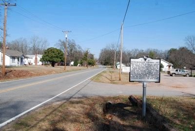
Boonesborough Township (1763) Marker -
Looking North Along Highway 184
Looking North Along Highway 184
| 1 ► South Carolina, Abbeville County, Donalds — 1-9 — Boonesborough Township (1763) — |
| On West Main Street (State Highway 184) north of Brooks Lane, on the left when traveling south. | |||
| 2 ► South Carolina, Abbeville County, Donalds — Templeton-Drake Cabin ca. 1764 — |
| On West Main Street (State Highway 184) south of Austin Road, on the right when traveling south. | |||
| 3 ► South Carolina, Abbeville County, Due West — 1-6 — Due West — |
| On North Main Street (State Highway 184) at College Street (State Highway 20), on the left when traveling south on North Main Street. | |||
| 4 ► South Carolina, Aiken County, Beech Island — 2-9 — Savannah Town / Fort Moore — |
| On Sandbar Ferry Road (State Highway 28). | |||
| 5 ► South Carolina, Aiken County, Jackson — William Bartram Trail — Traced 1773-1777 — South Atlantic Region — |
| Near Silver Bluff Road (County Highway 314) 0.4 miles north of Bluff Landing Road (County Highway 315), on the left when traveling north. | |||
| 6 ► South Carolina, Aiken County, Perry — 2 58 — Indian Head / The Middle Road — |
| On John Nunn Highway (State Highway 389) 0.5 miles east of Poole Road, on the right when traveling east. | |||
| 7 ► South Carolina, Aiken County, Salley — Capt. Dempsey Hammond Salley — 1838 - 1903 — |
| On West Railroad Avenue (State Highway 39) near Pine Street, on the left when traveling north. | |||
| 8 ► South Carolina, Aiken County, Salley — The Salley Family — |
| On West Railroad Avenue (State Highway 39) near Pine Street, on the right when traveling south. | |||
| 9 ► South Carolina, Bamberg County, Bamberg — 5-10 — Woodlands — |
| On Heritage Highway (U.S. 78), on the left when traveling west. | |||
| 10 ► South Carolina, Barnwell County, Barnwell — 6-20 — Red Hill At Turkey Creek — |
| On Dunbarton Blvd (State Route 64) (U.S. 278) near Gilmore Street, on the right when traveling east. | |||
| 11 ► South Carolina, Barnwell County, Owens Crossroads — 6-1 — Winton County Court House Site — 1.4 Miles »—→ — |
| On SC 3, on the right when traveling south. | |||
| 12 ► South Carolina, Beaufort County, Beaufort — 7-1 — Beaufort — |
| On Boundary Street (U.S. 21) near Ribaut Road, on the right when traveling west. | |||
| 13 ► South Carolina, Beaufort County, Beaufort — Beaufort County, South Carolina — Exploration and Settlement — |
| 14 ► South Carolina, Beaufort County, Beaufort — Beaufort County, South Carolina — Colonial And Revolutionary Period — 1711-1860 — |
| 15 ► South Carolina, Beaufort County, Beaufort — Colonel John Barnwell — "Tuscarora Jack" — |
| Near Newcastle Street north of North Street, on the left when traveling north. | |||
| 16 ► South Carolina, Beaufort County, Beaufort — Dr. Henry Woodward, Surgeon 1646-1686 — (First Permanent Settler of South Carolina) — |
| Near Craven Street west of Carteret Street (Business U.S. 21), on the right when traveling west. | |||
| 17 ► South Carolina, Beaufort County, Beaufort — First Fort |
| On Bay Street near Scott Street, on the right when traveling east. Reported missing. | |||
| 18 ► South Carolina, Beaufort County, Beaufort — Verdier House — |
| On Bay Street, on the right when traveling west. | |||
| 19 ► South Carolina, Beaufort County, Hilton Head Island — 7-18 — Fish Hall Plantation — |
| On Fish Haul Road near Mitchelville Road, on the right when traveling east. | |||
| 20 ► South Carolina, Beaufort County, Hilton Head Island — 7-11 — Hilton Head — |
| On Fort Walker Drive near Circle at Catesby Lane, on the right when traveling east. | |||
| 21 ► South Carolina, Beaufort County, Hilton Head Island — In Memoriam — Captain John Stoney — 1749 - 1821 — |
| Near Mathews Drive at Folly Field Road and William Hilton Parkway (U.S. 278). | |||
| 22 ► South Carolina, Beaufort County, Hilton Head Island — 7-12 — Zion Chapel of Ease and Cemetery — |
| On William Hilton Parkway near Mathews Drive and William Hilton Parkway (Route 278), on the right when traveling south. | |||
| 23 ► South Carolina, Beaufort County, Parris Island — # 74001822 — Charlesfort-Santa Elena Site — |
| On Belleau Wood Road, on the right. | |||
| 24 ► South Carolina, Beaufort County, Parris Island — Parris Island Plantations — |
| On Belleau Wood Road, in the median. | |||
| 25 ► South Carolina, Beaufort County, Pinckney Island — 07-19 — Charles Cotesworth Pinckney — (1746–1825) — |
| On Pinckney Wildlife Refuge near William Wilton Parkway (U.S. 278), on the right. | |||
| 26 ► South Carolina, Beaufort County, Sheldon — Church of Prince William's Parish — |
| Near Old Sheldon Church Road north of Trask Parkway (U.S. 21), on the right when traveling north. | |||
| 27 ► South Carolina, Beaufort County, Sheldon — 7-4 — Prince William's Parish Church — (Sheldon Church) — |
| On Old Sheldon Church Road near Trask Parkway (U.S. 21), on the right when traveling north. | |||
| 28 ► South Carolina, Beaufort County, Sheldon — William Bull — |
| Near Old Sheldon Church Road north of Trask Parkway, on the right when traveling north. | |||
| 29 ► South Carolina, Berkeley County, Cainhoy — 8-13 — St. Thomas Church — |
| On Cainhoy Road (State Highway 8-98). | |||
| 30 ► South Carolina, Berkeley County, Cordesville — 8-8 — Mepkin Plantation — |
| On Dr. Evans Road (State Highway 8-44), on the right when traveling north. | |||
| 31 ► South Carolina, Berkeley County, Cordesville — 8-20 — Strawberry Chapel — |
| On Doctor Evans Road (South Carolina Route S-8-444) at Strawberry Chapel Road, on the right when traveling south on Doctor Evans Road. | |||
| 32 ► South Carolina, Berkeley County, Cross — 8- 22 — Berkeley County — |
| On Old Number Six Highway (State Highway 6 / 45) at County Line Road (State Highway 8-59), on the right when traveling east on Old Number Six Highway. | |||
| 33 ► South Carolina, Berkeley County, Cross — 8-15 — Thomas Sumter's Store — |
| Near Old Number Six Highway (State Highway 6 / 45) near Nicholas Drive, on the right when traveling west. | |||
| 34 ► South Carolina, Berkeley County, Goose Creek — 8-45 — Boochawee Hall — |
| On a Lake Greenview Park walking trail near East Pandora Drive. | |||
| 35 ► South Carolina, Berkeley County, Goose Creek — 8-55 — Broom Hall Plantation — |
| On Westview Blvd. near Prospect Way, on the right when traveling north. | |||
| 36 ► South Carolina, Berkeley County, Goose Creek — 8-46 — Button Hall — |
| On Brandywine Boulevard east of North Goose Creek Boulevard (U.S. 52). | |||
| 37 ► South Carolina, Berkeley County, Goose Creek — 8-56 — Crowfield Plantation — |
| On Hamlet Circle, in the median. | |||
| 38 ► South Carolina, Berkeley County, Goose Creek — 8-57 — Early Indian Trading Paths / The Goose Creek Men — |
| Near North Goose Creek Boulevard (U.S. 52) when traveling south. | |||
| 39 ► South Carolina, Berkeley County, Goose Creek — 8-71 — Eighteen Mile House Tavern — |
| On Saint James Avenue (U.S. 176) north of Wilmer Avenue, on the right when traveling south. | |||
| 40 ► South Carolina, Berkeley County, Goose Creek — 8-50 — Goose Creek / City of Goose Creek — |
| On St. James Avenue (U.S. 176) at Farm Road, on the right when traveling south on St. James Avenue. | |||
| 41 ► South Carolina, Berkeley County, Goose Creek — 8-6 — Goose Creek Church — |
| On Snake River Rd., 0.2 miles south of Old State Road, on the right when traveling east. | |||
| 42 ► South Carolina, Berkeley County, Goose Creek — 8-41 — Howe Hall Plantation / Howe Hall — |
| On Liberty Hall Road. | |||
| 43 ► South Carolina, Berkeley County, Goose Creek — 8-42 — Howe Hall Plantation / Howe Hall Elementary School — |
| On Howe Hall Road near Red Bank Road, on the left when traveling east. | |||
| 44 ► South Carolina, Berkeley County, Goose Creek — 8-44 — Liberty Hall Plantation — |
| On Woodward Road at Adler Drive on Woodward Road. | |||
| 45 ► South Carolina, Berkeley County, Goose Creek — 8-29 — Otranto Indigo Vat — |
| On Brushy Park Road, on the right when traveling north. | |||
| 46 ► South Carolina, Berkeley County, Goose Creek — 8-27 — Otranto Plantation — |
| On Otranto Boulevard, on the right when traveling east. | |||
| 47 ► South Carolina, Berkeley County, Goose Creek — 8-40 — Springfield Plantation — |
| On Judy Drive. | |||
| 48 ► South Carolina, Berkeley County, Goose Creek — 8-54 — The Oaks — |
| On The Oaks Avenue at Middleton Drive on The Oaks Avenue. | |||
| 49 ► South Carolina, Berkeley County, Goose Creek — 8-61 — The Yamasee War At Goose Creek, 1715 — |
| On a Foster Creek Park walking trail west of Foster Creek Road. | |||
| 50 ► South Carolina, Berkeley County, Huger — 8-21 — Silk Hope Plantation — |
| On State Highway 402 near Silk Hope Drive. | |||
| 51 ► South Carolina, Berkeley County, Jamestown — 8-17 — Old Jamestown — |
| On French Santee Road (State Highway 45) at Mt. Moriah Avenue, on the left when traveling south on French Santee Road. | |||
| 52 ► South Carolina, Berkeley County, Moncks Corner — Berkeley County Museum and Heritage Center: A County's Story — |
| On Stoney Landing Road, 0.8 miles east of Rembert C Dennis Boulevard (Bypass Highway 52), on the right when traveling east. | |||
| 53 ► South Carolina, Berkeley County, Moncks Corner — 8-9 — Biggin Church — |
| On State Highway 402, on the right when traveling south. | |||
| 54 ► South Carolina, Berkeley County, Moncks Corner — Colleton House: “Unmanly Practices” or Legitimate Target? — |
| Near Stony Landing Road. | |||
| 55 ► South Carolina, Berkeley County, Moncks Corner — 8-68 — Fairlawn Plantation / Fort Fairlawn — |
| On Rembert C Dennis Blvd. near Edward Drive, on the right when traveling north. | |||
| 56 ► South Carolina, Berkeley County, Moncks Corner — First Site of Moncks Corner — |
| On U.S. 52 north of North Live Oak Drive (U.S. 17A), on the right when traveling north. | |||
| 57 ► South Carolina, Berkeley County, Moncks Corner — Fort Fair Lawn: An Archeaological Treasure — |
| Near Stony Landing Road. | |||
| 58 ► South Carolina, Berkeley County, Moncks Corner — 8-16 — Lewisfield Plantation — |
| On Old US 52 at Lewisfield Plantation Road, on the right when traveling north on Old US 52. | |||
| 59 ► South Carolina, Berkeley County, Moncks Corner — 8-4 — Mulberry Plantation — |
| Near Old US 52 at N. Mulberry Drive, on the right when traveling north. | |||
| 60 ► South Carolina, Berkeley County, Moncks Corner — 8-2 — Old Moncks Corner — |
| On North Live Oak Drive (U.S. 17A) at U.S. 52, in the median on North Live Oak Drive. | |||
| 61 ► South Carolina, Berkeley County, Moncks Corner — Stony Landing House — Circa 1840-1850 — |
| Near Old Stony Landing Road. | |||
| 62 ► South Carolina, Berkeley County, Moncks Corner — Too Formidable to Take — Fort Fair Lawn Historic Site — The Liberty Trail S.C. — |
| Near Stoney Landing Road, 0.8 miles east of Rembert C Dennis Boulevard (Bypass U.S. 52), on the right when traveling east. | |||
| 63 ► South Carolina, Berkeley County, Moncks Corner — 8-23 — Wadboo Barony — |
| On State Highway 402, on the left when traveling south. | |||
| 64 ► South Carolina, Berkeley County, Moncks Corner — Wadboo Barony: Francis Marion’s Last Headquarters — |
| Near State Highway 402 just north of State Highway S-8-44, on the left when traveling west. | |||
| 65 ► South Carolina, Berkeley County, Moncks Corner — 8-62 — Wassamassaw — |
| On Wassamassaw Lane, 0.3 miles north of U.S. 176, on the right when traveling north. | |||
| 66 ► South Carolina, Berkeley County, Mount Holly — 8-19 — Medway Plantation — |
| On U.S. 52 at Medway Road (State Highway 8-667), on the right when traveling north on U.S. 52. | |||
| 67 ► South Carolina, Berkeley County, Mt. Holly — 8-49 — Thorogood Plantation / Mount Holly Plantation — |
| Near Mt. Holly Aluminum Driveway near North Goose Creek Boulevard (U.S. 52), on the right when traveling west. | |||
| 68 ► South Carolina, Berkeley County, Pineville — Village of Eadytown — |
| On State Highway 45 at Old Canal Road, on the left when traveling north on State Highway 45. | |||
| 69 ► South Carolina, Berkeley County, Santee Circle — Site of Huguenot Church of Saint John's Berkeley — |
| On Old Blackoak Road, 2 miles west of Highway 52, on the right when traveling south. | |||
| 70 ► South Carolina, Berkeley County, Spring Hill — 8- 22C — Berkeley County — |
| On Old State Road (US 176), on the right when traveling south. | |||
| 71 ► South Carolina, Berkeley County, St. Stephen — 8-22A — Berkeley County — |
| On U.S. 52, on the right when traveling south. | |||
| 72 ► South Carolina, Calhoun County, Creston — 9-4 — St. Matthew's Lutheran Church — Parent Lutheran Church of This Area — |
| On Old Number 6 Highway (State Highway 6) near Sherlock Road, on the left when traveling north. | |||
| 73 ► South Carolina, Calhoun County, Fort Motte — 9 11 — St. Matthew's Parish — |
| On Fort Motte Road at Red Clay Road, on the right when traveling north on Fort Motte Road. | |||
| 74 ► South Carolina, Calhoun County, St. Matthews — Honoring a Pioneer Woman — |
| On Old Number 6 Highway (State Highway 6) at Bluebird Trail, on the right when traveling south on Old Number 6 Highway. | |||
| 75 ► South Carolina, Charleston County, Awendaw — Wappetow Independent Congregational Church — |
| Near Fifteen Mile Landing Road, 0.1 miles west of Ocean Highway (U.S. 17), on the right when traveling west. | |||
| 76 ► South Carolina, Charleston County, Charleston — David Ramsay House — c. 1740 — |
| On Broad Street, 0.1 miles King Street, on the left when traveling east. | |||
| 77 ► South Carolina, Charleston County, Charleston — 10-14 — Drayton Hall / Drayton Family — |
| On 3380 Ashley River Road (SC-61), on the right when traveling north. | |||
| 78 ► South Carolina, Charleston County, Charleston — Magnolia Plantation — 1676 — |
| On 3550 Ashley River Rd (SC-61), on the right when traveling north. | |||
| 79 ► South Carolina, Charleston County, Charleston — Old St. Michael’s Rectory — 39 Meeting Street — Built c. 1767 — |
| On Meeting Street north of Ladson Street, on the left when traveling north. | |||
| 80 ► South Carolina, Charleston County, Charleston — Royal Judge John Drayton — |
| On 3550 Ashley River Rd, on the right when traveling north. | |||
| 81 ► South Carolina, Charleston County, Charleston, Ansonborough — Col. William Rhett House — 54 Hasell Street — circa 1712-1720 — |
| On Hasell Street at Maiden Lane, on the left when traveling east on Hasell Street. | |||
| 82 ► South Carolina, Charleston County, Charleston, Ansonborough — The Liberty Tree — |
| On Alexander Street, 0.1 miles north of Calhoun Street, on the right when traveling north. | |||
| 83 ► South Carolina, Charleston County, Charleston, Ansonborough — 10-43 — William Rhett House — |
| On Hasell Street at Maiden Lane, on the right when traveling east on Hasell Street. | |||
| 84 ► South Carolina, Charleston County, Charleston, French Quarter — City Hall — |
| On Broad Street at Meeding Street, on the right when traveling west on Broad Street. | |||
| 85 ► South Carolina, Charleston County, Charleston, French Quarter — Colonel William Rhett — |
| On Church Street, on the left when traveling north. | |||
| 86 ► South Carolina, Charleston County, Charleston, French Quarter — Elizabeth Timothy — |
| On Vendue Range Street east of East Bay Street. | |||
| 87 ► South Carolina, Charleston County, Charleston, French Quarter — Francis Salvador — |
| Near Meeting Street at Broad Street. | |||
| 88 ► South Carolina, Charleston County, Charleston, French Quarter — George Washington Statue — |
| Near Meeting Street near Broad Street, on the right. | |||
| 89 ► South Carolina, Charleston County, Charleston, French Quarter — Powder Magazine Flags — |
| Near Cumberland Street. | |||
| 90 ► South Carolina, Charleston County, Charleston, French Quarter — Robert Gibbes — 1644-1715 — |
| Near Meeting Street at Broad Street. | |||
| 91 ► South Carolina, Charleston County, Charleston, French Quarter — The Douxsaint House — |
| On Church Street at Chalmers Street, on the right when traveling north on Church Street. | |||
| 92 ► South Carolina, Charleston County, Charleston, French Quarter — The Nicholas Trott House — 83 Cumberland Street — |
| On Cumberland Street, on the left when traveling west. | |||
| 93 ► South Carolina, Charleston County, Charleston, French Quarter — The Old Exchange — |
| On East Bay Street. | |||
| 94 ► South Carolina, Charleston County, Charleston, French Quarter — The Old Powder Magazine — |
| On Cumberland Street, 0.1 miles west of Church Street, on the left when traveling west. | |||
| 95 ► South Carolina, Charleston County, Charleston, French Quarter — The Site of Carteret Bastion — |
| On Meeting Street at South Market Street, on the right when traveling south on Meeting Street. | |||
| 96 ► South Carolina, Charleston County, Charleston, French Quarter — The Site of Craven Bastion — |
| On East Bay Street (U.S. 52 Spur). | |||
| 97 ► South Carolina, Charleston County, Charleston, French Quarter — Trott's Cottage — First Brick Dwelling — c.1709 — |
| On Cumberland Street, 0.1 miles west of Church Street, on the left when traveling west. | |||
| 98 ► South Carolina, Charleston County, Charleston, Harleston Village — Affra Harleston Coming — |
| On Glebe Street near Wentworth Street, on the left when traveling north. | |||
| 99 ► South Carolina, Charleston County, Charleston, Harleston Village — Charleston Work House — |
| On Magazine Street west of Logan Street, on the left when traveling west. | |||
| 100 ► South Carolina, Charleston County, Charleston, Harleston Village — Home of Doctor John Lining — |
| On Broad Street at King Street, on the left when traveling east on Broad Street. | |||
403 entries matched your criteria. The first 100 are listed above. Next 100 ⊳