The Hydraulics
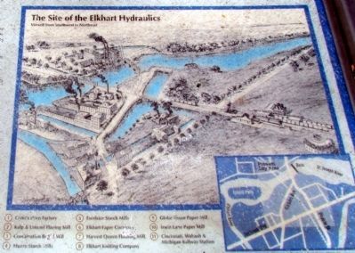
Elkhart's early development as an industrial city can be attributed to its proximity to several waterways. Before the advent of electric power, the early industry pioneers harnessed the power of the river flow to provide the . . . — — Map (db m69752) HM
Built as a source of hydraulic power for Goshen's industries, the Millrace Canal gave rise to a new form of energy in the late 1890's - electricity. In 1898 the energy of the canal was harnessed by the Hawks Electric Company's central generating . . . — — Map (db m64232) HM
Established in 1958, Shanklin Park was named after respected Goshen High School English teacher, Merle Shanklin. Formerly serving as the site of Goshen's landfill, the park has grown into the city's largest and most popular park. Located within . . . — — Map (db m68836) HM
Construction of the Goshen Dam and Millrace Canal began in March of 1867 and was completed on April 18, 1868, the same day Goshen was incorporated as a city. The project was built by a 40 man crew using horses and plows to excavate the canal bed. . . . — — Map (db m64230) HM
1841 Built as Headquarters of
the Whitewater Valley Canal Co.
1854 Savings Bank of Indiana
Home of:
Dr. S. W. Vance 1857-1936
Congressman and Mrs. Finly H. Gray 1936-1947
1947 - 1971 V. F. W. Post 571
1971 - . . . — — Map (db m44760) HM
In 1836 construction began on this fifty-six lock, one hundred one mile canal. Opened from Lawrenceburg to Brookville (1839), it was extended to Laurel and Cincinnati (1843), Connersville (1845), Cambridge City (1846), and Hagerstown (1847). — — Map (db m44741) HM
In 1813 John Graham surveyed and platted a town which the Scribner brothers, founders of the town, named New Albany after Albany, New York. Within five years, the new community became the seat of the newly formed Floyd County. Boat building and . . . — — Map (db m194200) HM
One of the most famous river boats, the Lee was built in 1866 at the riverfront shipyard of Humphrey & Dowerman near this spot. The Lee, racing against the Natchez in 1870, set the river record from New Orleans to St. Louis of 3 days, 18 hours and . . . — — Map (db m193710) HM
In fall 1846, residents of Covington and Attica skirmished at Lock 35 over lack of water to Covington. Heavy rains eventually resolved the problem. Competition among canal towns over water control was often intense. First boat reached Attica 1846 . . . — — Map (db m3284) HM
Shawnee Township
Wabash - Erie Canal
1846 - 1875
The Canal extended from Toledo, Ohio to Evansville, Indiana. Construction on the 376 mile section in Indiana began in 1832 and completed through Fountain County in 1846.
One to six horses in . . . — — Map (db m20364) HM
Did sightseeing, boating or fishing lure you to the park today? This large reservoir offers nine boat ramps, four marinas and two State Recreation Areas, plus campgrounds, beaches, picnic areas, playgrounds, hiking trails and fishing access for . . . — — Map (db m160991) HM
This memorial is dedicated to the flood victims of Whitewater Valley from this spot, which marks "The Fries Homestead" on March 25, 1913, were lost.
Mrs. Margaret Fries, her daughter Mrs. Elizabeth Seiwert, her granddaughter Hedwig Seiwert, . . . — — Map (db m228915) HM
Welcome to the Whitewater Canal Trail. Right now, about 9 miles of the planned 13-mile trail are complete. When the Feeder Dam section of the trail is finished, it will cover the four miles from here to the US 52 trailhead near Metamora. (See . . . — — Map (db m226713) HM
The Ben Franklin III, launched in 1989, was designed and constructed in Pascagoula, Mississippi. Designed as a freighter, the vessel is 75’ long and has a beam (or width) of 12’. Constructed of wood and fiberglass, it holds approximately 75 . . . — — Map (db m164451) HM
"I [have] two degrees in the business of Engineering and have for my pay forty-seven dollars p[e]r month. I have for my companions men of talents and respectability who are like me, far away from their native homes."
Whitewater . . . — — Map (db m227239) HM
Two story frame of Federal style. Built by Jonathan Banes in 1848.
First known as the firm of Jenks Banes & Calvin Jones.
Harry & Alvin Blacklidge 1852-57
Mahlon & Milton Gordon 1857-92
Wm. N. Gordon started banking business in . . . — — Map (db m44796) HM
An aqueduct is a bridge carrying one body of water over another. The Duck Creek Aqueduct was originally built in 1843 to convey the canal over Duck Creek 16 feet below. Flood waters in 1847 destroyed the aqueduct, which was soon replaced by the . . . — — Map (db m55560) HM
Gordon's, or Millville Lock #24, was one of the 56 locks on the Whitewater Canal constructed to accommodate a 491-foot drop in elevation along its course.
The water level could be raised or lowered eight feet. Mitered gates at both ends of the . . . — — Map (db m228919) HM
These engine parts once operated the mill
They're part of a machine called a turbine (TUHR-bine) that used water power to operate the mill beginning in 1872.
Just like a wooden water wheel, water from the canal rotated . . . — — Map (db m175024) HM
Alfred Blacklidge was the original owner of this building. The original building burned in 1885. In the early 1900's. Blacklidge was extending credit to surrounding sharecroppers, when bad times came, forcing many of the farmers to default on their . . . — — Map (db m44904) HM
Built in 1838 by Ezekial Tyner to house his store room and counting room where he acted as agent for canal trade, housing his family in the addition to the rear. He then purchased the land from David Mount in 1841. Thomas Tague acquired the . . . — — Map (db m44902) HM
In 1845, Jonathan Banes built a three-story frame cotton mill, known as Metamora Cotton Factory, on this site. Banes, a former contractor on the canal, converted the cotton factory to a flouring mill in 1856, and sold the mill to John Curry in . . . — — Map (db m44903) HM
This stone building, constructed in the 1840's, was owned and used by a number of families prominent in early history of Metamora. These included Martindale, Watkins, Allison and Wiley. The ground floor was a general merchandising establishment, . . . — — Map (db m44865) HM
The Whitewater Canal Trail follows
a 2.6 mile "water level route" so it is
basically level. It has a solid surface
made of crushed stone, and it is
suitable for walking or bicycling. The
route travels along farm fields and
through a . . . — — Map (db m163370) HM
Landmark building of the canal era.
Drug store 1840 to 1916. Hardware store
1923 to 1961. Front half constructed in
1840s, as canal boats floated by. Back half
built in late 1860s, after civil war. Built
of rock from nearby duck creek. Bears . . . — — Map (db m159964) HM
These four large draft animals supply the
"horsepower” for the state's canal boat. Bill and
Red are Belgian sorrel geldings from Milroy,
Indiana. Tony and Jerry are both Belgian blond
geldings. Tony is from Hagerstown, Indiana,
while . . . — — Map (db m163366) HM
Welcome to the Whitewater Canal Trail. Think of the trail as a path through an eleven-mile park in the Whitewater River Valley. The trail starts at the Laurel Feeder Dam, a small dam that supplies water to the canal.
As you travel to the . . . — — Map (db m228938) HM
This building was built in the 1850's. Mr. Van Camp housed his drug store here, which had the front blown out by a gasoline explosion in 1851. His Mother and himself perished in this tragedy. The building on either side of this were all part of one . . . — — Map (db m44868) HM
Water Wheel
This 12-foot breast water wheel is operational
and provides the power used to operate the grist mill.
From here an underground shaft enters the mill
basement, where the gears and pulleys power the
mill machinery on the first . . . — — Map (db m163367) HM
Important waterway of pioneer commerce. Built 1836 - 47 from Lawrenceburg to Hagerstown, with branch to Cincinnati. Used until 1860. Fifteen-mile section restored by state. — — Map (db m44708) HM
The Whitewater Canal was one of several projects begun by the Indiana Improvement Act of 1836, which was designed to improve transportation and develop commerce state-wide. Constructed to link southeastern and central Indiana, the canal was . . . — — Map (db m59608) HM
The Whitewater Canal was one of several projects begun by the Indiana Improvement Act of 1836, which was designed to improve transportation and develop commerce state-wide. Constructed to link southeastern and central Indiana, the canal was . . . — — Map (db m66862) HM
The Whitewater Canal was one of several projects begun by the Indiana Improvement Act of 1836, which was designed to improve transportation and develop commerce state-wide. Constructed to link southeastern and central Indiana, the canal was . . . — — Map (db m163363) HM
In the 1840s, the canal operations here at Yellow Bank Creek were very impressive. The twin arch aqueduct - a bridge that carried the canal over Yellow Bank Creek was one of the grandest structures along the canal. From this point, you can still . . . — — Map (db m228940) HM
Lock 21, the "Yellow Bank Lock" is an amazing 1830s canal structure. This "combined lock" had rough stone walls that were combined with a double lining of tightly fitted planks to keep the water from leaking through the stone walls. Some of the . . . — — Map (db m228939) HM
It took a network of people to build one of the steepest canals Using detailed plans provided by engineers, construction crews built the 76-mile canal up the steep Whitewater Valley. To raise boats a total of 491 feet, the canal required: • . . . — — Map (db m227916) HM
This is one of 56 locks on the historic Whitewater Canal It is a "cut stone" lock-referring to stone cut from the nearby Laurel quarry. The hammered, dressed and coursed ashlar limestone made a watertight chamber. To raise boats, workers . . . — — Map (db m228917) HM
Yellow Bank Flag Stop
Starting about 1867, the Whitewater Valley Railroad
offered flag stop service here at Yellow Bank. Flag
stops often consisted of little more than a small
shelter to protect waiting passengers from the rain.
Hailing . . . — — Map (db m163371) HM
( At Top - - Canal Map & Points of Interest )
Here is a section of the Wabash & Erie Canal still visible in Gibson County. Construction of the approx. 460 mi. canal. The longest in North America. Began in 1832 & was completed in 1853. One . . . — — Map (db m47806) HM
Princeton abounds in fertile soils from the seasonal flooding of the Wabash, Patoka & White Rivers. Fertile silts were deposited in the riverbeds by glacial outwash at the end of the last glacial period. Archeological records indicate that Native . . . — — Map (db m190588) HM
Many Native American tribes have inhabited the Princeton area over the centuries, including the Piankeshaw, Wea, Shawnee, Deleware, Sac, Fox, Kickapoo, Miami & Pottawatomi tribes. These peoples fished the area's rivers & streams, hunted for buffalo, . . . — — Map (db m207981) HM
Shaped by the last retreating glacier around 10,000 years ago, the Patoka River meanders through sand, gravel & silt deposits left by glacial outwash. The river corridor is home to over 380 species of wildlife, including nesting bald eagles, the . . . — — Map (db m190735) HM
The Princeton you see today is not as it always was. Over billions of years, natural processes have drastically affected the climate, flora & fauna, & even the geographic location of what is now Princeton. Between 420 & 359 million years ago, during . . . — — Map (db m190585) HM
After 1838 land on this side of the river was in the Mississinewa Reservation and Indian land Smith Gilbert established a trading post at the ford. Now seen as smooth rock bottom, in 1823. The year 1849 saw much white activity across the river: . . . — — Map (db m208563) HM
Jacob Furnshell Bugher was born in Guernsey County, Ohio, on January 19, 1826. Growing up, he received his education at the common schools within Guernsey County. At the age of twenty, Mr. Bugher became a teacher, a career in which he was to . . . — — Map (db m215209) HM
These canal-bed earthworks are remnants of construction on the Central Canal from 1836-39. It was planned to link the Hoosier interior with interstate markets, via the Wabash & Erie Canal, as part of the 1836 Internal Improvement Act. Indiana's . . . — — Map (db m41624) HM
Oldest continuous County Fair existing in Indiana. First fair held Sept. 11 - 14, 1860. Citizens met jan. 1860, organized Harrison County Agricultural Society, adopted constitution which with amendments governs yet today. Ground purchased Mar. 1860 . . . — — Map (db m9634) HM
Recovered from the "Alice Dean" steamer, sunk by Gen. Morgan after crossing the Ohio River July 8, 1863
Chain donated by Nina and Gayland Faith — — Map (db m242686) HM
On Tuesday, July 7, 1863, the first units of General Morgan’s cavalry command arrived at Brandenburg, Kentucky. Their mission was to capture boats to be used for ferrying Morgan’s two thousand men across the 800-1,000-yard-wide Ohio River into . . . — — Map (db m126274) HM
The canal boat "Indiana" docked here on the evening of July 3, 1835, opening the Wabash and Erie canal to traffic from Fort Wayne to Huntington. This was the first section of the canal opened in Indiana. John Burk, for whom the lock was named, was a . . . — — Map (db m7546) HM
(Side 1)
Canal Landing on Washington Street. The Huntington Landing started 120 feet west on Washington St and continued to the lock at Cherry St. The Wabash & Erie canal was 4 feet deep and 100 feet wide as this point. Other locks . . . — — Map (db m65223) HM
The junction of the Wabash and Little rivers, 100 yards south, was the western terminus of the Maumee-Wabash long portage and, in 1835, of the first section of the Wabash and Erie Canal. During the 18th century French and English traders passed this . . . — — Map (db m45118) HM
(Side 1)
Huntington's Ford and First Bridge
Pioneers forded Little River From Charles Street diagonally across just below the Island to the Court House. A dugout canoe, when hailed, carried pedestrians across for 50 cents. . . . — — Map (db m65224) HM
In 1835, the Wabash & Erie Canal was completed through this
area. A swatch, 60 feet wide, was cleared before a channel,
40 feet wide and 4 feet deep, was dug by men using picks,
shovels, axes and slip scoops pulled by beasts of burden.
Across . . . — — Map (db m161454) HM
The Wabash & Erie Canal fulfilled George Washington's dream
of connecting the St. Lawrence Seaway with the Gulf of Mexico
by creating a waterway across the only land barrier that lay
between the St. Marys River in Fort Wayne and this site on
the . . . — — Map (db m161453) HM
First lock west of summit level of Wabash and Erie Canal (connected Lake Erie with Ohio River in 1853). Known as Dickey Lock. Built as Lock 1, 1834-1835, of wood construction; renumbered Lock 4 as result of canal completion to Ohio line (1840). . . . — — Map (db m61119) HM
No question about it - Dunn's Bridge is steeped in history. But try to nail down the facts of that history, and questions start to fly. Most local historians agree that a farmer named J.D. Dunn built the bridge. The Kankakee river bisected his . . . — — Map (db m210346) HM
Wild Bill “Pappy” Cantrell Boat and auto racer 1908-1996 Four time Madison Winner 1949 Gold Cup Winner Two time National Champion Inducted Unlimited Hall of Fame and Motorsport Hall of Fame Raced in Indianapolis 500 1948-49-50 Stunt . . . — — Map (db m180863) HM
Flood of 1937 [west side]Although Madisonians are used to the ups and downs of the river, 1937 marked the year of the worst recorded flood in Ohio River history, enveloping the city below First Street. The high water mark is . . . — — Map (db m181338) HM
The completion of Madison's railroad connection to Indianapolis in 1847, the first in the state, heralded the peak of Madison's golden years as a manufacturing city, shipping port, and busy river town. Since the early 1800s, Madison had continued . . . — — Map (db m180813) HM
Indiana's First Railroad [east side]Visible just downriver from here is an abandoned section of track from the first operating railroad in Indiana. The Madison and Indianapolis R.R. began service in 1838, and its famous . . . — — Map (db m181335) HM
Walter Krueger, born in Prussia 1881,
raised in Madison, In
Attended Madison School System
Rose from a Private during the
Spanish-American War to Lt. General
Commanding the 6th Corps. of the Army in WW II.
Attended the Surrender . . . — — Map (db m22059) HM
Madison Regatta [east side]The 4th of July week is celebrated in Madison with fireworks and the firepower of unlimited hydroplane racing. Fast and furious racing marks the Indiana Governor's Cup, with boats reaching speeds of . . . — — Map (db m181379) HM
Railroad on the Riverfront [east side]Factories and mills along Madison's riverfront shipped products by railroad. Tracks ran along the riverfront to the east end of town. A block-long freight station occupied the grassy field . . . — — Map (db m181336) HM
- - - - 1826 - - - -
Built by James Thompson and Isaac Collier.
1850 - Thompson erected larger four-story brick mill. All flour used by Union Army during Civil War ground here.
After a fire in 1872, John A. . . . — — Map (db m66784) HM
On July 4, 1800, the western part of the
Northwest Territory became the Indiana Territory.
It covered land that would eventually be included
in the present states of Indiana, Illinois, Michigan,
Wisconsin, and Minnesota.
Vincennes, on the . . . — — Map (db m23266) HM
Although the Wabash River begins in Ohio, its 475-mile length in Indiana makes it a thoroughly Indiana river. The Miami Indian tribes named it Wah-Bah Shik-Ki which roughly translates as "pure white" and comes from the white limestone riverbed as . . . — — Map (db m176200) HM
Commemorating the patriotism, devotion to duty, valor, energy and seamanship of those Americans who served in the ships
U.S.S. Vincennes
Each a man-of-war, these ships of the United States Navy carried out missions which expanded . . . — — Map (db m61817) HM WM
The USS Indianapolis (SSN 697), a nuclear fast attack, Los Angeles class submarine, was the 3rd ship of the United States Navy to be named for Indianapolis, Indiana. The contract to build her was awarded to the Electric Boat Division of General . . . — — Map (db m187318) HM
LENGTH: 76', WIDTH: 17.5', DISPLACEMENT: 35 tons, DRAFT: 14-22"
Built by Captain Joseph Breeck and launched in 1929
Listed on the National Register of Historic Places Sept. 24, 2009
UNITED STATES DEPT. OF THE INTERIOR
INDIANA . . . — — Map (db m73267) HM
Of the estimated 1,500 shipwrecks in Lake Michigan, there are 14(*) within Indiana waters. Two lie offshore of Gary. They are identified only as "Unknown 5" and "Unknown 6."
"Unknown 5 and 6" have been identified by archeologists as barges . . . — — Map (db m226863) HM
In 1845 Lodner Darvontis Phillips invented and launched the first submarine on the Great Lakes in Trail Creek at the foot of the Old Lighthouse. Phillips designed his submarines for salvage and warfare. His cigar-shaped design was the forerunner of . . . — — Map (db m244320) HM
This lighthouse built in 1858 replaced 1837 lighthouse built at water's edge. Remodeled in 1904. Light placed at end of pier. Seven keepers and fourteen assistant keepers served here 1837-1940. — — Map (db m75722) HM
Roger McKee was a talented and visionary civic leader. This fountain
is dedicated to his decades of public service and humanitarian causes.
His proudest accomplishments were the preservation of the land
which this Millennium Plaza is located . . . — — Map (db m163391) HM
The S.S. Eastland was a Great Lakes excursion ship bound for Michigan City, Indiana from Chicago, Illinois on July 24, 1915.
With 2,501 passengers on board, the ship capsized during boarding while in the Chicago River. Tragically, 844 lives . . . — — Map (db m244411) HM
Constructed on the east side of Trail
Creek, Washington Park has been Michigan
City's dominant playground for over 100
years. The park's lakeside setting includes
the Michigan City Lighthouse and Pier
built in 1858/1904. First established as . . . — — Map (db m163374) HM
"Created in early 1933, the CCC was an effort by President Franklin Roosevelt to combine the national need for employment with the preservation of natural and historical resources. From May, 1933 until 1942, CCC boys restored village cabins, built . . . — — Map (db m163025) HM
Adena canoes were
typically made from tulip
poplar, a tree known for
its straight, unbranching
trunk. This replica canoe
was made from a red oak
trunk.
This canoe was constructed by park volunteers using
2000-year-old Adena . . . — — Map (db m163058) HM
Side A
After decades as a milling center and stone quarry, the area around the falls was, by 1918, an eyesore. Pendleton hardware store owner and town board member B.F. Phipps felt the area should be more than the town dump. His vision: Clean it . . . — — Map (db m104360) HM
Side A
When first discovered, the falls were a natural wonder. In the midst of a dense forest flowed a pristine creek cascading over terraces of magnificent stone.
According to legend, Native Americans believed the area around the falls . . . — — Map (db m104359) HM
Part of a statewide canal system begun in the late 1830's. The Central was projected from Peru to Worthington via Marion and Martinsville. Twenty-four miles were completed in this region. Railroads soon replaced the canals. — — Map (db m267) HM
Naturalist/writer Gene Stratton Porter wrote more than 22 books and magazine articles about her experiences at Limberlost Swamp. The swamp encompassed 13,000 acres of Adams and adjacent counties before being drained and converted to farmland. — — Map (db m238844) HM
While much of Carroll County is level farmland producing soybeans, corn, and winter wheat, Freeman Reservoir's 2,800-acre lake provides a variety of recreational activities. Tiny white triangles represent boats sailing along its rippling blue waters. — — Map (db m238928) HM
At the falls of the Ohio River lies one of the world's greatest natural wonders, a 400-million-year-old fossil bed. Jeffersonville, located near the falls, is the largest inland boat building site in North America, producing cruise ships and . . . — — Map (db m238783) HM
The Whitewater Canal, built in the mid-1800s, was used to transport farmers' produce to market and merchandise to local stores. An 80-foot-long aqueduct was built in 1848 to carry the canal 16 feet above Duck Creek on the eastern edge of . . . — — Map (db m238842) HM
Round barns, thought to be more efficient when feeding livestock, peppered Fulton County at the turn of the 20th century. Lake Manitou's popularity drew summer tourists to the area for its cottages, water sports, and large amusement park. — — Map (db m238943) HM
Three Native Americans pilot canoes, circumnavigating three currents. The Wabash and Salamonie rivers made this area a popular center for Native Americans, and in 1831, Chief Richardville moved the Miami capital to the Forks of the Wabash in . . . — — Map (db m238845) HM
Jefferson County is home to a great boulder-strewn canyon that sunlight can only penetrate at high noon. Moss and ferns cling to the cliffs along Clifty Creek where Big Clifty Falls drops 60 feet in its run to the Ohio River. In 1846 the county . . . — — Map (db m238918) HM
Lake Wawasee, the largest natural lake in Indiana, covers 2,964 acres and is filled with nearly 23 billion gallons of water. Visitors to the county celebrate local culture with an egg festival in Mentone each June, highlighting the county's large . . . — — Map (db m238942) HM
Lake Michigan, whose tip forms the northwestern border of Indiana, is the only one of the Great Lakes to touch the state. The Lake County shoreline hosts ports, mills, and foundries that have made Indiana one of the nation's top steel producers . . . — — Map (db m238782) HM
During the 1830s, the Michigan Road first connected the Great Lakes at Michigan City with the Ohio River. The Michigan Road was Indiana's first major north-south highway. In 1858, the federal government built a stone and brick lighthouse on Lake . . . — — Map (db m238991) HM
Samuel Langhorne Clemens was the sixth of seven chilrden of a merchant and his wife. He spent his youth in Missouri, then a slave state. After a career as a printer and steamboat pilot, he became a journalist, travel writer, humorist and . . . — — Map (db m132843) HM
A mixture of quaint country atmosphere and scholarly excellence is brought to life in Marshall County. The landscape is home to the second largest natural lake in Indiana, Lake Maxinkuckee. Blueberries are grown throughout the county. The . . . — — Map (db m238944) HM
One of the country's largest deposits of gypsum, an ingredient in gypsum board or dry wall, is located in Martin County. As early as 1818, tool-sharpening whetstones were processed from the rocks around Hindostan Falls on the East Fork of White . . . — — Map (db m238775) HM
Water power was an important source of energy on the nineteenth-century frontier, and served as a catalyst for economic development in Indianapolis. Settlers built several mills to grind grain and cut wood on Fall Creek, which originally flowed . . . — — Map (db m132750) HM
A chain of nine lakes, naturally connected, provides a scenic avenue through Noble County's rich farmland for fishing and other water sports. They are part of a park called the Chain O' Lakes State Park. — — Map (db m238925) HM
The Ohio River forms the eastern boundary of Indiana's smallest county. During the mid-1800s, more than 100 paddleboats and flatboats left the Rising Sun wharfs each week, loaded with produce for market and passengers traveling to southern river . . . — — Map (db m238646) HM
Indiana's largest waterfall, Cataract Falls, tumbles into Cataract Lake in northern Owen County. Wolf Cave in McCormick's Creek State Park, near Spencer, provides a unique opportunity for outdoor enthusiasts. — — Map (db m238866) HM
304 entries matched your criteria. Entries 101 through 200 are listed above. ⊲ Previous 100 — Next 100 ⊳