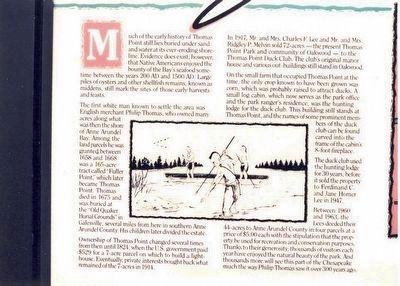
(Left side of the marker) Much of the early history of Thomas Point still lies buried under sand and water at its ever-eroding shoreline. Evidence does exist, however, that Native Americans enjoyed the bounty of the Bay’s seafood sometime between . . . — — Map (db m94344) HM
On Wayman Avenue, on the right when traveling south.
Designed by Frederick Douglass so that "As a free man I could look back across the bay to the land where I was born a slave". Built by Charles Remond Douglass. 1895 — — Map (db m6173) HM
On Elm Road east of West Nursery Road, on the right when traveling east.
The US Navy's AN/SPG-55 is a tracking/illumination radar for the beam riding Terrier and semi-active homing RIM-67 Standard missiles. It was a major component of the MK76 Fire Control System used in fleet and area protection. . . . — — Map (db m131629) HM
On West Nursery Road south of Elm Road, on the right when traveling north.
The Naval Research Laboratory developed and constructed the experimental XAF radar in 1938.
It was installed on the battleship USS New York for winter maneuvers in the Caribbean in early 1939. After nearly three months of constant . . . — — Map (db m131634) HM
On Chesapeake Bay Drive, 0.6 miles north of John Downs Loop, on the right when traveling north.
First established in 1822 (discontinued in 1855) the Bodkin Island Lighthouse would have been visible to your left in the distance. It has long since crumbled and what remains of the lighthouse and the island on which it stood now show only as a . . . — — Map (db m147648) HM
Near Bayside Beach Road, 2.3 miles east of Fort Smallwood Road (Maryland Route 173), on the right when traveling east.
On June 22-24, 1608, Captain John Smith and his small crew in an open boat explored the waters adjacent to Hancock's Resolution Park. This is proved by his mapping of the Magothy River, Bodkin Creek, and the Patapsco River (which he called the . . . — — Map (db m9279) HM
On Chesapeake Bay Drive, 0.4 miles north of John Downs Loop, on the right when traveling north.
During the period 1913 to 1937 this property was the summer estate of H.R. Mayo Thom. The bridge and bathhouse pictured here were used by family and friends for access to the beach. Catherine (Thom) Parsons recalls:
On Bayside Beach Road, 2.3 miles east of Fort Smallwood Road (Route 173), on the right when traveling east.
Bodkin Island, having an excellent view down the Bay, was an observation station long before the war. The "Bodkin Telegraphe", a flag-signalling system based on Baltimore's Federal Hill, alerted Baltimore merchants from here as their ships . . . — — Map (db m76732) HM
On Chesapeake Bay Drive, 0.1 miles north of John Downs Loop, on the right when traveling south.
During the period 1913 to 1937 this property was the summer estate of H.R. Mayo Thom. The gazebo pictured here was built and enjoyed by the Thoms during this period. Catherine (Thom) Parsons, daughter of H.R. Mayo Thom recalls: . . . — — Map (db m147649) HM
The Chesapeake Bay
About 35 million years ago a large meteor struck near what would eventually become the mouth of the Chesapeake Bay. The meteor forever altered the surrounding area.
10 to 2 million years ago, our planet went . . . — — Map (db m209203) HM
Near Chesapeake Bay Drive, 0.1 miles north of John Downs Loop, on the right when traveling north.
In 1913 this property belonged to a wealthy Baltimorean, Mr. H. R. Mayo Thom. He was the first person in Maryland to plant oysters on land leased from the state under the new Haman Oyster Culture Law. The Rocky Beach Oyster Farm was located . . . — — Map (db m147651) HM
Near Chesapeake Bay Drive, 0.6 miles north of John Downs Loop, on the right when traveling north.
During the period 1913 to 1937 this property was the summer estate of H. R. Mayo Thom. Mr. Thom was a wealthy Baltimorean who made many improvements to the property. This boat, the Tonkaway was once of his greatest pleasures Catherine (Thom) . . . — — Map (db m147647) HM
On East West Shady Side Road west of Bast Avenue, on the right when traveling north. Reported unreadable.
This magnificent sailboat inspired a frenzy of boat building on the West River. In the 1930s, the Vanity reigned supreme in the hotly-contested 20-foot open class, a free-for-all sailboat race where the only requirements were that boats be . . . — — Map (db m130029) HM
On East West Shady Side Road west of Bast Avenue, on the right when traveling north.
The story of the Captain Salem Avery House mirrors that of Shady Side and the larger history of the Chesapeake Bay region.
1860-1921 The Avery Family Home
In the mid-19th century, a young man came to Shady Side from New York to . . . — — Map (db m130026) HM
On East West Shady Side Road west of Bast Avenue, on the right when traveling north.
I drew it up, most of the time on a piece of plywood, so it wouldn't get wrinkled up, and I'd use the measurements from that. I always liked to build boats, and I like to change the style of them and try to get something to look pretty good. . . . — — Map (db m130019) HM
On East West Shady Side Road west of Bast Avenue, on the right when traveling north.
You just can't put your line in any place and get a crab. You got to know where they are. I could give some people my boat and line, but they'd starve to death. You have to have a feel for it.
— George Procter, age 83 . . . — — Map (db m130016) HM
On East West Shady Side Road west of Bast Avenue when traveling north.
I haven't seen 15 bushels of clams in so long... You do worse more days than you do better. Nature can't put it back as fast as man takes it away.
— Ellsworth Brown, clammer, age 55 (1977)
Eeling
Bay . . . — — Map (db m130006) HM
On East West Shady Side Road west of Bast Avenue, on the right when traveling north.
He had powerful arms, shoulders, and hands. Pulling and hauling on nets all of his life, his hands were huge. He was a waterman.
— Howard Shenton, age 67 (1986)
The Catch
Fishing has been a year-round . . . — — Map (db m130007) HM
On East West Shady Side Road west of Bast Avenue, on the right when traveling north.
When you got into Baltimore, you'd fall short maybe twenty-five, thirty bushel…'Cause they took a good round bushel, you know, out of it. And this is life, the way we lived it.
— Erwood Avery, Age 84 . . . — — Map (db m130018) HM
On East West Shady Side Road west of Bast Avenue, on the right when traveling north. Reported unreadable.
You'd be better off with a boat than you were with shoes.
— Erwood Aver, age 77 (1984)
In the past, rivers were the roads connecting the people and products of Shady Side with Baltimore, Annapolis and other villages . . . — — Map (db m130025) HM
On East West Shady Side Road west of Bast Avenue, on the right when traveling north.
Then I took up oystering, went on the water oystering, and, oh my, I stayed out there and worked, and worked, and worked.
— Julius Dennis, age 88 (1984)
Scooping and Raking — Tonging and Dredging
To . . . — — Map (db m130012) HM
On East West Shady Side Road west of Bast Avenue, on the right when traveling north.
A bad day on the water is better than the best day on land.
— J.R. Gross, age 32 (2000)
To make a living, a waterman thinks not in terms of weekly paychecks but rather, how much his family will bring in during the . . . — — Map (db m130004) HM
On East West Shady Side Road west of Bast Avenue, on the right when traveling north.
For tonging oysters —
the best built boat there ever was…
— Kenneth Nieman, age 72 (1984)
In 1933, a boathouse on Parrish Creek in Shady Side, Captain Perry Rogers built the deadrise on display for . . . — — Map (db m130020) HM
Near East West Shady Side Road west of Bast Avenue, on the right when traveling north.
Erosion has dramatically altered the waterfront you see — washing away more than 200 feet of land in Captain Avery's "front yard." It is said that the Avery family had to move the house back three times in the years they owned it. The original . . . — — Map (db m130022) HM
On East West Shady Side Road west of Bast Avenue, on the right when traveling north.
The Captain Avery Museum is a place to discover Chesapeake Bay life — past, present, and future. This property, first developed in the 1850's, has been continuously owned by the people connected to the water by occupation, recreational . . . — — Map (db m130001) HM
• Built in 1883 at the mouth of the Magothy River to mark the dangerous Sandy Point Shoal.
• A wood caisson foundation supports a 35 foot diameter x 32+1/2 foot high cement filled cast iron cylinder.
• The lighthouse is a 24 foot square, . . . — — Map (db m198194) HM
The marshlands you see around you play an integral part in keeping the Bay healthy. Besides acting as a nursery for fish, crabs, and other wildlife, marshes act as filters and sediment traps to protect the Bay's water quality. They also act as giant . . . — — Map (db m79983) HM
On Howard Street at Dolphin Street on Howard Street.
Charles Hazeltine Hammann Ens Air Service U.S. Navy March 16, 1892-June 14, 1919
Henry Gilbert Costin Pvt. Co. H, 115TH Inf., 29th Div June 15, 1898-October 8, 1918.
Ensign Hammann rescued a fellow pilot by landing his seaplane on a . . . — — Map (db m101516) WM
On West Lexington Street at North Eutaw Street, on the right when traveling west on West Lexington Street.
Seafood—especially varieties caught right in the Chesapeake Bay—has always been front and center at Lexington Market. For more than a hundred years (from 1820s to 1920s), there was a dedicated market shed building at Lexington devoted only to . . . — — Map (db m243490) HM
On O'Donnell Street. Reported permanently removed.
Captain John O’Donnell, the founder of the Canton Community, was a man of great vision and accomplishment. He initiated trade between Canton, China and Baltimore in 1785 operating his own merchant sailing vessels. This public square once the site . . . — — Map (db m184475) HM
After the United States declared its independence from Britain in 1778 the young nation’s navy, which had a small number of ships, was constantly being attacked by the British on the high seas. In response President George Washington directed . . . — — Map (db m180264) HM WM
On O’Donnell Street at Potomac Street, in the median on O’Donnell Street.
Through the efforts of the Canton Improvement Association this old and densely populated ethnic neighborhood was named to the National Register of Historic Places in 1978. The two-story red brick row houses are especially noteworthy for their hand . . . — — Map (db m184476) HM
Near Boston Street at Potomac Street, on the right when traveling east.
The Pennsylvania Railroad used this railroad transfer bridge to land cars that were transported on ferries between Locust Point and Canton. Known as "carfloating," this activity occurred in the Baltimore Harbor from 1871 to 1969. This two-story . . . — — Map (db m212895) HM
On Boston Street at South East Street, on the right when traveling east on Boston Street.
Capt. John O'Donnell, considered the founder of Canton, made his fortune trading in East Asia. Around 1875, he settled in the Canton area and named his plantation after the port city of Canton, China. Capt. O'Donnell became an enslaver, and the . . . — — Map (db m212897) HM
On Boston Street at South Potomac Street, on the right when traveling east on Boston Street.
Canton Cove is directly in front of you. Here, schooners would wait before receiving the message to head to Fells Point to unload their cargo. The Inner Harbor, at that time, was a swamp and not navigable.
Fort McHenry is further out to the . . . — — Map (db m245857) HM
On Baltimore Waterfont Promenade east of Boston Street, on the right when traveling east.
Harnessing the power of nature to help keep the Baltimore Harbor clean
The amazing machine you see before you uses a combination of old and new technology to harness the power of water and sunlight to pick up litter and debris flowing down . . . — — Map (db m212890) HM
On Boston Street west of South Lakewood Avenue, on the right when traveling east.
Harris Creek
The Harris Creek was once an above ground stream large enough to sail a ship in. It was filled in to make more land for development in the early 1800s. It is now completely piped underground, but it continues to run through . . . — — Map (db m212889) HM
On Boston Street just east of South Kenwood Street, on the right when traveling east.
Douglass escaped slavery with a bold plan, a clever disguise, steady nerves, and help from his friends.
At the age of 20, Frederick Bailey (as he was called) lived under slavery in Fell's Point, one mile west of this marker. He was . . . — — Map (db m212894) HM
Near Newgate Avenue, 0.4 miles east of Keith Avenue, on the left when traveling east.
S.S. John W. Brown
Built for
U.S. Maritime Commission
Hull No. 312
by
Bethlehem-Fairfield Shipyard, Inc.
Baltimore, Maryland
September 1942 — — Map (db m145656) HM WM
Near Newgate Ave, 0.4 miles east of Keith Ave., on the left when traveling east.
The only known remaining lifeboat from Savannah's original outfit of four lifeboats, No. 2 is a 26' long aluminum hull, oar-propelled open boat manufactured in 1959 by the Welin Davit and Boat Company of Perth Amboy, New Jersey. This . . . — — Map (db m145941) HM
Near Newgate Ave., 0.4 miles east of Keith Ave., on the left when traveling east.
This segment of the main reduction gear was donated to the N/S Savannah Association in 2009 by the Southern Scrap Company of New Orleans, Louisiana. It weighs about 37,500 lbs, or nearly half of the weight of the complete gear. Notice that the hub . . . — — Map (db m145942) HM
The Susquehannock and Algonquian Indians had long traveled through this area when Captain John Smith explored and mapped the Chesapeake Bay region in 1608. As the Susquehannocks went from Pennsylvania to the bay, they crossed the Gwynns Falls . . . — — Map (db m6390) HM
Near Washington Boulevard. Reported permanently removed.
After centuries of abuse, the Gwynns Falls is being restored as a healthy stream. Government, civic groups, and scientists monitor water quality here and work together to implement restoration projects. Volunteers pick up trash, plant trees and . . . — — Map (db m6389) HM
On Washington Boulevard (Alternate U.S. 1) south of Western Avenue, on the right when traveling south.
Metropolitan Baltimore is a human-dominated ecological system. The Baltimore Ecosystem Study (BES), part of the National Science Foundation's Long-Term Ecological Research Network, conducts research to understand how this system changes over . . . — — Map (db m220064)
On West Baltimore Street, on the right when traveling west.
The lofty, triple-arched Baltimore Street Bridge was built here in 1932 to provide better access across the Gwynns Falls Valley to the city's rapidly developing west side. Earlier, the Frederick Turnpike crossed farther south on a relatively . . . — — Map (db m6351) HM
Near Frederick Avenue (Maryland Route 144), on the right when traveling west.
The Ellicott Driveway portion of the Gwynns Falls trail follows the route of a millrace that carried water to a flour-milling complex owned by the Ellicott family. In the 1800s, 26 gristmills along the Gwynns Falls and other on the Jones Falls . . . — — Map (db m5533) HM
The Gwynns Falls Trail at Middle Branch Park is a splendid place to do some birdwatching, learn to row, try your luck fishing, and relax while enjoying views of the city’s skyline and harbor activities. To the north, under I-95, the Gwynns Falls . . . — — Map (db m65304) HM
On South Hanover Street (Maryland Route 2) south of Redbird Avenue, on the right when traveling north. Reported damaged.
Welcome to the Gwynns Falls Trail, Baltimore's Greenway to the Chesapeake Bay. From here the trail runs 15 miles through 2,000 acres of stream-valley parklands to the I-70 Park & Ride near historic Franklintown and alternatively through Solo . . . — — Map (db m212961) HM
On Water Street east of Commerce Street, on the left when traveling east.
Until the 1850's, Baltimore's grain trading took place in "counting rooms" of individual merchants or on Bowley's Wharf where an effort was made to standardize corn and grain prices by displaying grain samples on barrel heads and window ledges. . . . — — Map (db m127236) HM
On Buffalo Yard Road just south of African Journey, on the right when traveling north.
On June 23, 2000, the Treasure, a large iron-ore tanker, sank in rough waters off the coast of South Africa, dumping over 1,300 tons of oil and diesel fuel into the ocean. More African penguins were impacted by this oil spill than by any other in . . . — — Map (db m189063) HM
On Buffalo Yard Road just south of African Journey, on the right when traveling north.
Among the volunteers were two top African penguin experts from The Maryland Zoo who made the trip from Baltimore to Cape Town. Both had worked with African penguins for years, knew how to handle the birds, and were able to lead others especially . . . — — Map (db m189066) HM
On East Coast Greenway south of East Drive, on the right when traveling south.
Water flowed throughout Druid Hill Park for many years. Within a few years of the park's opening, over a dozen springs were adorned with statues and architectural features, many of which were designed by park architect, George Frederick. Benches . . . — — Map (db m212294) HM
On Buffalo Yard Road just south of African Journey, on the right.
The tremendous rescue operation was coordinated by SANCCOB (the Southern African Foundation for the Conservation of Coastal Birds). Staff and volunteers worked around the clock for weeks. They rescued and rehabilitated more . . . — — Map (db m189065) HM
Near Safari Place north of Beechwood Drive, on the right when traveling north.
In 2009, the Zoo's prairie dog colony moved from this location to their current home near the Zoo's Main Gate. Before there were prairie dogs here, though, there were sea lions.
The first sea lion in Druid Hill Park arrived in 1884 by train . . . — — Map (db m189042) HM
On Buffalo Yard Road just south of African Journey, on the right when traveling north.
Survival in the Wild
When fish are scarce, African penguins must keep on swimming.
There are not as many fish in the Benguela Current as there used to be, due in large part to years of unregulated commercial fishing. Food . . . — — Map (db m189062) HM
On Stony Run Walking Path at West Cold Spring Lane, on the right when traveling north on Stony Run Walking Path.
A Path to Healthier Streams
Take note of the next 200 feet of trail you're enjoying! This new section of Stony Run Path was designed for the benefit and enjoyment of our community and to help us restore our streams, the Baltimore Harbor, . . . — — Map (db m212248) HM
On William Street north of Warren Street, on the left when traveling north.
This property is listed on the National Register [of Historic Places]
as part of
Federal Hill
National Historic District
and is registered with the
Preservation Society — — Map (db m240365) HM
On Warren Street at Henry Street, on the right when traveling west on Warren Street.
Since the founding of Baltimore, 1729, this hill has been a popular point for viewing the city’s growth. Here 4,000 people feasted 1780, to celebrate the ratification by Maryland of the Federal Constitution and in honor of the new government gave . . . — — Map (db m2555) HM
On East Cross Street, on the right when traveling west.
In July 1846, a battered and storm-tossed hulk, the William Penn, was moored at the pier at Light Street wharf across from what is now the McCormick building. A ship chandler, a rigger and other local merchants with interests in the . . . — — Map (db m7076) HM
Near Thames Street south of Point Street, on the right when traveling east.
Lady Maryland is an authentic reproduction of a Chesapeake Bay pungy schooner. Beginning in the early 19th century, pungies were considered to be among the fastest of all Bay watercraft, and were frequently used to carry perishable . . . — — Map (db m219646) HM
Near Thames Street south of Point Street, on the left when traveling west.
Sigsbee is a Chesapeake Bay skipjack, a vessel designed and built specifically to dredge for oysters on the Bay. Once numbering in the thousands, only a handful of skipjacks survive today. Together, they constitute the last sailing . . . — — Map (db m219651) HM
For the past 300 years, wharfs have jutted into Baltimore harbor, and been home to commercial and residential buildings. What is known today as Chase’s Wharf, where you are standing, had long been a bustling site with one and two-story frame and . . . — — Map (db m103331) HM
On Thames Street south of Point Street, on the left when traveling south.
For the past 300 years, wharves have jutted into Baltimore's Harbor to accommodate commercical and residential buildings. The grounds where you stand have long been a bustling site with one and two-story frame and brick buildings dating . . . — — Map (db m219611) HM
On Thames Street at Bond Street, on the right when traveling west on Thames Street.
At this location, then known as the Union Hotel, a group of some 90 state licensed bay pilots met in the hotel lobby to form the Association of Maryland Pilots. Captain Henry Vaughan was elected as their first president. Several rooms of the second . . . — — Map (db m109877) HM
On Thames Street at Broadway, on the left when traveling east on Thames Street.
A colonial maritime community established 1726 by William Fell, shipbuilder of Lancashire, England. In this area were built more than six hundred ships from the colonial era through the Civil War. Birthplace of the U.S. Frigate “Constellation” and . . . — — Map (db m2517) HM
On Thames Street at South Broadway, on the right when traveling east on Thames Street. Reported damaged.
Fells Point
Baltimore's Original Deep Water PortFeisty, independent Fells Point was annexed by Baltimore in 1773. Despite the loss of its political independence, it has stayed true to its working class, maritime roots. Today, . . . — — Map (db m220780) HM
On Thames Street south of Point Street, on the left when traveling south.
Frederick Douglass is one of the best known Americans of the 19th century. Countless schools, churches, and other community buildings across the United States have been named after him. Known for his bravery, vision, and insightfulness, Douglass . . . — — Map (db m219626) HM
On Shakespeare Street just west of South Bethel Street, on the left when traveling west.
In memory of
Edward Fell
Maryland 1723 from Lancaster, England. Acquired land, Jonestown. Later part of Baltimore Town. Importer, died 1743.
William Fell
Brother of Edward. Maryland 1730. Married Sarah Bond 1732. Acquired thousand . . . — — Map (db m145477) HM
On South Central Avenue south of Lancaster Street, on the right when traveling north.
Our mission:
Living Classrooms Foundation is a nonprofit organization that strengthens communities and inspires people to achieve their potential through hands-on education and job training, using urban, natural, and maritime resources as . . . — — Map (db m219653) HM
On South Central Avenue just north of Dock Street, on the right when traveling north. Reported permanently removed.
This property was once known as City Dock, which was built in the early 1830s and used by ship and rail merchants. Living Classrooms Foundation, in partnership with Baltimore City, began to revitalize what is now the Living Classrooms East Harbor . . . — — Map (db m145577) HM
On South Bond Street at Thames Street on South Bond Street. Reported damaged.
A national heritage site, the Frederick Douglass-Isaac Myers Maritime Park celebrates African-American who worked on Baltimore’s maritime trades in the 1800s. It also tells the stories of Frederick Douglass and Isaac Myers, who worked as chandlers . . . — — Map (db m102951) HM
A “nest of pirates”—that’s what the British admiralty once dubbed Baltimore’s historic Fell’s Point, then one of the most important shipbuilding centers in the nation and the home port of courageous privateers who sailed speed . . . — — Map (db m61039) HM
On Thames Street east of Caroline Street, on the right when traveling east.
Michael Hankin's Vision
Baltimore is a better place thanks to Mike Hankin, a strong business and civic leader and fervent environmentalist. The environment he loves most is the Baltimore Harbor.
In 2005, he led the creation of the . . . — — Map (db m113110) HM
During the early 1800s, shipyards dotted Baltimore’s Harbor. Many of them drew vessels in need of repair from waters up and down the Atlantic coast. Repairs ranged from minor sail mendings to complicated restorative hull work rendered by skilled . . . — — Map (db m103411) HM
On Thames Street south of Point Street, on the left when traveling south.
During the early 1800s, shipyards dotted Baltimore's harbor, drawing vessels in need of repair from waters up and down the Atlantic coast. Skilled shipwrights and carpenters performed a range of repairs from minor sail mending to complicated . . . — — Map (db m219640) HM
The Living Classrooms Foundation is a non-profit organization, operates for the benefit of the community at large, providing hands-on education and job skills training to students from diverse backgrounds, with a special emphasis on serving at . . . — — Map (db m168864) HM
On Thames Street west of Point Street, on the right when traveling west.
The Maritime Park and Museum, one of many Living Classrooms Foundation facilities, opened in 2006 and uses our motto "Learning by Doing" to engage visitors through interactive displays, hands-on activities and special programs. The . . . — — Map (db m219599) HM
Near Thames Street south of Point Street, on the left when traveling south.
The Maritime Park and Museum, one of many Living Classrooms Foundation facilities, opened in 2006 and uses our motto "Learning by Doing" to engage visitors through interactive displays, hands-on activities and special programs. The . . . — — Map (db m219642) HM
Swimming pools and a basketball court were once located on the floodplain here along the Gwynns Falls. Now, trees stabilize the stream banks to help reduce erosion during periodic floods and restore the stream’s health. The basketball court was . . . — — Map (db m102624) HM
The two-mile portion of the trail between here and Trailhead 4 at Leon Day Park is the only section with a gravel surface. The trail follows the route of an early 1800s millrace along the Gwynns Falls that carried water from Dickeyville to power . . . — — Map (db m102658) HM
Here in Leakin Park wander around Winans Meadow, enjoy a picnic, and walk in a Piedmont forest and bike along the Dead Run as it flows to the Gwynns Falls and eventually the Chesapeake Bay. View ruins of old farm buildings, a mock fort, and an iron . . . — — Map (db m115236) HM
Forests cover almost 12 of the 65 square miles in the Gwynns Falls watershed.
To understand the forest, look for patterns such as tree types, indicator species, species richness, gaps, and evidence of fire.
Stratification is the pattern . . . — — Map (db m102680) HM
On Harford Road (Maryland Route 147) south of Parkside Drive, on the right when traveling north.
[Original inscription, since destroyed:]
Sacred to the Memory of Chris. Columbus
Octob. XII MDCCVIIIC
[1964 plaque, which remains on the memorial:]
Columbus Monument
Re-located from North Avenue, east of Harford Road . . . — — Map (db m226272) HM
On East Pratt Street at Commerce Street, on the right when traveling east on East Pratt Street.
Near this spot, the Baltimore steamer President Warfield began her epic voyage into history. Built in 1928 as the flagship of the Old Bay Line, she ran nightly cruises between Baltimore and Norfolk. In 1943 she was given to Britain under . . . — — Map (db m59809) HM
From its founding in 1729, Baltimore’s proximity to the Chesapeake Bay was the engine that drove commerce, trade and industry. The most inland port on the eastern seaboard, Baltimore boomed as a leading city, center of industrial innovation and . . . — — Map (db m102969) HM
In honor to the abiding memory of The father of the Argentine Navy Admiral Guillermo Brown On the banks of the Delaware where he started his maritime career. "Brave in combat, magnanimous in victory and audacious in his decisions"
Born in 1777 in . . . — — Map (db m6158) HM
It’s amazing how much has happened here since Captain John Smith traveled up the Patapsco while exploring the Chesapeake Bay in 1608. Since its founding in 1729, Baltimore has been the scene of some of American history’s great moments, among them . . . — — Map (db m79856) HM
On East Pratt Street, on the right when traveling east.
Proximity to the Chesapeake Bay has been the driving force in Baltimore's eminence in commerce and transportation. But the story of Baltimore's port is actually older than Baltimore itself. In 1706 - two decades before the founding of Baltimore - . . . — — Map (db m34845) HM
On Light Street (Maryland Route 2) at East Conway Street, on the right when traveling north on Light Street.
After crushing the Americans at Bladensburg and invading the Nation’s Capital, the British targeted Baltimore. If they could capture the city—the third largest in the United States and a commercial and shipbuilding hub—they could likely bring the . . . — — Map (db m79868) HM
The world’s only authentic sailing reproduction of an 1812-era Baltimore Clipper. Pride of Baltimore II is more than a spectacular ship---it is a living, working symbol of Baltimore’s maritime heritage. With her sharply raked masts, abundance of . . . — — Map (db m102955) HM WM
Near Light Street east of E Conway Street, on the left when traveling south.
Baltimore’s shipbuilding heritage dates back nearly 300 years. By the 1790s, Maryland led the nation in shipbuilding and Baltimore was the undisputed industry leader on the Chesapeake Bay.
Launched in 1854, U.S.S. Constellation is the . . . — — Map (db m224409) HM
The promenade you are standing on lies within a very special space called the Critical Area. The Critical Area is the 1000 foot strip (about three city blocks) bordering the entire Chesapeake Bay and its tributaries, including the Patapsco River . . . — — Map (db m102990) HM
On East Pratt Street just east of Market Place, on the right when traveling south. Reported permanently removed.
The US Coast Guard Cutter Taney is the last warship "afloat" today which saw action during the 7 December 1941 Japanese attack on Hawaii. Built at the Philadelphia Navy Yard in 1935-36, USCG Taney's active career spanned 50 years of . . . — — Map (db m183365) HM WM
Baltimore began as a humble waterfront village in 1729. It burst into prominence as America expanded westward, forging a role as a major trading and transportation center that linked the nation’s interior to the world. From a mere 25 wooden houses . . . — — Map (db m104058) HM
Baltimore’s industry and trade grew concurrently, a partnership that fueled the city’s tremendous 18th and 19th century growth. You are standing at the mouth of the Jones Falls, a river that flows through Baltimore into the Inner Harbor’s Patapsco . . . — — Map (db m115214) HM
Near East Pratt Street west of Light Street (Maryland Route 2), on the right when traveling east.
Hammock rails line the spar deck except for the bow and stern. Each morning, crew would "trice" up their hammocks, bring them up to the spar deck, then bend them into a "U" shape and stow them in these rails. Canvas covers were pulled over . . . — — Map (db m219682) HM
933 entries matched your criteria. Entries 101 through 200 are listed above. ⊲ Previous 100 — Next 100 ⊳