On Lincoln Highway (Ohio Route 66) just west of North Main Street (Ohio Route 66), on the left when traveling east.
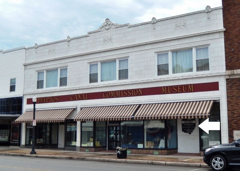
Delphos
Delphos began and flourished as separate settlements: East Bredeick, West Bredeick, Howard, and Section
Ten (named after a section of the canal). In 1851, Father John Otto Bredeick, a Bavarian priest who had purchased and founded this . . . — — Map (db m159752) HM
On East 2nd Street east of N Main Street, on the left when traveling east.
Sunday, December 7, 1941, "A date that will live in
infamy” without warning, at 7:55 a.m.. approximately
355 aircraft from the Japanese Imperial Navy
attacked the American military installations and
the naval base at Pearl Harbor on the . . . — — Map (db m196290) HM WM
On North Main Street at East 3rd Street, on the right when traveling north on North Main Street.
To the memory of all sailors who served aboard the destroyer
USS Frank E. Evans DD754
May we never forget the ship
the crews who proudly sailed her
and those who paid the ultimate price
while serving their country
Some Gave All . . . — — Map (db m196228) WM
On North Main Street at East Third Street, on the right when traveling north on North Main Street.
(logo of ship)
USS Texas (CGN 39)
The USS Texas (CGN 39) was built by the Newport News Shipbuilding and
Drtdock Company and was commissioned September 10, 1977
The ship had an overall length of 585’ with an extreme beam of 63’. A
crew of 575 . . . — — Map (db m94569) WM
On Lafayette Road, 0.1 miles north of Ada Road (Ohio Route 81), on the right when traveling north.
Following the American Revolution, the British Crown sought to retain possession of the Ohio Country by sending chief British Indian Agent Alexander McKee and others to establish trading posts with Native Americans and resist American settlement. In . . . — — Map (db m238374) HM
On Reservoir Road, 0.3 miles east of Metzger Road, on the right when traveling east.
Sacrifice
City of Lima
public water supply
Metzger Lake
Reservoir
Constructed 1946
Capacity 1200000.000 gals
Named in memory of
Lt. William E. Metzger, Jr.
Killed in action over Germany
November 9, 1944
Awarded . . . — — Map (db m173805) WM
Near Findlay Road (Ohio Route 81) 0.1 miles south of North McCullough Street, on the right when traveling east.
The Rotary Riverwalk/Ottawa River Bikeway has grown to become a vital link in the Lima-Allen County community.
Construction began in 1992 at Faurot Park in Lima and extended to Heritage Park in Shawnee Township. Lima continued the trail . . . — — Map (db m244699) HM
On North Broadway Street at East 3rd Street, on the left when traveling south on North Broadway Street.
This grain mill, which was located at the southwest corner of Second & Broadway Streets and considered one of the oldest landmarks in Spencerville, was constructed in 1843 and remained in existence until the early 1940's. The mill eliminated the . . . — — Map (db m196332) HM
On South Canal Street at West 1st Street, on the left when traveling south on South Canal Street.
Miami – Erie Canal
From 1845 to about 1906 barges pulled by horses provided transportation from the Ohio River to Lake Erie through a system of locks which raised or lowered boats to the next level of the canal.
Locks often became . . . — — Map (db m22933) HM
On Ohio Route 66, 0.2 miles north of Deep Cut Road, on the right when traveling south.
Miami & Erie Canal, Deep Cut
You are on that section of the Miami and Erie Canal where the greatest excavation was made – a section that has been known over the years as “Deep Cut.” The huge ditch, 6,600 feet long and 5 to . . . — — Map (db m22848) HM
On South Saint Marys Road (Ohio Route 66) 0.1 miles Deep Cut Road (County Road 226), on the right when traveling south.
Miami And Erie Canal Deep Cut
has been designated a
Registered National
Historic Landmark
Under the provisions of the
Historic Sites Act of August 21, 1975
this site possesses exceptional value
in commemorating or . . . — — Map (db m166567) HM
On S. Canal Street, on the right when traveling north.
From 1845 to about 1906 barges pulled by horses provided
transportation from the Ohio river to Lake Erie through a
system of locks which raised or lowered boats to the
next level of the canal.
Locks often became sites of towns. Beginning . . . — — Map (db m166569) HM
On South Broadway Street (Ohio Route 66) at East 3rd Street, on the right when traveling south on South Broadway Street.
Spencerville was platted in 1844 under the name "Spencer". In 1854, the name was changed to "Acadia", and was incorporated as Spencerville in 1866. The town was located on the banks of the Miami & Erie Canal, and its development as a commercial . . . — — Map (db m196325) HM
On South Broadway Street (Ohio Route 66) at East 3rd Street, on the right when traveling south on South Broadway Street.
Canal boats carried either freight or passengers. The typical canal boat was 14 1/2 feet wide by 85 feet long and carried up to 100 tons of cargo. Each boat typically had a captain, members of his family, animal drivers, steersmen and a bowman. The . . . — — Map (db m196328) HM
On North Broadway Street (Ohio Route 66) at East 3rd Street, on the left when traveling north on North Broadway Street.
Canal specifications called for the canal to be 28' wide at the bottom and 40' wide at the top. The water level was 4' deep and the tow path was 10' wide. A team of mules, donkeys or horses pulled the boat along by means of a 90 foot tow rope. — — Map (db m196329) HM
Near Miami-Erie Canal Walkway/Bike Path south of Zion Church Road, on the right when traveling south.
Uses along the canal have changed dramatically over time. The main use of the canal was the transporting of commerce. However, the canal ran through many towns and places where populations needed recreation and an outlet from everyday life. This . . . — — Map (db m236377) HM
Near Miami-Erie Canal Walkway/Bike Path south of Zion Church Road, on the right when traveling south.
Welcome to the Robert K. Antibus Trail Access
Dr. Robert "Bob" K. Antibus has faithfully served the citizens of Allen County as a commissioner for the Johnny Appleseed Metropolitan Park District since January of 1993. He is the longest . . . — — Map (db m236413) HM
On Miami-Erie Canal Walkway/Bike Path south of Zion Church Road, on the right when traveling south.
The Buckeye Trail and North Country Trails are located on the towpath of the Miami- Erie Canal, between the old canal and CR-66A, it then passes through Deep Cut Park, a 6,600 foot long, 50 foot deep, cut dug by hand. The Johnny Appleseed . . . — — Map (db m236414) HM
On Main Street (U.S. 250) just south of Center Road, on the right when traveling south.
James Lake is a 4 1/2 acre lake that drains an 85 acre
area west of the village. The water enters James Lake through
3 private lakes.
The lake was a gift to the village from the Don and Mary
Ringler family and is called James Lake in honor . . . — — Map (db m166365) HM
On Main Street (U.S. 250) just south of Center Street, on the right when traveling south.
The power for the light was provided from a home on the southwest corner of the lake. In 1958 the home was purchased by Earl and Eleanor Lemmel. The couple assumed responsibility for the electric bill and vowed to maintain it as long as they lived . . . — — Map (db m166366) HM
On Bridge Street (Ohio Route 531) west of Goodwill Drive, on the right when traveling west.
Built in 1889 by John & Oliver Topky
1889-1950
Topky Brothers Hardware & Ship Chandler
1951-1978
The Topky Hardware Company
1979-1995
Topky-Cook's Hardware Company — — Map (db m132356) HM
On Bridge Street (Ohio Route 531) west of Goodwill Drive, on the right when traveling east.
The location of Edward H. Burrill Meat Market, the Burrill Block was built in 1900
1900-1908
H. Bieder Company, confectioner, ice cream, cigars, news dealer
1909-1962
Christiansen Confectionery Store
Upstairs . . . — — Map (db m132364) HM
On Walnut Boulevard east of Hulbert Avenue, on the right when traveling east.
The "Bascule" Lift Brdige, a medieval term for draw bridge, works on the same counterweight system that raised and lowered drawbridges over moats that surrounded fortresses in the 15th and 16th centuries. In 1850, a pontoon bridge had been . . . — — Map (db m132369) HM
On Walnut Boulevard east of Hulbert Avenue, on the right when traveling east.
Where you are standing on this high bluff, overlooking the entrance to Ashtabula Harbor is referred to as Point Park. For almost two centuries, people have traveled here to observe the business activity of Ashtabula Harbor. This vantage point of the . . . — — Map (db m132374) HM
On Walnut Boulevard east of Hulbert Avenue, on the left when traveling east.
Restoration of the Air Funnel made possible through a donation by Robert (Bob) Halman in Memory of his wife, Sara Halman.
A ship's air funnel is used to send cool air from the ships upper deck to the lower levels of the ship. It can be . . . — — Map (db m132377) HM
On Bridge Street (Ohio Route 531) at Morton Drive, on the right when traveling west on Bridge Street.
More than 400 years ago, the Iroquois and Algonquin Native American tribes settled in the Ashtabula River basin, and named the river "Hash-tah-buh-lah"—"river of many fish."
The Ashtabula River became a shipping hub over the following . . . — — Map (db m132365) HM
Near Walnut Boulevard east of Hulbert Avenue, on the right when traveling east. Reported unreadable.
This Operator Station, "Bucket", and about 1/3 of the "Arm" were saved from one of the Ashtabula Huletts. Acquiring this was the idea of Joseph L. Rose. It was donated by the A & B Dock Company to the Maritime Museum. Only "18 foot" of the original . . . — — Map (db m132366) HM
On Walnut Boulevard east of Hulbert Avenue, on the left when traveling east.
In the summer of 2006, a "run away buoy" on Lake Erie washed up onto Walnut Beach in Ashtabula not far from our museum. Our Historian Ron McKinley received a call from city employee, Tony Tulino asking, "How would the museum like a . . . — — Map (db m132376) HM
On State Road South (County Road 25) 0.3 miles north of Plymouth Ridge Road, on the right when traveling west.
At one time, hundreds of covered bridges dotted the northeast Ohio countryside. A popular construction in 18th century Connecticut, the early settlers of the (Connecticut) Western Reserve brought this charming architecture with them from New . . . — — Map (db m213951) HM
On Harpersfield Road at State Road, on the left when traveling north on Harpersfield Road.
Replacing an earlier bridge that was carried away in a spring flood, the Harpersfield Covered Bridge was built in 1868 and spans the Grand River, a state-designated wild, and scenic river. This bridge, which currently carries County Road #154 . . . — — Map (db m121531) HM
On Richland Avenue just south of South Shafer Street, on the right when traveling south.
In tribute to Donald R. Johnson (1904-1973) who faithfully, devotedly and effectively served as secretary-treasurer of the Hocking Conservancy District
from its inception until the completion of the Athens Flood Protection Project (1972) of . . . — — Map (db m189702) HM
On Canal Street (U.S. 33) at Washington Street, on the left when traveling east on Canal Street.
This section of Route 33 in the City of Nelsonville is constructed on the site of the former Hocking Canal.
This early waterway, a tremendous factor in the industrial development of the Hocking Coal District of Ohio, was completed to this . . . — — Map (db m34217) HM
On Ohio Route 66 at County Route 182, on the left when traveling south on State Route 66.
During the canal years of the 1850's a rivalry grew between Bill Jones and Jack Billings for the love of Minnie Warren. This became hatred by Bill because Minnie chose Jack. On a fall night in 1854, returning from a party, Minnie and Jack were . . . — — Map (db m80159) HM
On Ohio Route 198, 0.2 miles south of Deep Cut Road (Local Highway 230), on the right when traveling north.
Along the River
Evidence suggests that General Wayne may have built a structure on
this site shortly after the Treaty of Greene Ville. A letter from Secretary
of State Thomas Pickering to the Committee of Military Establishments
in 1796 . . . — — Map (db m167041) HM
On West 4th Street west of North Frankfurt Street, on the right when traveling west.
Represents the strong Christian faith of the community. In the eighth century Charlemagne and Benedictine missionaries brought this faith to the Saxon tribes in the Munster and Osnabruck area of Germany.
Oak Leaf and Acorn - The acorn is . . . — — Map (db m238608) HM
On West 4th Street west of North Frankfort Street, on the right when traveling west.
This scene on Fourth Street, first known as Columbia Street, depicts the important business district of minster, circa 1900. People from the surrounding area would come to trade and shop in our many fine businesses. The construction of the Miami & . . . — — Map (db m238614) HM
On West 4th Street, on the right when traveling east.
Completed in 1845, the canal gave quick and easy access to the Ohio River and Lake Erie. Boats were towed along the canal using donkeys or horses, traveling at 4 to 5 miles per hour. With ice in the winter, flooding, and the slowness of the boats, . . . — — Map (db m238593) HM
On South Washington Street (Ohio Route 66) at East Front Street, on the right when traveling north on South Washington Street.
Located at a prime site during the peak canal days, this building was constructed as a residence circa 1848 and later sold in 1864 for an unheard of price at that time -- $3500. — — Map (db m157995) HM
Near East Front Street, 0 miles west of Washington Street (Ohio Route 66).
The Miami Erie Canal, built 1825-1845, 244.5 miles long, was a transporter of passengers and freight between Lake Erie and the Ohio River. This section is Loramie Summit., a 21 mile plateau of water retained by Lock 1-N (this marker) and Lock 1-S at . . . — — Map (db m22946) HM
On West Monroe Street (Ohio Route 247) at South Washington Street (Ohio Route 66), on the right when traveling east on West Monroe Street.
Locking Through
Lock One North is one of 105 locks used to raise and lower boats traveling between Lake Erie and the Ohio River. Large wooden gates were built at each end of the lock to hold water in the lock. A boat, pulled by a team of . . . — — Map (db m23062) HM
On West Monroe Street (Ohio Route 274) at South Washington Street (Ohio Route 66), on the right when traveling east on West Monroe Street.
Lockkeeper's House
The Lockkeeper's House was the residence of the Lockkeeper and his family. The Lockkeeper was on duty 24 hours a day, seven days per week, and was responsible for operating the lock as needed to move boats through the . . . — — Map (db m22781) HM
On South Washington Street (Ohio Route 66) 0.1 miles south of West Monroe Street (Ohio Route 274), on the left when traveling north.
The Miami and Erie Canal, connecting the Ohio River with
Lake Erie, was the primary mode of transportation for
cargo in the mid to late 1800s. This allowed towns like
New Bremen to quickly grow and prosper. Local farm
boys, leading the family . . . — — Map (db m167049) HM
On West Monroe Street (Ohio Route 274) at South Washington Street (Route 66), on the right when traveling east on West Monroe Street.
The Miami & Erie Canal and New Bremen
Begun in 1833, the Miami Extension linked the Miami Canal in Dayton to the Wabash & Erie Canal at Junction. Engineering difficulties, epidemics and the Panic of 1837 delayed completion of the Extension . . . — — Map (db m20023) HM
On South Water Street, on the right when traveling south.
These stones were originally used at Grand Lake St. Marys in the Bulkhead Lock constructed in 1852. Each stone was "neatly dressed with a bush hammer," meaning it was cut and finished with a hand chisel by masons at the construction site. . . . — — Map (db m236469) HM
On Lock 2 Road (County Road 70) east of Quelhorst Road, on the right when traveling east.
Welcome to the Kuenning-Dicke Natural Area
The Kuenning-Dicke Natural Area, located along the historic Miami and Erie Canal, between Lock One and the former site of Lock Two, offers 74 acres of wildlife protection and a peaceful site for . . . — — Map (db m238553) HM
On West Plum Street, on the right when traveling east.
The original "bump" bridge crossing the feeder was just a few feet above the water line of the canal. A canal boat actually bumped or pushed the bridge to turn the bridge decking to an open position. Then the bridge structure was a turntable on . . . — — Map (db m236459) HM
On County Road 168 at St Marys River Road, on the left when traveling west on County Road 168.
Broadwell Mill On this site a mill was constructed using a mill race for power. Destruction of the mill race by the 1913 flood ended operation. — — Map (db m98845) HM
The wicket gate displayed here is one of three gates manufactured by
St Marys Foundry, Inc.
for the Lock 13 rehabilitation project, completed in 2010. Two gates were installed in the bottom of the north lock doors to maintain hydraulic . . . — — Map (db m185607) HM
On East High Street west of North Chestnut Street, on the right when traveling west.
Established in 1823, the pioneer settlement of St. Marys became a thriving 19th century milling center following completion of the Miami & Erie Canal in 1845. The Reservoir Mill, built by Scott, Linzee & Co. in 1847, led this period of industrial . . . — — Map (db m185830) HM
Near East Spring Street (Ohio Route 29) west of South Chestnut Street, on the right when traveling east.
To the right is the Saint Marys River. This waterway was used by the Indians for generations as a route to hunting grounds in Kentucky. French, and later English traders traversed its course with trade goods in exchange for furs. James Girty, a . . . — — Map (db m30258) HM
Near Spring Street (Ohio Route 29) west of South Chestnut Street.
To the left is the "Short Level" of the Miami and Erie Canal. The canal extension from Dayton to Toledo was completed in 1837. Linking the Great Lakes to the Ohio River. Travel took only five days to Toledo and six days to Cincinnati. The canal . . . — — Map (db m29673) HM
Near East Spring Street (Ohio Route 29/66) east of Miami and Erie Canal Trail, on the right when traveling east.
The headwaters of the St. Marys River be just southeast of the City of St. Marys. The ever flows generally northwest to Wayne, Indiana, where it meets with the St. Joseph River in downtown ft. Wayne to form the Maumee River. The Maumee then flows . . . — — Map (db m228266) HM
“Transportation,” Murray seemed to be talking to himself, “transportation you gotta have. No use raisin’ a thousand bushels of wheat if you gotta carry it on your back two bushels at a time all the way to Dayton or Cincinnati to sell it. . . . — — Map (db m185606) HM
On Glynwood Road (County Road 160) east of Miami and Erie Canal Trail, on the right when traveling east.
Largest of 3 ponds created when the St. Mary's River was relocated here during construction of Miami-Erie Canal. The existing tow path is the west bank of the canal. Canal built Cincinnati to Toledo 1825 - 1845. — — Map (db m235858) HM
On Schillinger Road, on the left when traveling east.
The Miami and Erie Canal opened the western Ohio wilderness between Cincinnati and Toledo in the mid-19th century. More than 4000 workers labored to build the canal, earning 30 cents a day, a jigger of whiskey, and room and board. When completed, . . . — — Map (db m235857) HM
On Saint Marys Kossuth Road (Ohio Route 66) 1 mile south of Barber-Werner Rd..
Six Mile Creek Aqueduct. Canal aqueducts provide transportation of canal waters over natural waterways, allowing for reliable boat passage. The multi-arch masonry and formed concrete flume of the Six Mile Creek Aqueduct create a unique . . . — — Map (db m234184) HM
Grand Lake Saint Marys, originally Mercer County reservoir was worlds largest man made lake when constructed in 1837-1841 Water supply for Miami-erie Canal from here to the Maumee River at Defiance - 17603 acres. in 1856 lake level lowered 5.4 . . . — — Map (db m165762) HM
On Buckland- Holden road (County Route 190) 0.8 miles west of St Rt 117, on the right when traveling west.
On the headwaters of
the Auglaize River
The watershed of Three Rivers
originates within a
distance of 1/2 mile from this
point
West- Miami
East- Scioto
North-Auglaize — — Map (db m76609)
On Hardin county Road 15 (County Route 15) 1 mile north of St Rt 385 (Ohio Route 385), on the left when traveling north.
This is where the river starts and flowing southeast past Columbus, Circleville, and Chillicothe, joining the Ohio River at Portsmouth after a course of some 230 miles. — — Map (db m237211)
On Fair Street west of North Chestnut Street, on the right when traveling west.
Built For U.S. Maritime Commission Hull No.27 by Bethlehem-Fairfield Shipyard, Inc. Baltimore-Md.
Presented in memory of Capt. Clifford Howelle Barnesville — — Map (db m209545) HM
On Negus Road (County Route 456), on the right when traveling west.
A Quaker, he wielded great influence
in ship design during the
early years of our country
1794 clerk, United States War Department
1795- 1798 assistant Navy Constructor
1798- 1801 Navy Constructor and Superintendent of
Buildings, Gosport, . . . — — Map (db m89226) HM
Near Railroad Avenue, 0.2 miles south of Mellott Street.
On his journey down the Ohio River, Wednesday, October 24, 1770 noted in his diary "at the mouth of it (Captina Creek) we came abt 3 o'clock in the afternoon, and finding nobody there, we agreed to camp." Camped on return trip November 14 just above . . . — — Map (db m78500) HM
Near Mellot Street, 0.1 miles south of Main Street.
First surveyed in 1849, Powhatan Point was laid out by Franklin Knox. The "point" is the confluence of Captina Creek and the Ohio River. The small but thriving river and farming community served York Township and the rich Captina Valley as a . . . — — Map (db m78499) HM
On North Front Street south of Sycamore Street, on the right when traveling south.
Ripley was incorporated as the village of Staunton in 1812. Its name
was changed in 1816 to honor General Eleazer Wheelock Ripley, a hero
of the War of 1812. In the years before railroads. Ripley was
principal Ohio River shipping center. Also . . . — — Map (db m135431) HM
On North Front Street north of Main Street, on the left when traveling north.
A part of the Virginia Military District, Ripley was founded in 1812 by Colonel James Poage, a veteran of the Revolutionary War. Originally named Staunton, after Poage’s home town in Virginia, the village comprised 1,000 acres along the Ohio river. . . . — — Map (db m135427) HM
On Dixie Highway (Ohio Route 4) west of Holden Boulevard, on the right when traveling west.
For generations everyone from prince to pauper arrived in Cincinnati at the "public landing" along the banks of the Ohio River. "The Landing" as the local population knew it, greeted the new arrivals to the young city and still serves as a social . . . — — Map (db m201219) HM
On River Road at Lakeside Drive, on the right when traveling north on River Road.
Miami Chapel Cemetery. Around 1843, local Methodists organized a new Methodist Episcopal church at Fair Play and later erected a brick chapel. The congregation was short-lived, however, and fell into decline after one of its leading members, . . . — — Map (db m158422) HM
On High Street (Ohio Route 129/177) west of Monument Street, on the right when traveling east.
Mills were essential in the settlers' struggle to convert their land from a debt to an asset. Financial survival depended on access to grist mills, saw mills and carding mills - the trading complexes and community centers on the Ohio frontier. . . . — — Map (db m73595) HM
On High Street (Ohio Route 129/177) west of Monument Street, on the right when traveling east.
Because water was the most efficient way to transport goods, most early Ohio roads led to a navigable stream, such as the Great Miami River. Through the 1820s, much of Butler County's abundant agriculture output found its way to market on . . . — — Map (db m73593) HM
On High Street (Ohio Route 129/177) west of Monument Street, on the right when traveling east.
March 25, 1913, a record Great Miami River flood hit Hamilton, claiming more than 200 lives, leaving about 10,000 homeless and causing more than $10 million in property damage. Local survivors helped create the Miami Conservancy District - a . . . — — Map (db m73594) HM
On High Street (Ohio Route 129/177) west of Monument Street, on the right when traveling east.
Pierre-Joseph Celron, sieur de Bienville, with 200 to 250 French soldiers and some Indians, was sent in 1749 to renew and strengthen France's claim to the Ohio country and drive out the British. During navigation of the Allegheny, Ohio and Great . . . — — Map (db m73591) HM
On High Street (Ohio Route 129/177) west of Monument Street, on the left when traveling east.
The privately developed Hamilton Hydraulic opened Jan. 27, 1845, providing cheap, reliable water power and starting Hamilton's era of industrial growth and diversification. Water was diverted into the hydraulic canal system from the Great Miami . . . — — Map (db m73598) HM
On High Street (Ohio Route 129/177) west of Monument Street, on the left when traveling east.
The site for Fort Hamilton was chosen because of a ford on the Great Miami River at the approximate site of the High - Main Street Bridge. That shallow crossing was believed to have been on an ancient Indian trail known as the Wabash Trail. The . . . — — Map (db m73615) HM
On Ross Avenue at B Street, on the right when traveling south on Ross Avenue.
Rossville was settled in April 1801 shortly after the U.S. Government initiated land sales west of the Great Miami River. Its original proprietors--John Sutherland, Henry Brown, Jacob Burnet, James Smith and William Ruffin--named the town in honor . . . — — Map (db m28790) HM
Side A
The dimensions of the canal channel were 26 feet wide at the bottom and 40 feet wide at the top. The depth of the canal averaged four and one-half feet. The 12 locks were 80 feet long with 14-foot wide interior chambers which could . . . — — Map (db m122419) HM
On Central Avenue (Ohio Route 122) at N. Verity Parkway (Ohio Route 73), on the right when traveling west on Central Avenue.
Canal boats were designed to haul freight up to 80 tons. Pulled usually by mules, they traveled at approximately three miles per hour.
[Photos] Left, freighters on the Miami & Erie Canal just south of Third Street (now Central Avenue) in 1910. . . . — — Map (db m30422) HM
On Central Avenue (Ohio Route 122) at N. Verity Parkway (Ohio Route 73), on the right when traveling west on Central Avenue.
Canal locks were built to raise and lower boats as the elevation of the land changed. There were 106 locks on the Miami & Erie Canal to overcome a difference in elevation of 512 feet.
The Excello Lock, left, was the first lock completed on the . . . — — Map (db m30423) HM
On North Verity Parkway (Ohio Route 4) at Tytus Avenue, on the left when traveling north on North Verity Parkway.
At Middletown, Ohio, on July 21, 1825, ground was first
broken for the Miami-Erie Canal, which eventually
linked Cincinnati and Toledo. The canal created much
change in the region, including increased population
and commercial, political, and . . . — — Map (db m134879) HM
On Central Avenue (Ohio Route 122) at N. Verity Parkway (Ohio Route 73), on the right when traveling west on Central Avenue.
Canals were built in Ohio to provide a better way to transport goods to the eastern markets. Two major canals were built connecting the Ohio River to Lake Erie - the Ohio Erie & [sic Ohio & Erie] Canal running from Portsmouth to Cleveland and the . . . — — Map (db m30375) HM
On Central Avenue (Ohio Route 122) at N. Verity Parkway (Ohio Route 73), on the right when traveling west on Central Avenue.
Port Middletown, located at Third St. (Central Ave.), was the main port along the Miami & Erie Canal. A scale was located there and tolls were collected.
[Photos] Left, a fire in 1881 at the Ben Smith Livery at Port Middletown has just been . . . — — Map (db m30418) HM
On Verity Parkway (Ohio Route 4/73) at Main Street / Tytus Avenue, on the left when traveling north on Verity Parkway.
About 20,000 years ago this pink granite boulder was brought from Canada by the Wisconsin Glacier and deposited near here, along the Great Miami River. — — Map (db m29625) HM
On Verity Parkway (Ohio Route 4/73) at Yankee Road, on the left when traveling south on Verity Parkway.
In emulation of those who, July 21, 1825,
here began the building of the
Miami & Erie Canal,
this Ohio property was rededicated
November 2, 1929, to its original purpose -
transportation, with the confident hope
that a super-highway . . . — — Map (db m29665) HM
On Central Avenue (Ohio Route 122) at N. Verity Parkway (Ohio Route 73), on the right when traveling west on Central Avenue.
Ohio's canal system was the most effective between 1827 and 1850, before the introduction of the railroads. In Middletown, the canal was still used well into the 20th century but in 1913 a devastating flood destroyed much of the canal. In 1929 . . . — — Map (db m30430) HM
On Central Avenue (Ohio Route 122) at N. Verity Parkway (Ohio Route 73), on the right when traveling west on Central Avenue.
The lift bridge built in 1899 across the Miami & Erie Canal at Third Street (now Central Ave.), was the third bridge at this site since the canal began in 1825. An electric motor was used to raise the west portion of the floor of the bridge up the . . . — — Map (db m30431) HM
On Verity Parkway (Ohio Route 4 / 73) at Main Street, on the right when traveling north on Verity Parkway.
Verity Pkw. once Miami-Erie Canal
an Underground Railroad route
1830 - 1860
Those traveling along Underground
Railroad found safe stations
in N. Main St. homes of
African-Americans
listed on other side
Rice • Hawkins • Colston . . . — — Map (db m29667) HM
Edward Bebb, father of William Bebb and first Welshman to settle in Paddy's Run, Morgan Township, Butler County purchased this cabin in 1801. Originally the cabin stood four miles southeast of this site on the Dry Fork of the Whitewater River. It . . . — — Map (db m24001) HM
On Scio Road (Ohio Route 332) at Autumn Rd SW (County Road 19), on the left when traveling south on Scio Road.
The Algonquin Mill
was named for an Indian camp site near the settlement which is now Petersburg. This structure, built about 1826, replaced an earlier mill. Originally operated by water power from Little McQuire Creek, it drove two sets of burrs. . . . — — Map (db m159707) HM
650 entries matched your criteria. The first 100 are listed above. Next 100 ⊳