On 3rd Street Southwest west of Livestock Avenue, on the right when traveling east.
Camp SCS-4 (Huron): located on SE corner of State Fair Grounds. Companies: 2770--10/31/35-10/7/37; 4725V--10/7/37-8/15/41.
The Civilian Conservation Corps was a federal work - relief program during the Great Depression. From 1933 to 1942, . . . — — Map (db m179885) HM
On 4th Street NE (U.S. 14) at Jersey Avenue NE, on the right when traveling east on 4th Street NE.
While with the Bureau of Reclamation, Glenn Sloan saw the possibility of using mountain water from the Missouri River to develop irrigation in the James River Valley.
His vision and determination made possible the broadened multi-purpose . . . — — Map (db m123908) HM
On U.S. 18 at 230th Avenue (State Highway 73), on the right when traveling west on U.S. 18.
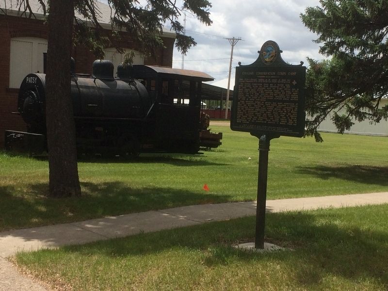
Camp BF-3: located 1 mile E, 4 miles S, 1 mile W & 5 miles S
Company: 4723 May 1937-Fall 1939
The Civilian Conservation Corps was a federal relief program during 1933-1942 that gave jobless men work renovating abused lands. The Army . . . — — Map (db m137082) HM
Near 24th Ave NE, 0.3 miles west of Roosevelt St N.
Dedicated to the memory of
Kent and Vera Baird
Prominent Residents of Aberdeen from 1925 - 1980
This portion of the Baird farm was donated by Roger, Virginia and Howard Baird in 2001 to the citizens of Aberdeen for their use as a park . . . — — Map (db m112670) HM
Founded on N S T C Campus
1940
(American Legion Logo)
Charles Dalthorp Ivan Huntsinger
Dr. Harry R. Darling Judge Harry E. Mundt
N. Peter Wenge — — Map (db m114786) HM
This 108-foot tower was built by the Civilian Conservation corps in 1936. The Sand Lake CCC camp ran from 1925 through 1939 and housed several hundred men. They built many of the dikes, fences, and facilities you see on the Refuge today. The . . . — — Map (db m103080) HM
On 112th Street (State Highway 10) 1.3 miles west of 400th Ave., on the right when traveling east.
Camp BF-2 (Sand Lake): 2 1/2 miles W and 2 1/2 miles S at headquarters. Company: 2749--6/28/35 - 7/31/39.
The Civilian Conservation Corps was a federal work-relief program during the Great Depression. From 1933 to 1942, the CCC provided work . . . — — Map (db m100979) HM
Near 5th Avenue (CanAm Highway) (U.S. 85) just north of Faulk Street, on the right when traveling north.
[marker on south side of cabin] This cabin, built in 1876 of logs split & transported by Spaulding from the Black Hills, was the first home on the Redwater & what became Butte County. An experienced scout, familiar with the . . . — — Map (db m234772) HM
On 382nd Avenue, 0.2 miles south of State Highway 50, on the right when traveling south.
Camp BF-1 (DSE-204): located in edge of town of Lake Andes
Companies: Nebraskans?--July-October 1933; 2759V -- 7/31/34-11/1/34; 2743 (Nebraskans) -- 5/25/35-Fall 1935
The Civilian Conservation Corps was a federal relief program during . . . — — Map (db m187634) HM
On 1st Avenue Northwest east of 3rd Street Northwest, on the left when traveling east.
Watertown's first city hall provided ground-floor space for the fire department and large, arched doors for its "trucks," which included a horse-drawn wagon with a thousand feet of hose and two hand-drawn ladder wagons.
Fire protection, rather . . . — — Map (db m245305) HM
On State Highway 87, 0.5 miles north of Lame Johnny Road, on the left when traveling north.
Camp SP-3 (DSP-1 in 1934): NE 2 miles, end of CSP road on French Creek. Company: 2757 - 7/28/34-10/1/41.
The Civilian Conservation Corps was a federal work-relief program during the Great Depression. From 1933 to 1942, the CCC provided work for . . . — — Map (db m124589) HM
Near South Playhouse Road east of Needles Highway (State Highway 87).
Camp SP-4 (DSP-2):
Lodge: located in the buildings seen here.
Companies:
2755–7/16/34 - 10/21/35 795–10/29/35 - 1/13/36 1793–4/27/36 - 7/30/42
The Civilian Conservation Corps was a federal relief program during
1933 - 1942 gave jobless . . . — — Map (db m203658) HM
On Mt. Rushmore Road (U.S. 16) at Lightning Creek Road (Forest Road 288), on the right when traveling west on Mt. Rushmore Road.
Camp F-14 Lightning Creek: located 0.7 mile NW on road 288. Companies: 1783V--10/17/33-Spring 34 791--4/30/34-Fall 41
The Civilian Conservation Corps was a federal relief program during 1933-1942 that gave jobless men work renovating abused . . . — — Map (db m185227) HM
Near Mount Coolidge Lookout Road near State Highway 87.
Found throughout the mountain west and perched high atop mountains, these manned towers
provide an excellent vantage point for spotting smoke columns and fires.
In Custer State Park fire detection
is a vital tool. The park's fire tower, Mount . . . — — Map (db m204234) HM
On Stockade Lake Drive, 1 mile east of Lower French Creek Road, on the left when traveling east.
Originally Constructed by the
Civilian Conservation Corps (CCC)
Completed in April 1937
South Dakota National Guard
Completed in August 1988
The Bridge is 76 feet, 4 inches long and 26 feet wide. Three spans, each constructed of 10 . . . — — Map (db m121402) HM
On Hearst Memorial Highway (U.S. 385) at Avenue of the Chiefs, on the right when traveling north on Hearst Memorial Highway.
George Hearst (1820-1891) United States Senator, mining engineer, sportsman, speculator. Starting with nothing, he developed three of the fabled mines in the American West -- The Ophir, the Anaconda, and the Homestake -- and founded one of the . . . — — Map (db m180982) HM
On U.S. 385, 1.9 miles north of 7-11 Road (County Road 101), on the right when traveling north.
Camp NP-1 (DNP-1): located southeast of the cave entrance
in Wind Cave Canyon.
Companies: 2754 -- 7/16/34 - 11/1/39
2757 detachment -- 4/18/40 - 8/1/40
The Civilian Conservation Corps was a federal relief program during 1933-1942 that . . . — — Map (db m134564) HM
He laid the foundation of the National Park Service, defining and establishing the policies under which its areas shall be developed and conserved unimpaired for future generations. There will never come an end to the good that he has done. — — Map (db m234600) HM
The Civilian Conservation Corps established a camp here during the Great Depression of the 1930s to make improvements to the park. This camp employed 200 men at a time and provided much needed jobs and training. Over an eight-year period, the young . . . — — Map (db m70977) HM
On U.S. 385, 1 mile north of State Highway 87, on the right when traveling north.
The valley in front of you is the site of the Wind Cave National Game Preserve, which was established in 1912 to reintroduce bison to the area. About 4,000 acres were enclosed to receive 20 bison from the New York Zoological Society and Yellowstone . . . — — Map (db m234681) HM
Fire towers like this were once erected all across the country to help spot wildfires before they got out of control. This tower is 110 feet tall with 133 steps to the top-not for the faint of heart!
Into the Trees
As you climb to . . . — — Map (db m125278) HM
Waubay National Wildlife Refuge is in the Prairie Pothole Region-a region of the northern Great Plains where shallow wetlands, or potholes, are scattered about the prairie. About 10,000 years ago, glaciers scoured the landscape and gouged out . . . — — Map (db m125281) HM
In 1935, when Waubay National Wildlife Refuge (NWR) was established, the country was in the midst of the Great Depression and a severe drought. President Franklin D. Roosevelt attacked the loss of jobs and the threat to natural resources by . . . — — Map (db m125277) HM
From hunting club to Refuge
What was once a hunting camp is now a refuge for waterfowl and other migratory birds. Waubay National Wildlife Refuge (NWR) was established in 1935 by President Franklin D. Roosevelt in response to record low . . . — — Map (db m125350) HM
From hunting club to Refuge
What was once a hunting camp is now a refuge for waterfowl and other migratory birds. Waubay National Wildlife Refuge (NWR) was established in 1935 by President Franklin D. Roosevelt in response to record low . . . — — Map (db m125355) HM
Saving ducks by saving stamps
To help restore waterfowl populations that had been wiped out by hunting and drought, Congress passed the migratory Bird Hunting Stamp Act in 1934. Under the Act, hunters purchase an annual Federal Duck . . . — — Map (db m125353) HM
On 192nd Street (State Highway 28) near North Lake Drive, on the right when traveling west.
The Civilian Conservation Corps was a federal relief program during 1933-1942 that gave jobless men work renovating abused lands. The Army built 48
200-man camps in South Dakota and provided
food, clothing, medical care,
pay and programs . . . — — Map (db m202576) HM
On East 5th Street east of North Broadway (U.S. 14), on the right when traveling west.
Harlan J. Bushfield, born August 6, 1882 in Atlantic, Iowa, came to Miller in 1883. He earned his law degree from the University of Minnesota in 1904 and returned to Miller to practice law. In 1912, Bushfield married Vera Cahalan, a fellow Miller . . . — — Map (db m185466) HM
The CCC built the Boy Scout Cabin in circa 1936 after the construction of the Girl Scout Cabin. While the Girl Scouts sponsored the construction of their cabin, it is unknown whether the Boy Scouts sponsored or helped in the construction of their . . . — — Map (db m225036) HM
Camp S-207 was established in 1933. The first men stationed here was an African Americans company from Kansas City, Missouri. Many townspeople were afraid of the African Americans, causing the local politicians to get them transferred. They were . . . — — Map (db m225041) HM
Times were tough in 1932, when President Franklin D. Roosevelt established the "New Deal" to help people find work so they could afford food and housing. Within two years, almost 40 percent of the people in the state were in one of these programs, . . . — — Map (db m225037) HM
On State Highway 34 at milepost 214 at Whitetail Avenue, on the right when traveling east on State Highway 34.
Camp S-207 (SE-207 in 1933): ¼ mile W and 2 miles S on Farm Island Companies: Number unknown -- (Blacks) 06/27/33 - 10/22/33; 796 -- (North Dakotans) 10/23/33 - 11/01/34; 2756 -- 10/20/34 - 09/30/37.
The Civilian Conservation Corps was a . . . — — Map (db m220042) HM
Near Farm Island Road, 1 mile south of South Dakota Highway 34, on the right when traveling south.
The CCC camp was established on this island during the summer of 1933 and provided work for 250 men. Work project plans were twofold: to convert Farm Island into a state recreation area and to build an 850-foot causeway between the northwest point . . . — — Map (db m225030) HM
On North Euclid Avenue (U.S. 83) south of East Prospect Avenue, on the left when traveling north.
Hughes County Courthouse (marker side 1)
The Hughes County Courthouse was built and occupied in February 1935, to replace the original 1883 brick structure. The new Courthouse was designed by architects Hugill and Blatherwick of Sioux . . . — — Map (db m124269) HM
On West Oak Street at West Broadway Avenue, on the right when traveling west on West Oak Street.
This rock weighing 14,700 pounds serves as a
memorial to the Mateer Family. The triangle
property upon which it rests was given to the
City of Pierre by Curtis B. and Verna S. Mateer
on March 3, 1964. They later completed it with
sod, . . . — — Map (db m169227) HM
Near Farm Island Road, 1 mile south of South Dakota Highway 34, on the right when traveling south.
The State Division of Forestry supervised CCC men at the Farm Island camp. These hardworking men:
• Developed Farm Island Recreation Area
• Erected the Lewis and Clark monument (not accessible due to high water)
• Built the Arikara . . . — — Map (db m225032) HM
On State Highway 240, 0.9 miles south of Interstate 90, on the right when traveling south.
Camps NP-2: 8 miles S of Wall on SD 240, 13 miles W (1 mile W of Sage Creek); and NP-3: 3/4 mile S. of Cedar Pass Visitor Center. Company: 2754 (NP-2) -- 11/1/39 - 10/24/41; (NP-3) -- 10/24/41 - 3/25/42. The Civilian Conservation Corps was a . . . — — Map (db m45287) HM
On 2nd Street Southwest, 0.1 miles east of Dakota Avenue South, on the right when traveling west.
The Field House was built by the W.P.A. in 1936. The government formed the W.P.A. (Works Progress Administration) to create jobs during the Great Depression. Native stone was hauled from local fields to keep the costs down. The building features a . . . — — Map (db m180706) HM
On U.S. 385 at Galena Road (Forest Road 534), on the right when traveling north on U.S. 385.
Camp F-20 Park Creek: located 3 mi E on FH 534;
2.75 mi N on FH 180; W of creek
Companies: 2759V – 11/2/34-7/30/41; 792 – 10/11/41-12/14/41
The Civilian Conservation Corps was a federal relief program during 1933-1942 that gave . . . — — Map (db m124592) HM
On U.S. 385 at Roubaix Lake Road, on the right when traveling south on U.S. 385.
Camp F-6 (Roubaix): 100 yards N of Lake entrance: W of road. Companies: 792--6/3/33-5/15/35: 10/18/35 6/1/40; 10/1/40-10/11/41; 2759V-(Detachment from Park Creek)--5/15/35-10/18/35.
The Civilian Conservation Corps was a federal work-relief . . . — — Map (db m185223) HM
On Main Street (U.S. 85) at McKinley Street, on the left when traveling south on Main Street.
In 1910, the Boy Scouts of America (BSA) was organized in the United States
utilizing the teachings of Sir Robert S.S. Baden-Powell of England. Within
of its founding in America, BSA troops were organized in the
northern Black Hills. From its . . . — — Map (db m183240) HM
On Williams Street at Denver Avenue, on the right when traveling north on Williams Street.
Andrew Carnegie, steel tycoon and philanthropist, is best known for his charitable contributions in financing public libraries. From 1886 until his death in 1919, Carnegie supported the construction of 1,679 public libraries across the United . . . — — Map (db m121064) HM
Near Pine Street near Sherman Street (CanAm Highway) (U.S. 85), on the right when traveling west.
Constructed by Boxelder Civilian Conservation Center 1967 U.S. Department of Agriculture Forest Service in cooperation with Office of Economic Opportunity — — Map (db m234697) HM
Near Charles Street (CanAm Highway) (U.S. 85) at Stewart Street, on the right when traveling south.
Deadwood's viewshed is an integral component that truly makes this community unique to the visitors who come here annually. Poised in the center of the downtown core district is McGovern Hill, an erosional feature carved by Whitewood and Deadwood . . . — — Map (db m234699) HM
On Charles Street (U.S. 85) at Stewart Street, on the left when traveling south on Charles Street.
On October 27, 1937, a group of twenty-one business and professional men gathered at the Franklin Hotel and
organized the Deadwood Rotary Club. According to the local newspaper, the new Rotary Club would
“…unite Deadwood with more than . . . — — Map (db m183429) HM
On Williams Street just north of Shine Street, on the right when traveling north.
In 1877, the first organized Episcopal services were held at the Langrishe Theatre in the mining camp of Deadwood City. From this humble beginning, a determined congregation of men and women established the Protestant Episcopal Society of Deadwood . . . — — Map (db m234771) HM
On West Main Street (CanAm Highway) (U.S. 85) at Alert Street, on the right when traveling east on West Main Street (CanAm Highway).
Lead's earliest city hall was located in the old business district, an area that was eventually lost due to ground subsidence. A new City Hall had then been constructed in 1912 on the corner of Main and Siever Streets and served the community until . . . — — Map (db m121499) HM
On U.S. 14A north of Roughlock Falls Road (County Highway 222), on the right when traveling north.
Camp F-18 Savoy: located 2 mi W on FH222 at Rod & Gun Camp
Companies: 756 -- 5/2/34 -10/15/34;
792 -- 5/15/35 - 10/17/35;
792 -- October 1940 - July 1941; summer 1941?
The Civilian Conservation Corps was a federal relief program during . . . — — Map (db m111548) HM
On Nemo Road at Merritt Estes Road (County Road 208), on the right when traveling south on Nemo Road.
Camp F-3 (Este): Located 1/2 mile west astride Estes Creek.
Companies: 789 - - 5/18 - 7/30/41
2759V - - (WWI Vets) 7/30/41 - 7/28/42
The Civilian Conservation Corps was a federal relief program during 1933-1942 that gave jobless men . . . — — Map (db m184412) HM
On U.S. 85 at Polo Loop, on the right when traveling north on U.S. 85.
In 1940, fourteen South Dakota chapters of the Daughters of the
American Revolution (DAR) contributed funds for the planting of
18.000 Ponderosa "Penny Pines" in a 25 acre tract along the west
side of Highway 85, about 4 1/2 miles from Deadwood . . . — — Map (db m184013) HM
Near I-90 (Interstate I-90) 5.6 miles US 83 (U.S. 83), on the right when traveling east.
Camp SCS-2 (DPE-22 in 1934): in city park at SW corner of Presho. Companies: 2756—8/1/34-10/20/34; 758—5/29/35-10/25/35; 2737—4/3-/36-10/15/36; 4726—5/15/38-10-15-38; 2770 detachment from Huron—late 1935 and early 1936.
The Civilian . . . — — Map (db m184640) HM
On 434th Ave., 1.5 miles 118th Stret when traveling north.
In 1996, with Executive Order 96-06, South Dakota Governor William J. "Bill" Janklow created the Governor's Commission on Fort Sisseton. His action ensured that input from dedicated local individuals, with a knowledge of history and a passion . . . — — Map (db m103085) HM
Curt Jones loved history for a lot of reasons. He saw history as a collection of great stories that can be told and retold. He saw history as a book of lessons to be learned. Most of all, he saw history as an experience that you can keep only if . . . — — Map (db m103086) HM
On South Dakota Route 34 at Custer Avenue, on the left when traveling east on State Route 34.
Camps D-Army-1 & SCS-6 (Fechner): 1/2 mile S on W edge of Ft. Meade D-Army-1 company: 2758--7/20/34-10/31/35. SCS-6 companies: 2765--10/15/36-5/27/42; 4725V--5/28/42-7/27/42. The Civilian Conservation Corps was a federal work-relief program during . . . — — Map (db m184004) HM
On 233rd Street (State Highway 34) west of South Maple Street, on the right when traveling west.
(side 1)
The Howard Public Library was the first public library chartered in Dakota Territory. Charter No. 1 was issued to the Ladies Library Association of Howard on January 8, 1886, by M.L. McCormick, Territorial Secretary. In 1889, the . . . — — Map (db m124599) HM
Side 1 The Reconstruction Finance Corporation (RFC) granted a $410,000 relief loan to South Dakota in 1932, the third year of the Great Depression, Garretson became one of five towns in the county allotted funds.
Its City Council then . . . — — Map (db m188833) HM
Near South Cliff Avenue, 0.2 miles south of East 41st Street, on the right when traveling south.
After a strong coalition of civic organizations urged the city to build Falls Park and to set up a City Specification Committee within the Chamber of Commerce, such a study was conducted in 1967-68. The subsequent transformation of the appearance . . . — — Map (db m197452) HM
On West 22nd Street, on the left when traveling west.
Side A
During most of the 19th century, few women completed high school
and only daughters of the privileged or well educated had an
opportunity for a higher education. In 1881 seventeen women met
in Boston, Massachusetts, to discuss . . . — — Map (db m97577) HM
On East 10th Street (State Highway 42) at South Van Eps Avenue, on the right when traveling east on East 10th Street.
Here stood the landmark Children's Home Society of South Dakota (CHS) "house of stone" orphanage, erected in 1901. Designed by Wallace Dow.
CHS began in 1893, operating out of a rented house in central Sioux Falls, as co-founders William and . . . — — Map (db m208676) HM
On South Kiwanis Avenue, 0.1 miles south of West 16th Street, on the right when traveling south.
So named by the City of Sioux Falls on June 13, 1932
On May 4, 1932 Kiwanis Club members planted 70 trees along Harvard Ave., one for each club member, from 18th St. north.
In response to this and at the suggestion of Ed Smith, the City . . . — — Map (db m244810) HM
On South Western Avenue south of West 15th Street, on the right when traveling south.
The Little Flower orphanage for Catholic children opened at Turton, S.D. in 1924. Eight years later an attic fire raged out of control and destroyed the home. Over the next few years, the more than 60 homeless children were shuttled to makeshift . . . — — Map (db m207156) HM
On Sunday July 11, 1920, at McKennan Park, several thousand people attended the first concert of the Sioux Falls Municipal Band. A year earlier, in the first city election allowing women to vote, citizens approved a proposal to support a city . . . — — Map (db m113433) HM
On South Western Avenue south of West 51st Street, on the right when traveling north.
Beginning in 1945 several proactive Sioux Falls women sought to dispel a widely held opinion: if a child were mentally impaired and unable to attend a public school, it was a hopeless task to try to train the child to live a useful life. Dorothy . . . — — Map (db m194777) HM
On South Spring Avenue at West 9th street, on the left when traveling north on South Spring Avenue.
In 1911, Sioux Falls had no public rest rooms or rest areas for women visiting the city or employed in local businesses. Recognizing the need, Edith Kellar Lillibridge and Anna M. Eddy assembled 30 women to organize the Woman's Alliance as a . . . — — Map (db m194692) HM
On South Minnesota Avenue at West 9th Street, on the right when traveling north on South Minnesota Avenue.
A frontier town such as Sioux Falls, Dakota Territory, built almost entirely of wood and surrounded by highly flammable prairie grass could be swiftly consumed by uncontrolled fire. Without protection, farms and towns were vulnerable . . . — — Map (db m184701) HM
On South Phillips Avenue at West 10th Street (State Highway 42), on the right when traveling south on South Phillips Avenue.
This plaque is dedicated to an outstanding pioneer woman whose efforts helped to develop the religious, educational, civic, and cultural life of the community.
Dr. Josiah L. Phillips brought his wife Hattie to abandoned Fort Dakota in 1870, . . . — — Map (db m192243) HM
On South River Road at East 10th Street (State Highway 42), on the right when traveling north on South River Road.
Where We've Been
On February 23, 1905, the first Rotary Club was formed when Paul P. Harris called together a meeting of three business friends and acquaintances in downtown Chicago, Illinois. Also attending the meeting were Gustave Loehr, . . . — — Map (db m192104) HM
The Harney Peak fire lookout, dam
and pumphouse were built by the
CCC in 1939 and are listed in the
National Register of Historic
Places. Harney Peak Elevation is
2207 meters (7242 ft). The peak is
the highest point east of the . . . — — Map (db m125087) HM
On East Main Street (U.S. 385) 0.4 miles north of Museum Drive, on the left when traveling north.
This memorial dedicated to
the young men of the
Civilian Conservation Corps
1933-1942
Made possible by a grant from
”Sarge”
Melvin B. Hermanson
2008 — — Map (db m120159) HM
On U.S. 385 at Horse Creek Road, on the right when traveling south on U.S. 385.
Camp F-2 (DF-2) Horse Creek: Located 2 miles W on Horse Creek. Companies: 791--5/22/33-4/30/34 2752--7/30/34-10/21/35 2761--10/25/35-01/36 2748--01/36-5/25/36
The Civilian Conservation Corps was a federal relief program during 1933-1942 that . . . — — Map (db m184419) HM
On Deerfield Road at East Slate Road, on the right when traveling east on Deerfield Road.
Camp F-15 Tigerville: Located 1/4 mile S of here.
Companies: 765--10/26/33-Spring 1934 757--4/21/34-10/20/34
2748--10/21/34-1/36 793--5/25/36-6/13/39
The Civilian Conservation Corps was a federal relief program during 1933-1942 that . . . — — Map (db m184461) HM
Near Deerfield Road, 3.2 miles north of Main Street (U.S. 385), on the right when traveling north.
This F-9 Hill City Civilian Conservation Corps CCC) Camp was established in March 1933. Congress began the program to address severe unemployment and poverty during the Great Depression and later terminated it in 1942, during World War II. The CCC . . . — — Map (db m155899) HM
On U.S. 385, 0.1 miles north of Custer Gulch Road, on the right when traveling south.
Camp F-4: Pactola Campsite inundated by Lake Pactola. Companies: 1789--6/8/33-10/35 2748--5/25/36-1940
The Civilian Conservation Corps was a federal relief program during 1933-1942 that gave jobless men work renovating abused lands. The Army . . . — — Map (db m184423) HM
On Tigerville-Mystic Road, 0.8 miles north of County Road 242, on the right when traveling south.
Camp F-1 Mystic: Located at this spot
Companies: 760--6/29/33-10/20/34 2753--10/20/34-10/30/35
2763--10/30/35-1/20/36 1790--1/20/36-1/6/38
The Civilian Conservation Corps was a federal relief program during 1933-1942 that gave jobless . . . — — Map (db m184462) HM
Near West Omaha Street just east of Canal Street, on the right when traveling west.
Dr. Valentine McGillycuddy with his wife Fannie, at home at 727 South St. McGillycuddy was Mayor, Indian Agent, Dean of the School of Mines and South Dakota's first State Surgeon.
Joseph and Alice Gossage
Publishers of the city's most . . . — — Map (db m187540) HM
Petrified wood is actually a fossil. and these are estimated to be 20-30
million years old.
The petrification process can take very little time under the right circumstances but the longer the process is given, the harder the rocks will . . . — — Map (db m231496) HM
Northville Water System
Built By
City of Northville
and
Work Projects
Administration
WPA Project Number 3809
Nineteen Thirty Nine — — Map (db m136328) HM
On East 7th Street east of South Main Street, on the right when traveling east.
This park has been given to the children of Winner by George C. "Shorty" McDonald.
He left two-fifths of his estate ($8,000) to the community to build a park for the children. McDonald was 68 years old when he died Jan. 1948. He was orphaned in . . . — — Map (db m234976) HM
On 450th Avenue, 0.4 miles north of 279th Street, on the right when traveling south.
Before Social Security, old age assistance, and other social safety nets, poor farms throughout the United States provided a place for those suffering through desperate times. The Turner County Poor Farm housed primarily aged and disabled men, . . . — — Map (db m183492) HM
On 479th Avenue (State Highway 11) at 301st St, on the right when traveling north on 479th Avenue.
Camp SCS-3 (DPE-211 in 1934): located in city park of NE Alcester. Companies: 2746--8/3-10/1/34 & 6/27/35-8/14/41; 4725V--8/15/41 - 5/27/42.
The Civilian Conservation Corps was a federal work - relief program during the Great Depression. . . . — — Map (db m190163) HM