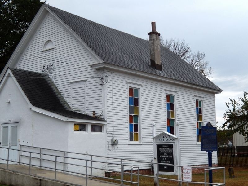
Zion African Methodist Episcopal Church-The roots of this congregation can be traced to 1845, when a group of local residents met to formally organize Zion African Methodist Episcopal Church. With several churches established in the area by free . . . — — Map (db m141317) HM
In the early 1890s Clayton was home to an increasing population of African-Americans, many of whom were railroad workers. Byrd's African Methodist Episcopal (A.M.E.) Church was built in 1894 to accommodate this growing community who previously had . . . — — Map (db m141340) HM
On Easr Loockerman Street at Federal Street, in the median on Easr Loockerman Street.
Richard Allen founded and became the first Bishop of the African Methodist Episcopal Church in 1816. Born into slavery in Philadelphia, Pennsylvania, on February 14, 1760, Allen and his family were sold to a family near Dover in 1772. While there, . . . — — Map (db m39093) HM
On Forrest Street (Delaware Route 8) west of Gibbs Drive, on the right when traveling west.
On November 13, 1922, 210 children and 6 teachers marched from two old school buildings located on Slaughter Street and Division Street to a new school for African-American students in Dover. Funding for the building was provided by the Delaware . . . — — Map (db m39064) HM
On N. Queen Street at Fulton Street on N. Queen Street.
Calvary Baptist Church-On January 26, 1883, the Delaware Baptist Union was formally incorporated by the state legislature. The purpose of the organization was to spread the message of the denomination and promote the erection and maintenance of . . . — — Map (db m141273) HM
Established May 15, 1891, by an act of the Delaware General Assembly as the State College for Colored Students, by virtue of the 1890 Morrill Land-Grant Act under the provisions of the 1862 Morrill Act of Congress. Incorporated July 1, 1891. . . . — — Map (db m39054) HM
On College Road, 0.7 miles west of North Dupont Highway (U.S. 13), on the right when traveling west.
On June 17, 1921, the Board of Trustees of the State College for Colored Students, later known as Delaware State College, approved a resolution recommending the establishment of a high school for Negro students on its campus. This was the second . . . — — Map (db m142491) HM
On College Avenue, 0.7 miles west of North Dupont Highway (U.S. 13), on the right when traveling west.
From 1921 until 1952 this simple brick structure, named for its benefactor, Pierre S. Dupont, served as a laboratory-classroom for students enrolled in the teaching course at the State College for Colored Students (now DSU).
The educational . . . — — Map (db m142492) HM
In 1723 Nicholas Loockerman purchased 600 acres of land known as “The Range.” Following his death in 1771, the property passed to his grandson Vincent Loockerman Jr. Evidence suggests that he built the Georgian-style mansion known today . . . — — Map (db m39053) HM
Mount Zion African Methodist Episcopal Church-The genesis of the African Methodist Episcopal Church can be traced to Delaware in 1777, when a young slave named Richard Allen experienced a spiritual awakening at a meeting conducted by an itinerant . . . — — Map (db m141313) HM
On Sharon Hill Road (County Road 161/162) 0.3 miles east of Cahoon Branch Road (County Road 198), on the right when traveling east.
In 1849, Caper and Leah Carlisle deeded a quarter-acre of land to Meeting House Trustees Jacob Allston, Peter Carlisle, James Collins, Perry Hawkins, and Nathaniel White. The Carlisles and the trustees were part of a free African American community . . . — — Map (db m199002) HM
On Carver Road, 0.1 miles north of Forest Street (Delaware Route 8), on the right when traveling north.
In 1947 the General Assembly appropriated funding to build a comprehensive high school for Blacks and other persons of color residing in central Delaware. The site for the new school was selected in 1949. The state and the Delaware School Auxiliary . . . — — Map (db m243657) HM
St. Paul AME was established as a congregation in 1830. Members met in congregants’ houses and public spaces before building a church. Construction of the church began in 1895 on New Street making St. Paul the last of eleven AME churches built in . . . — — Map (db m142641) HM
A native of Virginia's Eastern Shore, Mifflin came to Delaware as a young man. Born into a slaveholding Quaker family, he manumitted his own slaves in 1774-75 and later became one of America's foremost abolitionists of the 18th century. As an elder . . . — — Map (db m39456) HM
It is believed that parishioners of Bethel African Methodist Episcopal Church were worshiping in a private residence on North Street by 1859. The church eventually moved to a site on Church Street to accommodate the growing congregation. On March 2, . . . — — Map (db m69034) HM
Whitehall Plantation, once owned by the Chew family, contained over 400 acres of land and was worked solely by enslaved labor. Among those enslaved was Richard Allen who was born here and later founded the African Methodist Episcopal Church. By 1798 . . . — — Map (db m142525) HM
In 1919, a new era for education in Delaware was initiated when a statewide effort to replace old and outdated facilities was undertaken. In 1922, the new Smyrna Colored School opened its doors for African-Americans and other persons of color . . . — — Map (db m141287) HM
On Monrovia Avenue south of East Commerce Street (Delaware Route 6), on the right when traveling south.
The name Union Cemetery is derived from the fact that this burial site was created to inter deceased members affiliated with the African-American houses of worship in this area. Originally owned by James and Hester Till, the land for the cemetery . . . — — Map (db m130460) HM
On Willow Grove Road (Delaware Route 10) at Henry Cowgill Road (Delaware Route 10), on the left when traveling north on Willow Grove Road.
Samuel D. Burris, a free African-American conductor on the Underground Railroad resided in the Willow Grove area during the 1840s. He helped enslaved people find their pathway to freedom in Philadelphia. Caught for aiding and abetting runaway slaves . . . — — Map (db m142503) HM
On Bear Christiana Road, on the right when traveling north.
The African Union Church (AUC) of Christiana Bridge built a wood-framed church on this site in 1819. The AUC was the first incorporated religious group in the country controlled entirely by African Americans. The congregation replaced the structure . . . — — Map (db m243662) HM
On N. Old Baltimore Pike (Delaware Route 7), on the right when traveling north.
Formal education for African American children in Christiana began in the 1880s with the construction of a one-room schoolhouse. Many African American schools in existence at this time were marked by dilapidated facilities, a lack of running water, . . . — — Map (db m145173) HM
On N. Old Baltimore Pike (Delaware Route 7) at Bayard Street, on the left when traveling north on N. Old Baltimore Pike.
In 1813 a group of African-American Methodists led by Peter Spencer formed an independent denomination that came to be known as the African Union Church. It was the first incorporated religious body in the United States controlled entirely by . . . — — Map (db m145162) HM
On Hickman Road (Delaware Route 491), on the right when traveling north.
The industrial expansion of Brandywine Hundred in the late 19th and early 20th centuries was largely reflective of national trends in the growth and development of heavy industry. As large corporations moved to locations outside of major cities, . . . — — Map (db m154138) HM
On Green Street at Lawson Street, on the right when traveling south on Green Street.
Constructed 1924-25. Also known as the Green Street School. Prominent in United States history as the first public high school in the 17 segregated states to be legally integrated.
In January 1951, eight black students applied for admission. Due . . . — — Map (db m14705) HM
Near 5th Street (Route 9) at 7th Street, on the right when traveling east.
In 1835 five trustees of the African Union Church purchased this half acre of land for $80, thereby establishing a church, now razed, and cemetery. Throughout its active years the church and cemetery served the residents of Polktown, one of the . . . — — Map (db m244708) HM
On Clinton Street, 0.1 miles south of Harbor Street when traveling south.
Although the idea of a waterway crossing the upper Delmarva peninsula was suggested in the 1600s, the canal did not become a reality until 1829. Over 2,600 workers, including many Irish immigrant and African-American laborers, dug the canal with . . . — — Map (db m174514) HM
On Madison Street, 0.2 miles south of 5th Street (Delaware Route 9), on the right when traveling south.
This building, formerly known as Delaware City School #118C, served as a school for the African American students of Delaware City between the years of 1922 and 1961. During these years 13 teachers taught over 300 students. — — Map (db m174522) HM
Near Madison Street, 0.3 miles south of 5th Street.
In 1919 Delaware radically altered its state school system, opening a new era in the education of African-American youth. Progress was stimulated by the efforts of the Delaware School Auxiliary Association and its primary supporter, P.S. duPont, who . . . — — Map (db m10445) HM
On Michael N. Castle Trail, 0.3 miles south of 5th Street (Delaware Route 9), on the right when traveling north.
In 1914, the Equal Suffrage Study Club, founded by and for African American women, encouraged the public to campaign for women's voting rights and inclusion of African American women. This club was one of Delaware's most active suffrage . . . — — Map (db m205501) HM
Near Michael N. Castle Trail, 0.4 miles south of 5th Street (Delaware Route 9), on the right when traveling south.
The African American community known today as Polktown is one of the earliest remaining free black settlements in Delaware and has been continuously occupied for nearly two centuries. It extended on both sides of the historic branch canal and . . . — — Map (db m244709) HM
The African Union Church once stood on this site adjacent to the cemetery. The church was a branch of the original "Spencer Churches," founded by Wilmington's Peter Spencer in 1813. In 1835, five trustees of the church - Perry Reynolds, Noah . . . — — Map (db m244731) HM
Near 5th Street (Delaware Route 9) at 7th Street, on the right when traveling east.
This cemetery is the final resting place for five Civil War veterans. The United States War Department established the Bureau of Colored Troops on May 22, 1863 under General Order 143. These were free African American men who served in a segregated . . . — — Map (db m244717) HM
Near 5th Street (Delaware Route 9) at 7th Street, on the right when traveling east.
Typical of a 19th century working class community, this burial ground likely contained a large number of wooden and fieldstone markers. Open unmarked areas indicate that was probably the case. Many of these handmade markers have disappeared over . . . — — Map (db m244729) HM
In 1813 a group of African-American Methodists formed an independent denomination known as the African Union Church. It was the first incorporated religious body in the United States controlled entirely by African-Americans. In 1866 the African . . . — — Map (db m92146) HM
Local tradition states that a school was present at this location as early as 1829. However, in 1878 the first documented school for African-Americans in Hockessin was established in this vicinity. The school was funded and built primarily by the . . . — — Map (db m94251) HM
Also known as the Hockessin Colored School, this building was constructed in 1920 to serve the needs of the communities African-American students. Funding for construction was provided by the Delaware School Auxiliary Association and its primary . . . — — Map (db m92145) HM
Born in 1899 in Washington DC. James Henry Winters was a pitcher in the Negro leagues from 1919-1933. Winters, who was also known as "Jesse" and "Nip," was one of the top left-handed pitchers of his day. Known for his wild style and pitching speed, . . . — — Map (db m143839) HM
On East Main Street (County Route 299) near Dove Run Blvd, on the left when traveling west.
Near this location were the farms of John Alston (1794-1872) and John Hunn (1818-1894), cousins who shared the Quaker faith and were well documented operatives on Delaware's Underground Railroad. John Alston sometimes employed fugitives as laborers . . . — — Map (db m88341) HM
The Louis L. Redding Comprehensive High School opened in 1953 and served African American students in grades 1-12 in the Middletown area. It replaced the smaller Middletown School 120-C, a three-room wood structure on East Lake Street. The school . . . — — Map (db m141497) HM
Built in 1923 with funding provided by Pierre S. duPont for schools in Delaware, this school replaced New Castle’s first school for “colored” students that was built in 1867 on Williams Street. The Delaware School Auxiliary Association provided . . . — — Map (db m92290) HM
On East 4th Street, on the right when traveling east.
In 1854, a Methodist Society was organized in the African American community in New Castle. Not long after the society's inception, the group adopted the name Mount Salem Methodist Church and purchased land on which to build a church. Mount Salem's . . . — — Map (db m94193) HM
On Buttonwood Avenue, on the left when traveling east.
In 1919 a school was established in the Buttonwood Methodist Church to serve the needs of “colored” students in the growing neighborhood. The first teacher was James Matthew Coulbourne. In 1926 a new one room school housing grades 1-8 was built here . . . — — Map (db m92291) HM
On New Castle Avenue (Route 9) at Cherry Lane, on the right when traveling north on New Castle Avenue.
On February 24, 1959 George, Lucille, and Geraldine Rayfield, an African American family, moved into their new home at 107 Bellanca Lane. As they moved in 300 protesters gathered out front, angered over the news that the Rayfields had moved into the . . . — — Map (db m130574) HM
On Dayett Mills Road near Old Baltimore Pike, on the right when traveling south.
If you are just "passing through" or are a new resident or even a life-long Delawarean, we hope to spark your interest in the varied activities available in the Pencader Hundred Area. Whether your are experiencing these for the first time or . . . — — Map (db m156918) HM
On Dayett Mill Road south of Old Baltimore Pike, on the right when traveling south. Reported permanently removed.
The Iron Hill Museum is dedicated to the study of human and natural history of the Iron Hill Area. The Museum is currently engaged in a project to restore the Iron Hill School #112C and document the experiences of African-American students who . . . — — Map (db m158406) HM
On New London Road (Delaware Route 896), on the right when traveling north.
Mt. Zion Union UAME was founded in 1868 in an abandoned blacksmith shop near Boogle Run at the corner of New London Rd and Ray St. Congregants walked three miles to St. Daniels UAME in Iron Hill before the establishment of Mt. Zion. In 1869 the . . . — — Map (db m154881) HM
The first documented public school for African-American youth in the Newark community was established in 1867 by the Bureau of Refugees, Freedmen and Abandoned Lands. This was one of several schools established in Delaware during the post-Civil War . . . — — Map (db m154662) HM
On Cleveland Avenue at New London Road (Delaware Route 896), on the right when traveling east on Cleveland Avenue.
The African American New London Road community can be traced back to 1786 when free black families began settling in the area. The community clustered around New London Road and was bounded by Cleveland Avenue to the south and Corbit and Ray Streets . . . — — Map (db m154318) HM
On New London Road (Delaware Route 896) at Corbit Street, on the right when traveling south on New London Road.
You are standing in the heart of Newark's New London Road community — a historically African-American enclave whose story, though largely untold, is a vital part of the city's larger history and cultural heritage.
New London began in the . . . — — Map (db m154931) HM
On W. Cleveland Ave., on the right when traveling east.
The Improved Benevolent Protective Order of Elks of the World was formally organized in 1898. Designed to promote civic improvements, the IBPOEW is one of the largest fraternal organizations of its type in the world. Responding to the request of a . . . — — Map (db m9974) HM
On Hillside Road at New London Road Rt. 896, on the right when traveling south on Hillside Road.
This congregation was organized circa 1848. Early meetings were held in a log cabin at this location on land that was conveyed to trustees of the "Protestant Methodist Church" in 1850. In 1866 the members of the First Colored Methodist Protestant . . . — — Map (db m9968) HM
On South Old Baltimore Pike near Robert L. Melson Lane.
Education for ALL, Past and Present: Iron Hill School, No. 112C
The Past:
The Iron Hill School #112C, was one of the schools built for black school children in Delaware by philanthropist Pierre S. duPont as part of a $100 million dollar . . . — — Map (db m189506) HM
The Iron Hill area was a community of African American farming and mining families. Constructed in 1923, Iron Hill School #112-C was one of over 80 schools built with funding from Pierre S. duPont, who sought to replace rundown public schools with . . . — — Map (db m94286) HM
Near South Old Baltimore Pike east of Whittaker Road, on the right when traveling west.
1800
Total Pencader Population: 2,132 100%
Number of Free Black Residents in Pencader:201 9% of Total Population
Number of Free Black Persons Living in Free Blk. . . . — — Map (db m238418) HM
Near South Old Baltimore Pike east of Whittaker Road, on the right when traveling west. Reported damaged.
On the ground before you are the archaeological remains of the original Iron Hill School #112C. The one-room school was constructed for the education of African-American students in the Iron Hill area. Archival records suggest that the school . . . — — Map (db m238419) HM
Near South Old Baltimore Pike east of Whittaker Road, on the right when traveling west.
"War Between the States,
Brother Against Brother"
The civil war officially began on April 12, 1861 when Confederate forces bombarded the Union controlled Fort Sumter.
Delaware was a Border . . . — — Map (db m238413) HM
Near South Old Baltimore Pike east of Whittaker Road, on the right when traveling west.
"Almost all of the Africans who came to America before 1865 were enslaved… Struggling to establish stable lives despite harsh conditions. Once they were legally free, their troubles were far from over, since African Americans were . . . — — Map (db m238415) HM
Near South Old Baltimore Pike east of Whittaker Road, on the right when traveling west.
Could it be …
1. a natural hill that formed millions of years ago?
2. a Native American burial mound?
3. a spoils pile from iron mining?
4. an abandoned charcoal furnace or collier's hut used by Abbington Iron Works? . . . — — Map (db m238414) HM
On Kiamensi Ave. at Newport Rd., on the right when traveling south on Kiamensi Ave..
In 1975 William Julius “Judy” Johnson became the first Delawarean elected to the National Baseball Hall of Fame. During his career, 1921 through 1936, Johnson was considered the best third baseman in the Negro Leagues. In 1935, Johnson . . . — — Map (db m145811) HM
On Main Street, 0.1 miles west of US 13 South, on the right when traveling east.
Believed to be one of the smallest Quaker Meeting Houses in the nation, the Appoquinimink Friends Meeting House was built in 1785 by David Wilson and presented to the Friends as a gift. Local tradition identifies this structure as a stop on the . . . — — Map (db m10308) HM
On Market Street at Stewart St., on the right when traveling west on Market Street.
The Presbyterian Church, on the opposite corner across the intersection, now occupies the site originally intended as Port Penn's market square. Dr. David Stewart, Sr., believed to be the founder of Port Penn, envisioned a central market similar . . . — — Map (db m10395) HM
On Market Street at Liberty Street, on the right when traveling west on Market Street. Reported permanently removed.
Built in 1856, this schoolhouse served to educate Port Penn's children until 1961. Now a State Parks interpretive center, it continues to teach people about the Port Penn community.
Eight grades of students attended classes in the two rooms of . . . — — Map (db m10430) HM
"The Rocks," a natural landing on the Christina River, was critical to Wilmington's Underground Railroad network. Captain James Watson Fountain outfitted a schooner to secretly carry freedom-seekers north from North Carolina and Virginia. Black . . . — — Map (db m226518) HM
On King Street at Fifth Street, on the left when traveling south on King Street.
Delaware remained a racially segregated society until the mid-twentieth century. Though the segregation of public schools was supported by the “separate but equal” doctrine that had been upheld by the nation’s highest court, the facilities and . . . — — Map (db m165893) HM
On North Shipley Street at W. 9th Street on North Shipley Street.
In August 1958, Wilmington City Councilman and Civil Rights activist William “Dutch” Burton worked with the NAACP to expose the racially discriminatory practices of the Eagle Coffee Shoppe. The restaurant was located on this site in a . . . — — Map (db m140547) HM
On North French Street at East 9th Street, on the left when traveling south on North French Street.
On this site in 1805 an historic institution in the Black experience was built. Its membership was commended by Bishop Francis Asbury when he visited the new church in 1806.
"The Africans here have a house to . . . — — Map (db m217948) HM
In 1805 a group of African-Americans, desiring greater freedom of worship, withdrew from Asbury Methodist Episcopal Church to form a separate congregation. Led by Peter Spencer and William Anderson, they established what was then known as the . . . — — Map (db m14757) HM
On North French Street, 0.1 miles north of East Eighth Street, on the right when traveling south. Reported permanently removed.
Born a slave, Bishop Spencer was the father of Delaware’s independent Black church movement. In 1813, he founded the Union Church of Africans, presently known as the African Union Methodist Protestant Church. The mother AUMP church . . . — — Map (db m144198) HM
On 11th Street at Wilson Street, on the right when traveling east on 11th Street.
In 1875 the Delaware General Assembly enacted legislation requiring the racial segregation of public places such as train stations, hotels, and restaurants. For most of the next century this practice was strictly enforced. Established at this . . . — — Map (db m10920) HM
On North French Street, 0.1 miles south of East Ninth Street, on the left when traveling south.
Named in honor of Delaware’s first Afro-American attorney, graduate of Howard High School, Brown University, and Harvard Law School, admitted to the Delaware Bar in 1929, pioneer in the struggle for equality and tireless advocate in civil rights . . . — — Map (db m143952) HM
On East 11th Street just east of Wilson Street, on the right when traveling east.
Born in Alexandria, Virginia, relocated to 203 E. 10th Street, Wilmington, Delaware. Redding graduated from Howard High School in 1919, and with honors from Brown University in 1923. After college, Redding taught in Florida, and at Morehouse . . . — — Map (db m217947) HM
On East 5th Street, on the right when traveling west.
Established in 1813 by free African American Peter Spencer, the Union Church of Africans was the first independent African American religious denomination in the United States. After leaving Asbury Methodist Episcopal Church to start Ezion . . . — — Map (db m94195) HM
On French Street, on the right when traveling north.
The cradle of African-American Catholicism in Delaware, St. Joseph Church was organized in 1889 by Father John A. DeRuyter of the Josephites. Services were first held in the basement of St. Mary’s Church on 6th and Pine Streets. Incorporated as St. . . . — — Map (db m10919) HM
On East 7th Street at Spruce Street, on the left when traveling east on East 7th Street.
Zion Church in New York City, organized in 1796, was the catalyst by which the African Methodist Episcopal Zion denomination was established in 1821. By the 1870’s a number of Wilmington residents had affiliated themselves with this growing . . . — — Map (db m11011) HM
On French Street, 0.1 miles north of 9th Street, on the right when traveling south.
In 1876, a group of African American men seeking opportunities for political involvement, socio-economic freedom, and cultural enrichment in Wilmington formed The Monday Club. The club incorporated in 1893 and was named for members' only day off . . . — — Map (db m188451) HM
Walnut Street YMCA (Young Men's Christian Association) was designed by Wilmington architect G. Morris Whitehead II as a community center for the city's African American population. Construction began on the three-story structure in 1939 and the . . . — — Map (db m94204) HM
On West 18th Street at Baynard Boulevard on West 18th Street.
[Panel 1:]African American Medal of Honor Recipients Memorial The Medal of Honor takes its place in our country as the highest award for military valor. The honor, awarded by the President in the name of Congress, may only be accorded an . . . — — Map (db m173924) HM
The origin of this congregation can be traced to 1875, when members of a Sunday School class affiliated with First Baptist Church met to plan the organization of a separate church to serve the needs of the city's African-American residents. . . . — — Map (db m13583) HM
On North Walnut Street (Business U.S. 13), on the right when traveling north.
On May 10, 1846, a group of African-American residents of Wilmington who had affiliated themselves with the African Methodist Episcopal Church held a meeting for the purposes of electing trustees and organizing as a corporate body. At the time, . . . — — Map (db m168200) HM
On East 7th Street west of Wilmington Industrial Park, on the right when traveling east.
A black man named Anthony was among the first permanent settlers of New Sweden. He came to the colony from the West Indies in 1639 aboard the Swedish ship Vogel Grip. Records indicate that Black Anthony became a free man named Antoni Swart, an . . . — — Map (db m228037) HM
On 2nd Street at Walnut Street, on the left when traveling west on 2nd Street.
On May 2, 1914, the Delaware Congressional Union and Delaware Equal Suffrage Association held a parade in Wilmington. Approximately 400 suffragists marched from the Pennsylvania Railroad Station to the New Castle County Court House at 10th and . . . — — Map (db m184921) HM
On East 10th Street just west of North Pine Street, on the right when traveling west.
Hattie M. Phelan was the first African-American woman elected to the Wilmington City Council. She was appointed to council in 1967 to fill a mid-term vacancy and was subsequently re-elected for two more terms.
Councilwoman Phelan was . . . — — Map (db m244836) HM
On East 10th Street just west of North Pine Street, on the right when traveling west.
This garden was created by the people of the Eastside and dedicated to the memory of the first African American woman on the Wilmington City Council — — Map (db m244834) HM
On North Poplar Street at West 13th Street, on the left when traveling south on North Poplar Street.
Founded in 1867 by the Association for the Moral Improvement and Education of Colored People and named for Civil War General Oliver Otis Howard, the original school was located at 12th and Orange Streets. Pierre S. DuPont was the major benefactor . . . — — Map (db m10914) HM
On South Broom Street at Sycamore Street, on the left when traveling south on South Broom Street.
In observance of the Nation’s Bicentennial, this park by resolution of the city council of Wilmington was named
In Memory of
Tadeusz Kosciuszko
1746 ~ 1817
Colonel, Army of the United States
American Soldier
Major General, . . . — — Map (db m68371) HM
On West 6th Street at North Franklin Street, on the right when traveling east on West 6th Street.
Office of the Adjutant General
State Armory
Wilmington
20 March 1991
Permanent Orders 10-1(S)
McCoy, James Robert - Corporal Troop K 2D
Armored Cavalry Regiment United States Army Amberg Germany
The . . . — — Map (db m240823) HM WM
On 2nd Street at Clayton Street, on the right when traveling west on 2nd Street.
Regarded as one of the best third basemen to have played in the Negro Leagues, William Julius "Judy" Johnson (1899-1989) grew up nearby on the west side of Delamore Place. During his youth, Johnson played baseball at various sand lots in the city, . . . — — Map (db m169000) HM
On North Spruce Street (U.S. 13) at Bennett Street, on the right when traveling west on North Spruce Street.
Clifford Brown, also known as "Brownie," was a highly influential and respected jazz trumpeter.
A native of Wilmington, Brown began learning trumpet at the age of 13. He went on to tour throughout the United States and Europe, making brief . . . — — Map (db m217894) HM
On Clifford Brown Walk at East 16th Street, on the right when traveling north on Clifford Brown Walk.
Wilmington native Clifford Brown was one of the greatest jazz trumpet players of all time. Known to his friends as "Brownie," he played jazz with such legends as Lionel Hampton, Art Blakey, and Max Roach. In 1954, Down Beat magazine named Brown . . . — — Map (db m216008) HM
In 1938 the Wilmington Board of Education proudly dedicated a new vocational high school on the northwest corner of Market and 14th Streets. State and city dignitaries attended the ceremony that officially opened a school that for the next three . . . — — Map (db m131160) HM
On North Market Street (Business U.S. 13) at South Park Drive, on the left when traveling north on North Market Street.
This bridge is named for Dr. James H. Sills, Jr. to honor his service as a State Legislator, as the first African American Mayor of Wilmington and for his tenure as a Wilmington City Council Member. His personal love, commitment and dedication to . . . — — Map (db m210796) HM
On East 16th Street east of Clifford Brown Walk, on the right when traveling east.
This bridge is named for James M. Baker, to honor his service as the first African American President of the Wilmington City Council and the first Mayor to serve three consecutive 4-year terms. He is appreciated for his love for this city and his . . . — — Map (db m216007) HM
On North Tatnall Street just south of West Girard Street, on the left when traveling south.
Blanche Stubbs, 1872-1952. Equal Suffrage Study Club leader & advocate for African American voting and civil rights. Lived here. — — Map (db m184935) HM
On North French Street just north of East 13th Street, on the right when traveling north.
Alice Dunbar-Nelson, 1875-1935. Teacher, author, civil rights leader. Elected president Equal Suffrage Study Club 1914. Lived here. — — Map (db m186358) HM
On Anderson Drive at Bethune Drive on Anderson Drive.
The Federal Housing Act of 1949 established a goal of “a decent home and a suitable living environment for every American family.” However, a segregated housing market put this goal beyond the reach of African American veterans. In that year, . . . — — Map (db m92289) HM
148 entries matched your criteria. The first 100 are listed above. The final 48 ⊳