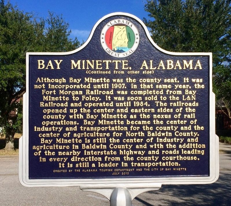
By Mark Hilton, January 14, 2017
Bay Minette, Alabama Marker (side 2)
GEOGRAPHIC SORT WITH USA FIRST Geographic Sort Title Sort Marker Number Sort Marker Number Sort for Trails Publication Order Sort Publication Order Sort A Erected Year Sort Most Viewed Sort Most Recent-Interest Sort Most Recently Changed Sort SEE FAQ #33 FOR DESCRIPTIONS
On West 2nd Street east of McMillan Avenue, on the right when traveling east.
On Orange Beach Boulevard (Alabama Route 161) at John M Snook Drive, on the right when traveling south on Orange Beach Boulevard.
On East Broad Street 0.1 miles north of North Livingston Ave, in the median.
On North Main Street (Alabama Route 51) 0.6 miles south of West Street, on the right when traveling south.
On Main Street (Alabama Route 25) at 1st Street, on the right when traveling south on Main Street.
On U.S. 82 near Greenwood Avenue, on the right when traveling west. Reported damaged.
On Lafayette Street North (U.S. 431) just south of Alabama Avenue, on the right when traveling north.
On North Lanier Avenue at 1st Street, on the left when traveling north on North Lanier Avenue. Reported permanently removed.
On North Lanier Avenue at 1st Street on North Lanier Avenue.
On Sand Rock Avenue at Wildcat Street, on the left when traveling north on Sand Rock Avenue.
On Main Street Circle west of Main Street South.
Near Court Square (Road 31) at 2nd Avenue North, on the right when traveling south.
On Alabama Route 22 at Jackson Street, on the right when traveling west on Alabama Route 22.
Near County Road 16 0.4 miles west of Alabama 22, on the right when traveling west.
On County Road 293 at County Road 52, on the right when traveling south on County Road 293.
Paid Advertisement
On U.S. 31 at Old US Highway 31, on the right when traveling north on U.S. 31.
On Alabama Route 95 0.4 miles south of County Road 48, on the left when traveling south.
On U.S. 231 south of State Line Road, on the right when traveling north.
On North Oates Street (Business U.S. 231) at West Main Street (Business U.S. 84), on the right when traveling north on North Oates Street.
On Main Street at Browntown Road (County Road 47/416), on the left when traveling north on Main Street.
On Lee Highway/John T. Reid Parkway (State Highway 2/72) at County Road 7, on the left when traveling west on Lee Highway/John T. Reid Parkway. Reported missing.
On Municipal Lane, on the right when traveling east.
On Avenue H at 6th Street, on the right when traveling south on Avenue H.
On Rock Creek Road 0.1 miles south of Port Birmingham Road ( Road 269), on the left when traveling south.
On East Mobile Street at North Court Street on East Mobile Street.
On South Jefferson Street at Market Street, on the right when traveling north on South Jefferson Street.
On Huntsville Highway (U.S. 231/431) at Hunter Road, on the left when traveling north on Huntsville Highway.
On U.S. 278 at milepost 66, 0.2 miles north of Road 2, on the right when traveling north.
On North Royal Street at St Michael Street, on the right when traveling north on North Royal Street.
On North Conception Street 0.1 miles north of St Michael Street, on the right when traveling north.
On Government Street (U.S. 98) at South Jackson Street, on the right when traveling west on Government Street.
Paid Advertisement
Near North Bainbridge Street at Dexter Avenue, on the right when traveling south.
On Jefferson Street at Pickens Street, on the right when traveling east on Jefferson Street.
On Longview Street at Jackson Street, on the right when traveling north on Longview Street.
Near Chapel Street at Longview Street.
On Cogswell Avenue at 18th Street, on the right when traveling west on Cogswell Avenue.
On 1st Avenue North at 19th Street North, on the right when traveling west on 1st Avenue North.
On 7th Street at Martin Luther King, Jr. Boulevard, on the right when traveling west on 7th Street.
On Court Street north of Central Avenue ( Route 56), on the left when traveling north.
On West 4th Avenue, on the right when traveling west.
On Egan Drive at Tatitlek Avenue, on the right when traveling west on Egan Drive.
On 1st Avenue east of Cushman Street, on the left when traveling east.
On Main Street north of 3rd Street, on the right when traveling north.
On East Toughnut Street at South 3rd Street, on the left when traveling west on East Toughnut Street.
Paid Advertisement
Near Interstate 10 at milepost 181.
Near Old Post Road 0.8 miles south of State Route 169.
On North Main Street (U.S. 425) at East Adams Street, on the right when traveling north on North Main Street.
On Northeast John Deshields Boulevard 0.1 miles east of Northeast Martin Luther King, Jr. Parkway, on the right when traveling east.
On East Cedar Street at North Main Street (Business U.S. 63), on the right when traveling west on East Cedar Street.
Near Main Street at North Lakeshore Drive (Arkansas Highway 144).
On Clay Street at South 4th Street, on the right when traveling east on Clay Street.
Near County Road 347, on the right when traveling north.
On Arkansas 35 at 116, on the right when traveling east on Arkansas 35.
On South Moose Street north of East Church Street, on the right when traveling north.
On South Bridge Street (Arkansas Route 9) at East Burrow Street, on the right when traveling west on South Bridge Street.
On South Main Street at West Washington Avenue, on the right when traveling south on South Main Street.
On Robert S Moore Avenue at Natchez Street, on the left when traveling east on Robert S Moore Avenue.
On Arkansas Route 1 0.1 miles south of Route 138.
On Arkansas Route 1 at Front Street, on the right when traveling east on Arkansas Route 1.
Paid Advertisement
On West Commercial Street (Highway 64) at South 2nd Street, on the right when traveling east on West Commercial Street.
Near Central Avenue (Arkansas Route 7) at Mountain Street, on the right when traveling south.
On U.S. 278 at State Route 26, on the left when traveling north on U.S. 278.
On North Main Street near Isaac C. Perkins Bypass (U.S. 278 W).
On 3rd Street at Main Street, on the right when traveling west on 3rd Street.
On U.S. 63/79 0.1 miles north of Myrtle Street.
On East 3rd Street at Spruce Street, on the left when traveling east on East 3rd Street.
On County Road 133 at State Route 234, on the right when traveling west on County Road 133.
On North 2nd Street north of West Main Street (State Route 32), on the right when traveling north.
On Arkansas Route 108 south of Route 108 Spur, on the right when traveling south.
On West Main Street (Business U.S. 412) at West War Eagle Avenue, on the right when traveling east on West Main Street.
On East Old Main Street, on the right when traveling west.
On George Street west of East Street, on the right when traveling west.
On Church Street just east of Stone Street (State Route 7), on the left when traveling east.
On Courthouse Square at North Washington Avenue (State Route 26), on the left when traveling west on Courthouse Square.
On West Courthouse Square just west of North 2nd Street, on the right when traveling west.
Paid Advertisement
On U.S. 62/67 north of South Bettis Street, on the right when traveling north.
On Center Street south of Nome Street, on the right when traveling south.
On West Stillwell Avenue at North 3rd Street, on the right when traveling west on West Stillwell Avenue.
On South Izard Street south of Court Avenue, on the left when traveling south.
On North Washington Avenue at East Elm Street, on the right when traveling north on North Washington Avenue.
On U.S. 167 near East State Line Road (East Third Street), on the right when traveling south.
On West Arch Avenue at North Spruce Street, on the left when traveling east on West Arch Avenue.
On North 3rd Street north of Spruce Street, on the right when traveling north.
On Alpine State Highway (California Route 89) at Water Street, on the right when traveling north on Alpine State Highway.
On North Main Street, on the left when traveling north.
On Sutter Hill Road at Eureka Road, on the right when traveling west on Sutter Hill Road.
On San Pablo Dam Road, on the right when traveling south.
On Los Angeles Street west of North Alameda Street, on the right when traveling south.
On Dutra Street at King Street, on the right when traveling north on Dutra Street.
On Dutra Street at King Street, on the right when traveling north on Dutra Street.
Paid Advertisement
On Dutra Street at King Street, on the right on Dutra Street.
Near Serrano Road at Winding Way, on the right when traveling north.
Near L Street west of 13th Street, on the left when traveling west.
Near N Street near 13th Street, on the left when traveling east.
︽
2147 entries matched your criteria. The first 100 are listed above.
Next 100 ⊳