3911 entries match your criteria. Entries 201 through 300 are listed.⊲ Previous 100 — Next 100 ⊳
Environment Topic
By J. J. Prats, November 30, 2018
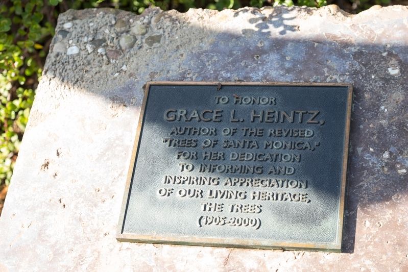
Grace L. Heintz “Trees of Santa Monica” Tablet
| 201 ► California, Los Angeles County, Santa Monica, Wilshire Montana — “Trees of Santa Monica” — |
| On Ocean Drive south of California Avenue / California Incline, on the right when traveling south. | |||
| 202 ► California, Marin County, Inverness — Point Reyes Light — Point Reyes National Seashore — |
| Near Sir Francis Drake Boulevard. | |||
| 203 ► California, Marin County, Inverness — The Rock Plants — Point Reyes National Seashore — |
| Near Sir Francis Drake Boulevard. | |||
| 204 ► California, Marin County, Iverness — Point Reyes Conglomerate — Point Reyes National Seashore — |
| On Sir Francis Drake Blvd. | |||
| 205 ► California, Marin County, Mill Valley — Fall in Muir Woods — Muir Woods National Monument — |
| On Muir Woods Road. | |||
| 206 ► California, Marin County, Point Reyes Station — Sea Life in These Waters — Gulf of the Farallones & Cordell Band — National Marine Sanctuaries — |
| Near Sir Francis Drake Boulevard north of Chimney Road Road. | |||
| 207 ► California, Marin County, Point Reyes Station — Whalewatching — |
| Near Chimney Rock Road. | |||
| 208 ► California, Marin County, Sausalito — Cold War Legacy: Missiles to Marine Mammals — Marin Headlands Golden Gate National Park — |
| Near Bunker Road near Kirkpatrick Streetthus. | |||
| 209 ► California, Marin County, Sausalito — The Bay Transformed — |
| Near U.S. 101, on the right when traveling north. | |||
| 210 ► California, Marin County, Tiburon — Backcountry — |
| 211 ► California, Marin County, Tiburon — 2 — Feed Lot For Oysters — Compare Then and Now — The Tiburon Historical Trail — |
| 212 ► California, Marin County, Tiburon — Melting Glaciers + Rising Seas = — San Francisco Bay & Angel Island — |
| 213 ► California, Marin County, Tiburon — Saving and Protecting Our Bay — |
| 214 ► California, Mariposa County, Fish Camp — A New Vision for an Ancient Grove — Mariposa Grove of Giant Sequoias — Yosemite National Park — |
| Near Mariposa Grove Road, 2.1 miles east of Wawona Road (California Route 41). | |||
| 215 ► California, Mariposa County, Yosemite National — The Journey to Yosemite — |
| On El Portal Road, 1.7 miles west of Big Oak Flat Road, on the right when traveling west. | |||
| 216 ► California, Mariposa County, Yosemite National Park — A Seasonal Lake — |
| 217 ► California, Mariposa County, Yosemite National Park — Bracken Fern and Baskets — |
| 218 ► California, Mariposa County, Yosemite National Park — Disappearing Waterfalls — |
| Near Wawona Road south of California Route 41. | |||
| 219 ► California, Mariposa County, Yosemite National Park — El Capitan — |
| On Southside Drive, 0.2 miles east of Wawona Road, on the left when traveling east. | |||
| 220 ► California, Mariposa County, Yosemite National Park — Glaciers at the Gate — |
| On Southside Drive, 0.2 miles east of Wawona Road, on the left when traveling east. | |||
| 221 ► California, Mariposa County, Yosemite National Park — John Muir... The Woodcutter — |
| Near Northside Drive, on the right when traveling west. | |||
| 222 ► California, Mariposa County, Yosemite National Park — Mirror Lake Resources — |
| 223 ► California, Mariposa County, Yosemite National Park — Natural Dam — |
| 224 ► California, Mariposa County, Yosemite National Park — Olmsted Point — A Family Legacy — |
| On Tioga Pass Road (California Route 120), on the right when traveling east. | |||
| 225 ► California, Mariposa County, Yosemite National Park — President Theodore Roosevelt & John Muir Meeting Site — Yosemite National Park — |
| On Southside Drive south of El Portal Road /Northside Drive, on the right when traveling east. | |||
| 226 ► California, Mariposa County, Yosemite National Park — Selling the Sublime — |
| 227 ► California, Mariposa County, Yosemite National Park — The Story of Half Dome — |
| On Sentinel Drive, 0 miles north of Southside Drive, on the right when traveling north. | |||
| 228 ► California, Mariposa County, Yosemite National Park — Visitors at Mirror Lake — |
| 229 ► California, Mariposa County, Yosemite National Park — Waterfalls of Yosemite Valley — |
| On El Portal Road, 1.7 miles west of Big Oak Flat Road, on the right when traveling west. | |||
| 230 ► California, Mariposa County, Yosemite National Park — 790 — Yosemite Valley — 1864-1964 — |
| Near Village Drive north of Northside Drive. | |||
| 231 ► California, Modoc County, Alturas — Working Farm Roots — The Creation of Modoc National Wildlife Refuge — |
| 232 ► California, Modoc County, Newell — Raptors - Birds of Prey — |
| On County Road 126 (County Route 126), on the left when traveling south. | |||
| 233 ► California, Mono County, Walker — The C-130 Crew — Lost During the Cannon Fire - June 17, 2002 — |
| On State Highway 395, on the left when traveling south. | |||
| 234 ► California, Monterey County, Big Sur — Inspiration: A Wild Coast and Lonely — |
| On Cabrillo Highway (State Highway 1 at milepost 37), on the right when traveling south. | |||
| 235 ► California, Monterey County, Big Sur — Red Giants: Trees of the Mist — |
| Near Cabrillo Highway (State Highway 1 at milepost 37). | |||
| 236 ► California, Monterey County, Del Monte Forest — Lone Cypress — Perched over the Pacific for Hundreds of Years |
| On 17 Mile Drive west of California Highway 1, on the right when traveling south. Reported missing. | |||
| 237 ► California, Monterey County, Monterey — Ed Ricketts’s Backyard — Historic Cannery Row — |
| Near Cannery Row. | |||
| 238 ► California, Monterey County, Monterey — Giant Kelp Beyond the Breakers — Historic Cannery Row — |
| Near Cannery Row. | |||
| 239 ► California, Monterey County, Monterey — The Real “Docs” — Historic Cannery Row — |
| Near Cannery Row at Bruce Aris Way (Irving Avenue). | |||
| 240 ► California, Monterey County, San Miguel — The San Andreas Fault — |
| On Parkfield-Coalinga Road, on the left when traveling south. | |||
| 241 ► California, Nevada County, Norden — 16 — Clair Tappaan Lodge — Hwy 40 Scenic Bypass — |
| Near Donner Pass Road near Soda Springs Road, on the right when traveling west. | |||
| 242 ► California, Nevada County, Norden — 17 — Summit Valley — |
| On Donner Pass Road, on the right when traveling east. | |||
| 243 ► California, Nevada County, Soda Springs — Central Sierra Snow Lab — Hwy 40 Scenic Bypass — |
| On Donner Pass Road near Bunny Hill Drive, on the left when traveling east. | |||
| 244 ► California, Nevada County, Soda Springs — Royal Gorge History — A Brief and Recent History of Royal Gorge — |
| On Old Donner Summit (Lake Van Norden) Road near Sugar Bowl Road, on the right when traveling east. | |||
| 245 ► California, Orange County, Anaheim, Anaheim Resort — Santa Ana River Area History — Welcome to the Santa Ana River Trail — |
| On Katella Ave., on the right when traveling east. | |||
| 246 ► California, Orange County, Brea — Olinda Historic Trail — |
| Near Sante Fe Road north of Carbon Canyon Road, on the left when traveling east. | |||
| 247 ► California, Orange County, Fountain Valley — 13 — Joint Outfall System — |
| On Ellis Avenue at Unnamed road to Orange County Sanitation District, on the right when traveling east on Ellis Avenue. | |||
| 248 ► California, Orange County, Fountain Valley — 19 — Talbert Drainage District — |
| On Talbert Avenue at Bushard Street, on the right when traveling west on Talbert Avenue. | |||
| 249 ► California, Orange County, Fountain Valley — 10 — Talbert Home — |
| On Bushard Street, on the right when traveling south. | |||
| 250 ► California, Orange County, Mission Viejo — Oso Creek Trail — |
| On Veterans Way. | |||
| 251 ► California, Orange County, Orange — 37 — Submerged Dam — |
| Near Windes Drive. | |||
| 252 ► California, Plumas County, Belden — Pacific Crest Trail — |
| On Belden Town Road, on the right when traveling west. | |||
| 253 ► California, Plumas County, Blairsden-Graeagle — Winter in the Sierra — A Struggle For Survival — |
| Near Johnsville - McCrea Road (County Highway A14). | |||
| 254 ► California, Plumas County, Quincy — Oakland Camp — |
| On Oakland Camp Road. | |||
| 255 ► California, Riverside County, Idyllwild — The Idyllwild Monument — “Harmony” — |
| On Village Center Drive south of Circle Drive, on the left when traveling south. | |||
| 256 ► California, Riverside County, Palm Springs — The Accidental Sea — |
| Near Tram Way. | |||
| 257 ► California, Riverside County, Palm Springs — The Wilderness Before You — This wilderness region comprises nearly 14,000 acres of rugged, wild beauty. — |
| Near Tram Way. | |||
| 258 ► California, Riverside County, Palm Springs — Wilderness Preservation — In wilderness, people are visitors who do not remain. — |
| Near Tram Way. | |||
| 259 ► California, Riverside County, Temecula — The Great Oak — |
| 260 ► California, Riverside County, Thousand Palms — John Guthrie McCallum — |
| Near Thousand Palms Canyon Road. | |||
| 261 ► California, Sacramento County, Rancho Cordova, Mather — Vernal Pool Grassland — Mather Vernal Pools — |
| On Eagles Nest Road, 2 miles south of Douglas Road. | |||
| 262 ► California, Sacramento County, Sacramento, Central Business District — Acorns, Oaks, and the Native Peoples — |
| On N Street at 15th Street, on the right when traveling east on N Street. | |||
| 263 ► California, Sacramento County, Sacramento, Central Business District — Pinus Pinea — Italian Stone Pine — |
| Near L Street at 10th Street, on the right when traveling east. | |||
| 264 ► California, San Benito County, Pinnacles National Monument — Return to Condor Crags — |
| 265 ► California, San Bernardino County, Baker — Salt Creek — A Desert and Riperian and Wetland Area — |
| On Death Valley Road, 1 mile south of Saratoga Springs Road. | |||
| 266 ► California, San Bernardino County, Baker — World’s Tallest Thermometer — |
| On Baker Boulevard, 0.1 miles east of Death Valley Road (California Route 127), on the right when traveling east. | |||
| 267 ► California, San Bernardino County, Midway — The Mojave Desert — |
| On Interstate 15, 34 miles north of Barstow, on the right when traveling north. | |||
| 268 ► California, San Bernardino County, San Bernardino — 60th Anniversary of the CCC — |
| Near Arrowhead Avenue, on the left when traveling south. | |||
| 269 ► California, San Bernardino County, Twentynine Palms — Champion of the Desert — |
| Near Utah Trail at National Park Drive, on the right when traveling south. | |||
| 270 ► California, San Bernardino County, Twentynine Palms — 11 — The Desert Trail — Bill and Prudie Underhill — |
| On Adobe Road just north of Joshua Drive, on the left when traveling north. | |||
| 271 ► California, San Diego County, Carlsbad — Buena Vista Reservoir Park — |
| Near Lido Place. | |||
| 272 ► California, San Diego County, Escondido — Daley Ranch — |
| 273 ► California, San Diego County, Pacific Beach — The Ballad of P.B. — |
| On Ocean Boulevard. | |||
| 274 ► California, San Diego County, San Diego — Ellen Browning Scripps — |
| Near Torrey Pines Park Road, 0.9 miles south of North Torrey Pines Road (County Road S21), on the left when traveling south. | |||
| 275 ► California, San Diego County, San Diego — George White Marston — 1850 - 1946 — Friend of His Fellow Men Lover of all Growing Things — |
| 276 ► California, San Diego County, San Diego — San Diego Bay — |
| Near Convention Way at Marina Park Way, on the right when traveling west. | |||
| 277 ► California, San Diego County, San Diego — Stephen Tyng Mather — July 4, 1867 - Jan 2, 1930 — |
| Near Cabrillo Memorial Drive. | |||
| 278 ► California, San Diego County, San Diego, La Jolla — Conserving California's Coastal Treasures — Marine Protected Areas Safeguard Our Ocean's Bounty — |
| On Black's Beach Way. | |||
| 279 ► California, San Diego County, San Diego, Old Town — Site with Many Cultures / Un Sitio de Muchas Culturas — |
| Near Presidio Drive north of Cosoy Way, on the right when traveling west. | |||
| 280 ► California, San Francisco City and County, San Francisco, Alcatraz Island — Western Gulls — Nursery on the Parade Ground — |
| 281 ► California, San Francisco City and County, San Francisco, Chinatown — Watershed History (North Shore) — |
| On Spofford Street near Washington Street, in the median. | |||
| 282 ► California, San Francisco City and County, San Francisco, Golden Gate Park — Dune Stabilization is a Grassroots Effort — |
| Near Stanyan Street west of Haight Street. | |||
| 283 ► California, San Francisco City and County, San Francisco, Lincoln Park — Lands End — Golden Gate National Recreation Area — |
| Near Merrie Way near Point Lobos Avenue. | |||
| 284 ► California, San Francisco City and County, San Francisco, Lower Haight — Watershed History — The Channel Watershed — |
| On Pierce Street at Waller Street on Pierce Street. | |||
| 285 ► California, San Francisco City and County, San Francisco, Presidio of San Francisco — Bringing A Creek Back to Life: Thompson Reach — |
| On Lincoln Boulevard. | |||
| 286 ► California, San Francisco City and County, San Francisco, Presidio of San Francisco — Gulf of the Farallones National Marine Sanctuary — |
| Near Marine Drive. | |||
| 287 ► California, San Francisco City and County, San Francisco, Presidio of San Francisco — Steel, Fog, Salt, Rust, and Paint — |
| Near Coastal Trail. | |||
| 288 ► California, San Francisco City and County, San Francisco, Presidio of San Francisco — Wetlands Renaissance — |
| On Mason Street at Halleck Street, on the right when traveling west on Mason Street. | |||
| 289 ► California, San Francisco City and County, San Francisco, Twin Peaks — Twin Peaks Natural Habitat — |
| Near Christmas Tree Point Road near Twin Peaks Boulevard. | |||
| 290 ► California, San Luis Obispo County, Cambria — 939 — Nitt Witt Ridge — |
| On Hillcrest Drive, on the right when traveling west. | |||
| 291 ► California, San Luis Obispo County, San Simeon — 142-14 — Hearst Ranch — |
| Near SLO San Simeon Road. | |||
| 292 ► California, San Luis Obispo County, San Simeon — Point Piedras Blancas, A Recent Colony — Thousands Strong and Growing… — |
| On Cabrillo Highway (California Route 1) 4.5 miles north of Hearst Castle Road, on the left when traveling north. | |||
| 293 ► California, San Luis Obispo County, Shandon — Powerful Forces at Work — |
| On Route 41, on the right when traveling north. | |||
| 294 ► California, San Mateo County, Moss Beach, Fitzgerald Marine Reserve — Bob Breen: Fitzgerald Marine Reserve's First Park Ranger — |
| On North Lake Street at Nevada Avenue, on the right when traveling west on North Lake Street. | |||
| 295 ► California, San Mateo County, Pacifica — Open Spaces and Wild Places — A Legacy of Land Protection — |
| On Old Devil's Slide Highway west of Cabrillo Highway (California Route 1), on the right when traveling west. | |||
| 296 ► California, Santa Barbara County, Goleta — Arroyo Hondo Fish Passage & Upstream Habitat Restoration — Another Conservation Project of The Land Trust of Santa Barbara County — |
| Near U.S. 101, 3.5 miles east of Mariposa Reina. | |||
| 297 ► California, Santa Clara County, Alviso — Discover Alviso’s Rich History — Alviso Marina County Park — |
| Near Hope Street. | |||
| 298 ► California, Santa Clara County, Alviso — Salt Ponds — Past, Present, Future — |
| Near Hope Street. | |||
| 299 ► California, Santa Clara County, Alviso — Water Everywhere — Water Seeks Its Own Level — |
| On Hope Street. | |||
| 300 ► California, Santa Clara County, Gilroy — Ranchos and Growth — Cómo se desarrollaron los ranchos — |
| Near Watsonville Road (County Road G8) at Burchell Road, on the right when traveling south. | |||
3911 entries matched your criteria. Entries 201 through 300 are listed above. ⊲ Previous 100 — Next 100 ⊳