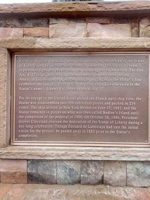
In 1865, Frenchman Édouard de Laboulaye proposed the idea of presenting a monumental gift from the people of France to the people of the United States. A prominent political thinker in his time, Laboulaye had spent much of his political career . . . — — Map (db m214431) HM
Near East 2nd Street, 0.1 miles east of North Kinsley Avenue.
The Little Colorado River and its tributaries supplied a vital water source to the area's earliest inhabitants and travelers. The watershed sustained the nearby Homol'ovi villages of the Ancestral Puebloans. A passable ford across the river allowed . . . — — Map (db m209669) HM
Near East 2nd Street, 0.1 miles east of North Kinsley Avenue.
In 1863, the United States government created the Arizona Territory from land it acquired during the Mexican-American War and the 1848 Treaty of Guadalupe-Hidalgo. Its northern region remained isolated and undeveloped until the railroad arrived. . . . — — Map (db m209689) HM
On Dixon Road (State Highway 338), on the right when traveling west.
During the nineteenth century, waves of German-speaking immigrants settled in Pulaski County. Establishing themselves here as early as 1833, these families had a significant impact on the development of the area through their work as farmers, . . . — — Map (db m220389) HM
On Park Street east of Pacific Avenue, on the right when traveling east.
Traces of Alameda Japantown
Opening up shops on Park Street
Traces of a small close-knit Japanese community remain, yet little is known of the Japantown that once thrived in Alameda. At the turn of the 20th century, Issei, first generation . . . — — Map (db m220123) HM
On City Center Drive near 2nd Street, on the right when traveling north.
Near this site, an Ohlone man traveling along a well-worn path encountered a group of armed men riding large four-legged beasts. The man, having never seen such men or horses, was startled. To show that he would not resist or threaten them, he lay . . . — — Map (db m207584) HM
Near Coloma Road (California Route 49) north of Mt Murphy Road.
In the years leading up to the Gold Rush, life changed dramatically for the Nisenan who called this valley home.
Cullumah
To the Nisenan, “Cullumah” was home. For generations, they thrived in the valley and mountains, building large . . . — — Map (db m214607) HM
On Monument Road (California Route 153) at Marshall Park Way on Monument Road.
Panel One:
New Jersey-born James Wilson Marshall came to John Sutter’s fort at Sacramento in July 1845, just a year before the American conquest of California. Trained as a carpenter and wheelwright by his father, Marshall quickly found . . . — — Map (db m215533) HM
Near Coloma Road (California Route 49) north of Mt Murphy Road.
Caught up in the frenzied news about the gold discovery, thousand of gold seekers from all corners of the world flooded into Coloma.
Fortune Seekers
California’s gold fields offered boundless opportunity and the hop of a brighter future. . . . — — Map (db m214879) HM
On Chester Avenue, on the left when traveling north.
Basque immigrants from the Pyrenees mountains of France and Spain were drawn to California by the Gold Rush. They found providing the miners with lamb and wool more profitable than digging for gold.
Young Basque men would follow their sheep . . . — — Map (db m237371) HM
The search for freedom and opportunities brings people to America. California has been a primary Pacific Coast destination since the 1800s. Between 1910 and 1940, about one million people from 80 countries were processed through the Angel Island . . . — — Map (db m203479) HM
On 3rd Avenue at Nelander Road, on the right when traveling west on 3rd Avenue.
Portuguese people from the Azores, as well as mainland Portugal, have a long and honored history in California. The first Europeans to land on the West Coast of the new world were Portuguese. Joao Rodrigues Cabrilho explored the coast in 1542 and . . . — — Map (db m243829) HM
On West Street near Sycamore Street, on the right when traveling north.
This house was built in 1857 by Mr. Geo. Hansen the promoter of that little colony of Germans who founded what is now the City of Anaheim, and originally stood on N. Los Angeles St. between Chartres & Cypress Sts.
The building was a gift . . . — — Map (db m241957) HM
In 1857, the Whitney’s arrival in Rocklin signaled the start of the Spring Valley Ranch. In the early 1900’s another important chapter of Rocklin’s agricultural history began with the arrival of Japanese and Spanish immigrants.
Both the . . . — — Map (db m243176) HM
From the native Ohlone and Miwok peoples’ tule reed canoes to today’s immense cargo ships, vessels have plied San Francisco Bay for many centuries.
In 1775, the Spanish ship San Carlos sailed through the Golden Gate to become the . . . — — Map (db m210704) HM
On Cabrillo Highway (State Highway 1) at 1st Street, on the right when traveling south on Cabrillo Highway.
Remembering the First People of Montara
Native Americans tell us they lived in their homelands since the creator placed them here. Archaeology confirms their presence for over 12,000 years. Over time they had to meet the challenges of changing . . . — — Map (db m229651) HM
Spain claimed Alta California after its conquest of Mexico (1519-1521) When reports of British and Russian encroachment in Northern California began to circulate in the 1760s, Spain expanded its colonial settlements to defend the California . . . — — Map (db m206740) HM
The discovery of gold at Sutter’s Fort in 1848 ushered in a period of rapid change in California as thousands of immigrants flooded into the state and the non-native population grew from 20,000 to 100,000 in one year. Mexico ceded California to . . . — — Map (db m206644) HM
Near Gourmet Alley south of 5th Street when traveling east.
Settlers from many countries came to Gilroy and brought their traditions and skills with them, contributing to Gilroy’s growth and vitality.
Germans Adam Riehl founded Gilroy Brewery and was one of Gilroy’s early City Mayors.
The . . . — — Map (db m218874) HM
Near Casa de Fruta Parkway near Pacheco Pass Highway (California Route 152).
California had an ancient system of Paths made by migrating herd as they searched for food and salt. Native Americans later used these trails to hunt, gather, and trade for survival. European colonists improved these roads as they settled here. The . . . — — Map (db m209016) HM
Near Monterey Highway south of Wright Avenue, on the right when traveling north.
Born in Wexford, Ireland, immigrated to Canada and in 1851 married Bernard Murphy in Quebec. Following his father, Martin Murphy Sr., the couple moved to California. She was widowed when there was a boiler explosion on the steamboat “Jenny Lind” . . . — — Map (db m213067) HM
Italian immigrants came to Morgan Hill in the years of the great Mediterranean migration to the United States between 1880-1930. Their commitment to family, strong work ethic and passion to succeed laid the cultural foundation for a strong agrarian . . . — — Map (db m213167) HM
Near Phelan Avenue east of Senter Road, on the left when traveling east.
The Vietnam War (1964-75) was America's longest war. For the Vietnamese, the war had begun in 1945 with the fight for independence from French colonial rule. In that struggle, the U.S. supported the French forces.
In 1975, South Vietnam's . . . — — Map (db m231601) HM
Near Old Winery Road east of Lovall Valley Road, on the left when traveling east.
Marker One:
Hidden within our maze are several private spaces; you may walk along our circuitous paths to find them. Inside these private spaces are signposts describing the astonishing life and journeys of Count Agoston Haraszthy, who . . . — — Map (db m231511) HM
On 19th Street at Larimer Street, on the right when traveling west on 19th Street.
A native of Toyama-ken, Japan, the Rev. Tamai came to Denver in June of 1930. He devoted the rest of his life - 53 years - to the spiritual, cultural and social needs of Buddhists in Colorado, Wyoming, Nebraska, Montana, Kansas, Oklahoma, Texas . . . — — Map (db m231831) HM
Discovery of gold in the Rocky Mountains in 1859 lured thousands of prospectors to the area eventually known as the Colorado Territory. This first wave of fortune seekers triggered the development of farms, ranches, businesses, and railroads . . . — — Map (db m222040) HM
On Deer Hill Avenue at West Street, on the right on Deer Hill Avenue.
The potato famine of 1846-1851 brought large numbers of Irish immigrants to town. Many purchased homes in the Town Hill neighborhood and St. Peter Church became a focal point for the community.
Germans immigrants were the first major group . . . — — Map (db m71353) HM
On Deer Hill Avenue at West Street, on the right when traveling north on Deer Hill Avenue.
The start of the 20th century saw a continual influx of newcomers to Danbury. A religious census taken in 1916 showed that 27 nationalities and 20 creeds were represented among the 22,533 residents of the town.
The 1910 census shows that a . . . — — Map (db m71473) HM
Near Myrtle Avenue, 0.1 miles north of Avery Place, on the right when traveling north.
Indigenous people frequented this area for thousands of years before the arrival of Europeans in the 17th century. In 1637, native Paugussets were driven away after the Great Swamp Fight between the larger Pequot tribe and European colonizers. In . . . — — Map (db m226768) HM
On Main Street north of Mather Street, on the left when traveling north.
Between 1863 and 1865, nearly 1,700 men of color enlisted in the 29th Volunteer Infantry Regiment, Connecticut's first non-white military unit. The recruits came from a variety of racial and ethnic origins and professional backgrounds. A . . . — — Map (db m230467) HM
On Main Street north of St. Monica's Avenue, on the right when traveling south.
Born in St. Andrew, Jamaica, he immigrated to Connecticut in 1951, where he opened a real estate and insurance company.
Elected to Hartford's city council in 1965, he battled to assist low-income families in purchasing homes for eight years. . . . — — Map (db m230481) HM
Near Connecticut Route 140 north of Canal Bank Road, on the right when traveling west.
More than 400 Irish immigrants came
to this area between 1827 and 1829 to
build the canal next to where this
park now stands. These brave people
lived in makeshift camps and worked
dawn until dusk in hard and dangerous
conditions to build a . . . — — Map (db m208597) HM
On Chapel Street at College Street, on the left when traveling east on Chapel Street.
In July of 1865 Pierre L'allement left his native France for America with the makings of a primitive iron bicycle in tow. That fall the 22-year-old mechanic settled in Ansonia about 12 miles west of here. The following April he rode his . . . — — Map (db m227297) HM
On Bank Street at Shaw Street, on the right when traveling east on Bank Street.
Given by the Italian American Community
and its Friends to the City of New London
in Memory of Those who came to America
to Fulfill Their Hopes and Dreams
May 3, 1987 — — Map (db m217034) HM
On Young Street, on the right when traveling south.
History (circa 1657) reflects that two hundred Italians from the Piedmont region may have immigrated to New Amstel (New Castle) via Holland and New Amsterdam (New York) little is known of his group, Not until the late nineteenth century did . . . — — Map (db m246130) HM
On Young Street, on the right when traveling south.
This monument is dedicated to the immigrants who came to New Castle from Italy starting in the late 1890s. They came primarily from the Abruzzo Region which is located on the Adriatic east from Rome. Residing for the most part on the west side of . . . — — Map (db m246127) HM
Near South Old Baltimore Pike east of Whittaker Road, on the right when traveling west.
Could it be …
1. a natural hill that formed millions of years ago?
2. a Native American burial mound?
3. a spoils pile from iron mining?
4. an abandoned charcoal furnace or collier's hut used by Abbington Iron Works? . . . — — Map (db m238414) HM
Near Stadium Drive south of West 18th Street, on the right when traveling south.
In the human experience, nothing has the power to transcend political and cultural boundaries quite like sport. On September 10, 1962, Armando "Tantor" Hidalgo '63, one of the 21 Cuban emigres that attended Salesianum from 1960-64, took the field . . . — — Map (db m217914) HM
On Hagley Creek Road at Stone Block Row, on the left when traveling north on Hagley Creek Road.
Located at this site on land purchased by French immigrant Elueuthere Irenee du Pont in 1802, the du Pont Powder Mills manufactured black powder at three sites along the Brandywine Creek north of Wilmington. E.I. du Pont de Nemours & Company . . . — — Map (db m240854) HM
On Blacksmith Hill Road, on the right when traveling west.
The foremen of the Hagley Yard and their families lived in this house for more than 50 years, following its construction by the company in 1846. John Stewart and his family were photographed in front of the house in 1885, the year he succeeded . . . — — Map (db m231912) HM
On South Harrison Street south of Linden Street, on the left when traveling south.
As the first century of our parish and the second millenium of our Catholic faith draw to a close we dedicate this bell which called the faithful to prayer for eight decades to our immigrant fathers and mothers who founded St. Hedwig . . . — — Map (db m217935) HM
On South Harrison Street south of Linden Street, on the left when traveling south.
St. Hedwig's R.C. Church
has been placed on the
National Register
of
Historic Places
November 12, 1982
Very Rev. Thomas F. Gardocki, Pastor
— — Map (db m196475) HM
On West 9th Street at North Dupont Street, on the left when traveling east on West 9th Street.
By the late 1800s, the opportunities offered by Wilmington’s expanding economy made it a desirable destination for persons from Italy seeking freedom and prosperity. Settlement accelerated in the early 20th century, and in 1924, the Bishop of . . . — — Map (db m145724) HM
On H Street Northeast at 13th Street Northeast, on the right when traveling east on H Street Northeast.
The small scale and low rents of H Street's oldest buildings have lured waves of immigrant entrepreneurs since the buildings were new in the 1880s. By 1930, alongside Greek, Italian, Irish, and other immigrant-owned shops, at least 75 . . . — — Map (db m71690) HM
On Maryland Avenue Northeast at G Street Northeast, on the right when traveling west on Maryland Avenue Northeast.
Maryland Avenue in the 1930s was home to immigrants from around the Mediterranean. Evelyn Kogok Hier grew up at 1328 Maryland Avenue. She remembered her next-door neighbor, the Right Reverend Ayoub (Job) Salloom, hosting after-church gatherings . . . — — Map (db m152471) HM
On F Street Northeast at 2nd Street Northeast, on the right when traveling east on F Street Northeast.
This is the western edge of what once was the rough, working-class Swampoodle neighborhood.
In the early days the marshy Tiber Creek ran between what are now North Capitol and First Streets, NE. Legend has it that lingering rain puddles . . . — — Map (db m130581) HM
On Park Road Northwest at 16th Street Northwest, on the right when traveling west on Park Road Northwest.
Low cost housing in Mount Pleasant in the decades following World War II made it an ideal place for immigrants to the area. Refugees fleeing World War II and the Cold War in Eastern Europe were the first group to arrive. A small Czech community . . . — — Map (db m130866) HM
On H Street Northwest west of 18th Street Northwest, on the left when traveling east.
"I am interested in how interactivity and play help us understand how we relate to one another. I create disarmingly fun experiences allowing people to let down their boundaries and connect. By expressing my ideas through . . . — — Map (db m223817) HM
On 18th Street Northwest at Newton Street Northwest on 18th Street Northwest.
Just like Mount Pleasant, Bancroft School is known for its ethnic and racial diversity. "at one of the spring fairs in the early 1970s, we asked people to bring native dishes, and I bought 27 little flags to mark the food," parent Gloria . . . — — Map (db m130872) HM
On 7th Street Northwest near L Street Northwest, on the left when traveling north.
Roots of Saint Sophia Greek Orthodox Cathedral
In 1904 members of Washington, DC's "Greek Colony" — mostly recently arrived immigrant men — held the city's first Greek Orthodox church service above a warehouse on Indiana . . . — — Map (db m130901) HM
On Georgia Avenue Northwest (U.S. 29) at Kenyon Street Northwest, on the right when traveling south on Georgia Avenue Northwest. Reported missing.
"Innumerable colored Chinese lanterns ... shedding that dim uncertain light which is the delight of lovers and the poetry of beer drinking"
— Washington Post, June 1879
Back when this area was open . . . — — Map (db m99221) HM
On Georgia Avenue Northwest (U.S. 29) at Morton Street Northwest, on the right when traveling south on Georgia Avenue Northwest.
Caribbean immigrants discovered this stretch of Georgia Avenue in the 1940s, bringing island culture along with jerk chicken, curry, and coco bread. Many, like Eric Williams, who later led Trinidad and Tobago to independence in 1962, came to . . . — — Map (db m130769) HM
On Kennedy Street Northwest just west of 4th Street Northwest, on the right when traveling east.
This mural created by Shirien Damra and United We Dream commemorates the very first Immigrant Day of Resilience on April 15, 2021.
On this day, we honor Edder, Joella, Satsuki, and the millions of resilient immigrants in the United States . . . — — Map (db m201675) HM
On Sheridan Circle Northwest south of Massachusetts Avenue Northwest, on the left when traveling north.
서재필 선생
Philip Jaisohn
1864 - 1951
The First Korean American
Pioneer for the Korean Independence and Democracy
Philip Jaisohn loved his native land, Korea
Shook it from its . . . — — Map (db m223330) HM
On 12th Street Northwest just south of Constitution Avenue Northwest (U.S. 1/50), on the right when traveling south.
Deer's Tongue lettuce was brought to North America by English settlers in the mid-1700s. Because the leaves are delicate, they are not distributed commercially. It is best to grow this lettuce variety in a backyard garden or small farm. — — Map (db m211416) HM
On Constitution Avenue Northwest (U.S. 50) at 16th Street Northwest on Constitution Avenue Northwest.
The German-American Friendship Garden
1683 - 1983
commemorates 300 years of German immigration and contributions to America and symbolizes the friendship between the German and American people — — Map (db m234006) HM
Near E Street Southeast at Potomac Avenue Southeast, on the right when traveling east.
Established in 1836 by hotelier John Gadsby, this structure was built to house many members of his family. An immigrant from England, Gadsby started his career in Alexandria in 1795. His reputation for fine hospitality was sealed at the City . . . — — Map (db m211921) HM
On 6th Street Southwest at Maine Avenue Southwest, on the right when traveling south on 6th Street Southwest.
Emerging from master planner Pierre L'Enfant's District Plan completed in 1791, Southwest D.C. began largely as an industrial shipyard, with fishermen selling directly off their boats until the Municipal Fish Market was established. In the years . . . — — Map (db m213299) HM
On Florida Avenue (Business U.S. 41) north of East Emily Street, on the right when traveling north.
The advent of the cigar industry in the late 1890’s ushered in an era of significant growth for Tampa which included many Catholic immigrants from Spain, Cuba, and Sicily as well as Catholic families who relocated from other parts of the U.S. This . . . — — Map (db m238387) HM
On North Pierce Street at East Madison Street, on the left when traveling south on North Pierce Street.
Born in West Tampa in 1938 to immigrants from Spain, Judge E.J. Salcines is widely admired for his professionalism and leadership in the administration of justice spanning almost fifty-five years. A graduate of Florida Southern College and South . . . — — Map (db m215682) HM
Near Northeast 3rd Street just west of Northeast Sanchez Avenue, on the right when traveling west.
Marti City, the center of Ocala’s tobacco industry, was a Cuban community of cigar makers, located 2 miles S.S.W. of this park. The Cubans worked with tobacco leaves that came from Cuba to Ocala through Jacksonville. Twenty cigar factories were . . . — — Map (db m212100) HM
Cuban Missile Crisis
Following the discovery of Russian nuclear missile installations in Cuba on October 15, 1962, large numbers of military troops and aircraft began arriving in Key West while destroyers and submarines in the harbor . . . — — Map (db m224166) HM WM
Near Wall Street at Tift’s Alley, on the left when traveling north.
In 1904, the beneficencia Cubana was organized for work among the Key West Cuban poor. In December, 1910, Maria Gutsens, Mrs Blanca Ferriol de Perez, Mrs. Carlotta Cenarro de Alayeto, Mrs. Maria Manas de Betancourt, Mrs. Esperanza La Fe, Mrs. . . . — — Map (db m223607) HM
On Whitehead Street at Greene Street, on the left when traveling north on Whitehead Street.
Arrived, Key West, August 3, 2015
21 feet × 7 feet. Steel and Wood
The Mariana landed in Key West with 23 men and one woman on board. It had taken just over 24 hours to make the 111 mile voyage from Cárdenas, Cuba. Empty 55-gallon . . . — — Map (db m245831) HM
Near Quay Road at Butler Boulevard, on the right when traveling south.
This 327 foot long, 6,200 hp cutter with a crew of 300 served in World War II, Vietnam, and the Korean war. The Ingham received a record 35 awards and was the most decorated vessel of its time. During it's service December 15, 1942, the Ingham . . . — — Map (db m222494) HM WM
On East Tarpon Avenue east of Hibiscus Street, on the left when traveling east.
This one-part masonry vernacular commercial building is the home of one of Tarpon Springs’ oldest businesses, Faklis Department Store & Show Repair, which began in 1912 as a shoe repair shop. Vasile Faklis, who started the business, came to Tarpon . . . — — Map (db m216602) HM
On Cross Street at Athens Street, on the right when traveling north on Cross Street.
Side 1
In 2014, Tarpon Springs' Greektown was listed as a Historic District and Traditional Cultural Property on the National Register of Historic Places for its unique ethnic heritage and maritime character. Greektown is bounded by the Anclote . . . — — Map (db m215070) HM
On Walker Street east of 6th Street, on the right when traveling east.
The second half of the nineteenth century saw increased Chinese immigration to
the United States to meet the needs of large-scale labor projects. In 1873, Chinese
laborers were contracted to expand the Augusta Canal. The Chinese Exclusion . . . — — Map (db m235779) HM
Historien Om
[the story of]
The story of Andersonville begins as a cherry orchard In the 1850s and evolves throughout the years, adding several layers of identity: first as a Swedish settlement on the outskirts of . . . — — Map (db m235738) HM
On West Exchange Avenue east of South Peoria Street, on the left when traveling east.
[Front of the marker:]
The Union Stock Yard and Transit Company, Chicago's legendary livestock market and slaughterhouse, opened at this site on Christmas Day, 1865. Here, 320 acres of swampland lying between Pershing Avenue, Halsted Street, 47th . . . — — Map (db m244189) HM
On North Boulevard, on the right when traveling west.
Knonawen
The Potawatomi word for connected (the act of talking to others)
La palabra Potawatomi para la conexión (el acto de platicar con otros)
A Crossroads and Gathering Place
For thousands of years, Native people . . . — — Map (db m242495) HM
On North Clark Street near West La Salle Drive (Illinois Route 64), on the right when traveling north.
[Text on front side:]
Wizhgéndëmowen
The Potawatomi word for resilient (the act of having strong thoughts)
La palabra potawatomi para la resistencia (el acto de mantener pensamientos fuertes)
Chicago in Ashes, Chicago Reborn
The . . . — — Map (db m242487) HM
On North Leavitt Street at West Cortez Street, on the right when traveling south on North Leavitt Street.
This well-preserved collection of workers cottages, single-family houses, Chicago-style flat buildings, and small apartments form a distinctive residential streetscape that tells the story of German, Polish, and, ultimately, Ukrainian immigrants who . . . — — Map (db m234579) HM
On West Cortez Street near North Oakley Boulevard.
This well-preserved collection of workers cottages, single-family houses, Chicago-style flat buildings, and small apartments form a distinctive residential streetscape that tells the story of German, Polish, and, ultimately, Ukrainian immigrants who . . . — — Map (db m234581) HM
On West Evergreen Avenue at North Hoyne Avenue, on the left when traveling east on West Evergreen Avenue.
Featuring a mix of elaborate residences built by affluent residents and more modest homes typical of the period, this community of German, Eastern European, and Scandinavian immigrants was home to merchants and labor activists alike in the late 19th . . . — — Map (db m233603) HM
On West 22nd Place at 57th Avenue, on the left when traveling west on West 22nd Place.
Named to honor the first President of an independent Czechoslovakia, the Thomas G. Masaryk Czech School opened at this site amidst elaborate ceremonies on September 4, 1921. It was established by the Freethinkers Bohemian School Association, a group . . . — — Map (db m245073) HM
On 57th Avenue south of 22nd Place, on the right when traveling south.
Named to honor the first President of an independent Czechoslovakia, the Thomas G. Masaryk Czech School opened at this site amidst elaborate ceremonies on September 4, 1921. It was established by the Freethinkers Bohemian School Association, a group . . . — — Map (db m245074) HM
On 24th Street west of 53rd Avenue, on the right when traveling east.
Mary Queen of Heaven Parish was founded in 1911 when more than 100 families of Czech descent living in the middle of Cicero petitioned the Archdiocese of Chicago for a new church.
A building on the northwest corner of 24th Place and 53rd Avenue . . . — — Map (db m245075) HM
On Tripp Avenue, 0.2 miles south of Roosevelt Road, on the right when traveling south.
[South-facing side, etched into the stone:]
Born Feb. 5, 1896, Alachata,
Asia Minor.
Killed in action near
Belleau Woods, France
July 18, 1918.
Pvt. 1st Cl. Co. H 103rd Inf.
26th Div. U.S. Army A.E.F.
Posthumously awarded . . . — — Map (db m239679) WM
We are Assyrians
In God we trust
Lachen — Hormis
This memorial is erected to the greater and honor of God and in remembrance of the descendants of the great Assyrian and Babylonian Empires, known to the world as the
Garden of Eden . . . — — Map (db m245888) HM
On North Clear Lane, 1.5 miles east of North Campground Lane, on the right when traveling east.
The Atkinson Cemetery was established March 11, 1875, by James Atkinson, who granted the land as a community burial ground. The first recorded burial (1843) was of Sarah A. Short, daughter of Thomas Jefferson and Martha "Patsy" (Maddux) Short. The . . . — — Map (db m236731) HM
On 27th Street at Delmar Avenue, on the right when traveling north on 27th Street.
Granite City grew up a mill town, drawing its expanding population from the flood of Central European immigrants who came to this new land with not much more than their heritage and optimism, in search of freedom and opportunity.
Two German . . . — — Map (db m205771) HM
On North Main Street south of First Street, on the left when traveling south.
Colonel William R. Morrison
One of Waterloo's most renowned and distinguished citizens was Colonel William R. Morrison, to whom the city owes its library.
The library building at the corner of Library and Park Streets was Colonel . . . — — Map (db m219967) HM
On North Main Street at West 1st Street, on the right when traveling north on North Main Street.
St. Paul United Church of Christ, of Waterloo, Illinois, had its beginning in 1846, in response to the formation of new denomination in Europe…a merger of many churches of German Reformed and Lutheran origin into the United Evangelical Church of . . . — — Map (db m220354) HM
On North Main Street south of First Street, on the left when traveling south.
The first French people came to Illinois during the seventeenth century because of political instability in France. The settlers took a trail from Kaskaskia to Cahokia called the "Hill Trail" Along this trail, just south of Waterloo, is a spring . . . — — Map (db m219731) HM
On North Main Street south of First Street, on the left when traveling south.
The Moore family left a distinguished mark on Waterloo's history.
Some time after settlement at Bellefontaine had been made, Captain James Moore, having established to some degree amicable relations with the Indians, took steps toward . . . — — Map (db m219950) HM
On Main Street just east of Henry Street (State Road 155), on the right when traveling east.
The historic village of Prairie du Rocher was established in 1722 by French settlers. It was named Prairie du Rocher, which means "Prairie of the Rocks", referencing the bluffs that surround the area. This area was an ideal place to settle due to . . . — — Map (db m224238) HM
On West Main Street at North Illinois Street (Illinois Route 159), on the right when traveling west on West Main Street.
Born in Frankfurt am Main, Germany, Bunsen fled to St. Clair County in 1834 after participating in a failed revolt. He farmed with other Latin Farmers and taught school. He was elected a delegate to the Illinois Constitutional Convention of 1847. . . . — — Map (db m208519) HM
On Mitchell Street north of East Looking Glass Street, on the right when traveling north.
Born in Angelbachtal, Baden-Wurttemberg in present-day Germany, Hecker studied law at the University of Heidelberg.
Hecker was one of the leaders who championed for democratic reforms in the 1848 uprisings in Germany. Like many other . . . — — Map (db m228249) HM
On 1st Street at 11th Avenue, on the right when traveling south on 1st Street.
Dutch culture is alive and well in Fulton. Fulton's Dutch heritage dates to its earliest days and the arrival of the first Dutch settlers.
The First Arrivals
In 1856, Thomas Smith became the first of many Dutch to settle in Fulton. . . . — — Map (db m230369) HM
On Columbia Street at Illinois Route 53, on the left when traveling east on Columbia Street.
George Kiser, an African-American, moved to Joliet from Missouri in the early 1900s. A laborer at the Joliet Iron Works, he worked in noisy, hot and dangerous conditions. The mill employed workers from all over the world - migrants from the south . . . — — Map (db m158086) HM
On West Center Street east of Lake Street, on the left when traveling east.
1830's – Ger. immigrants began setting in Lawrenceburgh.
1839 – Congregation formed. Like many other early church groups they met in the old Methodist Episcopal Meeting House erected in 1821 on Walnut Street where the Liedertafel Hall now . . . — — Map (db m222851) HM
On Prairie Street at Chapman Avenue, on the right when traveling north on Prairie Street.
Elkhart became a major center for the Mennonite church after John and Salome Funk moved here from Chicago in 1867. He was founding pastor of Prairie Street Mennonite Church at this location in 1871. His Mennonite Publishing Company connected . . . — — Map (db m236149) HM
On East 3rd Street at St. Michaels Avenue, on the right when traveling east on East 3rd Street.
Madison's history is filled with a wide variety of ethnic pioneers and settlers, including Jewish, Irish, German, French and African Americans, qualifying it as a true American melting pot. The first census of America taken in 1790 revealed that 77% . . . — — Map (db m206728) HM
On North Meridian Street north of 9th Street, on the right when traveling south.
This property
Independent
Turnverein
has been placed on the
National Register
of Historic Places
by the United States
Department of the Interior
— — Map (db m132865) HM
Near Downtown Canal Walk at North Blackford Street, on the left when traveling east.
Romanians came to Indiana in the early 1900s in search of a better life. Attracted by industrial jobs, many joined other Eastern European immigrants and settled in nearby communities, working in packinghouses and factories. They preserved their . . . — — Map (db m238740) HM
Near North Blackford Street north of Indianapolis Cultural Trail, on the right when traveling north.
Switzerland County was settled in 1802 by Swiss colonists who came to this Ohio River area to cultivate grapes for wine-making. Authors Edward Eggleston, writer of "The Hoosier School-Master," and brother George, were born here. Vevay, the county . . . — — Map (db m238871) HM
Near North Blackford Street north of Indianapolis Cultural Trail, on the right when traveling north.
National Old Trail Road in Wayne County is marked by the 18-foot high Madonna of the Trail statue. The National Road was a primary route for immigration into Indiana and provided access to essential eastern markets for Hoosier companies. Two such . . . — — Map (db m238934) HM
583 entries matched your criteria. The first 100 are listed above. Next 100 ⊳