By Cosmos Mariner, August 8, 2021
Ponca Trail of Tears Marker
| On County Road 198, 0.1 miles east of L Street (524th Road), on the right when traveling east. |
| On Front Street (State Highway 14) just north of 10th Street, on the right when traveling north. |
| On Front Street (State Highway 14) just north of 10th Street, on the right when traveling north. |
| On Beaver Street (State Highway 39) at 4th Street, on the right when traveling west on Beaver Street. |
| On State Highway 2, 1 mile east of Ravenna Road (State Highway 68), on the right when traveling east. |
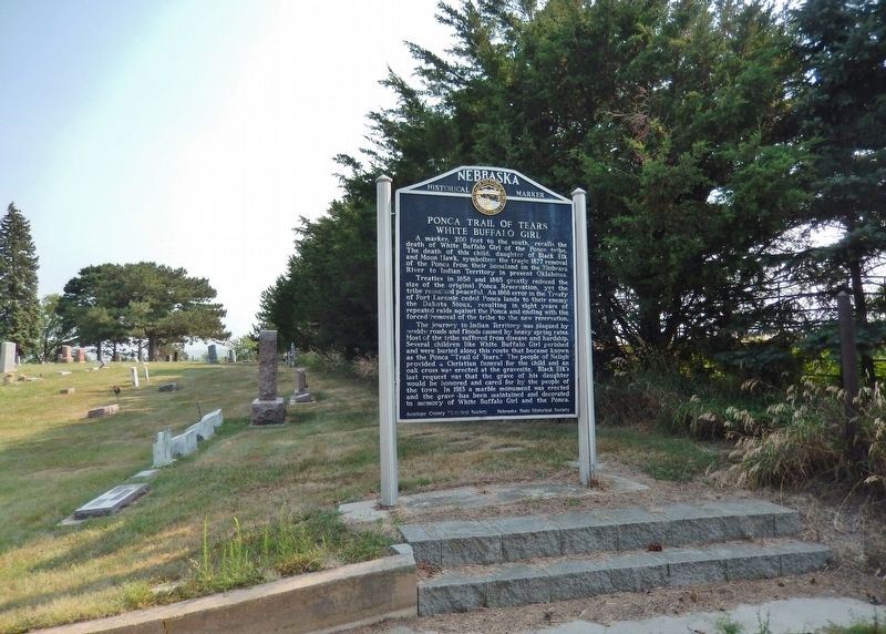
| Near U.S. 81, 1.5 miles south of 898th Rd.. |
| On U.S. 81, 1.5 miles south of 898th Rd. |
| Near U.S. 81, 1.5 miles south of 898th Rd.. |
| Near U.S. 81, 1.5 miles south of 898th Rd.. |
| On South Broadway Avenue north of East Franklin Street (State Highway 84), on the right when traveling north. |
| On Bodeman Park Drive just north of U.S. 6, on the right when traveling north. |
| On U.S. 20 at milepost 198, on the right when traveling west. |
| Near Interstate 80 (at milepost 61), 1.3 miles east of Upland Parkway (Alternate Interstate 80), on the right when traveling west. |
| On Fort Sidney Road, 0.1 miles north of Deaver Drive, on the left when traveling north. |
| On Road 11 (State Highway 15) 1.9 miles north of Lincoln Highway (U.S. 30), on the right when traveling north. |
| On Road South (State Highway 51) 0.4 miles west of State Route 16, on the right when traveling west. |
| Near U.S. 77, 0.9 miles north of 225th Street, on the right when traveling north. |
| On U.S. 20 just west of Knox Boulevard, on the right when traveling west. |
| On U.S. 385 at West 16th Street, on the left when traveling north on U.S. 385. |
| On Gold Rush Byway (U.S. 385) near Crazy Horse Memorial Highway (U.S. 20), on the left when traveling north. Reported missing. |
| On U.S. 385 near U.S. 20. |
| On Smiley Canyon Scenic Drive at Bridges to Buttes Byway (U.S. 20), on the right when traveling west on Smiley Canyon Scenic Drive. |
| Near Bridges to Buttes Byway (U.S. 20). |
| On Bridges to Buttes Byway (U.S. 20) 0.1 miles Soldier Creek Road, on the right when traveling south. |
| On McPhearson Street (U.S. 20) at State Highway 2, on the right when traveling east on McPhearson Street. |
| Near Bridges to Buttes Byway (U.S. 20) 0.2 miles south of Soldier Creek Road, on the left when traveling south. |
| On Old Smiley Scenic Road/Smiley Canyon Scenic Drive, 3 miles west of Bridges to Buttes Byway (U.S. 20), on the right when traveling west. |
| On Bridges to Buttes Highway (U.S. 20) near Soldier Creek Road. |
| Near Bridges to Buttes Byway (U.S. 20) 1.3 miles west of 1st Street, on the left when traveling west. |
| On 2nd Street at Main Street, on the right when traveling north on 2nd Street. |
| Near Bridges to Buttes Byway (U.S. 20) 0.2 miles south of Soldier Creek Road, on the left when traveling south. |
| On U.S. 20 at Betson Road, on the right when traveling east on U.S. 20. |
| On Old U.S. 20, 0.8 miles west of Whitney Lake Road, on the left when traveling west. |
| On Old U.S. 20, 0.6 miles west of Whitney Lake Road, on the left when traveling west. |
| Near Interstate 80 at milepost 226, on the right when traveling east. |
| On U.S. 30, 0.1 miles west of Road 430, on the right when traveling east. |
| On U.S. 30 at Road 446, on the right when traveling east on U.S. 30. |
| On County Highway 36 at County Highway 63.2, on the left when traveling south on County Highway 36. |
| On West 3rd Street (State Highway 26E) just east of North Nebraska Street, on the right when traveling west. |
| On Highway 26 E Spur, 0.6 miles north of Highland Road. |
| On John J Pershing Dr at Hummel Rd, on the left when traveling north on John J Pershing Dr. |
| Near Dodge Park Road, 0.6 miles east of John J. Pershing Dr.. |
| On Middle Street, on the left when traveling west. |
| On State Highway 18, 0.8 miles west of Wellington Street, on the left when traveling west. |
| On U.S. 6/34, 0.1 miles west of Center Avenue, on the right when traveling west. |
| On State Highway 8 east of 108th Road, on the right when traveling west. |
| Near U.S. 26, on the left when traveling south. |
| On South 8th Avenue just south of H Street, on the right when traveling north. |
| Near Dam Road (State Highway 96) 7 miles north of State Highway 91, on the left when traveling north. |
| On Nebraska Route 91/11, 0.3 miles east of Windy Hill Road, on the right when traveling east. |
| On Tech Ave. at U.S. 34 on Tech Ave.. |
| On Locust Street near 1st Street (U.S. 30), on the left when traveling south. |
| On Interstate 80 at milepost 316.5, on the right when traveling west. |
| On Tech Ave. at U.S. 34 on Tech Ave.. |
| On U.S. 34 near Old Highway 34, on the right when traveling east. |
| On 568th Avenue (Nebraska Route 15) 4 miles north of U.S. 136, on the left when traveling north. |
| Near West Main Street (State Highway 49A Spur) just west of South Third Street, on the left when traveling west. |
| On Lincoln Highway (U.S. 30) 5.4 miles east of U.S. 26, on the left when traveling east. |
| Near 521st Avenue at 890th Road, on the left when traveling north. |
| Near 521st Avenue at 890th Road, on the left when traveling north. |
| Near 521st Avenue at 890th Road, on the left when traveling north. |
| Near 521st Avenue at 890th Road, on the left when traveling north. |
| Near 521st Avenue at 890th Road, on the left when traveling north. |
| Near 521st Avenue at 890th Road, on the left when traveling north. |
| Near 521st Avenue at 890th Road, on the left when traveling north. |
| Near 521st Avenue at 890th Road, on the left when traveling north. |
| On State Highway 12 at 522 Avenue, on the right when traveling west on State Highway 12. |
| Near 521st Avenue at 890th Road, on the left when traveling north. |
| Near 521st Avenue at 890th Road, on the left when traveling north. |
| On South 14th Street just south of K Street, on the right when traveling south. |
| On South 14th Street just south of K Street, on the right when traveling south. |
| On U.S. 30 at South Jackson Road, on the left when traveling east on U.S. 30. |
| On Halligan Drive, 0.1 miles south of Platte Oasis Parkway, on the left when traveling south. |
| Near North Buffalo Bill Avenue, 0.8 miles north of Lincoln Highway (U.S. 30), on the right when traveling north. |
| Near North Buffalo Bill Avenue, 0.8 miles north of Lincoln Highway (U.S. 30), on the right when traveling north. |
| Near North Buffalo Bill Avenue, 0.8 miles north of Lincoln Highway (U.S. 30), on the right when traveling north. |
| On East Third Street at North Dewey Street, on the right when traveling east on East Third Street. |
| On 546th Avenue (State Highway 121) 1.1 miles south of Front Street (U.S. 275), on the right when traveling south. |
| Near South Park Street (State Highway 39) just south of Ewing Avenue, on the right when traveling south. |
| Near South Park Street (State Highway 39) just south of Ewing Avenue, on the right when traveling south. |
| Near East Webster Avenue at North Cottonwood Street, on the left when traveling east. |
| On Central Avenue (U.S. 136) near Half-Breed Road, on the right when traveling west. Reported missing. |
| Near Main Street just west of South 2nd Street, on the left when traveling west. |
| On State Highway 14, 1.6 miles north of State Highway 4, on the left when traveling north. |
| On 7th Street (Nebraska Route 8) just west of G Street, on the right when traveling west. |
| On Nebraska Route 67B Spur just west of Nebraska Route 50, on the left when traveling east. |
133 entries matched your criteria. The first 100 are listed above.
The final 33 ⊳