May 14, 2023
The Oahe Dam & Lake Marker (Reverse Side)
| On State Highway 1804, 1.8 miles west of Grey Goose Rd, on the left when traveling north. |
| On Highway 1804, 0.8 miles west of Grey Goose Rd. |
| On South Poplar Street, 0.2 miles south of West Missouri Avenue, on the left when traveling south. |
| On 2nd Street Southwest, 0.1 miles west of Dakota Avenue, on the right when traveling west. |
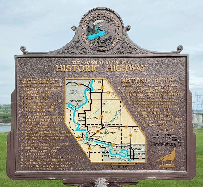
| On U.S. 81 at East Birch Street, on the right when traveling south on U.S. 81. |
| On U.S. 81 at East Birch Street, on the right when traveling south on U.S. 81. |
| On U.S. 14 west of 434th Avenue, on the right when traveling west. |
| On 3rd Street Southwest at Harvey Dunn Avenue Southwest, on the right when traveling east on 3rd Street Southwest. |
| On U.S. 81 at 220th Street (County Road 10), on the left when traveling north on U.S. 81. |
| On Territorial Road, 0.4 miles north of 234th Street (State Highway 236). Reported missing. |
| On Territorial Road just south of U.S. 81, on the right when traveling south. Reported missing. |
| On 233rd St. at 442nd Ave., on the right when traveling west on 233rd St.. |
| On Interstate 90, 1 mile west of Red Hill Road, on the right when traveling east. |
| On CanAm Highway (U.S. 85) north of U.S. 385, on the left when traveling north. |
| On U.S. 14A, 6 miles south of Business 90, on the left when traveling south. |
| On U.S. 18, 1 mile east of 482nd Avenue, on the right when traveling east. |
| Near 480th Avenue (County Highway 135) 0.2 miles south of 269th Street. |
| Near 480th Avenue (County Highway 135) 0.2 miles south of 269th Street (County Highway 102). |
| Near 480th Avenue (County Highway 135) 0.2 miles south of 269th Street (County Highway 102). |
| Near 480th Avenue (County Highway 135) north of 270th Street, on the right when traveling north. |
| Near 480th Avenue (County Highway 135) 0.2 miles south of 269th Street (County Highway 102), on the left when traveling south. |
| Near 480th Avenue (County Highway 135) 0.2 miles south of 269th Street (County Highway 102). |
| Near 480th Avenue (County Highway 135) 0.2 miles south of 269th Street (County Highway 102), on the right when traveling north. |
| Near 480th Avenue (County Highway 135) south of Trading Post Road. |
| Near 480th Avenue (County Road 135) north of 270th Street, on the right when traveling north. |
| Near 480th Avenue (County Highway 135) 0.2 miles south of 269th Street (County Highway 102). |
| Near an unnamed road, 0.4 miles east of 321st Avenue, on the right when traveling east. |
| On State Highway 47, 4 miles south of 248th Street (County Road 6), on the left when traveling south. |
| On Interstate 90 at milepost 221, on the right when traveling west. |
| On Route 10, 1 mile west of 450th Ave., on the right when traveling east. |
| On 119th Street (State Highway 10) 1.6 miles east of BIA Road (Road 3), on the right when traveling east. |
| On Interstate 90, 1.8 miles west of 441st Avenue (U.S. 81), on the right when traveling east. |
| On 1st Street East (U.S. 212) east of East 1st Avenue, on the right when traveling east. |
| On South Dakota Route 79. |
| On 206th Street (South Dakota Route 34) 0.2 miles west of 131st Street (South Dakota Route 79), on the left when traveling east. |
| On 206th Street (State Highway 34) near Custer Avenue, on the right when traveling west. Reported damaged. |
| On Junction Avenue at Harmon Street on Junction Avenue. |
| On 130th Avenue (South Dakota Route 79) at 201st Street, on the right when traveling north on 130th Avenue. |
| On Junction Avenue at Harmon Street on Junction Avenue. |
| On South Dakota Route 34 at Custer Avenue, on the left when traveling east on State Route 34. |
| On South Dakota Route 79. |
| On Junction Avenue at Harmon Street on Junction Avenue. |
| On Junction Avenue at Harmon Street on Junction Avenue. |
| Near Bear Butte State Park Drive, 1 mile north of U.S. 79, on the left when traveling north. |
| On South Splitrock Boulevard (State Highway 11) 0.4 miles south of South Sioux Boulevard, on the right when traveling south. |
| On South Splitrock Boulevard (State Highway 11) 0.4 miles south of South Sioux Boulevard, on the right when traveling south. |
| On South Splitrock Boulevard (State Highway 11) 0.4 miles south of South Sioux Boulevard, on the right when traveling south. |
| On 248th Street (County Road 110) at 461st Avenue (County Road 155), on the right when traveling west on 248th Street. |
| On West Indian Mound Place, on the right when traveling west. |
| On West Indian Mound Place, 0.1 miles west of South Kiwanis Avenue, on the right when traveling west. |
| On West Madison Street, 0.1 miles east of North Covell Avenue, on the right when traveling east. |
| On West Algonquin Street, 0.1 miles east of F Avenue North, on the right when traveling west. |
| Near South Marion Road, on the right when traveling south. |
| On West 22nd street, on the left when traveling west. |
| On W 17th Street, 0.1 miles west of S Phillips Ave, on the left when traveling west. |
| On W 8th Avenue, 0.1 miles west of S Duluth Avenue, on the left when traveling west. Reported permanently removed. |
| On West 8th Street west of North Duluth Avenue, on the right when traveling east. |
| Near North Cherapa Place south of East 6th Street. |
| On North Phillips Avenue, 0.1 miles north of East 8th Street, on the right when traveling north. |
| On North Phillips Avenue north of West 5th Street, on the right when traveling north. |
| On South Phillips Avenue north of West 10th Street (State Highway 42), on the right when traveling south. |
| Near East Falls Park Drive at North 2nd Avenue when traveling south. |
| Near East Falls Park Drive at North 2nd Avenue. |
| Near East Falls Park Drive at North 2nd Avenue when traveling south. |
| On Interstate 90, on the right when traveling west. |
| Near Interstate 90 at milepost 412.1,, 1.2 miles west of State Route 23, on the right when traveling west. |
| On 471st Avenue at 220th Street, on the right when traveling north on 471st Avenue. |
| On 235th Street (State Highway 34 at milepost 400) east of 466th Avenue, on the right when traveling west. |
| On 481st Avenue (State Highway 13) 0.5 miles north of 229th Street, on the right when traveling north. |
| On State Highway 13, 0.2 miles north of 229th Street, on the right when traveling north. |
| On 481st Avenue (State Highway 13) 0.2 miles south of 229th Street, on the right when traveling south. |
| On Flandreau Park Road, 0.3 miles north of 230th Street, on the right when traveling north. |
| On Water Street at East 2nd Avenue, on the left when traveling north on Water Street. |
| Near 481st Avenue (State Highway 13) 0.2 miles north of 229th Street, on the right when traveling north. |
| On Big Foot Trail (County Road 27) 5.9 miles north of County Road 28. Reported damaged. |
| On Big Foot Trail (SD 27). |
| On an unnamed extension off Big Foot Trail, 0.1 miles north of Big Foot Trail and Mouse Creek Road, in the median. |
| Near West Omaha Street just east of Canal Street, on the right when traveling west. |
| Near Interstate 90 at milepost 98 east of Base Line Road, on the right when traveling east. |
| Near Interstate 90 at milepost 100, on the right when traveling west. |
| On Interstate 990, 0.5 miles Wasta, on the right when traveling east. |
| On East Carr Street at First Avenue East, on the left when traveling east on East Carr Street. |
| On West Commercial Avenue east of South Platte Street, on the left when traveling east. |
| On U.S. 212 at 296th Avenue, on the right when traveling west on U.S. 212. |
| On 455th Avenue (State Highway 25) 0.4 miles south of 102nd Street, on the right when traveling south. |
| On 478th Avenue (State Highway 15) at 142nd Street, on the right when traveling north on 478th Avenue. |
| Near Interstate 29 at milepost 2, on the right when traveling south. |
| On U.S. 12, 0.8 miles west of 450th Ave., on the right when traveling east. |
| Near BIA 200, 1.8 miles west of Whipple Road (County Highway 34), on the left when traveling west. |
| Near 117th Street (Road BIA 8) 3.1 miles west of 455th Avenue (County Road 6), on the left when traveling west. |
| On 2nd Avenue East north of Maple Street East, on the right when traveling north. |
| On 478th Avenue (State Highway 127) at 102nd Street, on the right when traveling south on 478th Avenue. |
241 entries matched your criteria. Entries 101 through 200 are listed above.
⊲ Previous 100 —
The final 41 ⊳