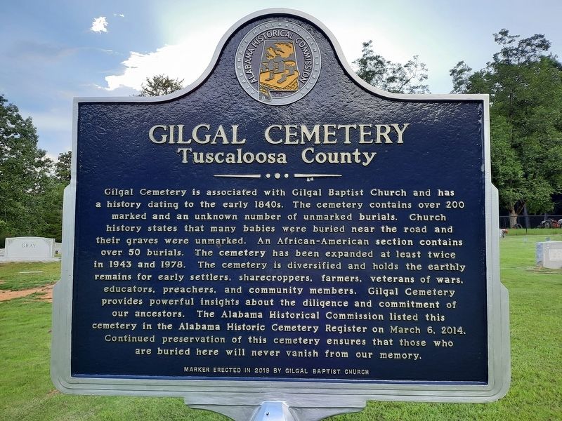
Gilgal Cemetery is associated with Gilgal Baptist Church and has a history dating to the early 1840s. The cemetery contains over 200 marked and an unknown number of unmarked burials. Church history states that many babies were buried near the road . . . — — Map (db m231528) HM
One of four historic cemeteries located on the campus of Bryce Hospital, Alabama's oldest mental health facility, this cemetery features at least thirty-seven marked graves, the earliest of which dates to 1892. There are an undetermined number of . . . — — Map (db m235525) HM
One of four historic cemeteries located on the campus of Bryce Hospital, Alabama's oldest mental health facility, this cemetery was established in 1922 and was closed for burials in 1953. It contains approximately 1550 burials mostly marked with . . . — — Map (db m40449) HM
One of four historic cemeteries located on the campus of Bryce Hospital, Alabama's oldest mental health facility, this cemetery was established in 1953 and is still in use. It contains approximately 500 burials mostly marked with simple, . . . — — Map (db m235677) HM
Dr. Peter Bryce, first superintendent of the Alabama Insane (Bryce) Hospital was a leading proponent of humane treatment for people who experience mental illness. Born March 5, 1834, in Columbia SC, Bryce entered the South Carolina Military Academy . . . — — Map (db m235505) HM
Evergreen Cemetery began as family plots for Tuscaloosa citizens in the mid-nineteenth century. An 1857 letter to the editor In the Tuscaloosa Independent Monitor described citizens' growing frustration with the maintenance of Greenwood . . . — — Map (db m203536) HM
Laid out in the original city plan, Greenwood is Tuscaloosa’ oldest surviving cemetery. It has been in continuous use since prior to 1820. The earliest marked grave is dated 1821.
Some of the ornate marble markers located in Greenwood were . . . — — Map (db m40392) HM
This is the oldest of four historic cemeteries located on the campus of Bryce Hospital, Alabama's oldest mental health facility. The first recorded burial dates to 1861. While only a few graves are currently marked, it is estimated that thousands of . . . — — Map (db m40450) HM
Buried near this plaque are Jack Rudolph and William “Boysey” Brown, two slaves owned by University of Alabama faculty, and William J. Crawford, a University student who died in 1844.
Rudolph was born in Africa about 1791 and died . . . — — Map (db m40389) HM
South Carolina-born Daniel Tubbs (17 Feb. 1794 - 25 Mar 1882) enlisted in the War of 1812 and fought in the final battle at New Orleans. Honorably discharged in Nashville on 20 Apr. 1815, he and his wife. Matilda Sanders. settled on this site . . . — — Map (db m153242) HM
Calvert Methodist Episcopal Church South first organized in
in a
community building used for a school. In 1889, Francis A. and
Edna Webb donated this property for a church, and the congregation
built this building in the same year. The church . . . — — Map (db m245524) HM
In Memoriam
From 1905 to 1916 at least 83 men died and 400 were injured in gold mining accidents in the Fairbanks area. Underground mining was dangerous during this pioneer era. Most died from cave-ins, falling down shafts, being struck by . . . — — Map (db m47383) HM
The following 72 Inupiat Eskimos are interred in this common grave. Pray, honor and remember these villagers, who lost their lives during the short span of five days, in the influenza pandemic, November 15-20, 1918.
Abeyorok, Mike, 26 • . . . — — Map (db m149930) HM
In 1878, this notorious outlaw gang clashed over dividing their loot. A heated gunfight occurred in the saddle of this hill and it is said that at least seven died. Here lie their last known remains. — — Map (db m36607) HM
Second cousin to famed "Texas John Slaughter", Peter Slaughter & his rough trailhands brought the first Texas cattle to the White Mountains c. 1881 and built his P Lazy S Ranch on the Black River. Pete is buried here with 3 sons & extended family. — — Map (db m228567) HM
This land was deeded to the City of Benson as a cemetery by the Pacific Improvement Company, the California based land company of the Southern Pacific Railroad, in March 1929.
Burial plots were sold to residents by the City of Benson and the . . . — — Map (db m48512) HM
The Post Cemetery predated the establishment of Fort Bowie, when soldiers of the California Column were interred here in 1862. The area was unfenced until 1878, when a four-foot adobe wall was erected to protect the graves from desecration by post . . . — — Map (db m68858) HM
On May 5, 1862, a Confederate foraging party rounding up cattle near the abandoned Butterfield Overland Mail Station battled a group of Apaches. The soldiers were members of Company A, Governor John R. Baylor's Regiment of Arizona Rangers, under the . . . — — Map (db m83149) HM
In 1895, seventeen-year-old William Walter Adams left Coleman County, Texas, to visit his older brother, Dave A. Adams, who was one of the first of the Adams family to settle in the Little Dragoon Mountains of Cochise County. "Will," soon decided . . . — — Map (db m216038) HM
The remains of this noted gunman and outlaw lie here. A teamster traveling from West Turkey Creek found the body sitting in the fork of a nearby oak tree with a bullet hole in the right temple.
A coroner's jury reported the death to be suicide, . . . — — Map (db m28365) HM
This cemetery
holds the remains of
18 California Volunteers who died
at Fort Lowell during the Civil War and a
Civil War Veteran of the U.S. Colored Troops.
Their graves are marked with a GAR star.
Sgt. John C. McQuade - Co.B, 2 Calif. . . . — — Map (db m33745) HM
Tombstone, Arizona dates to 1877, when prospector Ed Schieffelin discovered silver and named his first mine Tombstone. By 1879, a town had sprung up in a relatively flat area nearby. Gunslingers, gamblers, prospectors, Chinese laborers, and fancy . . . — — Map (db m220542) HM
This Tombstone Cemetery gives mute testimony to the hardships of Western frontier life. The people buried here were housewives, painted ladies, outlaws, gamblers, miners, business men and women, blacksmiths, cowboys and those "who died with their . . . — — Map (db m27926) HM
The son of a miner, Ed learned everything about prospecting from his father, except how to strike it rich! For twenty years, Ed prospected the west. He tried the "regular life," but after 18 months remarked: "No better off than I was prospecting, . . . — — Map (db m27933) HM
Buried here are the remains of Tom McLaury, Frank McLaury, Billy Clanton - killed in Earp Clanton battle Oct 26, 1881.
Dan Dowd, Red Sample, Bill DeLancy, Dan Kelly: Tex Howard hanged legally by Sheriff Ward for Bisbee massacre Mar 1884, John . . . — — Map (db m100173) HM
They came when only the brave dared come: They stayed where only the valiant could stay. Born in Sweden. Americans by choice - not by accident of birth, they loved their adopted country and served her well.
Neil
Served five years in the . . . — — Map (db m28368) HM
"Sacred to the memory of these pioneers, they came when only the
brave dared come: they stayed
where only the valiant could stay."
Lillian Erickson Riggs
Swedish immigrants, Neil and Emma Erickson married in 1887 and . . . — — Map (db m28366) HM
On June 30, 1956, a TWA Constellation and a United Airlines DC-7 collided over the Grand Canyon. The 123 passengers and crew members aboard both aircraft perished.
This site is a common burial and memorial to 66 of the 70 TWA passengers and . . . — — Map (db m154949) HM
Catastrophe can happen even in spectacular beauty. When technological achievements and human actions fail, disasters may happen.
On June 30, 1956, a United Airlines DC-7 and a TWA Super Constellation maneuvered around towering cumulus clouds on . . . — — Map (db m124533) HM
Veteran of the Civil War and for twenty years a leader of Scouts for the U.S. Army in Arizona Indian troubles. Was killed on this spot February 19th, 1907 by a rolling rock during construction of the Tonto Road. His body is buried in the cemetery at . . . — — Map (db m34114) HM
Thomas Bouse was born in Mendecino County, California and came here about 1889 as a prospector and built the first two rooms of his home. He ran a small store here. He brought his wife, Katherine, and infant daughter here in 1892. Three more . . . — — Map (db m29070) HM
This monument built to
perpetuate the memory of
the pioneers, trailblazers,
and adventurers that rest
in these unmarked graves.
(Arizona Highway Department, 1934)
Rededicated: April 27, 2003 (CY 6008)
By the Ancient and . . . — — Map (db m31188) HM
First used sometime after June 16, 1862. Some of Arizona's earliest pioneers, people of every race and moral persuasion, lie here in eternal peace. The last burial was on April 22, 1988. — — Map (db m31827) HM
This small plot of land was designated a cemetery by the Goodyear Tire and Rubber Company of Akron, Ohio. Goodyear owned and farmed the surrounding acreage from 1916 until 1943. Goodyear workers and their families are buried here. Local oral history . . . — — Map (db m34555) HM
Born August 23, 1839 – New Harford, New York
Died April 17, 1923 – Phoenix, Arizona
Buried Greenwood Cemetery
Murphy came to Arizona from Illinois in 1880, to build a section of the Atlantic and Pacific (Santa Fe) Railroad. In . . . — — Map (db m30433) HM
The 1897 Smurthwaite House is an excellent example of Shingle Style Architecture. It is one of fewer than one hundred 19th century buildings of this age left in Phoenix. It was donated to the City of Phoenix Park, Recreation and Library Department . . . — — Map (db m39414) HM
The first priest ordained in Arizona, Father Edouard Gerard, attended the Catholic people of Phoenix from Florence, Arizona, where he was the pastor of the Church of the Assumption from 1877 to 1885. For many years, Father Gerard was Vicar General . . . — — Map (db m27626) HM
"The markers in this memorial area honor veterans whose remains have not been recovered or identified, were buried at sea, donated to science or cremated and the ashes scattered." — — Map (db m102948) HM
Tempe's first cemetery, named for the Buttes in the background, was established before 1900. It was located on 80 acres of high ground because lower areas were waterlogged. Members of Tempe's best-known families lie here, along with victims of . . . — — Map (db m34556) HM
[Main Marker]Entombment of
George W. P. Hunt
Born 1859 Died 1934
Colorful Arizona pioneer and statesman. Member of various territorial legislatures. President, Arizona Constitutional Convention 1910. Elected Arizona's 1st, 2nd, . . . — — Map (db m30405) HM
This cemetery remains as the last vestige of the pioneer settlement of Hardyville founded in 1864 by William R Hardy, the town served as an important ferry crossing, steamboat landing, shipping point for area mines and as the Mohave County Seat . . . — — Map (db m29339) HM
March 24, 1876, Mormon colonization in Arizona began here with the establishment of Ballanger's Camp, later Brigham City, by Lot Smith, Jesse O. Ballanger, George Lake, William C. Allen and others sent from Utah by Brigham Young. They also . . . — — Map (db m96974) HM
Family Man
Church Leader
Defender of the Prophets
Colonizer
Friend of the Indians
Stockman
Noted Horseman
Defender of Liberty
In January of 1876, Lot Smith was called by President Brigham Young on a mission to captain one of four . . . — — Map (db m185335) HM
Answering the Church's Call
In January of 1876, Brigham Young, the President of the Church of Jesus Christ of Latter Day Saints, announced his plan to establish Mormon colonies in the Arizona Territory. In the months that followed, more than . . . — — Map (db m185328) HM
This monument marks the cemetery and vicinity of the site of Sunset, a Mormon pioneer settlement founded by Lot Smith in March, 1876. The settlers, part of a colonization group called from Utah to Arizona by Brigham Young, came by way of Lee's . . . — — Map (db m185080) HM
Pursuant to judgement rendered in the Superior Court of the State of Arizona, in and for the County of Pima, Case no. 30813, The bodies of persons buried in the Old Clarkston Cemetery which lay approximately 1700 feet northwest of this point, have . . . — — Map (db m82935) HM
Charles Debrille Poston, 1825-1902, often referred to as the "Father of Arizona", promoted territorial status for Arizona during President Lincoln's administration. Poston, motivated by silver mining interests lobbied for federal legislation to . . . — — Map (db m26661) HM
The Pinal Cemetery served the nearby mill town of Picketpost/Pinal (1876 to 1892), which processed the silver ore taken from the Silver King Mine. Resting here in a cross-section of people from the surrounding area: the first settlers, miners, mill . . . — — Map (db m73003) HM
Citizens Cemetery was founded in early June 1864 with the burial of Colorado legislator Joel Woods. Established on public land east of Prescott and southwest of Fort Whipple, the cemetery has been known at various times as “Town . . . — — Map (db m21668) HM
The first burial occurred on this site in 1918. Henry Elmer Cook established the cemetery in 1933 as part of his 160 acre homestead. Many members of Sedona pioneer families are buried here including the city's namesake, Sedona Schnebly. — — Map (db m94833) HM
In memory of
the inmates, who lost their life
while serving their sentence, at the
Arizona Territorial Prison at Yuma
Aldrete, Simon • Alejandra • Alveres, Thomas • Armbula, Tomas • Arnett, William • Arvizu, Gregorio • Baca, Antonio • . . . — — Map (db m51636) HM
Bayou Meto Cemetery was established in 1876 after Allen "Uncle Gip" Gibson donated one acre of land to the local community for use as a cemetery. Gibson, a former Union soldier, was an early settler of the Bayou Meto Community. A skilled . . . — — Map (db m178029) HM
Green Grove Cemetery got its official beginning when Martin and Minnie Buerkle sold two acres of property to the Trustees of Green Grove Cemetery Association in September of 1903. This cemetery was likely the first burial ground dedicated to serving . . . — — Map (db m234960) HM
The Mountain Home Cemetery began with the burial of an 11-month-old child, Willie Russell, in 1857. Willie was the son of County Judge John S. Russell. The lot was owned by Orrin L. Dodd, known as the “Father of Mountain Home,” before it was . . . — — Map (db m243005) HM
So called because steps were dug into the hill so settlers could reach the top.
Once existed two churches, a school and a cemetery. Area named and cemetery started about 1867. — — Map (db m90572) HM
Camp Jackson Confederate Gen. Ben McCulloch established
Camp Jackson in July 1861 before marching into
Missouri. After the Aug. 11 Battle of Oak Hills
he returned to Camp Jackson. The 4th Arkansas
Infantry Regiment, which formed Aug. 17, . . . — — Map (db m224988) HM
Soldiers who died at Camp Jackson in 1861
and buried here in unmarked graves
Calhoun Escopets – Co. A
Adolphus P. Williams - Pvt. • Francis C. Harbor - Pvt. • Benjamin F. Bearden - Pvt. • James W. Strong - Pvt. • John C. Farmer - Pvt. • . . . — — Map (db m225001) WM
James Miller Ingram was a captain in the Confederate 6th Provisional Cavalry Partisan Rangers. Years after the war ended, as a self-taught minister he went to preach at a church and was murdered - shot in the back by 19 year old John M. Stone. . . . — — Map (db m68790) HM
1.6 acres for the
purpose of establishing
a church & cemetery.
Donated by L.E. Mason
& Ann Mason (wife)
Deeded July 20, 1861.
Trustees;
Thomas Bingham
Samuel H. Johnson
John Mason — — Map (db m224875) HM
In early April 1857, a large wagon train known as the Fancher-Baker train left Caravan Spring (south of Harrison) and headed for California. They camped at this site en route to intercept the Cherokee trail at the Grand Saline in Indian territory. . . . — — Map (db m225245) HM
Pioneer burial ground on land homesteaded 1880 by James and Rachael McAtee Lamar. Recorded burials begin 1880 after founding of Eureka Springs. May 29, 1889, the 46-acre site deeded to Lodge No. 83 Independent Order of Odd Fellows which maintained . . . — — Map (db m225226) HM
When Judas, betrayer of Jesus, repented and returned the thirty pieces of silver, the chief priests refused them, then “took counsel and bought with them the Potter’s Field to bury strangers in”. Matthew 27:3-10 KJB thus began the tradition. Names . . . — — Map (db m229498) HM
In Memoriam Hyner Cemetery established in 1898 marks the site of those devout, courageous Italian immigrants who came to America in 1895 settling and working at Sunnyside Plantation and throughout the Delta area. They established schools, . . . — — Map (db m168476) HM
This home was built about the year 1848 for John H. Saunders and his wife Martha A. Pettit Saunders. During the Civil War engagement at Ditch Bayou in 1864 the house was used as a hospital for soldiers of both armies. A number of military dead were . . . — — Map (db m107737) HM
East & South of this point was
The Blakely Graveyard
in this first public burying
place of the community, the
early settlers were interred.
It remained in use until 1869
when it was closed to future
burials by the city council. . . . — — Map (db m200782) HM
Battle of Marks' Mills
On April 23, 1864, a Union force with 240 wagons left Camden to get supplies from Pine Bluff for Gen. Frederick Steele's army. Gen. James Fagan's Confederate cavalrymen ambushed them at Marks' Mills on April 25. . . . — — Map (db m121150) HM
John P. McCown was born Aug. 19, 1815, in Sevierville, Tenn. An 1840 graduate of West Point, he served in the Mexican and Seminole wars before resigning from the U.S. Army on May 17, 1861. McCown joined the Confederate army, rising to the rank of . . . — — Map (db m121139) HM
The last Confederate veteran living in Arkansas, William Murphy Loudermilk, is buried here in Keller’s Chapel Cemetery. Private Loudermilk, who was born Oct. 17, 1847, joined a North Carolina regiment in the Army of Tennessee at age 16 and fought at . . . — — Map (db m116195) HM
The Battle of Prairie Grove was a grim moment for the Confederate Army. This conflict severed all chances for the South to use Northwest Arkansas as a route to invade Missouri. The shattered and defeated soldiers retreated from Prairie Grove to Van . . . — — Map (db m96617) HM WM
Erected in memory of
our Confederate soldiers
from Ark., Tex., La., Mo., and
Indian territory,
who lost their lives in the
Battles of Oak Hill, Elk Horn,
and Prairie Grove. — — Map (db m96632) WM
Plaque Rohwer Relocation Center Memorial Cemetery Has Been Designated A National Historic Landmark This Site Possesses National Significance In Commemorating The History Of The United States of America 1992 . . . — — Map (db m167617) HM
Following is a partial list of persons who died and were buried at Cadron. They perished from cholera while being relocated by the Army in 1834. Graves were marked with native stones with no inscriptions. Some of the Indians had adopted . . . — — Map (db m96643) HM
Faulkner County had divided loyalties during the Civil War. Soon after the war started, Col. A.R. Witt helped organize several companies for the 10th Arkansas Infantry (C.S.). After fighting at Shiloh, the 10th was captured at Port Hudson, La. . . . — — Map (db m119987) HM
Many small towns once existed in the area now covered by Lake Ouachita. Settlers first came to the upper Ouachita River valley in the decades prior to the Civil War to establish homes, farms and businesses, creating communities such as Cedar Glades . . . — — Map (db m108929) HM
Presented by Arkansas Col. John Washington Chapter, National Society Colonial Dames, XVII Century, honoring War Veterans, Early Pioneers, 1998 — — Map (db m61770) HM WM
(Left Side)
True to their native soil. They gave their lives to a cause that was lost. Their survivors will never suffer their memory to perish.
(Right Side)
Erected by our citizens to the memory of the Confederate . . . — — Map (db m245989) WM
More than 19 companies formed in Hempstead County to fight for the Confederacy, starting with the "Hempstead Rifles," who mustered in on May 4, 1861. These local men served in the Confederate Congress - Grandison D. Royston and Rufus K. Charles . . . — — Map (db m245848) HM
Established in 1855, the Independence County poor farm provided those in need with a place to live, medical care, and the opportunity to grow their own food in the garden patch. These houses were the community’s way of providing care to the poor . . . — — Map (db m226571) HM
About the year 1826 John Miller, Robert
Crittenden, Charles Kelley and Richard Searcy
verbally gave and dedicated this plot of
ground to the town of Batesville to be used
as a burial place. On April 5, 1856, the
cemetery property, then called . . . — — Map (db m221189) HM
David Hogan brought his family to Walnut
Grove from North Carolina in 1830. He was
buried in 1840 in this cemetery. Three of
his children are buried here; Charlotte,
wife of J.N. Churchill, for whom the
town of Charlotte is named, lies . . . — — Map (db m221078) HM
Land for the Old Baptist Church building and the
adjacent Yeager Cemetery was deeded by Daniel
Yeager in 1897 to the Polk Bayou congregation of
Primitive Baptists for one dollar. The congregation
built a church at this location, yet after a few . . . — — Map (db m170366) HM
Born in Pennington, Ark on Jan. 4, 1937 to John and Itha Lewis. A legend in his time to those who knew him, Joe was a member of the Twitty Bird Band, of which he gave twenty years of service, bringing joy to the hearts of millions of people who . . . — — Map (db m207902) HM
A founder of Lafayette County
First governor of Arkansas
In 1823 James Sevier Conway began a successful plantation in the rich soils near the Red River. In 1826 he married Mary Jane Bradley, a beautiful young women who had moved to the . . . — — Map (db m181517) HM
Confederate Camp at Richmond
On Aug. 28, 1864, Confederate Gen. Sterling Price led an army from Camden on a raid that took them through Missouri, Kansas and the Indian Territory before they returned to Arkansas at Laynesport in Little . . . — — Map (db m121143) HM
As the Civil War began, the Caroline Home Guard formed at Austin on June 29, 1861. The “Austin Rifles” became Co. I, 5th Arkansas Infantry, C.S.A. Both Union and Confederate troops camped at Austin during the war and Federal troops tore . . . — — Map (db m116330) HM
Thousands of Arkansas and Texas Confederates were camped near this spot in 1862. The camp, named in honor of Brigadier General Allison Nelson, was stricken by disease resulting in 1,500 deaths including Nelson. The dead were buried among these hills . . . — — Map (db m211554) HM
When Gen. Frederick Steele's Union army invaded southwest Arkansas in April 1864, threatening the Confederate state capital at Washington, Gov. Harris Flanagin moved the state archives to Rondo, where they were deposited in James Abraham's store. . . . — — Map (db m96022) HM