On East Dock Street, 0.1 miles east of North Lake Street, on the left when traveling east.
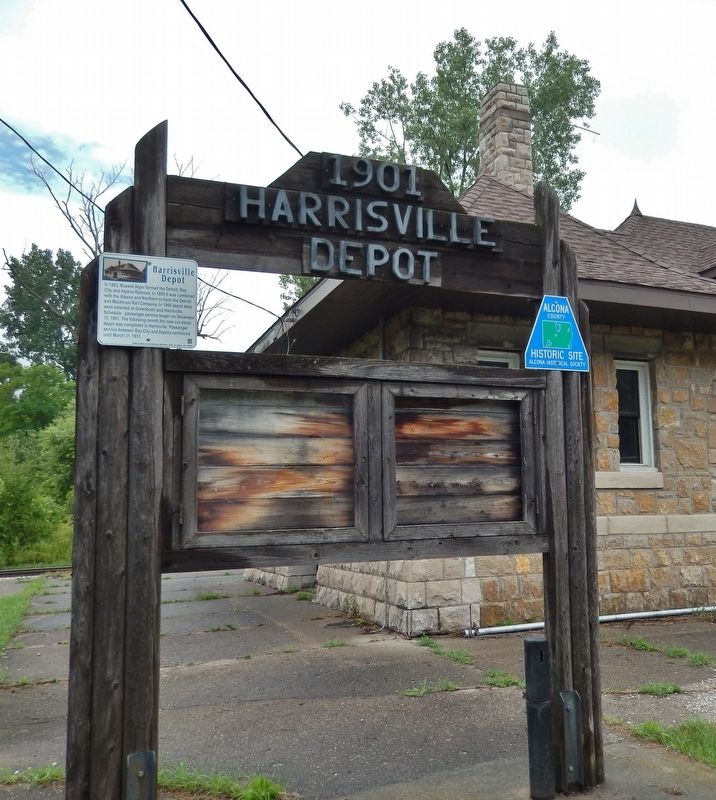
In 1883, Russell Alger formed the Detroit, Bay City and Alpena Railroad. In 1895 it was combined with the Alpena and Northern to form the Detroit and Mackinaw Rail Company. In 1900 depot sites were selected at Greenbush and Harrisville. Scheduled . . . — — Map (db m121975) HM
Near Old Allegan Road, 0.2 miles north of 57th Street, on the left when traveling north.
1825 - Trading post established by Louis Campau (a Frenchman) at the mouth of the Rabbit River approximately one mile upstream from what is now New Richmond.
1825 - Mack’s Landing trading post established where Purdy’s Landing is now . . . — — Map (db m73571) HM
Near Old Allegan Road, 0.3 miles east of 58th Street.
New Richmond got its start in 1836, when three eastern investors, led by John Allen of Ann Arbor, arranged to found a city here. John Allen, a Virginian by birth, purchased 2240 acres in Allegan County on the north side of the Kalamazoo River just . . . — — Map (db m73573) HM
Near Old Allegan Road, 0.3 miles east of 58th Street.
The railroad has been a central component of New Richmond’s history from the very beginning. The first railroad bridge crossing the Kalamazoo River at New Richmond was completed in 1871. It was originally built for the Chicago & Michigan Lake Shore . . . — — Map (db m73572) HM
On 10th Street at Templeton Street, on the right when traveling north on 10th Street.
On the 8th day of January, 1836, Mumford Eldred along with his second wife, Jane, and five children, settled on 40 acres in section 29 of Martin Township. The land included a 30 acre clearing on which the northern edge lived a small band of . . . — — Map (db m74657) HM
On 124th Avenue east of Pearl Street, on the right when traveling east.
In the 1870's the Village of Shelbyville was created by the arrival of the Grand Rapids and Indiana Railroad. Shelbyville was named after the first railroad station agent, Mr. Shelby. Since there was already a Michigan town named Shelby, the . . . — — Map (db m74594) HM
In 1891-92 the Chicago and West Michigan Railway, precursor to the
Pere Marquette Railroad, extended the line between Traverse City and
Petoskey through Spencer Creek. William Alden Smith, the railway's
general counsel, advocated building the . . . — — Map (db m190676) HM
Near West Apple Street, on the right when traveling east.
Hastings was first linked
with Jackson and Grand
Rapids by the Grand River
Valley Railroad in 1870.
The Michigan Central Railroad leased the line that
same year. At first located
elsewhere, a passenger
station was built on this
site in . . . — — Map (db m216359) HM
Near Adams Street at 4th Street, on the right when traveling north.
Before the advent of the World Wide Web, indeed even before the advent of telephones and automobiles, it was the railroad that kept us connected. Communities to communities. Businesses to customers. People to one another. Americans to their . . . — — Map (db m131789) HM
On Center Avenue at Adams Street, on the right when traveling east on Center Avenue.
Historic photographs show two traffic control shacks located on Center Avenue east and west of the railroad tracks that ran down what is now Jefferson Avenue. These hexagon-shaped buildings housed guardsmen when trains left or arrived at the F & PM . . . — — Map (db m182352) HM
On Thompson Avenue, 0.1 miles Michigan Avenue, on the right when traveling east.
Thompsonville Junction
Constructed in 1889, Thompsonville Junction’s diamond crossing formed the intersection of the Chicago and Western Michigan Railroad (eventually the Chesapeake and Ohio) and the Frankfort and Southeastern Railroad . . . — — Map (db m228950) HM
On South Paw Paw Street, 0.1 miles north of East St. Joseph Street, on the right when traveling north.
Built in 1910 by the Benton Harbor-St. Joe Railway and Light Company, this station served passengers and freight until 1928.
The station’s transformer provided Coloma’s first source of electricity. The electrified interurban rail line originally . . . — — Map (db m184099) HM
Near Dey Street east of N. 5th Street (Michigan Highway 51), on the right when traveling east.
(Obverse Side)
Michigan Central Railroad Depot
This Richardsonian Romanesque-style depot was constructed in 1892 by the Michigan Central Railroad Company. Seeking to create a lasting impression of Michigan for passengers . . . — — Map (db m68480) HM
Near Front Street (State Highway 139) south of Wayne Street, on the left when traveling north.
The St. Joseph River and the Sauk Trail (now U.S. 12) were major transportation routes for Indians, French voyagers, missionaries, military and early settlers through Niles. Nile's first railroad, the Michigan Central Railroad arrived October 1, . . . — — Map (db m68537) HM
On Water Street west of State Street, on the right when traveling west.
St. Joseph's swing bridge allows passage for both maritime and railroad commerce. An alternative to a drawbridge, the swing bridge pivots open for vessels to pass and closes for trains to cross. St. Joseph's swing bridge is typically left open until . . . — — Map (db m68223) HM
On North Matteson Road (U.S. 12) north of West Chicago Street (U.S. 12), on the left when traveling north.
Bronson was named after Jabez B. Bronson, who was
the first settler to the area, moving here from Ohio
in 1828. He became the first postmaster in 1830,
calling it Bronson's Prairie. It was Incorporated as a
village in 1866. The name was . . . — — Map (db m165471) HM
Thanks to late 1800s area artist J.P. Palmer, many local river scenes were preserved in watercolor and oil. Moving here at age 10 from New York, he went on to study at Albion College and the Chicago Art Institute. His paintings were in great demand . . . — — Map (db m95653) HM
On Coldwater St., on the left when traveling east.
There was a trestle here for a narrow gauge railway from Turtle Lake, 2 miles to the north, to the cement factory in the SE corner of town for transporting marl. The railway crossed both the St. Joe and Coldwater Rivers. Peerless Portland Cement . . . — — Map (db m95167) HM
On North McCamly Street at West Van Buren Street, on the right when traveling north on North McCamly Street.
The Michigan Central Railroad Depot opened on July 27, 1888. Rogers and McFarlane of Detroit designed the depot, one of several Richardsonian Romanesque-style stations the Michigan Central built between Detroit and Chicago in the late nineteenth . . . — — Map (db m177339) HM
On East Michigan Avenue, on the right when traveling west.
W.D. Robinson •
J. C. (Yankee) Thompson •
Sam Keith •
Linus Keith •
Tommy Nixon •
Sam Amlar •
Tom Faulkner •
John Brown •
Henry Larthrop •
Henry Hall •
John McCurdy •
Uriah Stevens
History of The Brotherhood of Locomotive . . . — — Map (db m216517) HM
On West Michigan Avenue, on the right when traveling west.
The murals to the right, depict the history of
this Michigan Avenue business site.
The interurban depot was located here
from 1903 until 1929 at which time the
electric railway went out of business.
Richard C. Walters, Sr. purchased the
vacant . . . — — Map (db m216526) HM
On West Hanover Street at South Linden Street, on the right when traveling east on West Hanover Street.
In April 1863 a meeting held here at the home of Jared C. Thompson led directly to the organization of the Brotherhood of the Footboard. Under the leadership of Marshall’s William D. Robinson, founder and first Grand Chief Engineer, 54 locals were . . . — — Map (db m177181) HM
On Michigan Avenue, 0.1 miles west of North Grand Street, on the right when traveling east.
The Interurban The Jackson and Battle Creek Traction Company began interurban service to Marshall in 1903. Its electric trains were powered by overhead lines in towns and by a sometimes deadly third rail in the countryside. Often just a single . . . — — Map (db m177219) HM
On South Park Street at Ray Street, on the right when traveling south on South Park Street.
This Railroad Office Building served as the Boyne City, Gaylord and Alpena Railroad general office during Boyne's lumbering era.
It is not known when the office building was constructed, but it was first located on the east side of Lake . . . — — Map (db m216179) HM
On Water Street at Front Street, on the left when traveling west on Water Street.
This location, at the head of Pine Lake (now Lake Charlevoix), was once the site of the round house for the BCG & A Railroad. Built shortly after the turn of the century, it sheltered and serviced thirteen locomotives. The surrounding railroad . . . — — Map (db m230468) HM
On North Huron Avenue at East Jamet Street, on the right when traveling north on North Huron Avenue.
Chief Wawatam was revered for his bravery and fidelity
Chief Wawatam, an Ojibway Indian living at the Straits of Mackinac, treated the British fur trader Alexander Henry as a brother. During the Indian attack on Fort Michilimackinac in . . . — — Map (db m214253) HM
Near South Huron Avenue north of Railroad Avenue, on the right when traveling north.
Founder of Mackinaw City Presented at the dedication of the statue of Edgar Conkling by Jerry Prior in Conkling Heritage Park
Edgar was born in New York during the War of 1812, while Mackinaw City was still a British territory. He was raised . . . — — Map (db m131698) HM
On North Huron Avenue, on the right when traveling east.
The long-anticipated railroads finally arrived in the Straits in 1881 and 1882. Their arrival, originally expected before the Civil War, was delayed by the War and then by shifting priorities. Once here, they brought many jobs, many visitors, and . . . — — Map (db m105924) HM
On North Huron Avenue, on the right when traveling east on North Huron Avenue.
Side 1
In 1634 Samuel de Champlain sent Jean Nicolet from Quebec to explore this area and make peace with the Ottawa and Ojibwa Indians. French traders were in the area in 1673, but they left when conflict with the Indians ensued. The . . . — — Map (db m105887) HM
On South Huron Avenue south of Mackinaw Crossings Drive, on the left when traveling south.
Mackinaw City Railroad Dock
Before the Mackinac Bridge opened in 1957, ships were the only means of connecting Michigan's peninsulas. During the 1870s, small sailing vessels served as ferries. Steamboats took over when the Michigan Central . . . — — Map (db m131700) HM
Sixty-two miles of hiking and biking through northern Michigan
The Michigan Department of Natural Resources welcomes you to the 62-mile North Central Trail. This multipurpose recreational trail runs from Mackinaw City to Gaylord, and has . . . — — Map (db m214023) HM
On South Huron Avenue at Mackinaw Crossing Drive, on the right when traveling north on South Huron Avenue.
The construction of railroads into Northern Michigan closely followed the lumbering industry. In 1881, the Michigan Central completed its line into Mackinaw, and the Mackinac and Marquette reached St. Ignace in the same year. To complete the . . . — — Map (db m138432) HM
On North Huron Avenue at East Sinclair Street, on the right when traveling north on North Huron Avenue.
Mackinaw's economy was originally built on the fur trade. When that faltered in the 1840s it was supplanted by fising, lumbering, and today's tourism.
The summer of 1871 was hot, dry, and windy, resulting in devastating fires across the . . . — — Map (db m140869) HM
On Depot Street at East Main Street (County Highway 58), on the right when traveling south on Depot Street.
In 1881, John M. Sanborn surveyed land owned Daniel McKillop and platted the village of Torrey. That year a post office opened here under the name "Wolverine." In 1882 the village was replatted as Wolverine. By the turn of the century, lumbering . . . — — Map (db m138106) HM
On Depot Street south of East Main Street (County Highway 58), on the right.
In the northern Lower Peninsula, the first railroads were built to move lumber from station to mill and from mill to cities. Later, their main business became moving passengers from one town to another. Many northern counties quadrupled their . . . — — Map (db m138120) HM
On East Main Street (County Route 58) at Ballard Street on East Main Street.
The Michigan Department of Natural Resources and Environment welcomes you to the 62-mile Gaylord to Mackinaw City Railway. The multipurpose recreational trail, which is 10 feet wide, has been upgraded to a surface of crushed limestone to provide a . . . — — Map (db m213612) HM
On South Clare Avenue, on the left when traveling north.
Michigan's lumbermen found many areas were too far from rivers for logs to be taken to the mills in the spring drive. After 1870 the logging railroad came into increasing use as the means of opening these regions. The Lake George and Muskegon . . . — — Map (db m190692) HM
On North Main Street, on the right when traveling north.
Village of Ovid
In 1836, inhabitants of Ovid, Seneca Falls County, New York, began to settle this fertile farm area. Among them were Samuel Barker, who built his log cabin in "Section 6;" Jabez Denison, noted for his prowess in killing . . . — — Map (db m119352) HM
On East Michigan Avenue south of Norway Street, on the right when traveling south.
December of 1872, Jackson, Lansing & Saginaw Railroad Company had laid track to Crawford and a freight house was built. In those days railroad companies named the Railway Stops, and in this instance the J.L. & S. Decided on Crawford. The present . . . — — Map (db m125498) HM
On Ogden Avenue south of South 6th Street, on the right when traveling south.
Charles Brotherton
In 1852 Charles Brotherton came to the Upper Peninsula with a survey team organized by William Burt. Two years later, Peter White hired him to survey the land between the Menominee River and Marquette. His work in the . . . — — Map (db m139050) HM
On Ludington Street east of South 2nd Street, on the left when traveling east.
At your immediate left, the first dock you see is the decaying Chicago and Northwestern Railway Dock, locally called the Merchant's Dock. Most of Escanaba's freight and passengers to and from the South and East came and went over this dock before . . . — — Map (db m137161) HM
On Ludington Street east of South 2nd Street, on the left when traveling east.
From this port, beginning in 1864
and ending with the Ore Centennial
Year 1964, more than 340,000,000
tons of iron ore were shipped.
The Chicago and North Western
Railway Company, iron ore-handlers
for 100 years, built the big dock . . . — — Map (db m137259) HM
On Ludington Street east of South 2nd Street, on the left when traveling east.
Starting in 1861, the Civil War tore apart the nation and resulted in the immediate need of iron ore to provide weapons for the North. William B. Ogden, an owner of the Chicago & Northwest Railroad Co., knew of the plentiful iron mines of the . . . — — Map (db m137258) HM
Near State Park Road, 1 mile west of II Road (State Highway 183).
A couple of cars loaded with lumber broke loose at the top of the Mud Lake grade and ran into some coal cars at its foot with sad results to all. Escanaba Iron Port 1882
By 1872, the Jackson Iron Company had built a six-mile railroad . . . — — Map (db m128855) HM
On Woodland Avenue (U.S. 31) at Reed Avenue, on the left when traveling east on Woodland Avenue.
J. W. Howard completed this spacious inn in 1887, naming it the Woodland Avenue House because of its proximity to that street. Later he called the hotel the Howard House. In 1923 the popular resort became the Roselawn in honor of Horace Rose, . . . — — Map (db m97565) HM
On Main Street (State Highway 119) at Judd Street, on the left when traveling west on Main Street.
The many-sided house across the street, sheathed in steel plates, was built for Ephraim Shay, inventor of the Shay locomotive. Patented in 1881, the locomotive operated by a gear-drive mechanism. Its great traction power and ability to operate on . . . — — Map (db m97600) HM
On Bay Street west of State Street, on the left when traveling west.
The Grand Rapids and Indiana Railroad linked Harbor Springs to its main line in 1882, further opening the Little Traverse Bay area to resort and commercial development. Grand Rapids architect Sidney J. Osgood designed this depot, built in 1889, . . . — — Map (db m97604) HM
On Bay Street at Lewis Street, on the left when traveling east on Bay Street.
This station, built in 1899, served as the region’s transportation hub. The Hemingway family passed through it often when going from Harbor Springs to their Walloon Lake cottage. Hemingway himself used the station when travelling north from his . . . — — Map (db m97879) HM
On Lewis Street at Rose Street, on the right when traveling south on Lewis Street.
During the late nineteenth and early twentieth centuries, city-dwellers from the Midwest escaped hot summers in the fresh air of northern Michigan. Constructed in 1899 for Norman J. Perry, the Hotel Perry catered to these vacationers with its . . . — — Map (db m97875) HM
On Bayfront Drive north of Lake Street, on the right when traveling east.
Built by the Chicago and West Michigan Railroad in 1892, this building later served as the Pere Marquette Railroad’s main station and Hemingway likely used it when traveling between Charlevoix and Petoskey. It became the Little Traverse History . . . — — Map (db m97998) HM
On West Vienna Street near Railway Street, on the left when traveling east.
In 1862 the Flint Pere Marquette Railroad built its original 26.1-mile section of track from Saginaw to Mount Morris. It selected Clio, originally known as Varna, as a railroad station location. The area around Varna was covered with white pine. The . . . — — Map (db m138086) HM
On North Leroy Street at Main Street, on the right when traveling north on North Leroy Street.
Constructed soon after the Detroit and Milwaukee Railroad reached town in 1855, this hotel has been a favorite resting and dining spot for over a century. It was said in 1883 that the guests were "entertained in a style unsurpassed in many large . . . — — Map (db m94761) HM
On East 1st Street at Wallenberg Street, on the right when traveling west on East 1st Street.
Henry Howland Crapo Near this site stood the home of Henry Howland Crapo (1804-1869). Born in Massachusetts, Crapo in 1858 moved his family to Flint, where he had invested in timber land. Here, he developed a prosperous lumbering business, . . . — — Map (db m178409) HM
Near North Bray Road, 0.3 miles north of East Coldwater Road.
Built in Davison between 1890 and 1900, the Davison Depot was a "flag stop" on the Grand Trunk Western Railroad Line. It was a gathering place for passengers and a drop off spot for the mail.
The Depot did not have scheduled stops. The train . . . — — Map (db m225260) HM
On West Walker Street at Walnut Street, on the right when traveling west on West Walker Street.
Village Of Gaines Between 1855 and 1858 the Detroit and Milwaukee Railway built a rail line from Detroit to Grand Haven. In 1856 Gaines Station was established as a rail stop and post office. In 1859 Henry Walker platted the town, aligning the . . . — — Map (db m178334) HM
On Beech Street at East Houk Street, on the right when traveling south on Beech Street.
This site is dedicated to the memory of those who developed the Ironwood area, the immigrants, farmers, loggers, railroaders, and iron ore miners.
Iron ore was first discovered here by James A. Wood in 1882 and the Norrie "A" mine shaft was sunk . . . — — Map (db m201422) HM
On 1238 Wall Street, 0.1 miles east of Luxmore Drive, on the right when traveling east.
When they say "cold as heck," they're talking about this place, Kaukauna, Wisconsin. The birthplace of the Stormy Kromer Cap. It was here, in 1903, that George "Stormy" Kromer finally lost his cool. And his hat
He was an engineer on the . . . — — Map (db m77345) HM
On East Saginaw Street (State Highway 46), on the left when traveling east.
Saginaw and Gratiot County State Road
In 1867 goods for Gratiot and Isabella Counties were shipped from Detroit to St. Johns, then hauled by teams of horses to outlying settlements. In an effort to lessen the exhorbitant . . . — — Map (db m106669) HM
On East Chicago Road (U.S. 12) at West Street, on the left when traveling east on East Chicago Road.
A grand celebration and a baseball game greeted the Michigan and Ohio Railroad when its track reached Moscow on September 4, 1883. This Stick Style station, completed the following month, was "quite an ornament to the place," according to the . . . — — Map (db m66791) HM
On Red Jacket Road, 0.1 miles east of 4th Street, on the right when traveling east.
The Calumet and Hecla Mining Company couldn't allow winter to derail its operation. In a remote region that can receive upwards of 300 inches (762 cm) of snow each year, snow removal was serious business. Clear rail lines were essential for moving . . . — — Map (db m122496) HM
On West Lakeshore Drive, 0.2 miles west of Quincy Street, on the left when traveling west.
The Copper Range Company was a fully integrated industrial enterprise, operating the Champion, Baltic and Trimountain copper mines south of Houghton, a number of milling facilities, and a large smelting works along Portage Lake. It was a late . . . — — Map (db m153999) HM
On West Lakeshore Drive, 0.2 miles west of Quincy Street, on the right when traveling west.
Houghton wasn't merely a port for the pass-through of raw materials and wholesale goods. Throughout its history, the city's central waterfront location was attractive to manufacturing and industrial operations. As with the larger Keweenaw Peninsula, . . . — — Map (db m154076) HM
On Main Street (State Highway 25) at Pine Street, on the right when traveling east on Main Street.
from the
Pontiac Oxford
and Northern R.R.
(now Grand Trunk Western)
laid about 1882
between
Caseville and Pontiac
On July 17 1961, this was the first rail removed when the last 6 miles of the original track from Caseville to Pigeon . . . — — Map (db m180792) HM
On Water Street at State Street, on the right when traveling north on Water Street.
In 1878 the Port Huron and Northwestern Railroad began laying track from Port Huron to Minden City, where it would branch off to Bad Axe and Port Austin. J. Jenks & Co. convinced the railroad company to continue the track from Minden City to Sand . . . — — Map (db m213484) HM
On South Main Street (Michigan Route 142) 0.1 miles south of Michigan Avenue, on the right when traveling north.
The Pigeon Depot was constructed in 1908 and served two railroad lines. In 1883 the Pontiac, Oxford and Port Austin Railroad, a north-south line, had been extended to Caseville and a depot was built at Berne, one mile north of here. Around 1886 the . . . — — Map (db m160812) HM
On State Road near Portland Avenue, on the right when traveling east.
Train Arriving in Port Hope
The long awaited railroad reached Port Hope in October of 1903, providing both freight and passenger service on a year-round basis.
Engine House
After a 1910 fire destroyed the Harbor Beach roundhouse, . . . — — Map (db m225905) HM
Near South Washington Avenue, on the right when traveling north.
Constructed in 1902, this castle-like building with its square tower was the Lansing station for the Grand Trunk Western Railroad until 1971. For decades passengers streamed through its doors. Here servicemen left and returned from military duty. . . . — — Map (db m104014) HM
On South Washington Avenue near East South Street, on the right when traveling north.
First known as the Grand Trunk Western Railway Station, Lansing Depot, this impressive structure,
built in 19th and 20th century architectural styles, was designed by the Detroit architectural firm Spier
and Rohns, with construction beginning in . . . — — Map (db m214342) HM
On East Michigan Avenue near Pere Marquette, on the right when traveling west.
The Union Depot began passenger service for the Michigan Central and Pere Marquette Railroads in 1902. The Detroit architectural firm of Spier and Rohns, which planned many Michigan Central stations, designed the building with Chateauesque conical . . . — — Map (db m103659) HM
On Mason Street at Center Street, on the left when traveling north on Mason Street.
This depot was built by the Michigan
Central Railroad, Saginaw Division.
It was opened November 24, 1902 Serving
this area for over 50 years. — — Map (db m171674) HM
On Depot Street at North Bridge Street, on the right when traveling west on Depot Street.
Pere Marquette Depot
built in 1921
has been placed on the
National Register
of Historic Places
by the United States
Department of the Interior — — Map (db m216064) HM
On Depot Street at North Bridge Street, on the right when traveling west on Depot Street.
Completed in 1923 for the Pere Marquette Railway, this depot is typical of the railroad stations that served Michigan towns during the early decades of the twentieth century. The depot replaced an earlier, wood frame station built during the 1880s . . . — — Map (db m216177) HM
On West Main Street, on the left when traveling east.
This one horse plow represents Ionia
County's agricultural past, an important
industry throughout local history. Farming
became especially profitable after the
railroads were built through Ionia, as it gave
the farmers a quicker and more . . . — — Map (db m216306) HM
On West Main Street, on the right when traveling east.
This artifact recalls the importance of the
railroads to Ionia's growth. The first
railroad reached Ionia in 1857, and a
second was built in 1869. In 1871-72, the
Pere Marquette Railroad constructed a
roundhouse and shop in Ionia to . . . — — Map (db m216317) HM
On Portland Riverwalk south of Morse Drive, on the right when traveling south.
Railroads were vital to early residents for receiving goods and moving local produce to market. The first train into Portland arrived in November 1869. In 1881, in addition to freight trains, there were six passenger trains daily, three in each . . . — — Map (db m198483) HM
“Oscoda and AuSable are Wiped Off The Map!” headlined the July 12, 1911, Detroit Free Press. The day before, forest fires, fanned by thirty-mile-per-hour winds, had destroyed these “twin cities” and killed four people. Refugees fled to this . . . — — Map (db m154600) HM
On Brady Avenue, 0.1 miles north of Caspian Avenue, on the left when traveling north.
The Apple Blossom Trail, established in 1994, begins on the south end in Caspian on a spur off the Chicago & Northwestern Main Line. It is located along the Iron River, which joined the three cities of Caspian, Stambaugh, and Iron River . . . — — Map (db m213376) HM
Near Brady Avenue, 0.2 miles north of Caspian Avenue, on the right when traveling north.
This ore car is dedicated to the Chicago Northwestern Railway and to the railroad men and miners who produced the ore to be hauled. The rails were extended to Iron River and Crystal Falls in 1882. In the first year 29,115 tons of ore were shipped. . . . — — Map (db m213344) HM
Near Brady Avenue, 0.2 miles north of Caspian Avenue, on the right when traveling north.
Car #1: A 1920 electric locomotive with 4 motors and weighs 10 tons with a speed of 6.6 MPH. The wooden boom connected this car to the overhead power line for direct current. The driver stood on the rear of the car. Car #2: Mucking machine . . . — — Map (db m213457) HM
Near Brady Avenue, 0.2 miles north of Caspian Avenue, on the right when traveling north.
These jams were used to lift logs onto sleighs in the woods that took the logs to the railroad. Also, used to lift logs off sleighs and on to railway cars that transported the logs to the mills. — — Map (db m213412) HM
On West Michigan Avenue at Wolf Lake Road on West Michigan Avenue.
This replica of a turn of the century interurban rail waiting station is built on the former right of way of the D.U.R. - the Detroit Urban Railway. The D.U.R. was one of two interurban lines found in Grass Lake from about 1890 to the mid-1920's. . . . — — Map (db m211989) HM
On East Michigan Avenue at Drake Street, on the left when traveling east on East Michigan Avenue.
Grass Lake
The first settlers arrived in Grass Lake in 1829. Two years later a post office, the second in Jackson County, opened at the settlement. In 1832 Grass Lake Township was created; the current boundaries were established in 1836. . . . — — Map (db m55223) HM
On West Michigan Avenue, on the left when traveling east.
The Central Railroad (later named the Michigan Central Railroad or MCRR) came through Grass Lake in 1842. When the stone depot was built in 1887, the original wooden station was tom down. Located at 210 E. Michigan Ave., this railroad station . . . — — Map (db m226821) HM
On West Michigan Avenue, on the left when traveling east.
Michigan Central's 4-4-0 locomotive #6 was built in 1877. It was renumbered to #156 in 1897. MCRR locomotive #6 was rebuilt and modernized in October 1902 and retired in 1922. The steep ramp in the background was constructed so that horse-drawn . . . — — Map (db m226820) HM
On East Michigan Avenue (Business Interstate 94) at South Park Avenue, on the right when traveling east on East Michigan Avenue.
The Final Ride to Midnight
This property originally a freight depot offered a rail ride to freedom on the fastest transportation possible, but it came with a cost. Imagine hiding among the cargo knowing that if you're found you could be . . . — — Map (db m210727) HM
On Michigan Avenue (Business Road 94) at Park Avenue, on the right when traveling east on Michigan Avenue.
Michigan Central Railroad (MCRR) stations between Chicago and Detroit formed a freedom corridor that helped self-liberated persons escape slavery prior to the Civil War. The MCRR'S Jackson passenger station played a key role in the lives of the . . . — — Map (db m223756) HM
On East Michigan Avenue (Business Interstate 94) near South Edwards Street, on the right when traveling east.
Development began in the Haymarket district as early as the 1830s and was spurred by the construction of the Grand Rapids and Indiana Railroad Depot in 1870. The district became a hub for retail, wholesaling and light manufacturing. It was the . . . — — Map (db m190214) HM
On East Michigan Avenue (Business Interstate 94) at South Kalamazoo Mall, on the right when traveling west on East Michigan Avenue.
Railroads (north side)
The Michigan Central Railroad whistled into Kalamazoo in 1846, linking it with critical eastern markets. The Lake Shore (1867) and Grand Rapids & Indiana (1870) then arrived from the south. Another line . . . — — Map (db m203985) HM
Near Lyon Street Northwest, 0.1 miles west of Monroe Avenue Northwest.
Grand Rapids is a city divided by the Grand River. In its earliest days, settlers crossed the river in small boats or canoes, or on frozen ice during the winter and temporary foot bridges in the summer. The need to tie the city together led to . . . — — Map (db m153292) HM
On East Main Street (Michigan Route 21) near North Monroe Street.
North Side
At one time buildings nearly filled the north side of
the Bridge except for a small opening east of Mainstreet
Inn. The most prominent building is the old Post Office
building, built in 1884 after a fire destroyed the . . . — — Map (db m216763) HM
On West Main Street (Michigan Route 21) near South Broadway Street, on the right when traveling east.
This has been an area of intense business activity and
commerce since the Pere Marquette railroad was
extended to Saginaw via Lowell and Belding and a new
depot was built between S. Broadway and Hudson.
Lowell Mfg. Co. would load sprayers . . . — — Map (db m216901) HM
On Summit Avenue Northeast at Summit Court Northeast, on the right when traveling south on Summit Avenue Northeast.
The Grand Rapids and Indiana Railroad (GR&I) reached Algoma Township in 1867. A series of wooden trestles were built to cross Wicked Creek, later named Stegman Creek. In 1885, after repeated fires and floods, the GR&I hired James House to cut . . . — — Map (db m182793) HM
On North Union Street near East Mark Street, on the right when traveling north.
In 1888 the Toledo, Saginaw and Muskegon Railway (TS&M) built this depot. It was one of six constructed that year on the line between Muskegon and Ashley. The depot typifies country “combination-type” depots; it sheltered passengers, the station . . . — — Map (db m182794) HM
On 2nd Street (Gay Lac La Belle Road) east of Lake Street, on the left when traveling east.
Gay was established in 1901, when the Mohawk and Wolverine mining companies each built a stamp mill here to process copper ore from their mines. The area, once known for quarrying, lumbering, and fishing, developed into a booming mill town named for . . . — — Map (db m153268) HM
On First Street south of Pine Street (Route 44), on the left when traveling south.
In the nineteenth century, railroads provided the prime transportation link between small villages and the rest of the country. The first Columbiaville depot was built near this site in 1872. In 1893 William Peter (1824-1899) replaced that structure . . . — — Map (db m101541) HM
258 entries matched your criteria. The first 100 are listed above. Next 100 ⊳